

Last modified: 23 October 2020
Background
The Churchill Province was defined by Stockwell (1961) as a tectonic province of the Canadian Shield. This definition included the northern portion of the Ungava Peninsula, the Ungava Orogen, and the Southeastern Churchill Province (SECP), located in NE Quebec and Labrador, between the Superior and Nain provinces. Hoffman (1988, 1990) proposed that the Ungava Orogen correspond to an extension of the Trans-Hudsonian Orogen, while the amalgam of Archean rocks located in the centre of the SECP would have an affinity with the Rae Province.
The Trans-Hudsonian Orogen was subsequently identified as a large, continuous zone affected by a tectonometamorphic imprint caused by collisions that occurred between 1.83 and 1.80 Ga (Lewry and Collerson, 1990; Corrigan et al., 2009), resulting in the New Quebec and Torngat orogens being included. The term “Core Zone” is introduced by James et al. (1996) to define a central zone that is composed of an amalgam of Archean rocks remobilized in the Paleoproterozoic, and some of which would have an affinity with the Superior and Rae provinces. St-Onge et al. (1998) subsequently demonstrated that an E-W segment of the Trans-Hudsonian Orogen extended into southern Baffin Island, thereby negating any possible connection between the Rae Province and the Core Zone. The term “Southeastern Churchill Province (SECP)” appears to have been first used by James et al. (1996). It has been included in several subsequent publications, including the regional synthesis of Wardle et al. (2002).
Various names were used to describe the Trans-Hudsonian Orogen segment at the northern end of the Ungava Peninsula: Cape Smith Orogen (Hoffman, 1988), Ungava Trough (Lamothe, 1994), and Ungava Orogen (St-Onge et al., 1992a, b; Lamothe, 2007).
Description
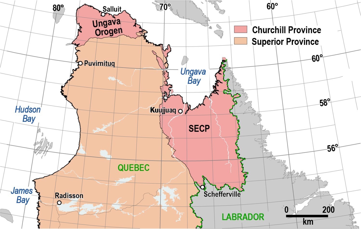
The Churchill Province borders the Superior Craton. It outcrops in NE Quebec and on the northern tip of the Ungava Peninsula. The SECP straddles the Quebec-Labrador border. It is 415 to 615 km long by 250 to 380 km wide, in a NNW-SSE general orientation. It is bordered to the west by the Superior Province, to the east by the Nain (North Atlantic Craton and Burwell Lithotectonic Domain) and Makkovik provinces, and to the south by the Grenville Province.
The Ungava Orogen is located in the northern Ungava Peninsula. It stretches nearly 300 km from the Hudson Bay in the west to the Hudson Strait in the north and east. To the south, it is limited by the Superior Province.
Geology
The Quebec portion of the Churchill Province is part of the Trans-Hudsonian Orogen, an area affected by a continuous tectonometamorphic imprint and caused by collisions that occurred at ~1.9 Ga to 1.8 Ga (Lewry and Collerson, 1990; Corrigan et al., 2009). These collision zones surround the Superior Craton and bind together smaller cratons, such as the North Atlantic Craton. Asymmetric geometry recognized by Hoffman (1988) is common to the different segments of the Trans-Hudsonian Orogen. It includes fold and thrust belts composed of weakly metamorphosed supracrustal rocks, as well as a hinterland of Archean crust, highly remobilized in the Paleoproteozoic, and magmatic arcs. This general pattern is found in both the SECP and Ungava Orogen.
Southeastern Churchill Province
The SECP consists of several lithotectonic blocks of different origins that have been amalgamated during the Trans-Hudsonian Orogen. In the SECP, this event can be broken down into two successive transpressive orogens, the Torngat in the east and the New Quebec in the west (Wardle et al., 2002).
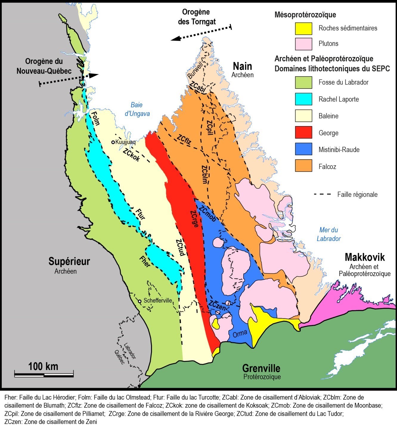
The central portion between these orogens, defined as the Core Zone by James et al. (1996), was previously roughly subdivided into domains by different authors, with no systematic synthesis across the SECP. Following geological surveys the Ministère between 2009 and 2017, Lafrance et al. (2018) propose a subdivision of the SECP into six lithotectonic domains, which are from west to east: the Labrador Trough and the Rachel-Laporte, Baleine, George, Mistinibi-Raude and Falcoz lithotectonic domains.
The Labrador Trough is a metamorphosed volcano-sedimentary belt (greenschist to amphibolite facies) of Paleoproterozoic age (2.17-1.87 Ga), folded and overthrusted on the Superior Craton during the New Quebec Orogenesis. It extends over a length of >850 km, from the Grenville Province in the south to the Ungava Bay in the north. Contact with the Superior Province in the west is mainly represented by the Maraude Fault. Contact with the Rachel-Laporte Lithotectonic Domain, in the east, is rather marked by various echelon faults running from north to south, namely the Pointe Reef, Lac Hérodier and Lac Keato faults.
The Rachel-Laporte Lithotectonic Domain consists of Paleoproterozoic metamorphosed volcano-sedimentary rocks (amphibolite facies) of the Laporte Supersuite (<1.84 Ga; Henrique-Pinto et al., 2017), previously interpreted as equivalent to the Labrador Trough (Fahrig, 1965; Poirier et al., 1990; Wardle et al., 2002; Simard et al., 2013). Subsequent mapping indicates instead that the Laporte Supersuite metasedimentary rocks differ from those of the Labrador Trough by greater apparent thickness and more homogeneous composition. Detrital geochronological data from Henrique-Pinto et al. (2017) also indicate that these two sedimentary basins are derived from distinct tectonic sources and environments. The author’s work indicates that detrital zircons of the Kaniapiskau Supergroup units (Labrador Trough) have a signature typical of the Superior Province (maximum frequency around 2.72 Ga). In the case of the Laporte Supersuite, the maximal frequency of detrital zircons is at ~1.84 Ga, suggesting that the main source of sediment comes from SECP units. The Rachel-Laporte Domain also includes Archean structural complexes (imbricate blocks not belonging to the Laporte Supersuite), interpreted as having belonged to the Superior Province (Wardle et al., 2002), as well as tectonic slices exhaled during thrusting of the Baleine Lithotectonic Domain on the Rachel-Laporte Domain and Labrador Trough.
The Baleine Lithotectonic Domain consists of two sections (north and south), the boundary of which is approximately 30 km south of Kuujjuaq. The northern section consists mainly of Archean tonalitic gneiss (Ungava Complex; 2.7-2.9 Ga), migmatite (Qurlutuq Complex) and anatectic granite (Aveneau Suite) derived from partial melting of gneiss. It also includes a mafic to intermediate intrusive complex (Kaslac Complex) and volcano-sedimentary sequences (Curot and Akiasirviup suites) alternating with gneiss in its western part. The southern section includes a large, highly migmatitized supracrustal cover (False and Winnie suites), deformed Archean potassic units (Saffray Suite; 2.7 Ga), but also gneiss, migmatites and anatectic granites similar to those observed in the northern section. A metamorphosed potassic intrusion (Champdoré Suite), synchronous to the De Pas Supersuite (see George Domain below), is also present in the southern part of the domain. The southern portion of the Baleine Domain is also characterized by a domes and basins structural pattern (Charette et al., 2016). The Diana Structural Complex (Madore and Larbi, 2000) constitutes the separated NW end of the Baleine Domain. This unit consists mainly of gneissic tonalite with strips of paragneiss, amphibolite and ultramafic rocks, usually mylonitized and migmatized. Like the rest of the Baleine Domain, these rocks are Archean and Proterozoic in age and have been affected by intense ductile deformation and metamorphism in the Paleoproteozoic.
The George Lithotectonic Domain is dominated by Paleoproterozoic intrusions of the De Pas Supersuite (1.86-1.8 Ga), which have been emplaced within gneiss units and their partial melting products (Saint-Sauveur and Guesnier complexes; 2.6-2.7 Ga) and through a large Neoarchean metamorphosed volcano-sedimentary sequence (Tunulic Complex; 2.6-2.7 Ga). Limited by major shear zones to the west (Lac Tudor) and east (Rivière George), this domain is characterized by large mylonitic deformation zones. Charette et al. (2018) consider the George Domain to be a transition zone between tectonometamorphic overprinting of the New Quebec and Torngat orogens. Thus, this domain would represent a discontinuous or gradual transition between their contrasting orogenic styles.
The Mistinibi-Raude Lithotectonic Domain stands out in the near absence of Archean lithologies, with the oldest units bordering the Neoarchean and Paleoproterozoic (2.3-2.5 Ga), and the absence of magmatism around 1.8 Ga. It includes a large sequence of paragneiss and diatexite (Mistinibi Complex), metavolcanic rock units (Ntshuku and Zeni complexes), gneiss (Advance and Elson complexes) and a clastic metasedimentary sequence (Hutte Sauvage Group). The Mistinibi-Raude Domain is also characterized by the presence of numerous intrusions, mostly potassic, whose composition varies from felsic to mafic. Some of these intrusions have crystallized during the Paleoproterozoic and Neoarchean (Pelland, Nekuashu and Dumans suites). However, the majority of these intrusions are Mesoproterozoic and have been emplaced at the boundary between the SECP and Nain Province (Mistastin Batholith, Michikamau and Napeu Kainut suites). Charette et al. (2019) also include, in this domain, the Orma Domain, which represents an area south of the Zeni Shear Zone>, considering that these two areas are characterized by the absence of crystallization age 2.67 Ga, but mostly by the absence of metamorphic overprinting associated with the Trans-Hudsonian Orogen.
The Falcoz Lithotectonic Domain represents the SECP's eastern margin divided into two parts (west and east) and separated by the Blumath Shear Zone, which marks the passage of the upper amphibolite facies to the granulite facies. The western part is dominated by variously migmatitized gneiss (Kangiqsualujjuaq and Fougeraye complexes) and potassic intrusions (Siimitalik Suite), mostly Mesoarchean (2.7-3.0 Ga). It also includes a sequence of Paleoproterozoic metamorphosed volcano-sedimentary rocks (Lake Harbour Group) intruded by mafic to ultramafic dykes and sills (Nuvulialuk Suite). The eastern part of the Falcoz Domain is dominated by Archean granulitic orthogneiss (Sukaliuk Complex; 2.7-2.9 Ga) and Paleoproterozoic hypersthene intrusions (Inuluttalik Suite; 1.8 Ga). More to the east, this domain also includes intrusive rocks interpreted as the root of a magmatic arc emplaced on the SECP eastern margin around 1877 Ma (Bertrand et al., 1993). These rocks are grouped within the Lomier Complex, which includes supracrustal rocks (Koroc River Group), charnockitic intrusions (Courdon Intrusive Suite) and gneiss interpreted as being derived from deformation and the alternating Koroc River Group and Courdon Intrusive Suite.
All SECP lithotectonic domains are cut by Mesoproterozoic subophitic dykes (~1.3 Ga) which have been grouped into swarms of varying direction, the main ones being the Falcoz Swarm (NNW-SSE), Slippery Dykes (E-W) and Harp Dykes (NE-SW).
Ungava Orogen
The Ungava Orogen is divided into four lithotectonic domains, which are from north to south: the Narsajuaq, Kovik, Northern and Southern domains. The Narsajuaq and Kovik domains form the heart of the Ungava Orogen, and consist of remobilized Archean rocks and Paleoproterozoic intrusions. The Southern and Northern domains form a volcano-sedimentary belt deposited on the Superior Craton.
The Narsajuaq Lithotectonic Domain represents the most intensely metamorphosed and deformed part of the Ungava Orogen. It consists mainly of foliated to gneissic, intermediate to felsic intrusive rocks including the Tasialuk Allipaaq and Sainte-Hélène complexes (~2790 Ma) and the Sanningajualuk and Nallujuaq suites (~2560 Ma). The Narsajuaq Domain is characterized by the presence of orthopyroxene stratigraphic units covering large areas and testifying to granulite facies metamorphism. The main units are the Pingasualuit (~2770-2610 Ma) and Estre complexes, as well as the Navvaataaq (~2550 Ma), Fargues and Siurartuuq suites. All of the units alternate over hectometric to kilometric thicknesses, forming E-W oriented banding characteristic of the Narsajuaq Domain. Metasedimentary rocks of the Erik Cove Complex are also interstratified within the igneous and gneissic units.
The Kovik Lithotectonic Domain consists of an assemblage dominated by Archean to Paleoproterozoic, foliated to gneissic intrusive rocks and strips of metasedimentary rocks. Intrusive rocks are mostly tonalitic to granitic and often migmatized. Currently, Kovik Domain rocks are mainly grouped within the Kovik Complex, but will gradually be divided into separate units as mapping progresses. Unlike the Narsajuaq Domain, orthopyroxene is not present in the Kovik Domain, suggesting that metamorphism has not generally reached the granulite facies. The main new units already identified include gneiss of the Nanuk Complex, granodiorite of the Arvik Suite, migmatized paragneiss of the Crony Suite and mafic to intermediate intrusions of the Gastrin Suite.
The Northern Domain is a complex lithotectonic package that straddles the Southern and Kovik domains and is itself straddled by the Narsajuaq Domain. It is composed mostly of the Watts, Spartan and Parent groups, and the Cape Smith Suite. Relationships between groups are not clearly defined. The Watts Group consists mainly of a mafic to ultramafic layered igneous complex associated with extrusive expression and is therefore interpreted by some authors as an ophiolite (St-Onge et al., 1988) dated ~2 Ga. The Spartan Group consists of sedimentary rocks while the Parent Group is a volcanic arc unit. The Cape Smith Suite comprises a series of intrusions emplaced from 1890 Ma to 1836 Ma. Some of these intrusions are interpreted as the source of the Parent Group’s volcanism.
The Southern Domain, also known as the Cape Smith Belt, is the southernmost lithotectonic complex, it unconformably overlies the Superior Province and consists of lithological assemblages reflecting opening of a continental rift around 2038 Ma (Hegner and Bevier, 1991), and the subsequent transition to an active oceanic rift between 1883 Ma and 1870 Ma (Bleeker and Kamo, 2018). The Povungnituk Group is a volcano-sedimentary assemblage associated with the development of a continental rift. The Chukotat Group is composed of MORB-type basalts resulting from oceanic opening.
Geological Evolution

The Trans-Hudsonian Orogen is the major geological event that shaped the Churchill Province. This orogen is one of the most extensive of the Paleoproteozoic era. As early as 1973, Dewey and Burke applied plate tectonics to the Churchill Province and proposed that it be an analogue to the Tibetan Plateau, which is the hinterland of the Himalayan Orogen. Structural, metamorphic and geochronological studies of collision zones reveal the relationships between the different cratons and microcontinents that make up Churchill Province.
Early collision phases are located in distal position relative to the Superior Craton. In the Ungava Orogen, this early phase corresponds to the amalgamation of the Sugluk Block (Narsajuaq Lithotectonic Domain) with the Meta-Incognita microcontinent, which was located on Baffin Island around 1865 Ma (Corrigan et al., 2009). In the SECP, initiation of the continental collision with the Nain Province is dated between 1.89 and 1.81 Ga in metasedimentary rocks of the Tasiuyak Complex that was incorporated between the North Atlantic Archean Craton and the Falcoz Domain (Godet et al., 2021). The Meta-Incognita microcontinent is potentially linked to the Falcoz Domain (Corrigan et al., 2018). Thus both the early phases of continental collision would involve the Meta-Incognita microcontinent and be 15 to 20 million years older in the SECP than in the Ungava Orogen.
Detailed petrochronological data exist for the SECP and highlight the desynchronization of events to the east compared to those to the west. Thus, the central part of the SECP recorded a series of key events between 1840 and 1810 Ma. A period of magmatic activity was marked by intrusion of the De Pas Supersuite (1860-1805 Ma). At the same time, metamorphic paroxysm is reached in the Falcoz Domain around 1839 Ma (Charette, 2016). The formation of garnet circa 1836 Ma in the Baleine Domain is interpreted as indicating the age of the collision between the latter and the George Domain (Godet et al., 2020). The timing of syntectonic intrusions in the Rivière George Shear Zone constrains shear activity to a period prior to 1812 Ma (Dunphy and Skulski, 1996; Vanier, 2019). This shear zone is conjugate with the Moonbase Shear Zone which together form a ductile shear network accommodating approximately orthogonal shortening that characterizes this tectonic stage in the centre of the SECP (Vanier, 2019).
The major collision event in the western portion of the SECP corresponds to the New Quebec Orogen, during which the Baleine, Rachel-Laporte and Labrador Trough domains amalgamated with the Superior Craton. This collision occurred between 1.82 Ga and 1.77 Ga (Machado et al., 1989). A recent garnet dating result indicates mean-crust burial of Rachel-Laporte Domain metasediments at 1804 ±8 Ma (Godet et al., 2020).
Petrochronological data are still too fragmentary in the Ungava Orogen to be comparable to the SECP. However, formation of eclogite in the Kovik Domain between 1831 Ma and 1820 Ma (Weller and St-Onge, 2017) suggests that the continental phase of the collision was slightly later than reported in the centre of the SECP.
References
| Author(s) | Title | Year of Publication | Hyperlink (EXAMINE or Other) |
|---|---|---|---|
| BERTRAND, J.M. – RODDICK, J.C. – VAN KRANENDONK, M.J. – ERMANOVICS, I. | U–Pb geochronology of deformation and metamorphism across a central transect of the Early Proterozoic Torngat Orogen, North River map area, Labrador. Canadian Journal of Earth Sciences; 1993, volume 30, no 7, pages 1470-1489. | 1993 | Source |
| BLEEKER, W. - KAMO, S. L. | Extent, origin, and deposit-scale controls of the 1883 Ma Circum-Superior large igneous province, northern Manitoba, Ontario, Quebec, Nunavut and Labrador. In Targeted Geoscience Initiative: 2017 report of activities, volume 2. (ed.). Edited by N. Rogers. Geological Survey of Canada, Open File 8373, pages 5-14. | 2019 | Source |
| CHARETTE, B. | Long-lived Anatexis in the Exhumed Middle Crust from the Torngat Orogen and Eastern Core Zone: Constraints from Geochronology, Petrochronology, and Phase Equilibria Modeling. Master Thesis, University of Waterloo, 418 pages. | 2016 | Source |
| CHARETTE, B. – LAFRANCE, I. – MATHIEU, G. | Géologie de la région du lac Jeannin (SNRC 24B). Ministère de l’Énergie et des Ressources naturelles, Québec. | 2016 | Electroniqc geological report |
| CHARETTE, B. – LAFRANCE, I. – VANIER, M.-A. | George Lithotectonic Domain, Southeastern Churchill Province, Nunavik, Quebec, Canada: Geological Synthesis. Ministère de l’Énergie et des Ressources naturelles, Québec. BG 2018-11. | 2018 | BG 2018-11 |
| CHARETTE, B. – LAFRANCE, I. – GODET, A. – VANIER, M.-A. | Mistinibi-Raude Domain, Southeastern Churchill Province, Nunavik, Quebec, Canada: Geological Synthesis. Ministère de l’Énergie et des Ressources naturelles, Québec. BG 2019-07. | 2019 | BG 2019-07 |
| CORRIGAN, D. – PEHRSSON, S. – WODICKA N. – DE KEMP, E. | The Palaeoproterozoic Trans-Hudson Orogen: a prototype of modern accretionary processes. | 2009 | Source |
| CORRIGAN, D. – WODICKA, N. – MCFARLANE, C. – LAFRANCE, I. – VAN ROOYEN, D. – BANDYAYERA, D. – BILODEAU, C. | Lithotectonic Framework of the Core Zone, Southeastern Churchill Province, Canada. Geosci. Canada 45, pages 1-4. | 2018 | Source |
| DUNPHY, J.M. – SKULSKI, T. | Petrological zonation across the De Pas Batholith: a tilted section through a continental arc? In Eastern Canadian Shield Onshore–Offshore (ECSOOT) Transect Meeting 1996 (Wardle R.J. and Hall, J., editors). The University of British Columbia, Lithoprobe Secretariat; Report 57, pages 44-58. | 1996 | |
| FAHRIG, W.F. | Lac Hérodier, Québec. Geological Survey of Canada, map 1146A (annotated map). | 1965 | Source |
| GODET, A. – GUILMETTE, C. – LABROUSSE, L. – SMIT, M.A. – DAVIS, D.W. – RAIMONDO, T. – VANIER, M.-A. – CHARETTE, B. – LAFRANCE, I. | Contrasting P-T-t paths reveal a metamorphic discontinuity in the New Quebec Orogen: Insights into Paleoproterozoic orogenic processes. Precambrian Research; volume 342, page 105675. | 2020 | Source |
| GODET, A. – GUILMETTE, C. – LABROUSSE, L. – DAVIS, D.W. – SMIT, M.A. – CUTTS, J.A.– VANIER, M.-A. | Lu–Hf garnet dating and the timing of collisions: Palaeoproterozoic accretionary tectonics revealed in the Southeastern Churchill Province, Trans-Hudson Orogen, Canada. Journal of Metamorph Geology; 00, pages 1-31. | 2021 | Source |
| HEGNER, E. – BEVIER, M.L. | Nd and Pb isotopic constraints on the origin of the Purtuniq ophiolite and Early Proterozoic Cape Smith Belt, northern Quebec, Canada. Chemical Geology, volume 91, pages 357-371. | 1991 | Source |
| HENRIQUE-PINTO, R. – GUILMETTE, C. – BILODEAU, C. – McNICOLL, V. | Evidence for transition from a continental forearc to a collisional pro-foreland basin in the eastern Trans-Hudson Orogen: Detrital zircon provenance analysis in the Labrador Trough, Canada. Precambrian Research; volume 296, pages 181-194. | 2017 | Source |
| HOCQ, M. – VERPAELST, P. –CLARK, T. – LAMOTHE, D. – BRISEBOIS, D. – BRUN, J. – MARTINEAU, G. | GEOLOGIE DU QUEBEC. MRN. MM 94-01, 172 pages. | 1994 | MM 94-01 |
| HOFFMAN, P.F. | Subdivision of the Churchill Province and extent of the Trans-Hudson Orogen. In: The Early Proterozoic Trans-Hudson Orogen of North America: Lithotectonic Correlations and Evolution (J.F. Lewry and M.R. Stauffer, editors). Geological Association of Canada; Special Paper 37, pages 15-39. | 1990 | - |
| HOFFMAN, P.F. | United Plates of America, the birth of a Craton: Early Proterozoic assembly and growth of ProtoLaurentia. Annual Reviews of Earth and Planetary Sciences; volume 16, pages 543-603. | 1988 | Source |
| JAMES, D.T. – CONNELLY, J.N. – WASTENEYS, H.A. – KILFOIL, G.J. | Paleoproterozoic lithotectonic divisions of the southeastern Churchill Province, western Labrador. Canadian Journal of Earth Sciences; volume 33, pages 216-230. | 1996 | Source |
| LAFRANCE, I. – CHARETTE, B. – VANIER, M.-A. | Southeastern Churchill Province, Nunavik, Quebec, Canada: Geological Synthesis. Ministère de l’Énergie et des Ressources naturelles, Québec. Preliminary BG. | 2018 | Preliminary BG |
| LAMOTHE, D. | Lexique stratigraphique de l’Orogène de l’Ungava. Ministère des ressources naturelles et de la faune; 66 pages. | 2007 | DV 2007-03 |
| LEWRY – COLLERSON | The Trans-Hudson Orogen: extent, subdivisions, and problems. | 1990 | - |
| MACHADO, N. – PERREAULT, S. – HYNES, A. | Timing of the continental collision in the northern Labrador Trough, Québec: Evidence from U-Pb geochronology. Geological Association of Canada and Mineralogical Association of Canada Joint Annual Meeting; Program and Abstracts, volume 13, page 76. | 1988 | - |
| MADORE, L. – LARBI, Y. | Géologie de la région de la rivière Arnaud (SNRC 25D) et des régions littorales adjacentes (SRNC 25C, 25E et 25F). Ministère des Ressources naturelles, Québec; RG 2000-05, 37 pages. | 2000 | RG 2000-05 |
| POIRIER, G.G. – PERREAULT, S. – HYNES, A. | Nature of the eastern boundary of the Labrador Trough near Kuujjuaq, Quebec, In: The Early Proterozoic Trans-Hudson Orogen of North America: Lithotectonic correlations and evolution (J.F. Lewry and M.R. Stauffer, editors). Geological Association of Canada; Special Paper 37, pages 397-412. | 1990 | - |
| SIMARD, M. – LAFRANCE, I. – HAMMOUCHE, H. – LEGOUIX, C. | Géologie de la région de Kuujjuaq et de la baie d'Ungava (SNRC 24J, 24K). Ministère des Ressources naturelles, Québec; RG 2013-04, 62 pages, 1 map. | 2013 | RG 2013-04 |
| STOCKWELL, C.H. | Structural provinces, orogenies, and time classification of rocks of the Canadian Precambrian Shield, in: Lowden, J.A., ed., Age Determination by the Geological Survey of Canada. Geological Survey of Canada; Paper 61-17, pages 108-118. | 1961 | Source |
| ST-ONGE, M.R. – LUCAS, S.B. | Terrane accretion in the internal zone of the Ungava orogen, northern Quebec. Part 1: Structural and metamorphic history. Canadian Jornal of Earth Sciences; volume 29, pages 746-764. | 1992a | Source |
| ST-ONGE, M.R. – LUCAS, S.B. | Terrane accretion in the internal zone of the Ungava orogen, northern Quebec. Part 2: Structural and metamorphic history. Canadian Journal of Earth Sciences; volume 29, pages 765-782. | 1992b | Source |
| ST-ONGE, M.R. – LUCAS, S.B. – SCOTT, D.J. – BEGIN, N.J. – HELMSTAEDT, H. – CARMICHAEL, D.M. | Thin-skinned imbrication and subsequent thick-skinned folding of rift-fill, transitional-crust, and ophiolite suites in the 1.9 Ga Cape Smith Belt, northern Quebec. Geological Survey of Canada, Paper no. 88-1C, pages 1-18. | 1988 | Source |
| ST-ONGE, M.R. – SCOTT, D.J. – WODICKA, N. – LUCAS, S.B. | Crustal architecture of the Trans-Hudson Orogen in northern Quebec and southern Baffin Island: plate margin configuration between 2.04 – 1.76 Ga. In Eastern Canadian Shield Onshore-Offshore Transect (ECSOOT), Report of the 1998 Transect Meeting (R.J. Wardle and J. Hall, editors). The University of British Columbia, Lithoprobe Secretariat; Report 68, pages 151-166. | 1998 | - |
| VANIER, M.A. | Caractérisation des zones de cisaillement du sud-est de la Province de Churchill, Québec : un cas d’écoulement latéral en croûte-moyenne. Master thesis, Université Laval, 92 pages. | 2018 | Source |
| WARDLE, R.J. – JAMES, D.T – SCOTT, D.J. – HALL, J. | The southeastern Churchill Province: synthesis of a Paleoproterozoic transpressional orogen. Canadian Journal of Earth Science; volume 39, pages 639-663. | 2002 | Source |
| WELLER, O.M. – ST-ONGE, M.R. | Record of modern-style plate tectonics in the Palaeoproterozoic Trans-Hudson orogen. Nature Geoscience, volume 10, no. 4, page 305. | 2017 | Source |