

Last modification:
| Author(s) | Taner, 1992 |
| Methodology | Defined from a geological survey |
| Belonging | Churchill Province / Mistinibi-Raude Lithotectonic Domain |
| Main movement | Dextral |
| Deformation style | Anastomosed |
| Metamorphic facies (mean facies related to main deformation) | Amphibolites |
Background and Methodology
The Zeni Shear Zone (ZCzen) was described by Taner (1987, 1992) as the “Deformation Zone South of Zeni Lake”. Hammouche et al. (2011) replaced this term with the “Zeni Shear Zone” during mapping.
Boundaries and Morphology
| Width | 13 km |
| Length | 40 km |
| Orientation | ESE-WNW |
The ZCzen is a 5 km to 13 km wide corridor that spans nearly 65 km in Quebec and continues in Labrador. To the west, it is truncated by the Rivière George Shear Zone (ZCrge) (Vanier et al., 2018). In Quebec, the Mesoproterozoic Ramusio Granite intrusion partially masks the eastern extension of this shear zone.
Stratigraphic Units Concerned
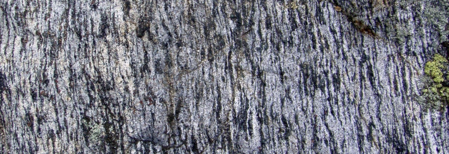
Mylonitic zones associated with the ZCzen mainly affect lithologies of the Zeni Complex.
Structural Characteristics
The ZCzen consists of several protomylonitic to mylonitic zones between which units are affected by strong planar and linear deformation.
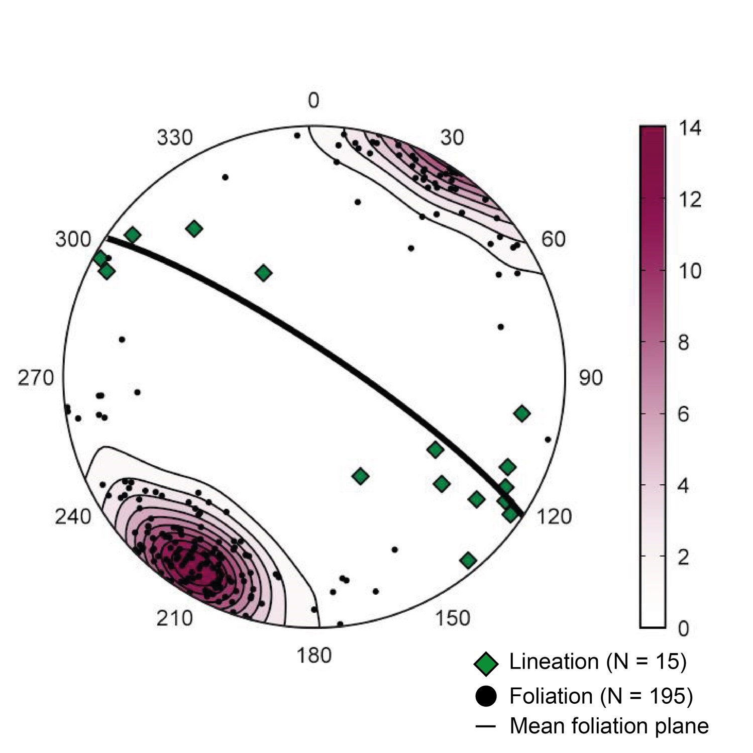
❯ Main Fabrics
| Main Fabric | Type of Fabric | Direction (°) | Dip / Plunge (°) | Number of measurements | Comments |
| Foliation Sn | Foliation, gneissosity, mylonitic foliation or banding, schistosity | 304 | 81 | 195 | |
| Lineation Ln | Lineation | 125 | 10 | 15 |
|
❯ Other Fabrics
Not observed.
❯ Folds
Not observed.
❯ Cross-Cutting Relationships
The Adelaide Fault is a branch south of the ZCzen that deforms an amphibolite strip of the Zeni Complex, in addition to separate orthogneiss of the Elson Complex in the west from those of the Jannière Complex in the east. Its presence and trace were inferred by Hammouche et al. (2012) from the geophysical survey. According to magnetic lineaments, the Adelaide Fault is cut by the ZCzen and ZCrge. The ZCzen is itself cut to the west by the ZCrge; at this location, positive magnetic anomalies corresponding to the Zeni Complex are also shifted according to a dextral movement.
Geometric Parameters of the Adelaide Fault:
| Fault or Family of Faults | Type | Mean Direction (°) | Mean Dip (°) | Lineation Plunge in the Fault Plane | Estimated Width (m) | Estimated Length (km) | Apparent Movement | Position | Comments |
| Adelaide Fault | Shearing | N-S | Undetermined | Undetermined | Undetermined | 20 | Undetermined | Uncertain, deduced from geophysical survey |
❯ Kinematics
The only kinematic indicators observed are sigma-type feldspar porphyroclasts. They indicate dextral horizontal movement (Hammouche et al., 2012).
Deformation Style
The intensity of deformation within the ZCzen is variable, moving from zones with little deformation to mylonites.
Metamorphic Characteristics
ZCzen rocks have been affected by granulite facies metamorphism (Taner, 1992; Hammouche et al., 2012). Taner (1992) observed pyroxenes having undulatory extinction that indicate that deformation is postmetamorphism. Silification and hematitization are superimposed on protomylonitic fabrics near the contact between the Zeni and Jannière complexes.
Alterations
Not observed.
Geophysical Characteristics
The ZCzen corresponds to a succession of ESE-WNW linear magnetic ridges. The high magnetic susceptibility of this shear zone is attributed to amphibolites and tonalitic to granitic mylonites of the Zeni Complex. The closely alternating magnetic ridges are caused by high transposition of geological contacts parallel to the main shear foliation. Interpretation of geophysical maps also indicates that the ZCzen is truncated by the ZCrge (Vanier et al., 2018).
Chronological Markers
The ZCzen deformation is later than 2480 Ma, the crystallization age of a mylonitized felsic rock of the Zeni Complex (David et al., 2009), and prior to the ZCrge deformation, which ended around 1825 Ma (Dunphy and Skulski, 1996).
References
Publications available through Sigéom Examine
DAVID, J., MOUKHSIL, A., CLARK, T., HEBERT, C., NANTEL, S., DION, C., SAPPIN, A A. 2009. DATATIONS U-PB EFFECTUEES DANS LES PROVINCES DE GRENVILLE ET DE CHURCHILL EN 2006-2007. GEOTOP UQAM-MCGILL, UNIVERSITE LAVAL, MRNF. RP 2009-03, 32 pages.
HAMMOUCHE, H., LEGOUIX, C., GOUTIER, J., DION, C. 2012. GEOLOGIE DE LA REGION DU LAC ZENI. MRN. RG 2012-02, 35 pages and 1 plan.
HAMMOUCHE, H., LEGOUIX, C., GOUTIER, J., DION, C., PETRELLA, L. 2011. GEOLOGIE DE LA REGION DU LAC BONAVENTURE. MRNF. RG 2011-03, 37 pages and 1 plan.
TANER, M F. 1987. RECONNAISSANCE GEOLOGIQUE DE LA REGION DU LAC JUILLET - NOUVEAU-QUEBEC -. MRN. DP-87-11, 23 pages and 7 plans.
TANER, M F. 1992. RECONNAISSANCE GEOLOGIQUE DE LA REGION DU LAC JUILLET - TERRITOIRE DU NOUVEAU-QUEBEC -. MRN. MB 91-19, 132 pages and 7 plans.
VANIER, M.-A., GODET, A., GUILMETTE, C., HARRIS, L B., CLEVEN, N R., CHARETTE, B., LAFRANCE, I. 2018. Extrusion latérale en croûte moyenne dans le sud-est de la Province de Churchill démontrée par les interprétations géophysiques, l'analyse structurale et les pétrofabriques du quartz. UNIVERSITE LAVAL, INRS, MERN. MB 2018-12, 58 pages.
Other publications
Dunphy, J.M., Skulski, T. 1996. Petrological zonation across the De Pas Batholith: a tilted section through a continental arc? In Eastern Canadian Shield Onshore-Offshore (ECSOOT) Transect Meeting, 1996 (Wardle, R.J. and Hall, J., editors). The University of British Columbia, Lithoprobe Secretariat; Report, 57, pages 44-58.
Vollmer, F.W. 1995. C program for automatic contouring of spherical orientation data using a modified Kamb method. Computers and Geosciences; volume 21, pages 31-49. doi.org/10.1016/0098-3004(94)00058-3