

Last modification:
| Author(s) | Van der Leeden et al., 1985 |
| Methodology | Defined from a geological survey and geophysical data |
| Belonging | Churchill Province / George, Mistinibi-Raude and Falcoz lithotectonic domains |
| Main movement | Dextral |
| Deformation style | Anastomosed |
| Metamorphic facies (mean facies related to main deformation) | Amphibolites |
Background and Methodology
Van der Leeden (1985, 1994, 1995) first identified significant shear zones along the George River, in the area where it widened to become the Hutte Sauvage Lake (NTS sheet 23P15), in the SE Quebec portion of the Southeastern Churchill Province (SECP). He associates these shear zones with a major regional structure called the Rivière George Shear Zone (ZCrge). The length of its N-S extension is then estimated at >200 km based on aeromagnetic surveys. Indeed, these shear zones have been recognized southward to the Quebec-Labrador boundary (Owen, 1989; Danis, 1991; Tanner, 1992; Hammouche et al., 2011) and northward to Ungava Bay (Girard, 1990; Simard et al., 2013; Lafrance et al., 2014, 2015, 2016). Gravity (Telmat et al., 1999), geochronology (Dunphy and Skulski, 1996; Isnard et al., 1998) and geology (Bardoux et al., 1998) work carried out on the edge of Ungava Bay, as part of the Lithoprobe project, also helped define the zone of influence of the deformation zone, its characteristics and its relationship to other major structures of the SECP.
This structural record is based on all of the previous work cited above. Structural measurements used in stereograms come from geological surveys conducted by the Ministère between 2009 and 2015 at 1:250 000 and 1:50 000 scales. The regional structural grain, as well as the ZCrge influence zone, was determined by combining field observations with aeromagnetic surveys (D’Amours and Intissar, 2012a, b, 2013; Intissar et al., 2014). A detailed structural study of the ZCrge was also conducted as part of a master’s thesis (Vanier et al., 2017, 2018).
Boundaries and Morphology
| Width | 15 km (average); 26 km (maximum) |
| Length | 435 km |
| Orientation | N-S to NNW-SSE |
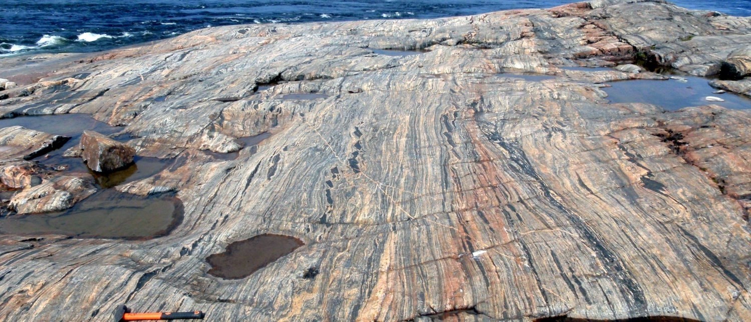
The ZCrge is a regional structure grouping an anastomosed network of sheared rock within which metric layers less deformed are inserted. This structure crosses the entire SECP. It marks the eastern boundary of the George Lithotectonic Domain (Charette et al., 2018) with the Falcoz and Mistinibi-Raude domains (Lafrance et al., 2019) to the NE and SE respectively. The anastomosed morphology, in addition to the NNW-SSE deflection occurring at the junction of the Moonbase Shear Zone (ZCmob), naturally divides the ZCrge into three branches: 1) a NNW-SSE oriented northern branch; 2) a N-S oriented southern branch; and, 3) a N-S oriented central branch surrounding a less deformed zone. The latter corresponds largely to the Brégent Shear Zone defined by Lafrance et al. (2016). The ZCrge various branches are located on the total residual magnetic field figure shown below in the “geophysical characteristics” section.
Stratigraphic Units Concerned
All units of the George Lithotectonic Domain were affected by the deformation. These are thinned and fully transposed in the N-S mylonitic foliation (van der Leeden et al., 1990; Lafrance et al., 2015). Mylonitic deformation affects both Paleoproterozoic rocks of the De Pas Supersuite and Archean to Paleoproterozoic units (Tunulic, Saint-Sauveur and Guesnier complexes). However, the De Pas units are not systematically affected by this deformation, indicating a syntectonic to late-tectonic emplacement in relation to the ZCrge.
In the case of the Falcoz and Mistinibi-Raude lithotectonic domains, only the bordering units were affected. These include the Siimitalik Suite, and Fougeraye and Kangiqsualujjuaq complexes, for the Falcoz Domain, and the Nekuashu and Déat suites, and Advance, Elson, Zeni and Mistinibi complexes, for the Mistinibi-Raude Domain.
Structural Characteristics
❯ Main Fabrics
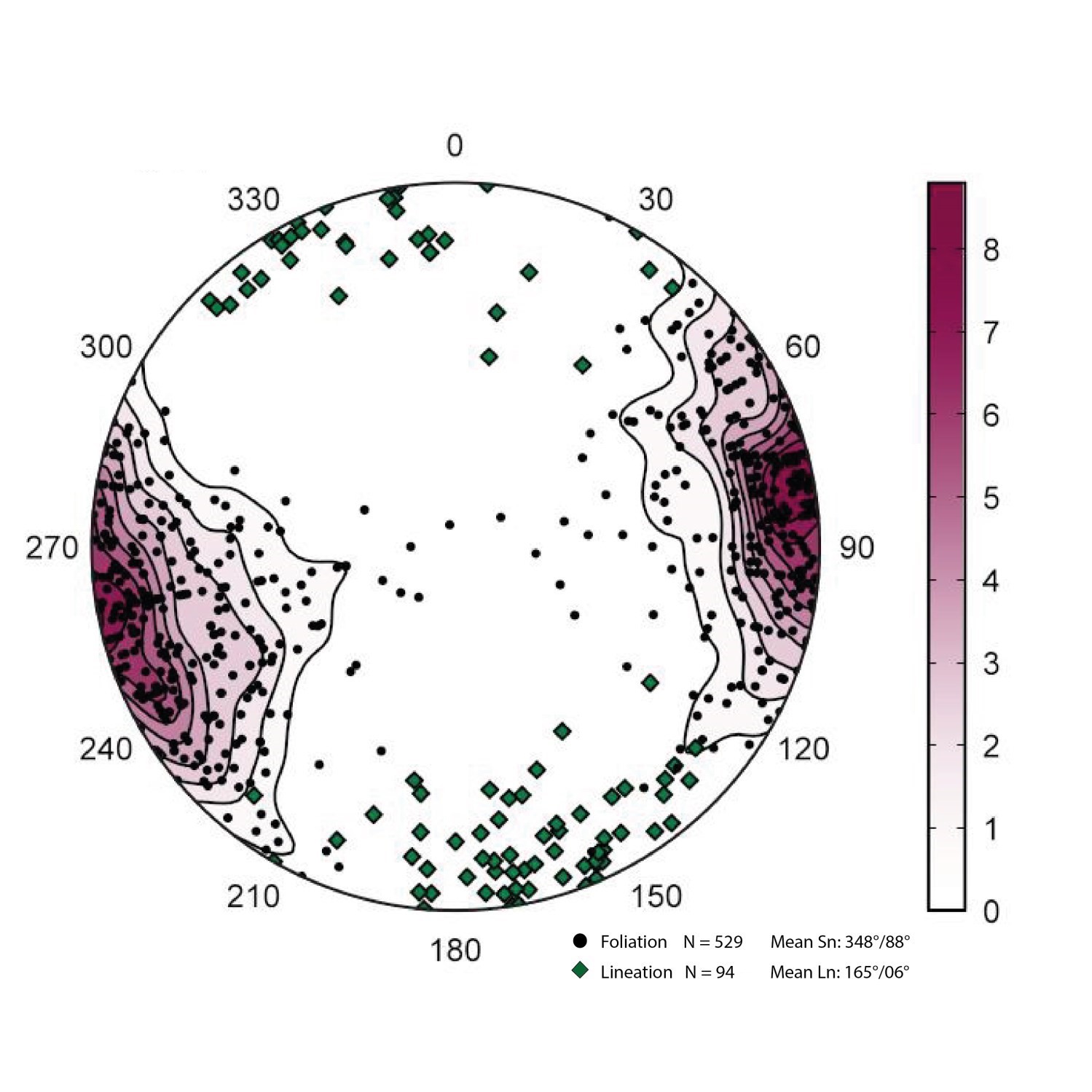
Mylonitic rocks are marked by a main shear surface whose orientation is the same as secondary tectonometamorphic foliations and gneissosities measured on less deformed outcrops. As a result, planar fabrics are here grouped into one family (Sn). The latter commonly contains a secondary tectonometamorphic mineral lineation or stretching lineation (Ln). Given the size of the shear zone, stereograms were constructed according to the subdivisions presented in the “Limits and morphology” section. Shear planes for the entire shear zone are steep, 70° to 90°. Lineations rather have shallow plunges, that is <25° on average, in a SE direction. However, sparse lineations have a steeper plunge around 45°.
| Main Fabrics | Type of Fabric | Direction (°) | Dip / Plunge (°) | Number of Measurements | Comments |
| Foliation Sn - Northern ZCrge | Foliation, gneissosity, foliation or mylonitic banding, schistosity | 326 | 83 | 330 | |
| Linéation Ln - Northern ZCrge | Lineation | 146 | 07 | 20 | |
| Foliation Sn - Central ZCrge | Foliation, foliation or mylonitic banding, gneissosity | 326 | 85 | 199 | |
| Linéation Ln - Central ZCrge | Lineation | 149 | 02 | 25 | |
| Foliation Sn - Southern ZCrge | Foliation, foliation or mylonitic banding, gneissosity, schistosity | 348 | 88 | 529 | |
| Linéation Ln - Southern ZCrge | Lineation | 165 | 06 | 94 |
Given the heterogeneous distribution of deformation and the presence of syntectonic to post-tectonic intrusions, there are significant variations in the deformation intensity within the ZCrge. In addition, deformation is expressed differently in different protoliths. The main facies are ultramylonites, porphyroclastic mylonites and orthogneiss.

The most deformed rocks are ultramylonites composed of very dark grey crushed material, whose protoliths are no longer recognizable. These rocks represent only centimetric to decimetric layers; they gradually evolve to mylonites containing mildly deformed subhedral feldspars in a matrix similar to ultramylonites.
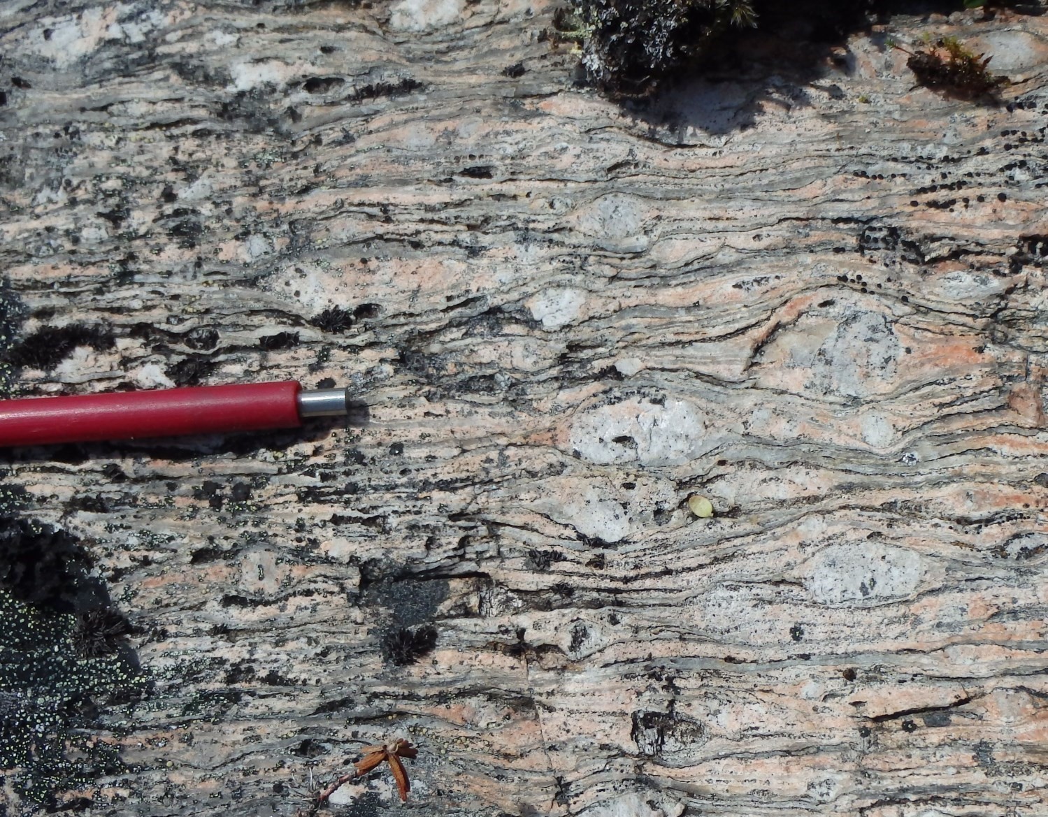

K-feldspar porphyroclastic orthomylonites having a matrix of crushed feldspar and millimetric quartz bands are common; they correspond mainly to sheared edges of the De Pas Granitic Suite. In some more deformed zones, grinding and mineral segregation generate alternating quartz and feldspar bands containing few feldspar porphyroclasts. The deformation is more diffuse in gneissic rocks of the Saint-Sauveur Complex and volcaniclastics of the Tunulic Complex. Highly straight-lined and locally porphyroclastic textures are dominant and resemble upright gneiss. Stretch lineations are present in all of these facies and can be significantly more pronounced than the planar fabric containing it (L>S and L>S tectonites). Stretching is mainly marked by quartz and feldspar porphyroclasts. Analysis of quartz c-axes also indicates widespread constrictive deformation in the ZCrge (Vanier et al., 2018).
❯ Other Fabrics
Does not apply.
❯ Folds
Z-folds are locally observed in mylonites which, in association with C/S structures, indicate dextral movement. Isoclinal folds and intrafolial folds are regularly observed in different units affected by the ZCrge.
❯ Cross-Cutting Relationships
Geophysical lineaments of the Zeni Shear Zone (ZCzen) are oriented E-W, while those of the ZCrge are N-S. The latter are parallel to foliation traces. The interpretation of aeromagnetic lineaments reveals a N-S discontinuity that cuts or deflects the structural grain of the ZCzen in a dextral manner (Vanier et al., 2018). Thus, the ZCrge is cutting the ZCzen. As for the ZCmob, it continuously joins the central section of the ZCrge to form a conjugate shear system (Vanier et al., 2018; see the “Deformation Style” section below).
❯ Kinematics
The ZCrge is dominated by dextral kinematic indicators; however, several sinistral indicators have also been observed at different locations (van der Leeden, 1990). Girard (1990) gave it a main dextral movement based on the reorientation of the regional structural grain and the offset of reference lithological assemblages. Near Ungava Bay, the ZCrge would also show dextral movement combined with eastward normal displacement (Bardoux et al., 1998).
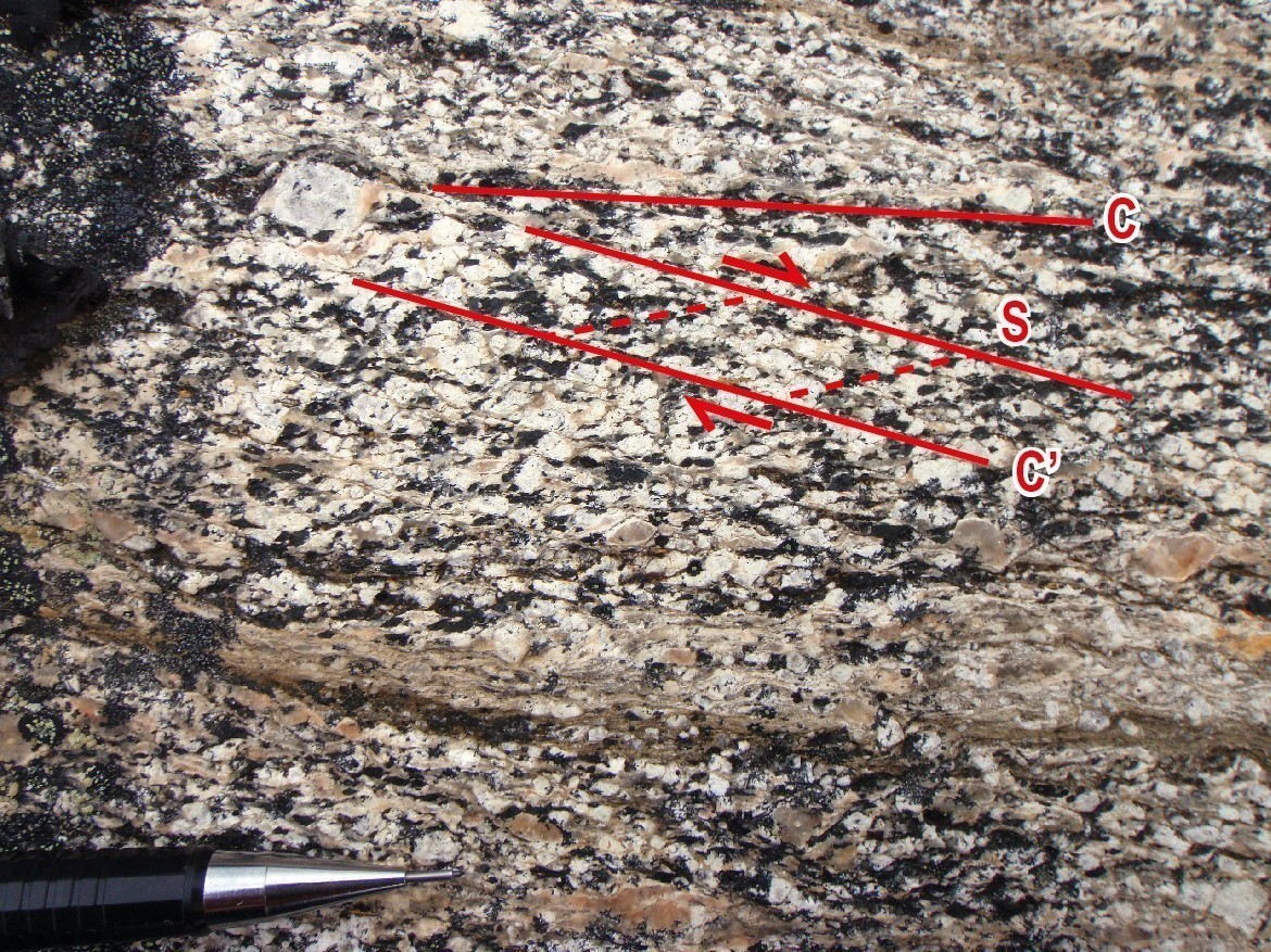
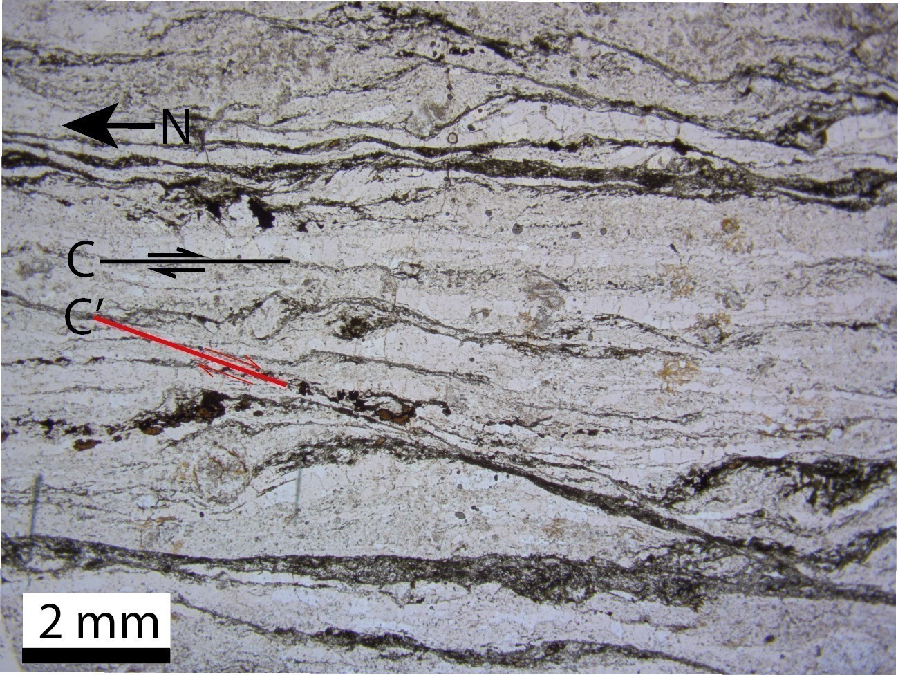
Porphyroclastic mylonites best express kinematics. They regularly contain C’, CS or both structures and sigmoidal porphyroclasts. Dextral C’ structures are also visible at the microscopic scale in even-grained and fine-grained rocks. The dextral movement is also confirmed by quartz c-axis fabrics (Vanier et al., 2018). Several sinistral kinematic indicators are also present. An explanation for the presence of antithetic kinematic indicators was provided by Charette et al. (2018). Ambiguous kinematics, such as when porphyroclasts are symmetrical, are also observed on many outcrops.
Deformation Style
The ZCrge is a complex shear zone whose anastomosed shape delineates, on a regional scale, less deformed blocks. This deformation style is also observed at the hectometre scale, where the deformation intensity is heterogeneous, creating alternating mylonites and foliated to little deformed rocks. In addition, the ZCmob joins the ZCrge in a diffuse manner, forming a conjugate ductile shear system (Vanier et al., 2018). The stress regime that produced this shear system consists of shortening along a SW-NE axis. In this context, the ZCrge consists of a dextral transpressive shear zone in medium crust condition (Vanier et al., in preparation).
Metamorphic Characteristics

The study of quartz and feldspar dynamic recrystallization textures and analysis of quartz c-axis indicates that the main deformation occurred at temperatures between 500°C and 700°C (Vanier et al., 2018). Indeed, the quartz predominant mechanism of dynamic recrystallization is grain edge migration. This type of dynamic recrystallization is associated with deformation above 500°C (Passchier and Trouw, 2005). Metamorphic assemblages of ZCrge rocks also correspond to the amphibolite facies. Metamorphic minerals, such as micas (mainly biotite), amphiboles and more locally sillimanite, are oriented in the mylonitic fabric. Thus, the main deformation is concomitant or slightly posterior to the peak of metamorphism. Biotite is commonly partially chloritized in volcanic rocks of the Tunulic Complex, indicating greenschist facies retrogressive metamorphism within and near highly sheared zones.
Alterations
Epidotization and pinkish-coloured hematitization are common in several units affected by the ZCrge.
Geophysical Characteristics
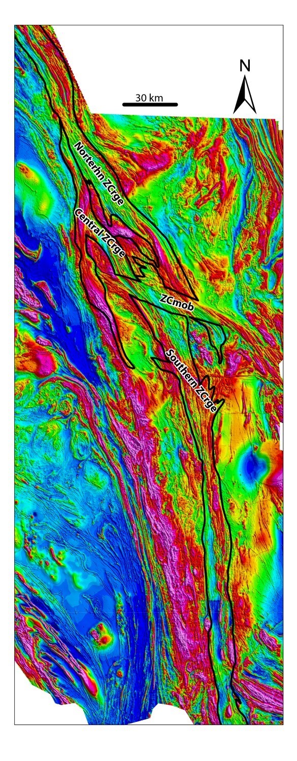
The various branches of the ZCrge correspond to well-defined straight-lined aeromagnetic lineaments, characterized by tightly alternating maximums and minimums of magnetic susceptibility. These lineaments are parallel to the main mylonitic foliation. This pattern is the result of a complete transposition of lithostratigraphic units. Zones with lower deformation intensity are associated with a disorganized aeromagnetic pattern similar to undeformed portions of the De Pas Supersuite adjacent to the ZCrge (mostly to the west). The interpretation of lineaments also indicates dextral offsetting of the ZCzen and Zeni Complex by the ZCrge (Vanier et al., 2018).
Chronological Markers
The most useful geological unit to constrain the ZCrge temporally is the De Pas Supersuite. It has both ultramylonitic textures and massive, undeformed intrusions cutting the main fabrics, attesting to the syntectonic to post-tectonic character of this unit. Crystallization ages of the De Pas Supersuite range from 1805 Ma to 1862 Ma, which does not contradict the final estimated age of deformation is 1800 Ma as reported by Isnard et al. (1998) and Bardoux et al. (1998).
Dating of a slightly foliated granodiorite cutting mylonitic granite helps to more precisely constrain deformation. The resulting crystallization age (1825 ±2 Ma; Dunphy and Skulski, 1996) is interpreted by the authors as indicating a deformation that is still active at this time, but significantly less intense.
References
Publications available through Sigéom Examine
CHARRETTE, B., LAFRANCE, I., VANIER, M.-A. 2018. Domaine lithotectonique de George, sud-est de la Province de Churchill, Nunavik, Québec, Canada : synthèse de la géologie. MERN. BG 2018-11
CHARRETTE, B., LAFRANCE, I., VANIER, MA., GODET, A. 2019. Domaine lithotectonique de Mistinibi-Raude, sud-est de la Province de Churchill, Nunavik, Québec, Canada : synthèse de la géologie. MERN. BG 2019-07, 1 plan.
CLARK, T., WARES, R. 2004. SYNTHESE LITHOTECTONIQUE ET METALLOGENIQUE DE L'OROGENE DU NOUVEAU-QUEBEC (FOSSE DU LABRADOR). MRNFP. MM 2004-01, 182 pages and 1 plan.
D'AMOURS, I., INTISSAR, R. 2012. LEVE MAGNETIQUE ET SPECTROMETRIQUE AEROPORTE DANS LE SECTEUR DU LAC LE MOYNE, PROVINCE DE CHURCHILL. MRNF. DP 2011-06, 8 pages and 200 plans.
D'AMOURS, I., INTISSAR, R. 2012. LEVE MAGNETIQUE ET SPECTROMETRIQUE AEROPORTE DE LA RIVIERE KOKSOAK, PROVINCE DE CHURCHILL. MRNF. DP 2011-07, 8 pages and 180 plans.
D'AMOURS, I., INTISSAR, R. 2013. LEVE MAGNETIQUE ET SPECTROMETRIQUE AEROPORTE DANS LE SECTEUR DE LA RIVIERE A LA BALEINE, PROVINCE DE CHURCHILL. MRN. DP 2013-03, 10 pages and 170 plans.
DANIS, D. 1991. GEOLOGIE DE LA REGION DU LAC RAUDE (TERRITOIRE-DU-NOUVEAU-QUEBEC). MRN. ET 88-10, 73 pages and 5 plans.
HAMMOUCHE, H., LEGOUIX, C., GOUTIER, J., DION, C., PETRELLA, L. 2011. GEOLOGIE DE LA REGION DU LAC BONAVENTURE. MRNF. RG 2011-03, 37 pages and 1 plan.
INTISSAR, R., BENAHMED, S., D'AMOURS, I. 2014. LEVE MAGNETIQUE ET SPECTROMETRIQUE AEROPORTE DANS LE SECTEUR NORD DE LA RIVIERE GEORGE, PARTIE SUD-EST DE LA PROVINCE DE CHURCHILL. MRN. DP 2014-02, 9 pages and 160 plans.
Lafrance, I., Charette, B., Vanier, M.-A., 2018. Sud-est de la Province de Churchill, Nunavik, Québec, Canada : synthèse de la géologie. MERN. Bulletin géologiQUE
LAFRANCE, I., BANDYAYERA, D., BILODEAU, C. 2015. GEOLOGIE DE LA REGION DU LAC HENRIETTA (SNRC 24H). MERN. RG 2015-01, 62 pages and 1 plan.
LAFRANCE, I., BANDYAYERA, D., CHARETTE, B., BILODEAU, C., DAVID, J. 2016. GEOLOGIE DE LA REGION DU LAC BRISSON (SNRC 24A). MERN. RG 2015-05, 64 pages and 1 plan.
LAFRANCE, I., SIMARD, M., BANDYAYERA, D. 2014. GEOLOGIE DE LA REGION DU LAC SAFFRAY (SNRC 24F, 24G). MRN. RG 2014-02, 51 pages and 1 plan.
OWEN, J V. 1989. GEOLOGIE DE LA REGION DU LAC LEIF (TERRITOIRE DU NOUVEAU-QUEBEC). MRN. ET 87-18, 56 pages and 3 plans.
SIMARD, M., LAFRANCE, I., HAMMOUCHE, H., LEGOUIX, C. 2013. GEOLOGIE DE LA REGION DE KUUJJUAQ ET DE LA BAIE D'UNGAVA (SNRC 24J, 24K). MRN. RG 2013-04, 62 pages and 1 plan.
TANER, M F. 1992. RECONNAISSANCE GEOLOGIQUE DE LA REGION DU LAC JUILLET - TERRITOIRE DU NOUVEAU-QUEBEC - MRN. MB 91-19, 132 pages and 7 plans.
VAN DER LEEDEN, J. 1985. RAPPORTS D'ACTIVITE 1985 - DIRECTION DE LA RECHERCHE GEOLOGIQUE. M E R. DV 85-12, 91 pages.
VAN DER LEEDEN, J. 1994. GEOLOGIE DE LA REGION DU LAC DE LA HUTTE SAUVAGE (TERRITOIRE DU NOUVEAU-QUEBEC). MRN. MB 94-32, 109 pages and 2 plans.
VAN DER LEEDEN, J. 1995. GEOLOGIE DE LA REGION DU LAC MISTINIBI (TERRITOIRE DU NOUVEAU-QUEBEC). MRN. MB 95-45, 107 pages and 3 plans.
VANIER, M.-A., GODET, A., GUILMETTE, C., HARRIS, L B., CLEVEN, N R., CHARETTE, B., LAFRANCE, I. 2018. Extrusion latérale en croûte moyenne dans le sud-est de la Province de Churchill démontrée par les interprétations géophysiques, l'analyse structurale et les pétrofabriques du quartz. UNIVERSITE LAVAL, INRS, MERN. MB 2018-12, 58 pages.
VANIER, M.-A., GUILMETTE, C., HARRIS, L., GODET, A., CLEVEN, N., CHARETTE, B., LAFRANCE, I. 2017. ANALYSE STRUCTURALE ET MICROSTRUCTURES DES ZONES DE CISAILLEMENT DE LA RIVIERE GEORGE ET DU LAC TUDOR. UNIVERSITE LAVAL, INRS, MERN. MB 2017-12, 50 pages.
Other publications
BARDOUX, M., DIGONNET, S., DONOHUE, L., GIARD, B., ROBILLARD, M., DAVID, J., PARENT, M., GARIÉPY, C. 1998. Paloeproterozoic tectonics affecting archean lower crust of southern Ungav Bay. Eastern canadian shield onshore-offshore transect (ECSOOT), volume 68, pages 1-17.
DUNPHY, J.M., SKULSKI, T. 1996. Petrological zonation across the De Pas Batholith: a tilted section through a continental arc? In Eastern Canadian Shield Onshore–Offshore (ECSOOT) Transect Meeting 1996 (Wardle R.J. and Hall, J., editors). The University of British Columbia, Lithoprobe Secretariat; Report 57, pages 44-58.
GIRARD, R. 1990. Les cisaillements latéraux dans l’arrière-pays des orogènes du Nouveau-Québec et de Torngat : une revue. Geoscience Canada; volume 17, pages 301-304.
ISNARD, H., PARENT, M., BARDOUX, M., DAVID, J., GARIÉPY, C., STEVENSON, R.K. 1998. U-Pb, Sm–Nd and Pb-Pb isotope geochemistry of the high-grade gneiss assemblages along the southern shore of Ungava Bay. In Eastern Canadian Shield Onshore–Offshore (ECSOOT), Transect Meeting, 1998 (Wardle R.J.and Hall, J., editors). The University of British Columbia, Lithoprobe Secretariat; Report 68, pages 67-77.
TELMAT, H., MARESCHAL, J.-C., GARIÉPY, C. 1999. The gravity field over the Ungava Bay region from satellite altimetry and new land-based data: implications for the geology of the area. Canadian Journal of Earth Sciences; volume 36, pages 75-89. doi.org/10.1139/e98-085
VAN DER LEEDEN, J., BELANGER, M., DANIS, D., GIRARD, R., MARTELAIN, J. 1990. Lithotectonic domains in the high-grade terrain east of the Labrador Trough (Quebec). In The Early Proterozoic Trans-Hudson Orogen (J.F. Lewry and M.R. Stauffer, editors). Geological Association of Canada; Special Paper 37, pages 371-386.
VOLLMER, F.W. 1995. C program for automatic contouring of spherical orientation data using a modified Kamb method: Computers & Geosciences; volume 21, pages 31-49. doi.org/10.1016/0098-3004(94)00058-3