

Last modified: 22 mars 2023
Background
Van der Leeden et al. (1990) proposed different tectonic subdivisions for the Southeastern Churchill Province (SECP). The current boundaries of the George Lithotectonic Domain (see the Churchill Province for domain location) approximately corresponds to the Rivière George Shear Zone and De Pas domains combined. These latter divisions were used by Wardle et al. (1990a). In the south of the SECP, this area corresponds largely to the Crossroad Domain. This nomenclature has been used by several authors (Kerr et al., 1994; James et al., 1996; James and Dunning, 2000; Hammouche et al., 2011). Other authors have also used the terms Central Zone (James and Mahoney, 1994), Central Gneissic Zone (Wardle et al., 1990b) and George River Tectonic Zone (Bardoux et al., 1998), referring to the area mostly represented by the George Domain.
Since then, the domain’s boundaries have been refined regionally through geological surveys and studies conducted by the Ministère and its partners between 2009 and 2017. Corrigan et al. (2018) named the current George Domain the « George River Block », but included the northern part of the Baleine Lithotectonic Domain. The George Lithotectonic Domain’s boundaries, as presented here, have been redefined as part of the SECP synthesis (Lafrance et al., 2018).
Description
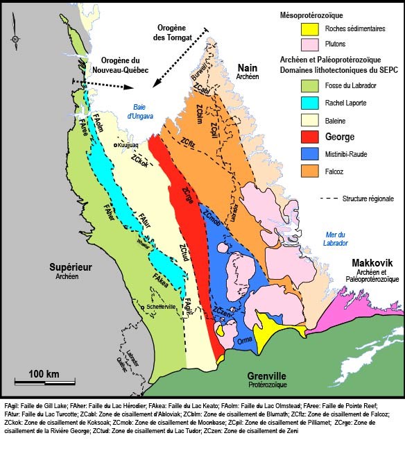 The George Lithotectonic Domain is located in the central part of the SECP and is 445 km long by 30 to 60 km wide, for a total surface area of ~19,950 km2. It is oriented NNW-SSE in the northern part of the SECP, beginning at the Ungava Bay, and gradually changes to a N-S orientation southward up to the Labrador border. It is limited to the west by the Baleine Lithotectonic Domain, with which it is in fault contact in the southern part of the SECP (Lac Tudor Shear Zone). In the northern area, the contact is more arbitrarily defined and locally masked by the presence of large zones of late-tectonic intrusion. On the east side, the George Domain is in contact with two lithotectonic domains, namely Falcoz to the NE, and Mistinibi-Raude to the SE. The contact with these domains coincides with the Rivière George Shear Zone (ZCrge).
Geology
The George Lithotectonic Domain consists of gneissic bedrock (Saint-Sauveur Complex) and volcano-sedimentary klippes (Tunulic Complex) of Archean age. Gneiss displays evidence of partial melting, namely the presence of banded migmatitic rocks and, in some places, anatectic granite (Guesnier Complex). These units are cut by Paleoproterozoic intrusions, particularly those of the De Pas Supersuite, which occupy a large area within the George Domain. All of these units are generally highly deformed and dissected by the ZCrge. Only the late and sparse phases of the De Pas Supersuite, Fayot Suite and Mesoproterozoic dyke swarms are little or not deformed.
Rocks of the George Lithotectonic Domain have been grouped into different lithodemic units, mainly suites and complexes, according to the North American Stratigraphic Code (Ministère de l’Énergie et des Ressources, 1986; American Commission on Stratigraphic Nomenclature, 2005; Easton, 2009) and taking into account the nomenclature already established. These units were defined based on available geological and geochronological data. The stratigraphic order is shown on the geological map of Charette et al. (2018) and in the table below, from the youngest to the oldest unit.
| MESOPROTEROZOIC | ||
| mPsip | Slippery Dykes | Subophitic, massive and medium-grained olivine gabbro |
| mPhar | Harp Dykes | Ophitic and massive olivine gabbro |
| mPfal | Falcoz Swarm | Subophitic, massive and fine-grained olivine gabbro and olivine gabbronorite |
| PALEOPROTEROZOIC | ||
| pPfay | Fayot Suite | Massive melanocratic (minette) and leucocratic (vogesite) lamprophyres |
| De Pas Supersuite | ||
| pPbon | Bonaventure Pluton | Massive and homogeneous gabbronorite |
| pPcde | De Pas Charnockitic Suite | Opdalite, jotunite and mangerite ± porphyroids; leucocratic mafic intrusive rocks and diorite |
| pPmer | Merville Pluton | Massive biotite-hornblende diorite |
| pPdep | De Pas Granitic Suite | Granodiorite and quartz monzodiorite ± porphyroids; granite |
| ARCHEAN AND PALEOPROTEROZOIC | ||
| nApPges | Guesnier Complex | Banded migmatite, tonalite and anatectic granite |
| nAtun | Tunulic Complex | Metavolcaniclastics, metabasalt, paragneiss, gabbro and ultramafic rocks |
| ApPgss | Saint-Sauveur Complex | Gneiss and tonalite |
Geological Evolution
The George Domain is characterized by a polyphase and complex tectonic evolution. The oldest rocks, which include the Saint-Sauveur, Guesnier and Tunulic complexes, appear to be mostly Neoarchean. However, since the only dating done in the Saint-Sauveur Complex is from a homogeneous tonalite and not from a gneiss, it is very likely that the emplacement of this unit span over a longer period of time, as is the case for the similarly composed gneissic units observed in the rest of the SECP (Ungava and Kangiqsualujjuaq complexes). Indeed, the presence of Mesoarchean inherited zircons in a migmatite sample of the Guesnier Complex tends to confirm this hypothesis. Melting of Saint-Sauveur Complex gneiss led to the formation of migmatite and anatectic granite of the Guesnier Complex. Geochronology indicates that migmatization took place around 2687 Ma, contemporary with the emplacement of Tunulic Complex volcano-sedimentary rocks. Instead, field observations suggest that the melting event behind migmatites would be much later and that the crystallization of melting products would have occurred during different phases of deformation, mainly during and after the main tectonic deformation in the George Domain. Archean ages could therefore be related to the presence of paleosome in the sample from which inherited zircons and progressive metamorphic zircons are more favourably preserved (Kelsey et al., 2008; Yakymchuk and Brown, 2014). However, metamorphic ages obtained on zircon overgrowth in a sample of the Tunulic Complex appear to confirm the presence of Neoarchean metamorphism between 2565 and 2543 Ma. The current data are thus not sufficient to confirm either of these hypotheses.
Following the emplacement of Archean units, no magmatic or tectonic activity was recorded in lithologies of the George Domain until the Trans-Hudsonian Orogeny. During this period of convergence, the geological evolution of this domain is mainly marked by a period of intense magmatic activity, which extends from ~1860 to 1800 Ma, as well as a long period of mylonitic deformation that is partly concurrent with it. These events produced the observed relationships between lithological units that indicate that Neoarchean to Paleoproterozoic units form large klippes, highly deformed and cut by intrusions of the De Pas Supersuite. Between theses klippes, De Pas intrusive rocks form mylonitized masses in places and, in other places, massive ones.
The stratigraphic diagram presented in Charette et al. (2018) shows initial relationships between the Neoarchean to Paleoproterozoic units, Paleoproterozoic intrusions and Mesoproterozoic dykes. Furthermore, the structural and regional tectonic interpretation presented in this bulletin supports the hypothesis that this domain was part of a large region with medium-orogenic crust shear shortening during the Trans-Hudsonian Orogen. The study of geophysics, quartz petrofabrics and George Domain’s structures suggests that regional deformation would have occurred while the bedrock (Neoarchean to Paleoproterozoic units) was buried under medium crust conditions, undergoing partial melting, and magmatism associated with the De Pas Supersuite was active (Vanier et al., 2018).
References
Publications Available Through SIGÉOM Examine
CHARETTE, B., LAFRANCE, I., VANIER, M.-A., 2018. Domaine lithotectonique de George, sud-est de la Province de Churchill, Nunavik, Québec, Canada : synthèse de la géologie. MERN; BG 2018-11, 2 plans.
HAMMOUCHE, H., LEGOUIX, C., GOUTIER, J., DION, C., PETRELLA, L., 2011. GEOLOGIE DE LA REGION DU LAC BONAVENTURE. MRNF; RG 2011-03, 37 pages, 1 plan.
LAFRANCE, I., CHARETTE, B., VANIER, M.-A., 2018. Sud-est de la Province de Churchill, Nunavik, Québec, Canada: synthèse de la géologie. MERN; BG 2018-12
N A C S N, 1986. CODE STRATIGRAPHIQUE NORD-AMERICAIN. DV 86-02, 76 pages.
VANIER, M.-A., GODET, A., GUILMETTE, C., HARRIS, L. B., CLEVEN, N. R., CHARETTE, B., LAFRANCE, I., 2018. Extrusion latérale en croûte moyenne dans le sud-est de la Province de Churchill démontrée par les interprétations géophysiques, l’analyse structurale et les pétrofabriques du quartz. UNIVERSITE LAVAL, INRS, MERN; MB 2018-12, 58 pages.
Other Publications
AMERICAN COMMISSION ON STRATIGRAPHIC NOMENCLATURE 2005. North American Stratigraphic Code. The American Association of Petroleum Geologist Bulletin; volume 89, pages 1547-1591. https://DOI:10.1306/07050504129
BARDOUX, M., DIGONNET, S., DONOHUE, L., GIRAD, B., ROBILLARD, M., DAVID, J., PARENT, M., GARIÉPY, C. 1998. Paleoproterozoic tectonics affecting Archean lower crust of southern Ungava Bay. In: Eastern Canadian Shield Onshore–Offshore Transect (ECSOOT), Report of the 1998 Transect Meeting. Compiled by RJ Wardle and J. Hall. The University of British Columbia, Lithoprobe Secretariat, Report, volume 68, pages 1-17.
CORRIGAN, D., WODICKA, N., McFARLANE, C.,, LAFRANCE, I., VAN ROOYEN, D., BANDYAYERA, D., BILODEAU, C. 2018. Lithotectonic framework of the Core Zone, Southeastern Churchill Province. Geoscience; volume 45, pages 1-24. https://doi.org/10.12789/geocanj.2018.45.128
EASTON, R.M. 2009. A guide to the application of lithostratigraphic terminology in Precambrian terrains. Stratigraphy; volume 6, pages 117-134. https://nacsn.americangeosciences.org/sites/default/files/2018-01/48689_articles_article_file_1643.pdf
JAMES, D.T., MAHONEY, K.L. 1994. Structural, Metamorphic and intrusive relations in the Hinterland of the Eastern Churchill Province, Western Labrador. Current Research, Newfoundland Department of Mines Ans Energy. Geological Survey Branch, Report 94-1, pages 371-385. https://www.gov.nl.ca/iet/files/mines-geoscience-publications-currentresearch-1994-james.pdf
JAMES, D.T., DUNNING, G.R. U-Pb 2000. geochronological constraints for Paleoproterozoic evolution of the Core Zone, southeastern Churchill Province, northeastern Laurentia. Precambrian Research; volume 103, pages 31-54. https://doi.org/10.1016/S0301-9268(00)00074-7
JAMES, D.T., CONNELLY, J.N., WASTENEYS, H.A., KILFOIL, G.J.1996. Paleoproterozoic lithotectonic divisions of the southeastern Churchill Province, western Labrador. Canadian Journal of Earth Sciences; volume 33, pages 216-230. https://doi.org/10.1139/e96-019
KELSEY, D.E., CLARK, C., HAND, M. 2008. Thermobarometric modelling of zircon and monazite growth in melt-bearing systems: examples using model metapelitic and metapsammitic granulites. Journal of Metamorphic Geology; volume 26, pages 199–212. https://doi.org/10.1111/j.1525-1314.2007.00757.x
KERR, A., JAMES, D.T., FRYER, B.J. 1994. Nd isotopic geochemical studies in the Labrador shield: a progress report Ans preliminary data from the Churchill (Rae) Province. Geological Survey of Newfoundland and Labrador, Department of Natural Resources, pages 51-61.
VAN DER LEEDEN, J., BELANGER, M., DANIS, D., GIRARD, R., MARTELAIN, J. 1990. Lithotectonic domains in the high-grade terrain east of the Labrador Trough (Quebec). In: The Early Proterozoic Trans-Hudson Orogen. Edited by J.F. Lewry and M.R. Stauffer. Geological Association of Canada; Special Paper 37, pages 371-386.
WARDLE, R.J., RYAN, B., ERMANOVICS, I. 1990a. The eastern Churchill Province, Torngat and New Québec orogens: An overview. Geoscience Canada; volume 17, numéro 4, pages 217-222. https://journals.lib.unb.ca/index.php/GC/article/view/3691/4205
WARDLE, R.J., RYAN, B., NUNN, G.A.G., MENGEL, F.C. 1990b. Labrador segment of the Trans-Hudson Orogen: crustal development through oblique convergence and collision. In: The Early Proterozoic Trans-Hudson Orogen of North America (J.F. Lewry and M.R. Stauffer, editors). Geological Association of Canada; Special Paper 37, pages 353-369.
YAKYMCHUK, C., BROWN, M. 2014. Behaviour of zircon and monazite during crustal melting. Journal of the Geological Society of London; volume 171, pages 465–479. https://doi.org/10.1144/jgs2013-115
Suggested Citation
Ministère des Ressources naturelles et des Forêts (MRNF). George Lithtectonic Domain. Quebec Structural Lexicon. https://gq.mines.gouv.qc.ca/lexique-stratigraphique/province-de-churchill/domaine-lithotectonique-de-george_en [accessed on Day Month Year].
Contributors
|
First publication |
Isabelle Lafrance, P. Geo., M.Sc. isabelle.lafrance@mern.gouv.qc.ca (redaction) Mehdi A. Guemache, P. Geo., Ph.D. (coordination); Patrice Roy, P. Geo., M. Sc. (critical review); Simon Auclair, P. Geo., M.Sc. (editing); Céline Dupuis, P. Geo., Ph.D. (English version ); Ricardo Escobar Moran (HTML editing). |