


The Southeastern Churchill Province (SECP) synthesis allowed for the defintion of boundaries within the George Lithotectonic Domain. A geological map and stratigraphic diagram of this domain are presented in this bulletin. The George Domain is dominated by intrusions of the De Pas Supersuite, which have a magmatic arc signature, but also includes migmatized gneissic bedrock and a large-scale volcano-sedimentary sequence. It represents a dextral transpressure zone where lithologies are affected by mylonitic deformation corridors forming an anastomosed network of shear zones developed under medium-crust metamorphic conditions. This geological context is an environment particularly prospective for orogenic gold and IOCG (Iron Oxide Copper Gold) mineralization.
Methodology
The George Lithotectonic Domain was mapped using the established method for surveys in isolated areas without road access. Geological mapping at scale 1:250 000 — covering most of the territory — was conducted by teams of seven to eight geologists and five to eight students during the summers of 2011 to 2014. Field checks were conducted in the southern portion of the domain in the summer of 2016 by a team of four geologists and three students. The Ministère’s previous mapping work in the southern portion of the domain has also been considered for data processing, including that conducted in the summers of 2009 and 2010.
The mapping and synthesis of the George Domain have produced and updated information presented in the opposite table.
| Element | Number |
|---|---|
| Described outcrop (“geofiche”) | 2550 |
| Total lithogeochemical analysis | 351 |
| Lithogeochemical analysis of metals of economic interest | 84 |
| Geochronological analysis | 17 |
| Covered thin section | 457 |
| Polished thin section | 9 |
| Sodium cobaltinitrite stain | 296 |
| Stratigraphic unit | 14 |
| Mineralization record | 25 |
Previous Work
The table below lists the work that has been done in the study area since 1896. It also includes the references cited in the report.
| Author(s) | Type of Work | Contribution |
|---|---|---|
| Low, 1896 | Geological reconnaissance | First geological survey work in the Southeastern Churchill Province |
| Taylor, 1979 | Large-scale regional geological mapping | First systematic geological mapping across the Churchill Province |
| Geological mapping at scale 1/50 000 | Geology of sheets 23I, 23P, 24A and 13M | |
| Geological mapping at scale 1/250 000 | Geology of sheets 23P, 24A, 24J, 24G and 24H | |
|
Wardle et al., 1990a; 1990b; Wardle et al., 2002; James and Mahoney, 1994; Kerr et al., 1994 Bardoux et al., 1988 |
Compilation, geological synthesis and geodynamic implications |
Context and geotectonic evolution of the SECP |
|
Machado et al., 1989; Isnard et al., 1998 Van der Leeden et al., 1990 |
Geochronology, synthesis and lithotectonic divisions | U-Pb dating of the George Domain in Quebec: De Pas Supersuite, Guesnier, Saint-Sauveur and Tunulic complexes, Fayot Suite |
|
Krogh, 1986 Dunphy and Skulski, 1996 |
Geochronology, synthesis and lithotectonic divisions | U-Pb dating in the George Domain’s extension in Labrador: De Pas Supersuite |
| Martelain et al., 1998 | Petrological and geochemical study | Characterizing the De Pas Supersuite |
| GDS, 2009; D’Amours and Intissar, 2013a, 2013b; Intissar et al., 2014; Intissar, 2018 | Geophysical surveys | Magnetic and spectrometric aerial surveys of most o the Southeastern Churchill Province |
Lithostratigraphy
The George Lithotectonic Domain is located in the central part of the Southeastern Churchill Province (SECP). This area is characterized by a polyphase and complex tectonic evolution that resulted in intense deformation and metamorphism of lithological units. The crystallization ages of oldest units (gneiss and volcano-sedimentary rocks) are mostly Neoarchean. These units are cut by Paleoproterozoic intrusions, including De Pas Supersuite units, which cover a large area within the George Domain. The major tectonometamorphic event characterizing the Churchill Province is linked to the Trans-Hudsonian Orogen (THO), which is highlighted in the SECP by the Torngat Orogen (1.89-1.81 Ga) on the eastern edge, and by the New Quebec Orogen (1.82-1.77 Ga) at its western limit. References to the emplacement time of major units and structures listed in this Geological Bulletin are always made in relation to the Torngat Orogenesis, the main tectonometamorphic imprint recognized in the George Lithotectonic Domain.
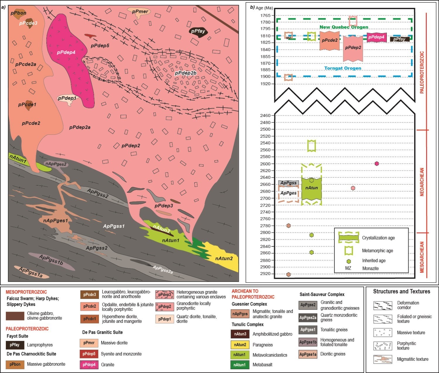
This section provides a summary description of lithostratigraphic units of the George Domain, including their geochemical characteristics. A more detailed description of these units, along with the associated geochronological data, is available in the Stratigraphic Lexicon (hyperlinks below). Units are presented based on the type of lithology and their relative chronology to regional deformation.
The simplified stratigraphic diagram shows the relationships between the different lithostratigraphic units in the domain in order to visualize their spatial and chronological arrangement. It is accompanied by a time scale that lists the age of units, determined from available U-Pb geochronological data, and crosscutting relationships observed in the field. The size of units shown in the diagram approximates the surface areas mapped. References associated with U-Pb dating of units are found in the George Domain map legend and in records of the stratigraphic lexicon. Ages were obtained from zircon analyses, with the exception of one monazite analysis identified on the timescale.
Gneissic Rocks
The Saint-Sauveur Complex (ApPgss) represents Neoarchean bedrock observed throughout the George Lithotectonic Domain. It consists mainly of a package of tonalitic gneiss (ApPgss1) and granodioritic to granitic gneiss (ApPgss2), each containing zones of intermediate composition (ApPgss1a and ApPgss2a). Zones of homogeneous tonalite (ApPgss1b) are also included into tonalitic gneiss. These would have been better preserved from deformation and partial melting than gneiss (Simard et al., 2013). The Neoarchean age given to the Saint-Sauveur Complex comes from a homogeneous tonalite sample, not from a gneiss. It is therefore very likely that emplacement of this unit took a longer period of time, as is the case for the similarly composed gneissic units observed in the rest of the SECP (Ungava and Kangiqsualujjuaq complexes). For this reason, the unit is indicated as Archean to Paleoproterozoic rather than Neoarchean to Paleoproterozoic. Saint-Sauveur Complex samples have trace element patterns typical of evolved rocks of the upper crust (see Lithogeochemistry).
The Guesnier Complex (nApPges) is a migmatite unit interpreted as being derived from partial melting of Saint-Sauveur Complex gneiss. The contact between these two units is gradual and poorly defined. Saint-Sauveur gneiss outcrops contain zones of migmatite and anatectic granite in varying proportions, while Guesnier migmatite may contain several gneiss enclaves and layers. Despite a Neoarchean age obtained in a Guesnier migmatite sample, field observations suggest that the melting event that generated migmatite is more pretectonic to syntectonic, and that crystallization of melting products is late-tectonic. Archean ages could therefore be related to the presence of paleosome in the sample. For this reason, the crystallization age range of the Guesnier Complex was represented in pink dotted lines on either side of the Saint-Sauveur Complex on the stratigraphic diagram. The presence of Mesoarchean inherited zircons in the Guesnier Complex tends to confirm the hypothesis that gneiss of the Saint-Sauveur Complex are partly older than Neoarchean. Current data are not sufficient to confirm the age of migmatization.
Supracrustal Rocks
The Tunulic Complex (nAtun) groups all metamorphosed volcano-sedimentary rocks and mafic and ultramafic intrusions of the George Lithotectonic Domain. It consists of metavolcaniclastics, felsic metavolcanics and metabasalt (nAtun1), banded paragneiss (nAtun2), gabbro (nAtun3) and ultramafic rocks (nAtun4). Volcanic rocks are Neoarchean and intrusive rocks are interpreted as dykes and sills contemporaneous to volcanism. Ages obtained in volcanics are mostly between 2698 Ma and 2648 Ma (full polygon on the stratigraphic diagram). However, in some samples, zircon populations analyzed show a large age distribution (dashed polygons) that could be explained by partial rejuvenation during metamorphism. Trace element profiles of mafic units suggest a tholeiitic to calc-alkaline arc setting with variable crustal contamination (see Lithogeochemistry).
Intrusive Rocks
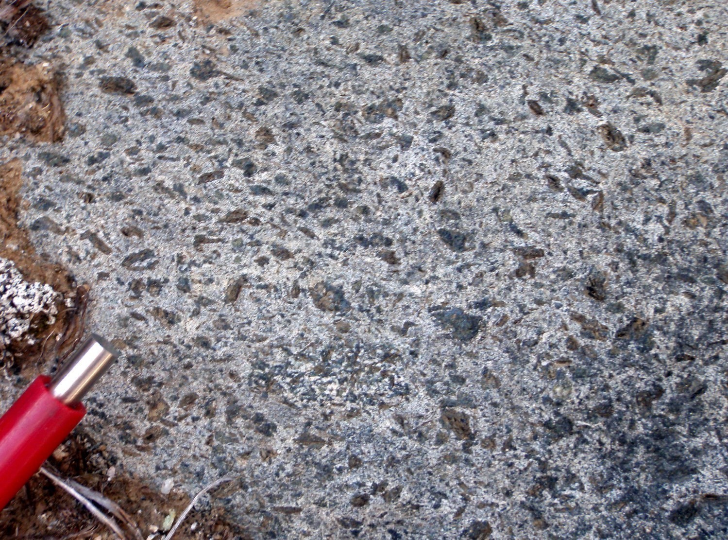
The De Pas Supersuite is a polyphase syntectonic intrusion that spans across the George Lithotectonic Domain in a NNW-SSE direction. Some De Pas intrusions are also present in the eastern part of the Baleine Lithotectonic Domain, directly to the west. The De Pas Supersuite is interpreted by several authors as being associated with a Proterozoic magmatic arc environment related to a subduction zone that developed during the New Quebec Orogenesis (Dunphy and Skulsky, 1996; Martelain et al., 1998; Simard et al., 2013). Wardle et al. (1990a, 2002) mention that it could also be associated with a syncollision component in the hinterland of the New Quebec Orogen. It consists of two suites: the De Pas Granitic Suite (pPdep) and the De Pas Charnockitic Suite (pPcde). In both cases, the main unit is granodiorite or quartz monzodiorite that commonly has a porphyraceous structure (pPdep2 and pPcde2). Minor units of mostly intermediate composition (pPPdep1, cPcde1, pPmer) are present in sharp or transitional contact with the main units of these suites. The edge of De Pas Granitic Suite contains very heterogeneous zones that contain up to 50% enclaves (pPdep3). Granodiorite of the De Pas Granitic Suite is cut by several foliated to massive potassic intrusive phases (pPdep4 and pPdep5). Also, small masses consisting mostly of massive to foliated gabbro and gabbronorite (pPcde3 and pPbon) are interpreted as late in the crystallization evolution of the De Pas Supersuite.
The contact between the granitic and charnockitic suites appears to be transitional. Several outcrops exhibit lithologies containing or not orthopyroxene that do not show any crosscutting relationships between them. A dominance of orthopyroxene units is observed in the southern portion of the supersuite, while they are absent from the northern portion. It is therefore possible that the southern portion of the De Pas Supersuite represents a deeper portion of the intrusion that allowed crystallization of orthopyroxene and formation of charnockite, whereas the northern portion would be a more superficial part. This transition from an orthopyroxene-bearing to a orthopyroxene-free rock could also reflect a change in crystallization conditions, with CO2-enriched magma changing laterally to a H2O-enriched magma. Orthopyroxene is well preserved in the SW portion of the George Lithotectonic Domain. As it moves northward, however, its degree of alteration increases until it is completely replaced by a mixture of serpentine and amphibole, followed by amphibole and biotite. This replacement could be explained by variations in pressure-temperature conditions or fluid composition as a result of crystallization of magmatic orthopyroxene.
Trace elements of De Pas Supersuite granitoid samples suggest a volcanic arc setting, as proposed by Martelain et al. (1998). All granitoids in the supersuite are Type-I and generally ranging from calc-alkaline to alkaline-calcic in affinity (see Lithogeochemistry).
The Fayot Suite (pPfay) is a limited-scale Paleoproterozoic unit that consists of five kilometric intrusions of massive lamprophyres. Fayot Suite sample profiles are comparable to those of an average alkaline lamprophyre (Rock, 1991; see Lithogeochemistry).
Mesoproterozoic Dykes
The entire SECP is cut by various swarms of mafic dykes, either ophitic or subophitic, grouped according to their emplacement’s orientation. Because of their Mesoproterozoic age, these dykes cut all other SECP units and exceed the limits of lithotectonic domains. Three dyke swarms were observed in the George Lithotectonic Domain.
The Harp Dykes (mPhar) include SECP olivine gabbros oriented NE-SW to ENE-WSW. Six dykes, from 3 to 12 km long and hectometre wide, were identified in the southern part of the George Domain.
The Slippery Dykes (mPsip) group SECP olivine gabbros and olivine gabbronorite oriented E-W to ENE-WSW. Two dykes, a few kilometres long and hectometre wide, were observed in the northern portion of the south third of the George Domain. Given their respective orientations, it is possible that the Harp and Slippery dykes belong to the same dyke swarm. However, the limited number of samples collected and geochemical data do not allow for the distinction of Slippery rocks as was the case with the Harp Dykes (three groups depending on certain geochemical characteristics). Therefore, these two units remain separate at this time.
The Falcoz Swarm (mPfal) groups SECP olivine gabbro dykes oriented NNW-SSE. Only one dyke, ~2 km long and 180 m wide, was assigned to this unit in the northern part of the George Domain.
Metamorphism
Metamorphism affecting the George Lithotectonic Domain occurred mainly in the Paleoproterozoic. It affects all of the Archean to Paleoproterozoic lithologies of this domain, whereas Paleoproterozoic lithologies are little to unmetamorphosed given their synorogenic to postorogenic crystallization with respect to the Torngat Orogenesis. Mesoproterozoic rocks of the Falcoz Swarm, and Slippery and Harp Dykes are unmetamorphosed. In the George Domain, a majority of U-Pb metamorphic ages obtained on zircon and monazite crystals are between 1800 Ma and 1830 Ma. A metamorphic age of 1901 ±36 Ma was obtained in a migmatite sample of the Guesnier Complex (pPges1) and is consistent with the preliminary Lu-Hf age obtained on garnets of a paragneiss from the False Suite in the Baleine Lithotectonic Domain (A. Godet, pers. comm.). Zircon overgrowth in a metarhyolite sample of the Tunulic Complex indicates that Archean metamorphism, around 2565 Ma (Jean David, pers. comm.) and 2543 Ma (Corrigan et al., 2018), has affected lithologies of this volcano-sedimentary belt.
Although no quantitative estimation of metamorphic conditions has been obtained in this domain, several field observations allow for the interpretation of metamorphic peak conditions likely reaching the upper amphibolite facies. In gneiss of the Saint-Sauveur Complex and in migmatites of the Guesnier Complex, the presence of leucosome as quartzofeldspathic bands and clusters indicates that suprasolidus conditions have been reached. Leucosomes are commonly oriented in and folded with the main foliation. Bands and masses of coarser-grained leucosome are boudinaged and massive to slightly foliated. These different morphologies of partial melting products indicate that suprasolidus conditions were maintained over a long period of time and that their crystallization occurred during different deformation phases. Thus, crystallization of some neosomes is pre-kinematic, while for the most part it is synkinematic to late-kinematic. Tectonometamorphic and geochronological studies indicate that a significant crystallization event of partial melting products occurred contemporaneously in the George, Baleine and Falcoz lithotectonic domains around 1820 Ma to 1800 Ma (Charette, 2016; Lafrance et al., 2018; Godet et al., 2020).
Structures and metamorphic minerals of Archean to Paleoproterozoic units are strongly affected by ductile deformation, producing strong foliation, grain reduction and dynamic recrystallization textures commonly observed in samples. As a result, very few textures related to partial melting have been preserved. Therefore, we interpret metamorphic minerals to be mostly prekinematic to synkinematic. In the case of Tunulic Complex paragneiss, which are excellent witnesses of metamorphic evolution, the metamorphic paragenesis includes BO-AP-OP ± MV ± GR ± SM. In these samples, the presence of hornblende porphyroblasts (locally elongated) in foliation indicates that the primary deformation phase occurred at the amphibolite facies. The retrogressive evolution is marked by the presence of fine euhedral epidote crystals, chlorite felts and muscovite flakes.
Lithogeochemistry
The lithogeochemistry of George Domain units is presented separately in tabular form.
Structural Geology
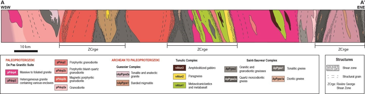
The George Domain is bordered to the east along its entire length by the Rivière George Shear Zone (ZCrge), and to the west — in its southern part — by the Lac Tudor Shear Zone (ZCtud). It is also affected by the Moonbase Shear Zone (ZCmob), which joins the ZCrge halfway through. All of these shear zones have detailed structural records, so only key elements are mentioned in this Geological Bulletin. In addition to these important deformation zones, the George Domain also has a central section where rocks are slightly deformed and mostly represented by units of the De Pas Granitic Suite, as shown schematically on the E-W structural section. The emplacement of this magmatic arc over a period of >50 Ma is concurrent with the ductile deformation associated with the Rivière George, Moonbase and Lac Tudor shear zones. These intrusive rocks preserve primary structures of magmatic origin in several places, while other facies are foliated to highly mylonitized. The presence of almost undeformed rocks can be explained both by the emplacement of post-tectonic intrusions and by the partitioning of deformation within corridors delineating less deformed lenticular blocks.
Structural analyses following mapping (Simard et al., 2013; Lafrance et al., 2014; 2015; 2016; Vanier et al., 2018) show a dominant family of planar NNW-SSE structures, which orientation bifurcates gradually to the N-S in the southern portion of the George Domain.
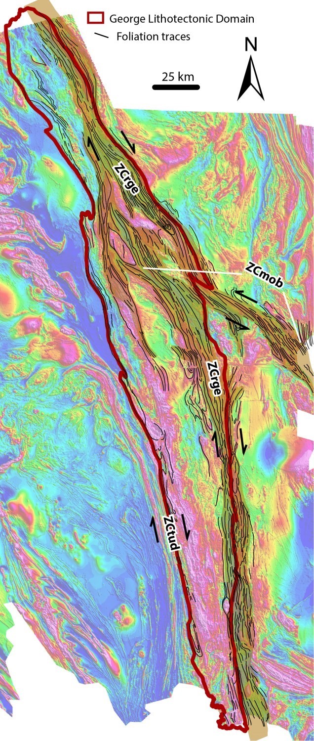
Rocks within the ZCrge are affected by a subvertical planar fabric that is commonly associated with high subhorizontal stretching of quartz and feldspar. Stretching is generally more pronounced than the planar fabric, suggesting constricting deformation. The main deformation occurred under upper amphibolite facies conditions (Vanier et al., 2018). Kinematic indicators are mostly dextral, locally sinistral. Several outcrops show symmetrical fabrics indicating pure shearing. In addition, complex structures with different fabrics, such as folded mylonites, are observed locally. Although the ZCmob has similar structural attributes to the ZCrge, it has a more sinistral kinematics. The attitude of ZCmob planar fabrics is generally NW-SE, at a sharp angle to the ZCrge. Finally, the study area is characterized by subvertical planar fabrics containing a less pronounced subhorizontal mineral stretch lineation (dominance of flat deformation). Structures and thermometry of quartz c-axes suggest a deformation temperature >600°C. Kinematics of this structure is dextral.
The main structures of the George Domain are subvertical shear zones formed at high temperature and exhibiting horizontal displacement. The sharp angle between the Rivière George and Moonbase shear zones, and their respective dextral and sinistral kinematics, are compatible with a conjugate ductile shear system (Vanier et al., 2018). Such a network could be formed by shortening along the SW-NE axis. Some dykes oriented in the same axis may have borrowed extension fractures belonging to this stress field. As for the study area, although it is subparallel to the ZCrge and its kinematics is dextral, its relationship with the latter remains difficult to determine. In fact, on the opposite figure, some geophysical lineaments seem to continue northward towards the ZCrge, while others continue towards the NW. For example, it has already been proposed that the study area should end in horsetail more to the NW, or that it should join oblique dextral thrust faults, such as the Lac Turcotte Fault (Wardle et al., 2002). However, geochronological data provide information on the temporal relationship between the ZCrge and ZCtud. Indeed, the youngest zircon population from a gneiss of the Knox Complex (Baleine Lithotectonic Domain) sampled in the study area indicates a crystallization age around 1828 Ma (Davis and Stucliffe, 2018), which is interpreted as the crystallization age of anatectic liquids. The ZCtud subsolidus deformation is therefore younger than this age. In the case of ZCrge, deformation was active (but significantly less) at ~1825 Ma (Dunphy and Skulski, 1996). Thus, geochronological data limiting the age of deformation reveal that these two corridors were active at approximately the same period.
Regional Tectonics
The tectonic evolution of the George Domain is closely related to shear zones, the main and best known of which is the Rivière George Shear Zone. van der Leeden et al. (1990), based in part on observation of opposing kinematic indicators, propose a first local interpretation consisting of three phases: 1) a ductile dextral strike-slip phase; 2) an oblique sinistral extension phase; and 3) a late contraction phase at the fragile-ductile boundary. Subsequently, the ZCrge was interpreted at the SECP scale as the result of a late dextral strike-slip phase related to the compressive phase of the New Quebec Orogen (Clark and Wares, 2004; Lafrance et al., 2015). Recent work, however, has led to a review of these interpretations in the context of continued progressive deformation. Geochronological markers are the best tools to distinguish progressive deformation from polyphase deformation. Since such data are partial in the SECP, our approach is therefore to check whether one deformation phase can explain the structural characteristics observed.
First, the overall geometry of the SECP exposes a complex network of penecontemporaneous shear zones. Such a complex anastomosed network (>100 km in size) can be formed by progressive deformation that is conducive to the heterogeneous accumulation of deformation combining the different structural facies (Fossen and Cavalcante, 2017; Fossen et al., 2018). Development of the different facies is a function of partitioning of the deformation that concentrated the deformation along shears and thereby generated variations in the intensity of deformation characteristic of this domain. The same phenomenon can lead to the formation of polyphase structures (Fossen et al., 2018). In addition, most shear zones are the product of a combination of simple and pure shearing (Fossen and Cavalcante, 2017). Such conditions apply to the ZCrge, resulting in the formation of antithetic kinematic indicators that thus provide an alternative explanation to a succession of opposing directions. Because of the presence of L>S tectonics, deformation within the ZCrge is not a pure planar deformation, but rather a three-dimensional deformation (Fossen and Cavalcante, 2017). Thus, the structural style of the ZCrge corresponds to a three-dimensional dextral transpressure structure. Similar reasoning can be applied to the lithotectonic domain scale as a whole, since a single deformation phase resulting in a dominant SW-NE shortening may have induced penetrative deformation under medium-crust metamorphic conditions. This structural style is expected in the case of a medium orogenic crust that is detached from the lithospheric mantle and trapped between two more competent bodies, represented here by the Superior and North Atlantic cratons (Cruden et al., 2006; Chardon et al., 2009; Riller et al., 2009). The structural style of the George Domain is thus compatible with the intermediate metamorphic character between a LHO (Large Hot Orogen) and a HO (Hot Orogen), as proposed by Charette (2016). Subvertical shearing with a strong subhorizontal constriction component (ZCrge and ZCmob) could be part of a flow parallel to the orogenic axis (Chardon et al., 2009). In the case of the ZCtud, the present work does not specify its tectonic involvement; however, no recent observations call into question the original interpretation of a dextral transpressure structure as proposed by van der Leeden et al. (1990).
The model proposed in this bulletin places the George Domain in the centre of a hot orogen. Shear zones that dissect it are symptomatic of an orogenic crust of medium depth which has undergone penetrative deformation by SW-NE shortening. These shear zones are characterized by a transpressive nature and a preponderance of L>S tectonics. Both indicate a constricting regime. This is the product of deformation with a first component of pure shearing and a second of simple shearing occurring in a context of flow parallel to the orogenic axis. The general characteristics of these shear zones indicate that they potentially represent the lateral extrusion mechanism during the Trans-Hudsonian Orogen and have either a marginal or no role in the exhumation of metamorphic rocks of the George Domain.
Economic Geology
The George Lithotectonic Domain is prospective for several types of mineralization:
- potential for volcanogenic massive sulphide (VMS) mineralization;
- potential for orogenic gold mineralization;
- potential for IOCG or Cu-Mo-W porphyry mineralization;
- rare metal mineralization associated with granitic pegmatites;
- rare earth mineralization associated with lamprophyres;
- Ni-Cu mineralization associated with mafic and ultramafic intrusions;
- Fe-Ti-V and apatite mineralization associated with mafic intrusions.
The table below presents analytical results for the twenty-five (25) known mineralized zones in the George Lithotectonic Domain.
| Name | Contents |
|---|---|
| Mineralization associated with granitic pegmatites | |
| South Rae-1003 | 748 ppm Th (G); 2480 ppm Zr (G) |
| South Rae-1022 | 1120 ppm Mo (G); 629 ppm Pb (G); 1930 ppm Th (G); 1640 ppm U (G); 4510 ppm Zr (G) |
| South Rae-1022 : 2021 | 2040 ppm Mo (G); 728 ppm Th (G); 425 ppm U (G); 1870 ppm Zr (G) |
| South Rae-2004 | 9022.3 ppm REE (G); 931 ppm Th (G); 520 ppm U (G) |
| South Rae-2018 | 1580 ppm Mo (G); 1480 ppm Pb (G); 570 ppm Th (G); 5470 ppm U (G); 279 ppm Y (G) |
| Other similar mineralized zones | |
| Indeterminate type mineralization | |
| Lac Tudor-Est | 7038,4 ppm U (G) |
| MaryO | 13 ppm Ag (G); 5550 ppm Cu (G) |
| Qamanialuup | 7.8 ppm Ag (G) |
| Ralph | 5 ppm Ag (G); 390 ppm Cu (G) |
(G): selected sample
The table of lithogeochemical analyses of metals of economic interest provides the location, description and analytical results for eighty-four (84) samples selected to assess the economic potential of the region.
Potential for Volcanogenic Massive Sulphide (VMS) Mineralization
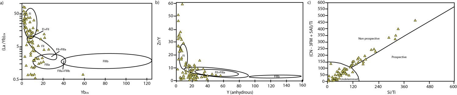
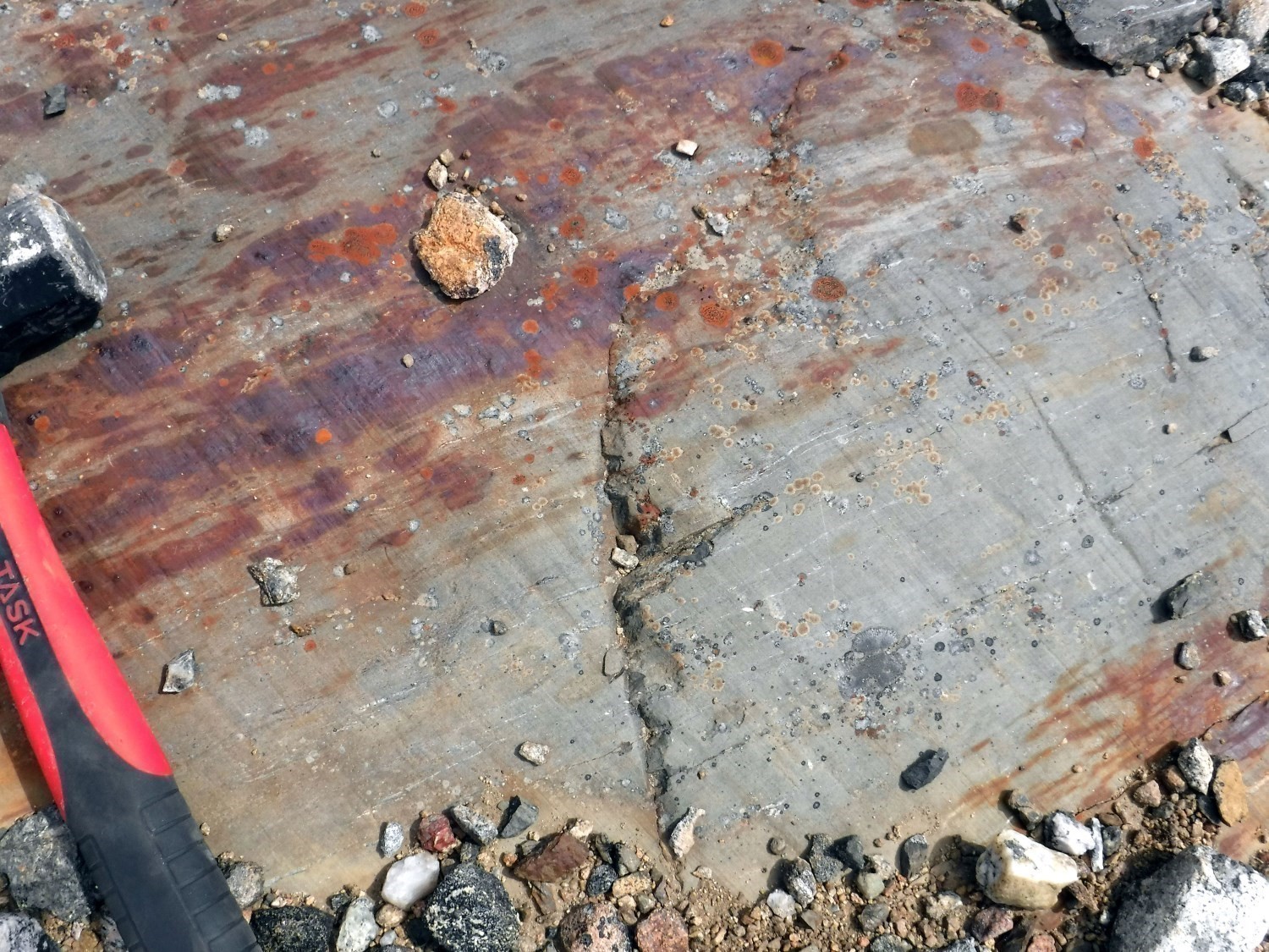
The Tunulic Complex is a volcano-sedimentary rock belt measuring 260 km in lenght by 3 to 14 km in width. Several Archean belts of the same type are recognized worldwide for their potential for orogenic gold or volcanogenic massive sulphide (VMS) mineralization. Despite the presence of bimodal volcanics of tholeiitic to calc-alkaline affinity and the context in which this belt was emplaced, the geochemistry of felsic volcanics suggests that this is not a prospective environment, both using methods based on trace elements (Lesher et al., 1986) and on major elements (Pearson, 2007). Only a few samples fall in the field of FIIIa-type rhyolites, indicating potential for VMS (Lesher et al., 1986). However, it is worth recalling that some deposits considered to be non-prospective using this type of discriminant have already been exploited (e.g., the Selbaie Mine). In addition, a large proportion of felsic samples analyzed in the Tunulic Complex are volcaniclastics and not rhyolite flows, significantly influencing the rare earth fractionation process. In the diagram of Pearson (2007), which uses major elements (not influenced by rare earth fractionation), it is noted that the majority of samples are in the non-prospective or undetermined fields. A few samples located in the Tunulic prospective zone include anomalous values in copper (<2022 ppm Cu), silver (<7.8 g/t Ag), zinc (<790 ppm Zn), molybdenum (<530 ppm Mo) and gold (<98 ppb Au).
Potential for Orogenic Gold Mineralization
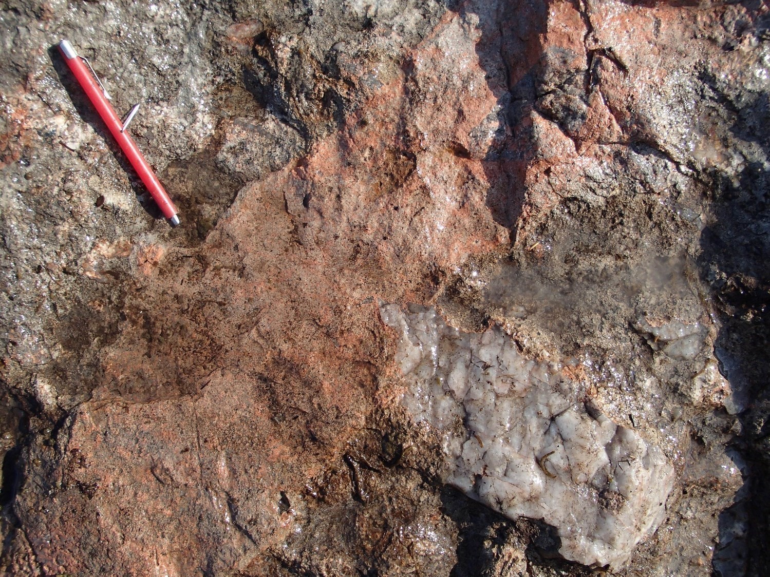
While the potential for the discovery of VMS mineralization remains highly uncertain in the Tunulic Complex, given the rate of deformation of units and the degree of metamorphism (upper amphibolite facies), there are several indications that this complex represents a prospective environment for orogenic gold mineralization. First, the volcano-sedimentary belt is located within the Rivière George Shear Zone (ZCrge), a zone of major subvertical deformation. In addition, the presence of the De Pas Supersuite synchronously intruded in the ZCrge could have served as a huge corridor for the circulation of mineralized fluids. Also, the presence of quartz veins and rusty zones containing disseminated sulphide is typical of orogenic gold mineralization. However, this hypothesis should be verified during more detailed mapping or exploration. Finally, another consideration is that although the majority of known orogenic gold deposits are found in greenschist facies units, they are present at all metamorphic grades (Jébrak and Marcoux, 2008).
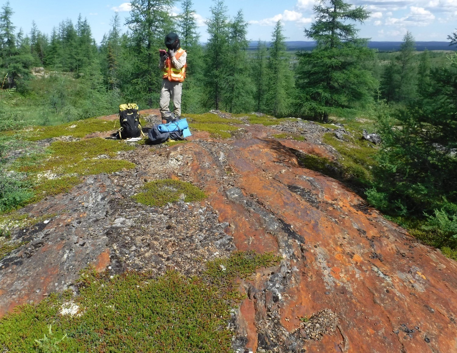

Although a limited number of mineralized zones have been identified to date within volcano-sedimentary units of the Tunulic Complex, they contain many decimetric to metric rusty zones with lateral extension up to several metres. Several of these zones are associated with silica alteration zones accompanied by quartz veins. Mineralization is disseminated or in veinlets and consists mainly of pyrrhotite and trace chalcopyrite.
Potential for IOCG or Cu-Mo-W Porphyry Mineralization
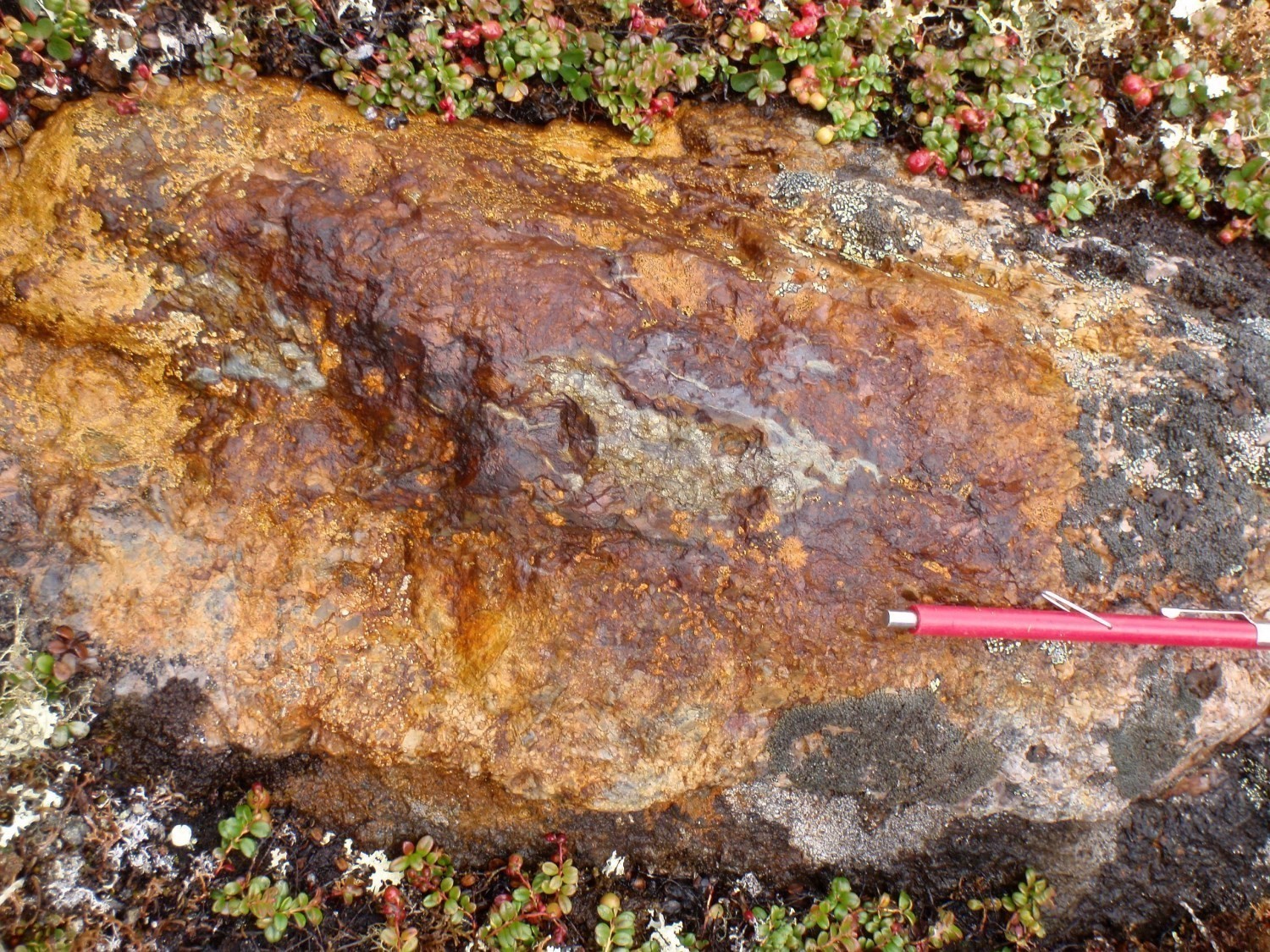
IOCG-type deposits are generally associated with major structures and large magmatic events that allow circulation of fluids over a long period of time (Corriveau, 2007). Like the Tunulic Complex, the De Pas Supersuite is cut along its entire length by the ZCrge and by many families of late fractures. It also represents a polyphase syntectonic intrusion that extends for >440 km in length and 25 to 55 km in width. The emplacement of De Pas intrusive rocks took about 55 Ma. IOCG mineralization is known in different environments such as magmatic arcs, back arc basins and intracratonic rifts (Corriveau, 2007); margins of Archean cratons, where arcs have developed, represent particularly fertile settings. Gandhi (2003) defines six types of IOCG, four of which are genetically associated with calc-alkaline magmatism (like most rocks of the De Pas Supersuite) and two with alkaline magmatism linked to carbonatites. The presence of evolved Type-I or Type A granites and intermediate to mafic facies also represent distinguishing criteria for IOCG (Corriveau, 2007). The De Pas Supersuite includes granite, granodiorite and syenite units, as well as monzonite and monzodiorite.

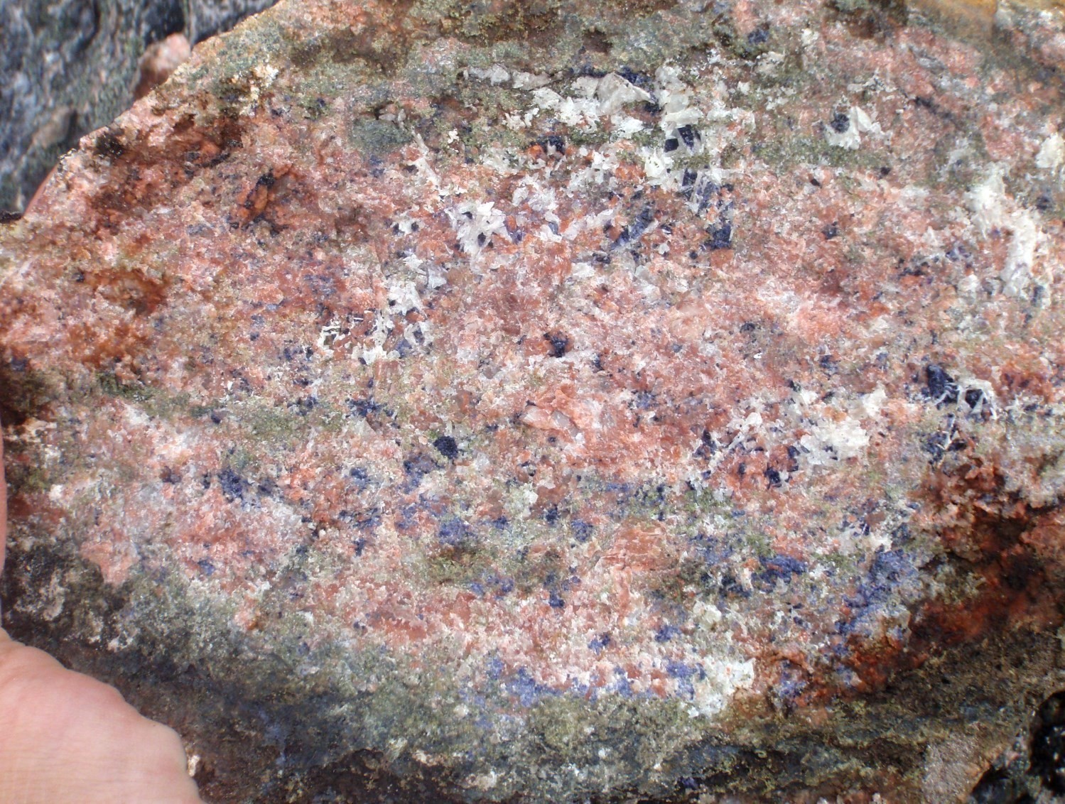
Other evidence indicates that the De Pas Supersuite is a prospective environment for IOCG-type mineralization (Lamirande prospective zone), including the presence of alteration and breccias in the west-central portion of the George Domain. The main alterations involved enrichment in silica, potassium, calcium and iron oxides. Breccias of uncertain origin (possibly hydrothermal) containing small angular fragments, as well as magmatic assimilation zones, were observed in a few places. The main magmatic assimilation zone is interpreted by Lamirande (2015) as resulting from the digestion of a pegmatite and porphyraceous granodiorite by mafic magma related to granodiorite, which would be associated with a late magmatic fluid. The outcrop consists of an amphibolitized gabbro containing metric zones rich in quartz and feldspar xenoliths. Assimilation involved a process of potassic alteration and rock hematitization, as well as crystallization of epidote, chlorite, quartz and calcite around xenoliths.


Further north, the Sam prospective zone, which includes several outcrops described as brecciated anorthosites, could instead represent a proximal sodic alteration zone of an IOCG system (Corriveau et al., 2010). These albite-rich rocks are cut by quartz veins, commonly forming a stockwerk giving the rock a brecciated texture. Host rocks also shows strong pervasive alteration with the development of hematite, chlorite and epidote. Outcrop 2013-SS-7211 is of particular interest since it consists of a tectonic or hydrothermal breccia containing highly altered (sericite-hematite) albite fragments in a matrix of epidote, chlorite, actinolite, magnetite and sphene. Approximately 25 km SW of this prospective zone, a pyrite, chalcopyrite, azurite and pyrrhotite fracture-filling mineralization in an albitized De Pas quartz diorite (pPdep1a?) yielded an anomalous copper content (1042 ppm Cu).
At the eastern edge of the George Domain, fractures filled with fluorite, epidote and calcite were also observed in granite of the De Pas Supersuite (pPdep5). Finally, much of the George Lithotectonic Domain is characterized by a strong radiometric signature and the presence of lake-bottom anomalies and spatial regression targets for uranium and lanthanum (Lamothe, 2009; D’Amours and Intissar, 2013a, b; Intissar et al., 2014; Intissar, 2018). The calc-alkaline to alkaline-calcic affinity of the De Pas Supersuite and the abundance of type I hornblende-sphene granitoids also suggest potential for Cu-Mo-W porphyry mineralization, and for Cu-bearing, Zn-bearing skarns, particularly those containing tungsten associated with metamorphic aureoles at lower structural levels (Jébrak and Marcoux, 2008). Locally, anomalous copper contents associated with sulphides, disseminated and in veinlets, were obtained within De Pas intrusions.
Rare Metal Mineralization Associated with Granitic Pegmatites
The eastern edge of the George Lithotectonic Domain is characterized by its large number of Rössing-type mineralized zones, which consist of uraninite mineralization in peraluminous and potassic granites. A total of twenty-two (22) mineralized zones were discovered by Majescor Resources from ground prospecting around uranium-bearing anomalies of lake-bottom sediments (Lalancette and Girard, 2008). They are grouped under the name “South Rae” and spread over two main mineralized lineaments along the ZCrge. Similar lake-bottom sediment anomalies, for the time being without listed mineralized zones, are located in the SE extension of the same lineaments. They correspond to two corridors of white granite dykes intruding conformably to foliation in a wide variety of units, such as gneiss of the Saint-Sauveur Complex, granitoids of the De Pas Supersuite and paragneiss of the Tunulic Complex. Mineralized dykes have a variable composition with quartz contents ranging from 10% to 70% and a biotite content up to 35%. Mineralization is mainly associated with pegmatitic phases and consists mainly of uraninite and uranophane (trace-5%) attached to biotite-rich clusters. Such uranium concentrations would be associated with migmatization fronts marked by deep pegmatites (Jébrak and Marcoux, 2008). Several samples collected by Majescor also contain disseminated molybdenite and pyrrhotite. In fact, many anomalous or showing contents were obtained in rare earths (<9022 ppm REE), zirconium (1990 ppm Zr), molybdenum (2040 ppm Mo), yttrium (<270 ppm Y) and lead (1560 ppm Pb).
Rare Earth Mineralization Associated with Lamprophyres
Lamprophyre intrusions of the Fayot Suite show rare earth enrichment (Fayot prospective zone). These intrusions form small massive plutons in the George Lithotectonic Domain. The best content was obtained in a magnetic melanocratic lamprophyre containing 35% ferromagnesian minerals (clinopyroxene, biotite and amphiboles). The sample yielded contents of 1256 ppm total REE (mostly light), 2209 ppm Sr, 1.3% P2O5 and 668 ppm Zr (outcrop 14DB1146). Rare earth mineralization is associated with accessory minerals such as apatite, sphene, allanite, zircon and fluorite (Chartier, 2015).

In the same area, a decimetric pegmatite dyke cutting melanocratic lamprophyre of the Fayot Suite contains a massive sulphide lens (pyrite, pyrrhotite and chalcopyrite) that yielded showing contents of copper (5550 ppm Cu) and silver (13 g/t Ag; MaryO mineralized zone).
Ni-Cu Mineralization Associated with Mafic and Ultramafic Intrusions

The George Domain includes mafic and ultramafic intrusions that may contain Ni-Cu magmatic mineralization. One of the main mineralized zones of this type is hosted in a troctolite dyke assigned to the Falcoz Swarm. This zone called “Bone Une” by WMC International (Deveau et al., 2001), ~300 m wide, outcrops intermittently and was visited during our work (outcrop 11IL3103). Primary ferromagnesian minerals are replaced by chlorite, fibrous actinolite, serpentine, carbonates and talc. Mineralization, consisting of disseminated pyrrhotite (5-10%) and chalcopyrite (<1%), is contained in rusty zones and highly sericitized metric to decametric gossan caps. A sample selected by the Ministère confirmed anomalous contents of copper (2022 ppm Cu) and nickel (1933 ppm Ni). Anomalous contents of copper (<840 ppm Cu) and nickel (<1900 ppm ni) were also obtained in similar rusty zones within gabbro sills and ultramafic rocks of the Tunulic Complex.
Fe-Ti-V and Apatite Mineralization Associated with Mafic Intrusions
Some gabbro sills of the Tunulic Complex yielded anomalous contents of vanadium (<1399 ppm V), iron (<20%) and titanium (1.4% Ti). The mineralization’s host rock is mostly composed of fibrous amphibole, vanadiferous magnetite laminae and ilmenite with some chlorite and sulphides.
The Bonaventure Pluton, located in southern SECP, generally shows anomalous contents of <111 ppm Nb, <18.4% Fe2O3t and <2.99% P2O5 (Bonaventure prospective zone). Anomalous samples come from high-magnetic gabbronorite and websterite layers enriched with apatite (crystals 0.15-0.3 mm). Magmatic textures, especially cumulate textures, are relatively well preserved.
| Authors |
Benoit Charette, P.Geo., M.Sc. benoit.charette@mern.gouv.qc.ca Isabelle Lafrance, P.Geo., M.Sc. isabelle.lafrance@mern.gouv.qc.ca Marc-Antoine Vanier, Jr. Eng. marc-antoine.vanier@mern.gouv.qc.ca |
| Geomatics | Julie Sauvageau and Kathleen O’Brien |
| Critical review | Patrice Roy, P.Geo., M.Sc. |
| Linguistic revision | Simon Auclair, P.Geo., M.Sc. |
| English version | Céline Dupuis, P.Geo., Ph.D. |
| Organism | General Direction of Géologie Québec, Ministère de l’Énergie et des Ressources naturelles, Government of Québec |
Acknowledgements:
This Geological Bulletin was made possible through the cooperation of many people who have been actively involved in the various stages of the project. We would like to thank all geologists, students and support staff who participated in the Ministère’s mapping work during the summers of 2011 to 2016. Discussions with geologists Fabien Solgadi and Mona Baker were very beneficial.
References
Publications Available Trough Sigéom Examine
BOURQUE, Y., 1991. GEOLOGIE DE LA REGION DU LAC MINA (TERRITOIRE-DU-NOUVEAU-QUEBEC). MRN; ET 88-08, 49 pages, 4 plans.
CHARETTE, B., LAFRANCE, I., MATHIEU, G., 2016. Géologie de la région du lac Jeannin, Québec, Canada. MERN; BG 2015-01, 1 plan.
CLARK, T., WARES, R., 2004. SYNTHESE LITHOTECTONIQUE ET METALLOGENIQUE DE L’OROGENE DU NOUVEAU-QUEBEC (FOSSE DU LABRADOR). MRNFP; MM 2004-01, 182 pages, 1 plan.
D’AMOURS, I., INTISSAR, R., 2013a. LEVE MAGNETIQUE ET SPECTROMETRIQUE AEROPORTE DANS LE SECTEUR DE LA RIVIERE A LA BALEINE, PROVINCE DE CHURCHILL. MRN; DP 2013-03, 10 pages, 170 plans.
D’AMOURS, I., INTISSAR, R., 2013b. LEVE MAGNETIQUE ET SPECTROMETRIQUE AEROPORTE DANS LE SECTEUR DU LAC ROMANET, PROVINCE DE CHURCHILL. MRN; DP 2013-02, 10 pages, 280 plans.
DANIS, D., 1988. GEOLOGIE DE LA REGION DU LAC RECOUET (TERRITOIRE DU NOUVEAU-QUEBEC). MRN; ET 86-11, 62 pages, 4 plans.
DANIS, D., 1991. GEOLOGIE DE LA REGION DU LAC RAUDE (TERRITOIRE-DU-NOUVEAU-QUEBEC). MRN; ET 88-10, 73 pages, 5 plans.
DAVID, J., MCNICOLL, V., SIMARD, M., BANDYAYERA, D., HAMMOUCHE, H., GOUTIER, J., PILOTE, P., RHEAUME, P., LECLERC, F., DION, C., 2011. Datations U-Pb effectuées dans les provinces du Supérieur et de Churchill en 2009-2010. MRNF; RP 2011-02, 37 pages.
DAVIS, D. W., LAFRANCE, I., GOUTIER, J., BANDYAYERA, D., TALLA TAKAM, F., GIGON, J., 2018. Datations U-Pb dans les provinces de Churchill et du Supérieur effectuées au JSGL en 2013-2014. MERN; RP 2017-01, 63 pages.
DAVIS, D.W., SIMARD, M., HAMMOUCHE, H., BANDYAYERA, D., GOUTIER, J., PILOTE, P., LECLERC, F., DION, C., 2014. Datations U-Pb effectuées dans les provinces du Supérieur et de Churchill en 2011-2012. MERN, GEOCHRONOLOGICAL LABORATORY; RP 2014-05, 62 pages.
DAVIS, D. W., SUTCLIFFE, C. N., 2018. U-Pb Geochronology of Zircon and Monazite by LA-ICPMS in samples from northern Quebec. UNIVERSITY OF TORONTO; MB 2018-18, 54 pages.
DEVEAU, S. W., MCKINNON-MATTHEWS, J., HARRIS, B., STOLLENWERK, M., DOHERTY, M., MCCALL, L., 2001. THE 2000-2001 EXPLORATION PROGRAM ON THE QUEBEC 7 PROPERTY. WMC INTERNATIONAL LIMITED, rapport statutaire soumis au gouvernement du Québec; GM 59375, 1326 pages, 11 plans.
GEO DATA SOLUTIONS GDS INC, COMMISSION GEOLOGIQUE DU CAN, 2009. LEVE AEROMAGNETIQUE HAUTE RESOLUTION A L’EST DE SCHEFFERVILLE. DP 2009-04, 96 pages, 16 plans.
GIRARD, R., 1990. GEOLOGIE DE LA REGION DE LA RIVIERE DEAT (RAPPORT FINAL). MRN; MB 90-15, 154 pages, 2 plans.
HAMMOUCHE, H., LEGOUIX, C., GOUTIER, J., DION, C., PETRELLA, L., 2011. GEOLOGIE DE LA REGION DU LAC BONAVENTURE. MRNF; RG 2011-03, 37 pages, 1 plan.
INTISSAR, R., 2018. LEVE MAGNETIQUE ET SPECTROMETRIQUE HELIPORTE DANS LE SECTEUR DE LA RIVIERE GEORGE, EST DE LA BAIE D’UNGAVA. MERN, NOVATEM INC; DP 2018-01, 7 pages, 10 plans.
INTISSAR, R., BENAHMED, S., D’AMOURS, I., 2014. LEVE MAGNETIQUE ET SPECTROMETRIQUE AEROPORTE DANS LE SECTEUR SUD DE LA RIVIERE GEORGE, PARTIE SUD-EST DE LA PROVINCE DE CHURCHILL. MRN; DP 2014-01, 9 pages, 250 plans.
JÉBRAK, M., MARCOUX, E., 2008. Géologie des ressources minérales. Ministère des Ressources naturelles, Québec; MM 2008-01, 667 pages.
LAFRANCE, I., BANDYAYERA, D., BILODEAU, C., 2015. Géologie de la région du lac Henrietta (SNRC 24H). MERN; RG 2015-01, 62 pages, 1 plan.
LAFRANCE, I., BANDYAYERA, D., CHARETTE, B., BILODEAU, C., DAVID, J., 2016. GEOLOGIE DE LA REGION DU LAC BRISSON (SNRC 24A). MERN; RG 2015-05, 64 pages, 1 plan.
LAFRANCE, I., SIMARD, M., BANDYAYERA, D., 2014. Géologie de la région du lac Saffray (SNRC 24F, 24G). MRN; RG 2014-02, 51 pages, 1 plan.
LAFRANCE, I., CHARETTE, B., VANIER, M.-A., 2018. Sud-est de la Province de Churchill, Nunavik, Québec, Canada: synthèse de la géologie. MERN; BG 2018-12
LALANCETTE, J., GIRARD, R., 2008. TRAVAUX GEOLOGIQUES DE RECONNAISSANCE POUR L’URANIUM, PROJET SOUTH RAE. EXPLORATION AZIMUT INC, rapport statutaire soumis au gouvernement du Québec; GM 63947, 118 pages, 4 plans.
LAMOTHE, D., 2009. CARTES GEOCHIMIQUES MODELBUILDER ET CIBLES ANOMALES DE L’ENVIRONNEMENT SECONDAIRE POUR LE QUEBEC. MRNF; MB 2009-11, 33 plans.
MARTELAIN, J., 1986. RAPPORT D’ACTIVITE 1986 – DIRECTION DE LA RECHERCHE GEOLOGIQUE. M E R; DV 86-14, 93 pages.
OWEN, J. V., 1989. GEOLOGIE DE LA REGION DU LAC LEIF (TERRITOIRE DU NOUVEAU-QUEBEC). MRN; ET 87-18, 56 pages, 3 plans.
SIMARD, M., LAFRANCE, I., HAMMOUCHE, H., LEGOUIX, C., 2013. GEOLOGIE DE LA REGION DE KUUJJUAQ ET DE LA BAIE D’UNGAVA (SNRC 24J, 24K). MRN; RG 2013-04, 62 pages, 1 plan.
VAN DER LEEDEN, J., 1994. GEOLOGIE DE LA REGION DU LAC DE LA HUTTE SAUVAGE (TERRITOIRE DU NOUVEAU-QUEBEC). MRN; MB 94-32, 109 pages, 2 plans.
VAN DER LEEDEN, J., 1995. GEOLOGIE DE LA REGION DU LAC MISTINIBI (TERRITOIRE DU NOUVEAU-QUEBEC). MRN; MB 95-45, 107 pages, 3 plans.
VANIER, M.-A., GODET, A., GUILMETTE, C., HARRIS, L. B., CLEVEN, N. R., CHARETTE, B., LAFRANCE, I., 2018. Extrusion latérale en croûte moyenne dans le sud-est de la Province de Churchill démontrée par les interprétations géophysiques, l’analyse structurale et les pétrofabriques du quartz. UNIVERSITE LAVAL, INRS, MERN; MB 2018-12, 58 pages.
Other Publications
BARDOUX, M., DIGONNET, S., DONOHUE, L., GIRAD, B., ROBILLARD, M., DAVID, J., PARENT, M., GARIÉPY, C., 1998. Paleoproterozoic tectonics affecting Archean lower crust of southern Ungava Bay. In : Eastern Canadian Shield Onshore–Offshore Transect (ECSOOT), Report of the 1998 Transect Meeting (Wardle, R.J., Hall, J., editors). The University of British Columbia, Lithoprobe Secretariat; Report, volume 68, pages 1-17.
CHARDON, D., GAPAIS, D., CAGNARD, F., 2009. Flow of ultra-hot orogens: A view from the Precambrian, clues for the Phanerozoic. Tectonophysics; volume 477, pages 105-118, doi.org/10.1016/j.tecto.2009.03.008.
CHARETTE, B., 2016. Long-lived Anatexis in the Exhumed Middle Crust from the Torngat Orogen and Eastern Core Zone: Constraints from Geochronology, Petrochronology, and Phase Equilibria Modeling. University of Waterloo; M.Sc. thesis, 427 pages. Source
CHARTIER, M.O., 2015. Caractérisation pétrographique et géochimique des roches alcalines de la Suite de Fayot, Province de Churchill. Université du Québec à Chicoutimi; projet de fin d’études, 51 pages.
CORRIGAN, D., WODICKA, N., McFARLANE, C.,LAFRANCE, I., VAN ROOYEN, D., BANDYAYERA, D., BILODEAU, C., 2018. Lithotectonic framework of the Core Zone, Southeastern Churchill Province. Geoscience; volume 45, pages 1-24, doi.org/10.12789/geocanj.2018.45.128.
CORRIVEAU, L., 2007. Iron oxyde copper-gold (±Ag ± Nb ±P ±REE ±U) deposits: a Canadian perspective. In: Mineral deposits of Canada: a synthesis of major deposit-types, district metallogeny, the evolution of geological provinces, and exploration methods (Goodfellow, W.D., editor). Geological Association of Canada, Mineral Deposits Division; Special Publication no. 5, pages 307-328.
CORRIVEAU, L., WILLIAMS, P.J., MUMIN, A.H., 2010. Alteration vectors to IOCG mineralization – from uncharted terranes to deposits. In: Exploring for Iron Oxide Copper-Gold Deposits: Canada and Global Analogues (Corriveau, L., Mumin, H., editors). Geological Association of Canada; Short Course Note 20, 185 pages.
CRUDEN, A.R., NASSERI, M.B., PYSKLYWEC, R.N., 2006. Surface topography and internal strain variation in wide hot orogens from three-dimensional analogue and two-dimensional numerical vise models In: Analogue and Numerical Modelling of Crustal-Scale Processes (Buiter, S.J.H., Schreurs, G., editors). Geological Society of London; Special Publication 253, pages 79-104. doi.org/10.1144/GSL.SP.2006.253.01.04
DUNPHY, J.M., SKULSKI, T., 1996. Petrological zonation across the De Pas Batholith: a tilted section through a continental arc? In : Eastern Canadian Shield Onshore–Offshore (ECSOOT) Transect Meeting 1996 (Wardle R.J., Hall, J., editors). The University of British Columbia, Lithoprobe Secretariat; Report 57, pages 44-58.
FOSSEN, H., CAVALCANTE, G.C.G., 2017. Shear zones – A review. Earth-Science Reviews; volume 171, pages 434-455. doi.org/10.1016/J.EARSCIREV.2017.05.002.
FOSSEN, H., CAVALCANTE, G.C.G., PINHEIRO, R.V.L., ARCHANJO, C.J. 2018. Deformation – Progressive or multiphase? Journal of Structural Geology; volume 125, pages 82-99. doi.org/10.1016/J.JSG.2018.05.006.
GANDHI, S., 2003. An overview of the Fe oxide-Cu-Au deposits and related deposit types : CIM Montreal 2003 Mining Industry Conference ans Exhibition, Canadian Institute of Mining, Technical Paper, CD-ROM.
GODET, A., GUILMETTE, C., LABROUSSE, L.,SMIT, M.A., DAVIS, D.W., RAIMONDO, T., VANIER, M.A., CHARETTE, B., LAFRANCE, I., 2020. Contrasting P-T-t paths reveal a metamorphic discontinuity in the New Quebec Orogen: Insights into Paleoproterozoic orogenic processes. Precambrian Research; volume 342, article 105675. doi.org/10.1016/j.precamres.2020.105675 .
ISNARD, H., PARENT, M., BARDOUX, M., DAVID, J., GARIÉPY, C., STEVENSON, R.K., 1998. U-Pb, Sm–Nd and Pb–Pb isotope geochemistry of the high-grade gneiss assemblages along the southern shore of Ungava Bay. In : Eastern Canadian Shield Onshore–Offshore (ECSOOT), Transect Meeting, 1998 (Wardle R.J., Hall, J., editors). The University of British Columbia, Lithoprobe Secretariat; Report 68, pages 67-77.
JAMES, D.T., MAHONEY, K.L., 1994. Structural, Metamorphic and intrusive relations in the Hinterland of the Eastern Churchill Province, Western Labrador. Current Research, Newfoundland Department of Mines ans Energy. Geological Survey Branch; Report 94-1, pages 371-385.
JAMES, D.T., DUNNING, G.R., 2000. U-Pb geochronological constraints for Paleoproterozoic evolution of the Core Zone, southeastern Churchill Province, northeastern Laurentia. Precambrian Research; volume 103, pages 31-54, doi.org/10.1016/S0301-9268(00)00074-7.
JAMES, D.T., CONNELLY, J.N., WASTENEYS, H.A., KILFOIL, G.J., 1996. Paleoproterozoic lithotectonic divisions of the southeastern Churchill Province, western Labrador. Canadian Journal of Earth Sciences; volume 33, pages 216-230. doi.org/10.1139/e96-019.
KERR, A., JAMES, D.T., FRYER, B.J., 1994. Nd isotopic geochemical studies in the Labrador shield: a progress report ans preliminary data from the Churchill (Rae) Province. Geological Survey of Newfoundland and Labrador; Department of Natural Resources, pages 51-61.
KROGH, T.E., 1986. Report to Newfoundland Department of Mines and Energy on isotopic dating results from the 1985-1986 geological research agreement. Newfoundland Department of Mines and Energy, Mineral Development Division; Open File Report LAB 707.
LAMIRANDE, P.H., 2015. Caractérisation d’une zone d’assimilation magmatique dans le batholite de De Pas, Province de Churchill, Québec. Université Laval; projet de fin d’études, 66 pages.
LESHER, C. M., GOODWIN, A.M., CAMPBELL, I.H., GORTON, M.P., 1986. Trace-element geochemistry of ore-associated and barren, felsic metavolcanic rocks in the Superior Province, Canada. Canadian Journal of Earth Science; volume 23, pages 222-237, doi.org/10.1139/e86-025.
LOW, A.P., 1896. Report on exploration in the Labrador peninsula along the East Main, Koksoak, Hamilton, Manicouagan and portions of other rivers in 1892-93-94-95. Geological Survey of Canada; Annual Report 1895, volume VIII, doi.org/10.4095/293888.
MACHADO, N., GOULET, N., GARIÉPY, C., 1989. U-Pb geochronology of reactivated Archean basement and of Hudsonian metamorphism in the northern Labrador Trough. Canadian Journal of Earth Sciences; volume 26, pages 1-15, doi.org/10.1139/e89-001.
MARTELAIN, J., CHENEVOY, M., BÉLANGER, M., 1998. Le batholite de De Pas, Nouveau-Québec/ infrastructure composite d’arc magmatique protérozoïque. Revue canadienne des Sciences de la Terre; volume 35, pages 1-15, doi.org/10.1139/e97-084.
PEARSON, V., 2007. Le PER-GH: un nouvel indice de classification des volcanites felsiques pour la reconnaissance des environnements fertiles. CONSOREM, projet 2004-02, 27 pages. Source
RILLER, U. 2009. Felsic plutons In: A field guide to the Geology of Sudbury, Ontario (Rousell, D.H., Brown, G.H., editors). Ontario Geological Survey; Open File Report 6243, pages 11-13.Source
ROCK, N.M.S., 1991. Lamprophyres. Springer, New York, 285 pages. doi.org/10.1007/978-1-4757-0929-2
TAYLOR, F.C., 1979. Reconnaissance geology of a part of the Precambrian Shield, northeastern Quebec, northern Labrador and northwest Territories. Geological Survey of Canada; Memoir 393, 99 pages and 19 maps, doi.org/10.4095/124930.
VAN DER LEEDEN, J., BELANGER, M., DANIS, D., GIRARD, R., MARTELAIN, J., 1990. Lithotectonic domains in the high-grade terrain east of the Labrador Trough (Quebec) In: The Early Proterozoic Trans-Hudson Orogen (Lewry, J.F., Stauffer, M.R., editors). Geological Association of Canada; Special Paper, volume 37, pages 371-386.
WARDLE, R.J., JAMES, D.T., SCOTT, D.J., HALL, J., 2002. The southeastern Churchill Province: synthesis of a Paleoproterozoic transpressional orogen. Canadian Journal of Earth Science; volume 39, pages 639-663, doi.org/10.1139/e02-004.
WARDLE, R.J., RYAN, B., ERMANOVICS, I., 1990a. The eastern Churchill Province, Torngat and New Québec orogens: An overview. Geoscience Canada; volume 17, numéro 4, pages 217-222. Source
WARDLE, R.J., RYAN, B., NUNN, G.A.G., MENGEL, F.C., 1990b. Labrador segment of the Trans-Hudson Orogen: crustal development through oblique convergence and collision In: The Early Proterozoic Trans-Hudson Orogen (Lewry, J.F., Stauffer, M.R., editors). Geological Association of Canada; Special Paper, volume 37, pages 353-369.