


Baleine Lithotectonic Domain, Southeastern Churchill Province, Nunavik, Quebec, Canada: Geological Synthesis
Isabelle Lafrance, Marc-Antoine Vanier, Benoit Charette
BG 2020-07
Published 23 October 2020 (original French version)


In Essence
The synthesis of the Southeastern Churchill Province (SECP; Lafrance et al., 2018) has allowed for the redefinition of the Baleine Lithotectonic Domain boundaries. A geological map and stratigraphic diagram of the domain are presented in this bulletin. The Baleine Domain is characterized by extensive areas of orthogneiss, numerous felsic to mafic intrusive rocks and, in its central part, by the presence of a large sequence of highly migmatized sedimentary rocks. Geochronology work has allowed for the revision of the boundaries of the Rachel-Laporte Lithotectonic Domain, which coincide with the presence of Archean gneiss or paragneiss.
This geological context is prospective for magmatic Ni-Cu-PGE, V-Fe-Ti, as well as rare metal mineralization associated with pegmatitic granite and hyperalkaline rocks. In addition, in the southern part of the domain, there is potential for porphyry-type Cu-Au-Mo mineralization related to the Champdoré Suite potassic intrusion. This prospective zone is associated with epithermal Au-Cu-Ag vein mineralization hosted in a metavolcanic rock sequence of the Curot Suite.
Methodology
The Baleine Lithotectonic Domain was mapped using the established method for surveys in isolated areas without road access. Geological mapping works at scale 1:250 000 covering most of the domain was conducted by teams of six to eight geologists and seven to nine students during the summers 2011 to 2015. Field checks were conducted in the southern portion of the domain in the summer of 2016 by a team of four geologists and three students. Some areas in sheet 24K were also remapped to a finer scale in the summer of 2015, mainly as part of a master’s project (Lamirande and Bilodeau, 2018). The Ministère’s previous mapping work in the southern portion of the domain has also been considered during data processing, including work conducted in the summers of 2009 (Hammouche et al., 2011).
At its NW end, the Baleine Domain includes a detached block forming the Diana Structural Complex. This complex comprises all the units in this area belonging to the Churchill Province. It comprises lithologies of different compositions and ages of emplacement (Archean to Proterozoic), but that were metamorphosed in the Paleoproterozoic. Although the statistics concerning this area have been included in the synthesis (number of samples, mineralized zones, etc.), no correlation has been made between lithologies of the Diana Complex and other units of the Baleine Domain in the absence of field checks. This area is therefore not presented on geological maps nor described in the various sections of this bulletin, since its geology has remained unchanged since the work of Madore and Larbi (2000).
The mapping and synthesis of the Baleine Domain have produced and updated information presented in the opposite table.
| Element | Number |
|---|---|
| Described outcrop (“geofiche”) | 4949 outcrops |
| Total lithogeochemical analyses | 660 analyses |
| Lithogeochemical analysis of metals of economic interest | 152 analyses |
| Geochronological analysis | 39 |
| Covered thin section | 509 |
| Polished thin section | 38 |
| Sodium cobaltinitrite stain | 169 |
| Stratigraphic unit | 29 |
| Mineralization record | 44 |
Previous Work
The table below lists the work that has been done in the study area since 1896. It also includes the references cited in the report.
| Author(s) | Type of Work | Contribution |
|---|---|---|
| Low, 1896; Bell and Low, 1900 | Geological survey | First geological inventory work in the Southeastern Churchill Province (SECP) |
| Regional geological mapping at scale 1:250 000 | First systematic geological mapping work at the scale of the SECP | |
| Geological mapping at scale 1:50 000 | Geology of NTS sheets 23I, 23P, 24A, 24K, 24M and 24N | |
| Geological mapping at scale 1:250 000 | Geology of NTS sheets 23P, 24A, 24J, 24G, 24H, 25C, 25D, 25E and 25F | |
|
Bardoux et al., 1998; Poirier et al., 1990 Van der Leeden et al., 1990 Wardle et al., 1990a, 1990b et 2002 |
Compilation, geological synthesis, lithotectonic divisions and geodynamic implications |
Context and geotectonic evolution of the SECP |
|
Moorhead, 1989; Poirier, 1989 |
Structural, stratigraphic and metamorphic studies | Analysis of shear zones; metamorphic modelling |
|
Machado et al., 1989; Isnard et al., 1998 David et al., 2011; David, 2020 Davis et al., 2014, 2015; Augland et al., 2016 |
Geochronology, synthesis, lithotectonic divisions and geodynamic implications | U-Pb dating in the Baleine Domain in Quebec: Ungava, Qurlutuq, Knox, Griffis and Kaslac complexes, Aveneau, Dancelou, Saffray, Winnie, False, Soisson, Grand Rosoy, Lhande and Champdoré suites. |
| Geochronology, synthesis and lithotectonic divisions | U-Pb dating in the extension of the Baleine Domain in Labrador: Knox Complex | |
| Geophysical surveys | High-resolution aerial magnetic and spectrometric surveys in the Baleine Domain |
Lithostratigraphy
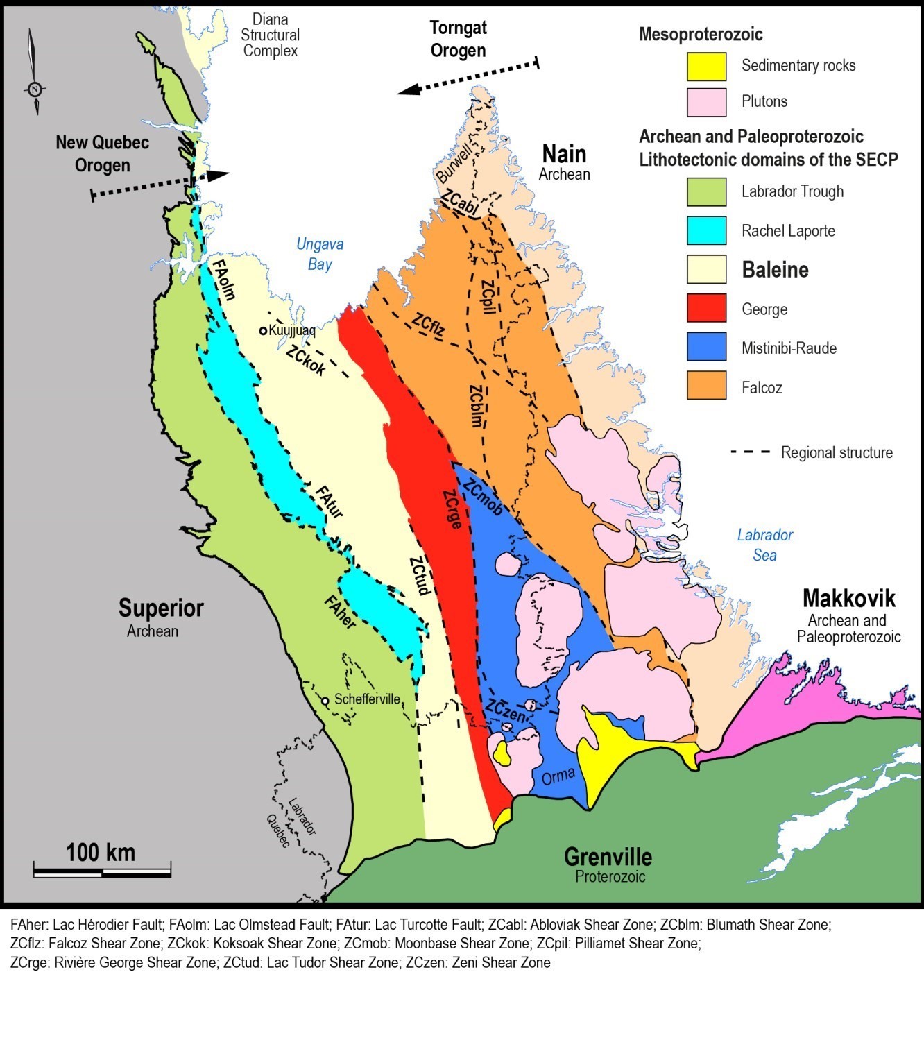
The Baleine Lithotectonic Domain is located in the central-western part of the Southeastern Churchill Province (SECP). The central part of this domain is characterized by the presence of a highly migmatized metasedimentary rock cover (False and Winnie suites) and Archean potassic intrusions showing a general E-W orientation (Saffray suite). The northern and southern parts of the Baleine Domain, however, present different lithological characteristics and structural styles (see Structural Geology section). In the northern part, Simard et al. (2013) and Lafrance et al. (2014) defined distinct domains based on the lithological assemblages present: 1) the Gabriel Domain, dominated by volcano-sedimentary rocks of the Akiasirviup and Curot suites; 2) the Baie aux Feuilles Domain, which contains intrusive units of the Kaslac Complex, Tasialuk Suite and Kuujjuaq Pluton; and 3) the Buteux Domain, consisting mainly of the metasedimentary Winnie and False suites. These divisions, interpreted by these authors as slices of Paleoproterozoic units bounded by thrust faults, could be considered subdomains within the Baleine Domain. However, more detailed mapping work is needed to better define them. These divisions are not included in this synthesis.
In the same area, the boundary with the Rachel-Laporte Lithotectonic Domain (west of the Baleine Domain) has been shifted westward relative to the work of Simard et al. (2013) due to the presence of Archean gneiss east of the Lac Olmstead Fault (FAolm), which now forms the boundary between the two domains in this area. Further south, this boundary is represented by the Lac Turcotte Fault (FAtur), which joins the FAolm in the Diana Lake area (sheet 24K06). The gneiss in question were previously assigned to the Ballantyne Suite (now abandoned) within the Rachel-Laporte Domain (Simard et al., 2013). However, the Archean age of these rocks and field verification in the summer of 2015 (Bilodeau, personal communication) do not allow distinguishing these gneiss from those of the Ungava Complex, which is why they are now part of the Baleine Domain.
Like the northern part, the southern part of the Baleine Domain includes distinctive units, the main ones being the Champdoré and Grand Rosoy suites. The latter, previously assigned to the Laporte Group of the Rachel-Laporte Domain (Girard, 1995; Hammouche et al., 2011), contains Archean detrital zircons (2825-2618 Ma; Davis and Sutcliffe, 2018a), which justifies its attachment to the Baleine Domain. The absence of Paleoproterozoic detrital zircons in metasedimentary rocks of the Grand Rosoy Suite distinguishes them from those of the Rachel-Laporte Domain, which contain both Archean and Paleoproterozoic detrital zircon populations (Henrique-Pinto et al., 2017). For this reason, the boundary between the Rachel-Laporte and Baleine domains has also been shifted westward in this area.
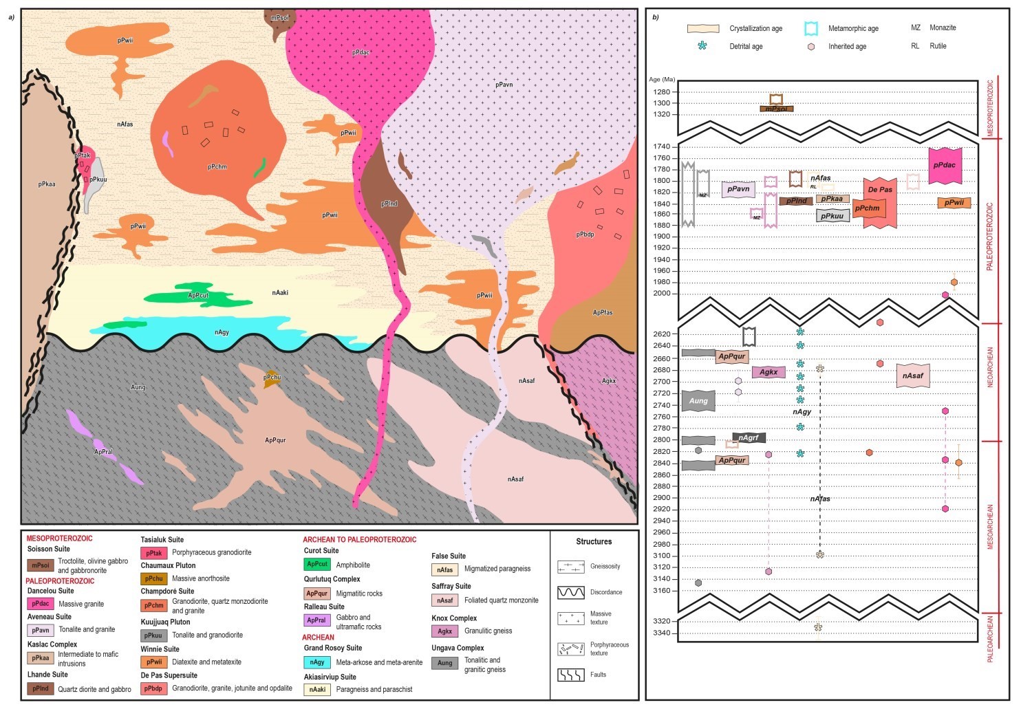
This section provides a summary description of stratigraphic units of the Baleine Domain presented according to the type of lithology, their spatial distribution and their relative chronology. A more detailed description is available in the Stratigraphic Lexicon via the hyperlinks below. The simplified stratigraphic diagram opposite illustrates the relationships between the different units in order to help the reader better understand their spatial and chronological arrangement. It is accompanied by a time scale listing the age of geological units. The dimension of the units in the diagram approximately respects the mapped areas. References associated with the dating can be found in the legend of the map of the Baleine Lithotectonic Domain and in records of the Stratigraphic Lexicon.
Archean Gneissic Rocks
The Archean gneissic bedrock represents more than a quarter of the Baleine Domain. Although it covers larger areas in the northern part, the Ungava Complex (Aung), the main gneiss unit, is distributed throughout the domain. Variations in composition and the significant span of Archean ages (2950-2656 Ma) indicate that this complex probably contains several distinct intrusive units. Regionally, ages obtained for tonalitic gneiss may correspond in part to tonalitic magmatism episodes recognized in the Douglas-Harbour Domain of the Superior Province (2880-2775 Ma; Simard et al., 2008). The most important tonalite unit of the Douglas-Harbour Domain is the Faribault-Thury Suite (2785-2775 Ma), consisting of foliated to gneissic biotite ± hornblende tonalite of migmatitic appearance. In the Baleine Domain, Paleoproterozoic metamorphic ages coming from the Ungava Complex (1864-1786 Ma) are contemporaneous with migmatization of paragneiss of the False Suite, partial melting of migmatites of the Winnie Suite and emplacement of the majority of the Paleoproterozoic intrusive units.
Other units of Archean gneiss outcrop in the southern part of the Baleine Domain. The Knox Complex (Agkx), mostly orthopyroxene-bearing, occurs as interdigitations or enclaves in units of the De Pas Charnockitic Suite. The Griffis Complex (nAgrf), consisting of orthogneiss, migmatites, intrusive rocks and paragneiss, was previously considered an Archean block within the Rachel-Laporte Domain (Hammouche et al., 2011) before the boundary between the domains was shifted.
Archean gneisses are migmatized to varying degrees. In the Ungava Complex, the rocks most affected by partial melting have been assigned to the Qurlutuq Complex (ApPqur), whose Archean age supports the hypothesis that migmatites derive from partial melting of gneiss. Geochronological results from Augland et al. (2016) indicate that rocks of this unit underwent ancient migmatization in the Archean. However, a Paleoproterozoic partial melting episode between 1.9 Ga and 1.8 Ga is not excluded, although it is difficult to verify as it appears as thin overgrowths on zircons.
Gneiss and migmatites contain enclaves, layers and boudins of mafic and ultramafic intrusive rocks assigned to the Ralleau Suite (ApPral). The age of this unit is not known, but field observations suggest that it may in part represent ancient mafic dykes that have been boudinaged or transposed into gneissosity.
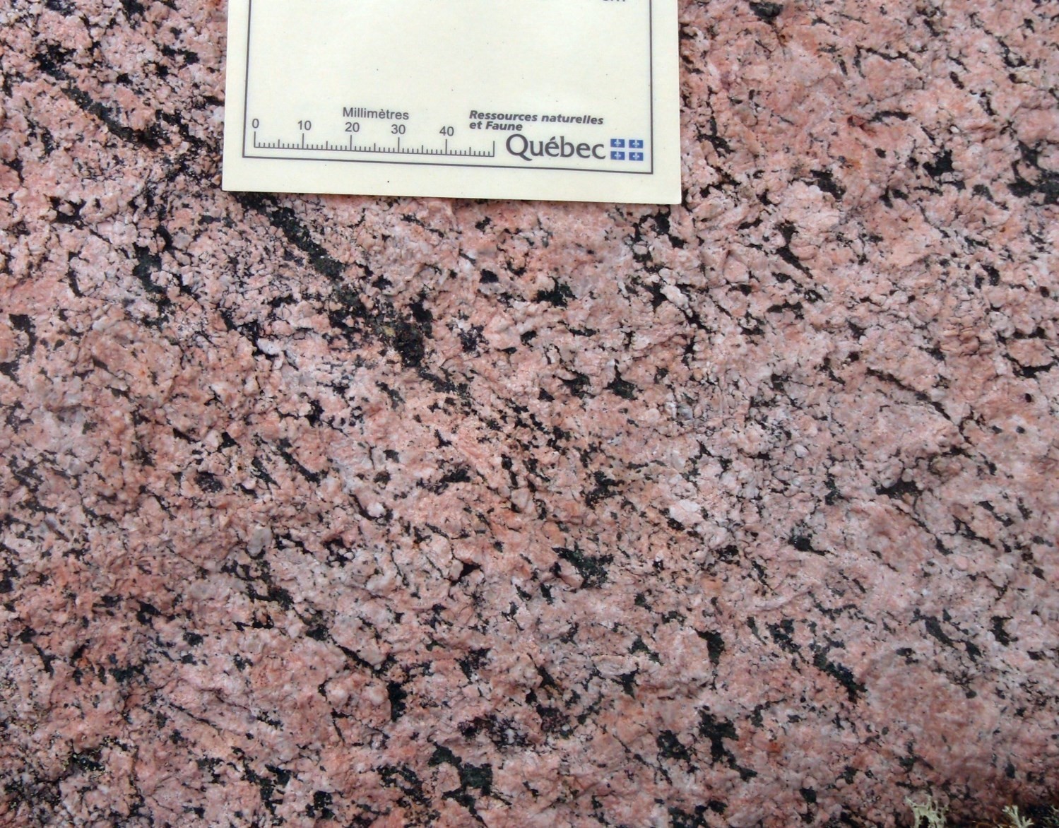
In the central part of the Baleine Domain, Archean potassic intrusions of the Saffray Suite (nAsaf; 2696-2683 Ma) are associated with strong regional E-W positive magnetic anomalies. This part of the Baleine Domain lies within the Superior Province’s Utsalik Domain extension, just west of the Labrador Trough. In the Superior Province, similar magnetic anomalies, also oriented E-W, are associated with the presence of large late Archean potassic intrusions, including the Maurel Suite (2707-2686 Ma; Simard et al., 2008). The latter consists of granodiorite, quartz monzodiorite and porphyraceous hornblende-biotite granite. These compositional, geochronological and textural similarities between intrusions of the Saffray and Maurel suites support the hypothesis of Wardle et al. (2002). These authors argued that the Baleine Domain could represent a block detached from the Superior Province.
Archean Supracrustal Rocks
In the central part of the Baleine Domain, a major partial melting event affected paragneiss of the False Suite (nAfas) in the Paleoproterozoic, resulting in the production of a significant amount of diatexite and metatexite (Winnie Suite [pPwii]). Detrital ages obtained in the False Suite range from 3335 Ma to 2678 Ma (Godet et al., 2020a). Crystallization of the anatectic liquid in these two suites is estimated at between 1838 Ma (Davis et al., 2015) and 1807 Ma (Godet et al., 2020a). The positive E-W magnetic anomalies that characterize the Saffray Suite continue in the western Baleine Domain with slightly less intensity. These observations seem to indicate that the geophysical response of the Saffray Suite is progressively masked by the migmatitic supracrustal cover, which is interpreted as relatively thin at this location (Lafrance et al., 2014). The presence of the False and Winnie suites between Archean intrusions of the Saffray Suite also suggests that these units were buried together during a collisional event in the Paleoproterozoic.
The southern part of the Baleine Domain includes a sequence of metamorphosed arkose and arenite, the Grand Rosoy Suite (nAgy). In this area, this suite is interstratified with slightly migmatized paragneiss and amphibolites belonging respectively to the Akiasirviup (nAaki) and Curot (nApPcut) suites. These last two units are concentrated at the western edge of the domain and outcrop mainly in the northern and southern parts, whereas they form a thin strip in the central part. It is therefore not excluded that the northern, central and southern volcano-sedimentary sequences are in fact distinct units. According to Simard et al. (2013), the Akiasirviup and Curot suites may be more metamorphosed equivalents of Paleoproterozoic units of the Laporte Supersuite in the Rachel-Laporte Domain. Geochronological results obtained in the Grand Rosoy Suite, however, indicate that the detrital material comes solely from the erosion of Archean rocks, thus justifying their belonging to the Baleine Domain.
Paleoproterozoic Intrusive Rocks
The partial melting event associated with diatexites and metatexites of the Winnie Suite (pPwii) is contemporaneous to the emplacement of numerous intrusive suites between 1861 Ma and 1811 Ma.
The Aveneau Suite (pPavn) is the most important Paleoproterozoic intrusive unit. It has been mapped throughout the Baleine Domain, with the exception of its southern end. It is composed of whitish felsic intrusions whose appearance is similar to that of the leucosome of Qurlutuq Complex migmatites. These rocks are interpreted by Simard et al. (2013) as representing in part the final melting product of Ungava Complex gneiss. The crystallization age of the Aveneau Suite (1817-1811 Ma) is contemporaneous with crystallization of the anatectic liquid of Winnie Suite diatexites and metamorphism of Ungava Complex gneiss. Analyses of Proterozoic zircons without evidence of Archean nuclei give precise ages, but spread over a significant period (40 Ma). Davis et al. (2015) propose that this unit is the result either of crystallization that stretched over a long period of metamorphism, possibly in the deep crust, or of remobilization of slightly older Proterozoic rocks in association with an Archean component. The Aveneau Suite contains enclaves of older units, particularly the Ungava and Qurlutuq complexes and the Ralleau and False Suites. In many places, intrusions of the Aveneau Suite intrude as decimetric to decametric sills into older rocks.
The De Pas Supersuite, a polyphase syntectonic intrusion that extends across the entire George Lithotectonic Domain to the east, also outcrops along the eastern edge of the Baleine Domain. In the NE part of the Baleine Domain, it forms a ~30 km wide intrusive mass.
Intrusive units of the Kaslac Complex (pPkaa), Tasialuk Suite (pPtak) and Kuujjuaq Pluton (pPkuu) were emplaced within gneiss of the Ungava Complex or paragneiss of the False Suite. The Kaslac Complex consists of a complex package of gneissic to mylonitic intrusive rocks. Rocks of mainly intermediate composition commonly contain orthopyroxene. To the west, the Kaslac Complex is in tectonic contact with volcano-sedimentary rocks of the Akiasirviup and Curot suites through the Gabriel Fault. The other two units form small intrusions. Porphyraceous felsic intrusive rocks of the Tasialuk Suite are located along the Gabriel Fault and cut units of the Kaslac Complex and False Suite. The Kuujjuaq Pluton forms a ~12 km long elliptical intrusion within paragneiss of the False Suite.
Potassic felsic intrusions of the Champdoré Suite (pPchm) are bounded to the west by the Lac Turcotte Fault, while intermediate to mafic intrusions of the Lhande Suite (pPlnd) are located directly north of the Champdoré Suite. These two units intrude into migmatized metasedimentary rocks of the False and Winnie Suites. The Baleine Domain also includes some minor circular or elliptical intrusions a few kilometres in diameter. At the southern end of the domain, the Gamelin Enderbite (pPgin) groups three intrusive masses that cut units of the Griffis Complex. In the north-central area, the Chaumaux Pluton (pPchu) comprises two anorthositic intrusions within the Qurlutuq Complex. The Potel Gabbro (pPpot) represents a slightly deformed intrusion that has been emplaced within paragneiss and paraschist units of the Akiasirviup Suite, at the southern end of the Baleine Domain.
Finally, the Dancelou Suite (pPdac) is the youngest Paleoproterozoic unit (1793-1748 Ma) of the Baleine Domain. It consists of slightly deformed granitic intrusions which form well circumscribed kilometric plutons scattered throughout the domain or which intrude as dykes into older units. Like the Aveneau Suite, the Dancelou Suite commonly contains enclaves of the surrounding units.
Mesoproterozoic Intrusive Rocks and Dykes
The Soisson Suite (mPsoi) comprises five undeformed and unmetamorphosed intrusions of troctolite, olivine gabbro and gabbronorite. These subophitic mafic rocks have a similar appearance to the dykes described below, but rather form kilometric intrusive masses. They cut the Ungava Complex and the Saffray, Winnie, Aveneau and Dancelou suites.
The whole SECP is cut by different swarms of mafic dykes, having ophitic or subophitic texture, grouped according to their orientation. These dykes cut across all units of the SECP and extend beyond the limits of lithotectonic domains. Two swarms of dykes have been observed in the Baleine Domain. A dozen <3 km long olivine gabbro dykes, oriented NNW-SSE, has been assigned to the Falcoz Swarm (mPfal) in the northern part. A single ENE-WSW oriented olivine gabbro dyke belonging to the Harp Dykes (mPhar) has been described in the southern part. It cuts the Griffis Complex and the Akiasirviup and Grand Rosoy suites along ~14 km in length.
Metamorphism
Metamorphic rocks are the dominant lithologies of the Baleine Domain. Almost all of them were metamorphosed in the Paleoproterozoic (Machado et al., 1989; Perreault and Hynes, 1990; Godet et al., 2020a). Nevertheless, a metamorphic age of 2809 Ma (Augland et al., 2016) obtained in the Qurlutuq Complex indicates the occurrence of an Archean migmatization event. However, evidence of this Archean regional metamorphism has been almost entirely obliterated by the Paleoproterozoic event (Moorhead, 1989; Poirier, 1989; Goulet, 1995).
The dominant metamorphic imprint of the domain was acquired during the erection of the New Quebec Orogenesis, active from 1836 Ma (Godet et al., 2020a) to 1760 Ma (Machado et al., 1989), and resulting from the oblique collision of the SECP with the Superior Craton (Wardle et al., 2002). Rocks affected by this event show an eastward progression in metamorphic intensity from greenschist facies in the Labrador Trough to granulite facies in the Baleine Domain (Moorhead, 1989; Poirier, 1989; Perreault and Hynes, 1990; Clark and Wares, 2004; Simard et al., 2013; Charette et al., 2016; Godet et al., 2017).
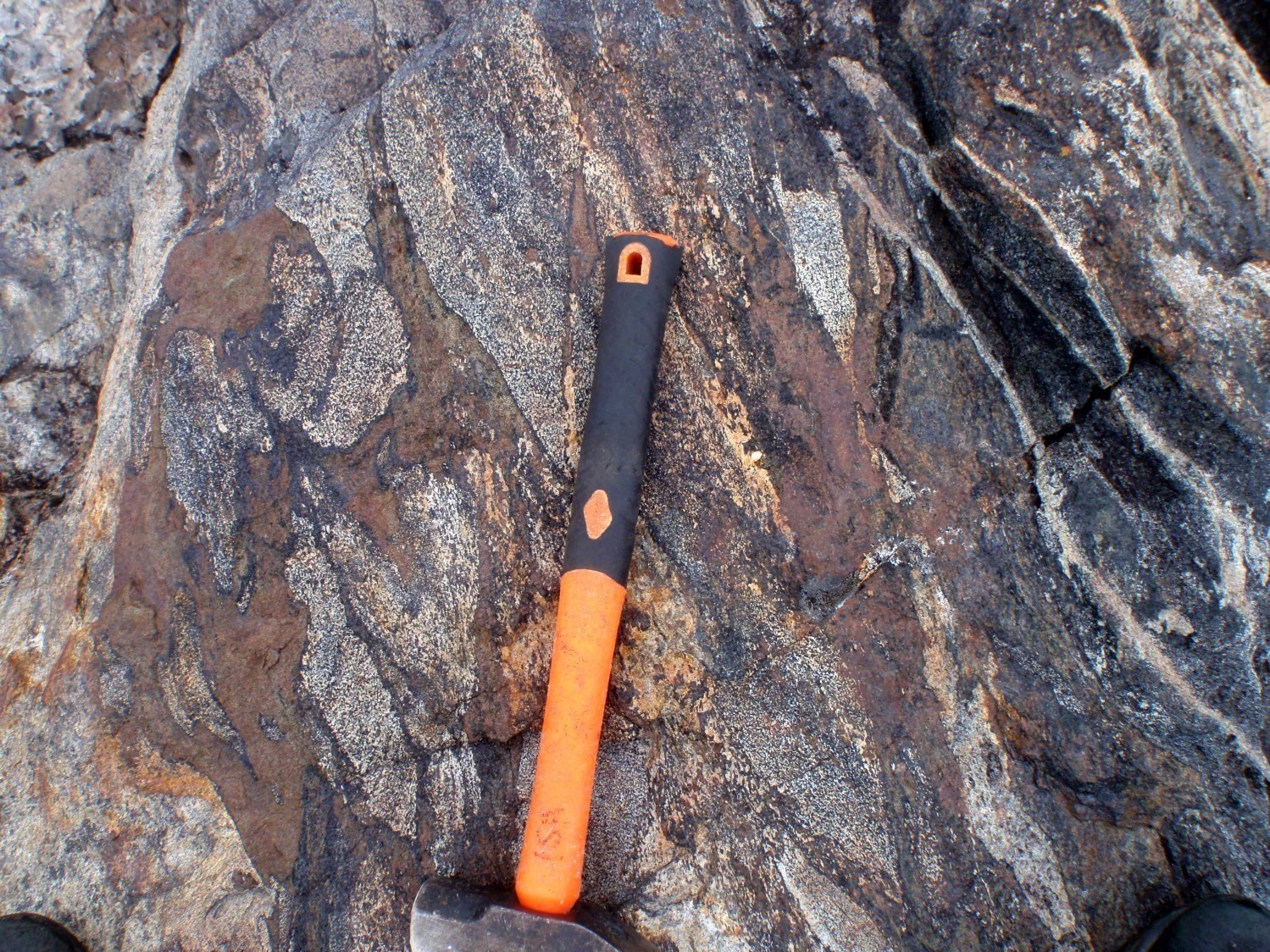
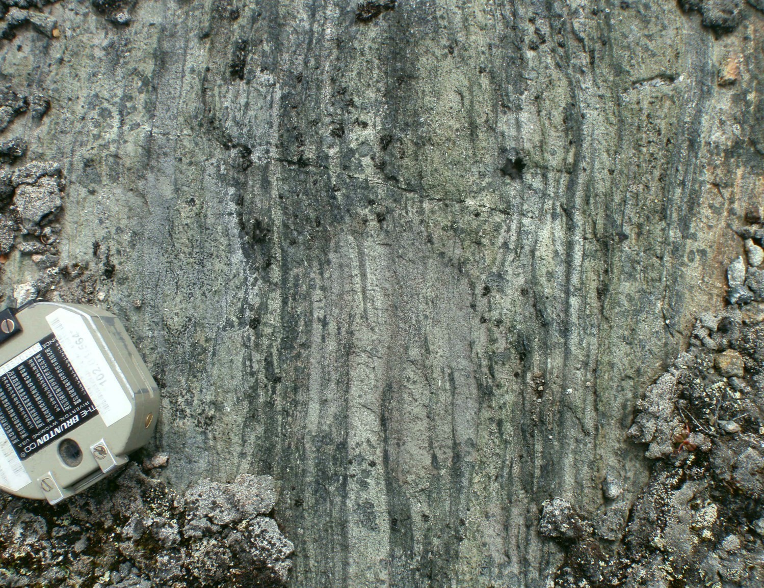
The relay fault system of Olmstead and Turcotte lakes, which represents the western limit of the Baleine Domain, has a significant influence on the metamorphic zonation of the New Quebec Orogen. This structure generally marks a boundary between a less metamorphosed domain in the west and the reaching of anatexis conditions in the east (Charette et al., 2016; Godet et al., 2020a). Indeed, rocks of the Akiasirviup Suite, located at the western edge of the Baleine Domain, display skeletal muscovite crystals adjacent to pseudomorphs of anatectic liquid (Charette et al., 2016). The isograde associated with the disappearance of muscovite is located further east, at the boundary between the Akiasirviup and False suites (Charette et al., 2016). In the Kuujjuaq area, this limit corresponds to the Gabriel Fault (Simard et al., 2013). Parageneses observed in the False Suite are quartz-plagioclase-biotite ± garnet ± sillimanite ± hornblende. Muscovite is rarely present. Diatexites and metatexites of the Winnie Suite have a similar paragenesis to that of the False Suite, in addition to microcline phenocrystals and, locally, kyanite (unit pPwii2). Generally speaking, migmatites of the Winnie Suite occupy the territory east of the False Suite. Gneiss of the Ungava Complex are also migmatized. Several samples from this complex contain zircons dated between 1864 Ma and 1786 Ma which are associated with either migmatization or metamorphism. In addition, tonalite and white schlieren granite of the Aveneau Suite are partly interpreted as the result of regional partial melting (Simard et al., 2013). Thus, geological mapping of the northern and central parts of the Baleine Domain reveals a very significant volume of migmatites and a general increase in the rate of partial melting towards the east. The presence of such a volume of migmatites implies generalized metamorphism that has minimally reached the upper amphibolite facies, and possibly even the granulite facies (Simard et al., 2013, Lafrance et al., 2014; Charette et al., 2016).
The southern end of the domain is characterized by the absence of partial melting in metasedimentary rocks of the Grand Rosoy Suite. The quartz-plagioclase-muscovite-biotite ± sillimanite paragenesis is representative of the amphibolite facies. The metamorphic gradient in this area is also greater, as demonstrated by the narrow transition (<10 km) from the amphibolite facies recorded by Grand Rosoy Suite rocks to the granulite facies in orthopyroxene gneiss of the Knox Complex.
Metamorphic modelling studies have allowed estimating the pressure and temperature conditions associated with metamorphic paroxysm in the northern (Poirier, 1989; Perreault and Hynes, 1990) and central (Godet et al., 2017, 2020a) sections of the Baleine Domain. In the northern sector, metamorphic paroxysm conditions are estimated to be around 800°C to 850°C and 0.6 GPa to 0.8 GPa. In the central part, a mafic rock sample recorded a temperature of 790°C and a pressure of 0.72 GPa (Godet et al., 2020a). These values confirm that the granulite facies has been reached. The study of Godet et al. (2017) also corroborates the increase in metamorphism intensity eastward, from the Rachel-Laporte Domain to the Baleine Domain, confirming the previous work mentioned above. Moreover, these elements combined with geochronological data allow defining the P-T-t path of metamorphic rocks in the Baleine Domain (Godet et al., 2020a). Thus, the garnet age at 1836 ±18 Ma, obtained in a garnet amphibolite lens within paragneiss of the False Suite, corresponds to the metamorphic paroxysm. An isothermal decompression follows and zircon crystallization at 1807 ±4 Ma indicates a return to subsolidus conditions (Godet et al., 2020a). The observation of rims of post-kinematic plagioclase-clinopyroxene symplectites around garnet supports this hypothesis (Groppo et al., 2007; Godet et al., 2020a). Plagioclase-hornblende or plagioclase-clinopyroxene symplectites around garnets have also been noted in the Kaslac Complex (Lamirande et al., 2016). The retrograde trajectory associated with isothermal decompression is characteristic of the Baleine Domain’s metamorphism and distinguishes it from the Mistinibi-Raude and Falcoz lithotectonic domains in the east. The latter also underwent granulite facies metamorphism, but this was followed by slow exhumation associated with erosion (Charette, 2016; Godet et al., 2020b; Godet, 2020).
Lithogeochemistry
The lithogeochemistry of units of the Baleine Domain is presented separately in tabular form.
Structural Geology
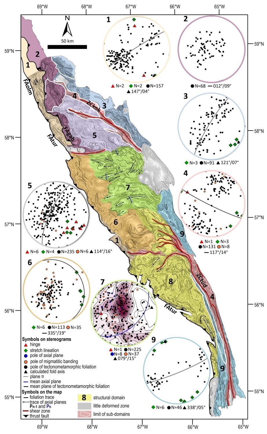
The Baleine Lithotectonic Domain is divided into nine structural domains defined according to stratigraphic units present and their structural style. The main fabrics are presented in chronological order for each of the structural domains, and are then related in the context of the structural evolution of the SECP.
Domain 1 is dominated by paragneiss of the Akiasirviup Suite. It is bounded to the west by the dextral Lac Turcotte and Lac Olmstead thrust faults (Poirier, 1989; Perreault and Hynes, 1990; Goulet, 1995). The main fabric of this domain corresponds to a foliation generally parallel to compositional banding or gneissosity. The distribution of foliation poles on the stereogram suggests that it is affected by NW-SE folds overturned towards the SW. Local kilometre-scale folds affecting foliation are evidence of this deformation phase.
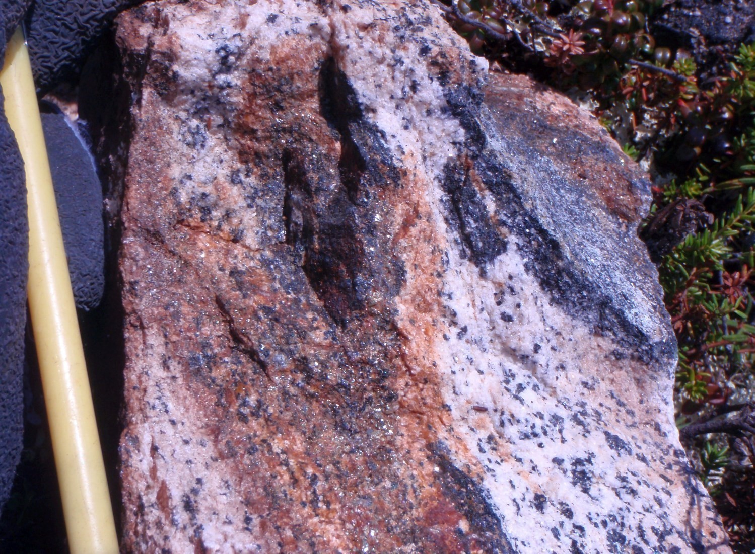
Domain 2 mainly groups gneissic to mylonitic rocks of the Kaslac Complex. It is bordered to the west by the Gabriel Fault (FAgab), interpreted as a reverse dextral structure dipping eastward (Simard et al., 2013). The aeromagnetic pattern and foliation traces draw elliptical shapes with centres showing a disordered arrangement. Foliations measured in a subdomain (delimited in white in the figure) characterized by a disordered aeromagnetic pattern are slightly dipping and of variable orientation. At the edges of these elliptical shapes, foliations are more inclined with better defined traces. The best circumscribed elliptical structures are associated with intrusions of ferriferous metagabbro of the Kaslac Complex, which offer a pronounced rheological contrast with surrounding felsic to intermediate felsic gneiss. It is possible that progressive deformation in these zones of high rheological contrast favoured the formation of vertical long axis sheath folds by active folding (Reber et al., 2012). Coronitic textures and metamorphic decompression reactions observed within metagabbro suggest rapid exhumation and are compatible with the presence of structures stretched along a vertical axis.
Domain 3 corresponds approximately to Domain 5 of Simard et al. (2013). It occupies a section dominated by gneiss of the Ungava Complex and migmatites of the Qurlutuq Complex. This area is characterized by folds shallowly to moderately dipping towards the SE (Simard et al., 2013). Stretch lineations of the NW part of Domain 3, SE oriented and subhorizontal, coincide with the calculated fold axis.
Domain 4 groups the most important shear zones of the Baleine Lithotectonic Domain. Its aeromagnetic signature is characterized by pronounced banding corresponding to foliation traces. Lithological units are affected by intense foliation, commonly mylonitic. In the southern half of Domain 4, the Lac Tudor Shear Zone (ZCtud) forms the eastern boundary of the Baleine Domain. This dextral transpressive structure (van der Leeden et al., 1990) is characterized by subvertical foliation and subhorizontal stretch lineations. The Koksoak Shear Zone (ZCkok) is a newly defined structure which delimits structural domains 3 and 5. The zone of influence of the ZCkok was outlined using aeromagnetic maps (D’Amours and Intissar, 2012a, b, 2013a, b; Intissar et al., 2014) and corresponds to an area marked by continuous banding parallel to the orientation of measured foliations. It is cut at its SE end by a slightly deformed section of the De Pas Granitic Suite. Several intensely deformed outcrops were observed along the ZCkok. However, no information is available on the associated kinematics. The mean foliation plane is oriented ESE and subvertical with subhorizontal stretch lineations of the same orientation. The attitude of the main fabrics in the ZCkok is therefore similar to that of the ZCtud. Two E-W shear zones have also been included in Domain 4. They are recognizable due to the presence of a few intensely deformed outcrops and the interpretation of the aeromagnetic pattern that demonstrates the existence of narrow corridors associated with regular E-W foliation. These structures also correspond to major lithological discontinuities at the scale of the Baleine Domain between the northern, central and southern sections (see the Stratigraphy section). However, the available structural data is insufficient to define their main characteristics.
Domain 5, located SW of the ZCkok, consists mainly of massive to foliated tonalite of the Aveneau Suite intruding into gneiss of the Ungava Complex. Its aeromagnetic signature is diffuse and disorganized and makes it difficult to draw structural lineaments. Measured foliations are mostly shallowly dipping towards the SE and are preferentially distributed along a great circle whose pole corresponds approximately to the measured fold hinges and stretch lineations. It is therefore a domain characterized by open folds slightly dipping towards the SE. It is not possible to determine whether these are straight or overturned.
The Winnie and False suites make up the major part of Domain 6. Foliations and migmatitic banding of these rocks are mainly oriented towards the NNW and have a slight dip towards the NNE. Stretch lineations have a slight NE to SE plunge. The transition with Domain 7 is diffuse and corresponds to the presence of elliptical structures of E-W axis associated with the Saffray Suite. It is not excluded that these structures represent an Archean heritage since they are in the extension of geophysical lineaments observed in the Superior Province (see Regional Tectonics section). Folioation traces and axial planes defining ellipses are folded by open N-S folds, so that the general arrangement of Domain 7 corresponds to an intermediary between interference patterns of type I and II folds of Ramsay and Huber (1987). This type of interference implies the presence of overturned folds, which is validated by measurements of axial planes moderately dipping towards the SE. The maximum of foliation poles coincides with that of axial planes, suggesting that these foliations are affected by tight folds dipping towards the NW. Straight, open N-S folds could be responsible for the dispersion of foliation measurements.
Domain 8 encompasses a diversity of Archean to Paleoproterozoic lithologies. Foliation traces define a complex arrangement of domes and basins or crescents interpreted as the result of superimposed folds. The edges of these structures are often delimited by subvertical E-W to NW-SE shear zones which join the ZCtud. The interference pattern of crescent folds (Ramsay and Huber Type II, 1987) is dominant in the southern part of the domain; furthermore, the FAtur is folded in the same arrangement. Domain 9 is located at the edge of the ZCtud. The foliations there are subvertical and affected by tight to isoclinal Pn folds whose calculated axis is subhorizontal and subparallel to N-S stretch lineations.
In Domain 8, Pn-1 folds overturned towards the NW affect Paleoproterozoic rocks of the Champdoré Suite. In the Rachel-Laporte Lithotectonic Domain, folds of similar geometry to those of Domain 7 are present in the Rénia Complex. According to Moorhead and Hynes (1990), these folds are associated with thrusting of the Archean Baleine basement towards the SW on the Rachel-Laporte Domain during the New Quebec Orogenesis. Thus, tight, overturned Pn-1 folds of Domain 7 could be contemporaneous with those affecting the Rénia Complex. Similarly, Pn-1 folds in Domaine 8 are interpreted as being associated with thrusting of the Baleine Domain on the Rachel-Laporte Domain in a system of folds and thrust zones. This interpretation is supported by the fact that this domain displays the same crescent-shaped interference pattern, implying that the system of folds and thrust zones is repeated by N-S straight folds. Associated NW-oriented folds would have formed during a deformation phase Dn-1 during the construction of the New Quebec Orogen in the Baleine Domain.
Straight folds of N-S axis, open to the north and tight to isoclinal to the south, are identified Pn since they repeat P1 overturned folds. They are an important structural element, especially in Domain 9, where they are predominant. The correspondence between stretch lineations of Domain 9 with that of the ZCtud suggests that N-S oriented P2 folds are associated with the same deformation phase as that associated with the formation of this shear zone in dextral transpression. The ZCkok is cut to the south by a low deformation zone corresponding to the De Pas Supersuite. By extending the ZCkok through this low deformation zone, it joins the Rivière George Shear Zone (ZCrge). The ZCkok thus appears to be part of the extensive shear zone network comprising the Rivière George, Lac Tudor, Moonbase and Falcoz shear zones that would have formed as a result of compression along a WSW-ENE axis (Vanier, 2019). This network of shear zones extends into the Baleine Domain and is older than part of the De Pas Supersuite.
The main factories of domains 1, 2, 3, 5 and 6 are difficult to correlate at the scale of the Baleine Domain. However, the correspondence between migmatitic banding and foliations of Domain 6 suggests that deformation is contemporaneous to partial melting, the latter dated between 1838 Ma (Davis et al., 2015) and 1807 Ma (Godet et al., 2020a) in the Winnie and False suites.
Regional Tectonics
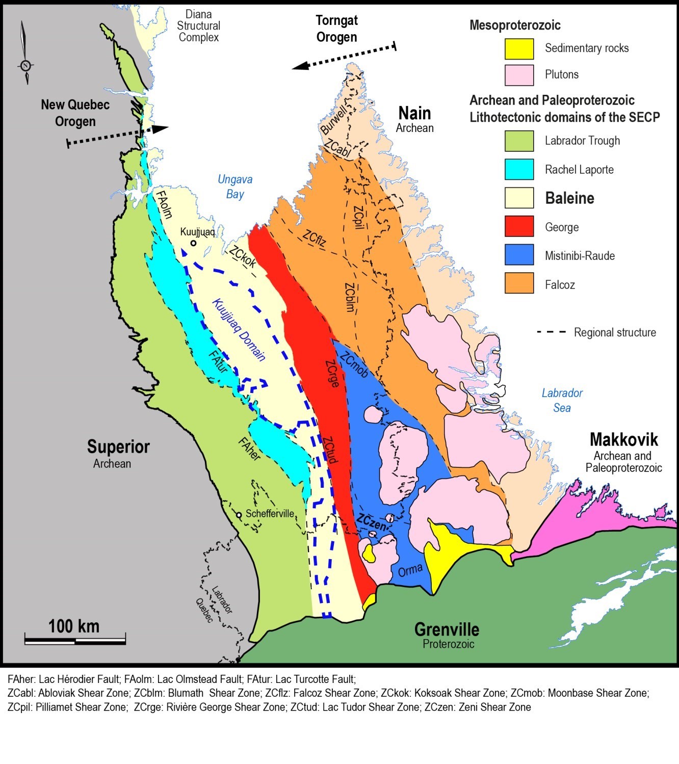
The SECP was divided into lithotectonic domains characterized by distinct tectonic evolution (James and Dunning, 2000; Corrigan et al., 2018). While the history of some domains is well documented (Corrigan et al., 2018; Godet et al., 2020b), the history of the Baleine Domain is still poorly understood, particularly with respect to the events prior to the New Quebec Orogenesis that are the basis of these subdivisions (Corrigan et al., 2018). The Baleine Domain here includes the “Kuujjuaq Domain” defined by Wardle et al. (2002) and Corrigan et al. (2018). The latter represents a little-known entity comprising important Archean units (Ungava and Qurlutuq complexes, and Saffray and False suites). Its extension towards the north is little discussed by these authors. According to them, it could extend as far as the interpreted intersection of the Lac Tudor Shear Zone (ZCtud) and Lac Turcotte Fault.
This synthesis questions the northern extension of the ZCtud and, consequently, the location of the northern limit of the “Kuujjuaq Domain” and, consequently, of the Baleine Domain. If such a boundary exists, it would lie further north and coincide with the Koksoak Shear Zone (ZCkok). Thus, the bedrock to the NE of the Koksoak Shear Zone could belong to the George Domain. However, it cannot be said that the Archean rocks on either side of this structure have undergone a distinct tectonic evolution, since of the dominant Archean stratigraphic units in the Baleine Domain, only the Saffray Suite is confined to the SW of the ZCkok.
A comparison of the ages emplacement of gneissic bedrock within the Baleine Domain (Ungava and Qurlutuq complexes) with those of similar units in the George Domain (Saint-Sauveur and Guesnier complexes) may help to better circumscribe these lithotectonic subdivisions. The eight ages obtained to the north of the “Kuujjuaq Domain” – the area considered to be the continuation of the George Domain by Corrigan et al. (2018) – range from 2843 Ma to 2701 Ma (Machado et al., 1989; Davis et al., 2014; Corrigan and McFarlane, 2017, pers. comm.; Davis and Sutcliffe, 2018b), while within the “Kuujjuaq Domain” only two crystallization ages (2656 Ma [David, 2020] and 2666 Ma [Corrigan and McFarlane, 2017, pers. comm.]) are available. In the George Domain, the ages obtained are also Neoarchean, ranging from 2687 Ma to 2663 Ma (Davis et al., 2014; Corrigan et al., 2018; David et al., in preparation).
At first glance, the gneissic bedrock to the north of the “Kuujjuaq Domain” seems older than gneiss located within it or in the George Domain. However, the scarcity of geochronological data in the latter two areas, compared to the area north of the “Kuujjuaq Domain”, may explain the lesser age spread. Current data does not allow us to conclude that the northern part of the “Kuujjuaq Domain” and the George Domain share a common origin.
The preferred hypothesis regarding the evolution of the “Kuujjuaq Domain” is that it represents the rifted margin of the Superior Craton (James and Dunning, 2000; Wardle et al., 2002; Rayner et al., 2017; Godet et al., 2020a). Various arguments support this hypothesis: 1) the similar ages of the Saffray Suite (2696-2693 Ma) and the Maurel Intrusive Suite (2707-2686 Ma) of the Superior Province; 2) the similarities in the composition of these two suites (see the Stratigraphy section); and, 3) the E-W oriented geophysical lineaments associated with the Saffray Suite that could correspond to the extension of structures present in the Superior Province (Wardle et al., 2002; Lafrance et al., 2014).
Similarly, the northern part of the Baleine Domain (north of the “Kuujjuaq Domain”) could partly represent the continuity of the Douglas Harbour Domain of the Superior Province, which is characterized by large tonalite units (see the Stratigraphy section). However, the tectonic evolution of the Baleine Domain in the Archean remains much less understood than that of the New Quebec Orogen in the Paleoproterozoic. The latter episode affected the entire Baleine Domain, which supports the decision to unify this vast territory within a single domain.
The work on metamorphic modelling and petrochronology by Godet et al. (2020a), carried out in the central part of the Baleine Domain, allows interpreting and describing three phases of tectonic evolution associated with the emplacement of the New Quebec Orogen. During the collision with the George Domain, the Baleine Domain was first buried and underwent metamorphism reaching the granulite facies. The second phase involves thrusting of Baleine Domain on the Rachel-Laporte Domain along the Lac Turcotte Fault, resulting in isothermal decompression in the Baleine Domain, as well as the burial of rocks of the Rachel-Laporte Domain and their metamorphism to the amphibolite facies. Finally, these two juxtaposed domains were gradually exposed at their current level by erosion. This model implies that the Lac Turcotte Fault represents a significant metamorphic discontinuity that is revealed by the metamorphic diachronism between the Baleine and Rachel-Laporte domains, rather than by a gradient observed in the field that would reveal a gradual increase in the intensity of metamorphism. However, the information available on this key structure of the New Quebec Orogen is limited, as it is rarely exposed.
Economic Geology
The Baleine Lithotectonic Domain is a prospective area for several types of mineralization:
- Magmatic and hydrothermal Ni-Cu (± PGE ± Au ± Co) mineralization associated with mafic to ultramafic intrusive rocks;
- Magmatic V-Fe-Ti mineralization in mafic intrusive rocks;
- Cu-Au-Mo mineralization associated with porphyry intrusive rocks;
- Vein and epithermal mineralization associated with mafic to felsic volcanic rocks;
- Rare metal mineralization associated with hyperalkaline rocks and pegmatitic granites;
- Mineralization associated with sedimentary rocks.
The table of mineralized zones below presents analytical results for the 44 known mineralized zones in the area.
| Name | Contents |
|---|---|
| Mineralization Associated with Cu-Au-Mo Porphyry Intrusive Rocks | |
| Baleine | 13 250 ppm Cu over 0.5 m (R); 8.54 ppm Ag over 0.5 m (R) |
| Champdoré Sud | 10.8 ppm Ag (G); 42.7 ppm Th (G) |
| Lac Champdoré – 1 | 9963 ppm Cu (G); 5.7 ppm Ag (G); 262 ppb Au (G) |
| Lac Champdoré – 2 | 23 900 ppm Cu (G); 37 ppm Ag (G); 1850 ppb Au (G) |
| Lac Champdoré – 2-Mo | 1640 ppm Mo (G) |
| Mineralization Associated with Granitic Pegmatites | |
| Cible-5 | 1380 ppm U (G); 195 ppm Th (G) |
| Coude Sangumanialuk-Est | 1400 ppm Th (G); 948 ppm REE (G) |
| Coude Sangumanialuk-Ouest | 3015 ppm REE (G); 1010 ppm Th (G) |
| Urani-22 | 3244.8 ppm REE (G); 916 ppm Th (G); 2410 ppm U (G); 332 ppm Y (G); 1340 ppm Pb (G); 378 ppm Mo (G) |
| Urani-Est | 2110 ppm U (G); 802,5 ppm REE (G); 432 ppm Th (G) |
| Urani-NE | 2988.9 ppm REE (G); 815 ppm Th (G) |
| Urani-Ouest | 1630 ppm U (G) |
| Rare Metal Mineralization Associated with Hyperalkaline Rocks | |
| Siurivvik | 2349.49 ppm REE (G); 1442 ppm Sr (G); 5.68% P2O5 (G) |
| Magmatic V-Fe-Ti Mineralization in Mafic Intrusive Rocks | |
| Potel | 1691 ppm V (G); 31.81% Fe2O3t (G); 5.27% TiO2 (G) |
| Kaslac | 1448 ppm V (G); 22.77% Fe2O3t (G); 680 ppm Cu (G) |
| Magmatic and Hydrothermal Ni-Cu ± PGE ± Au Mineralization Associated with Mafic to Ultramafic Intrusive Rocks | |
| Grand Rosoy 1 | 23 000 ppm Cu over 1 m (R) |
| A14-1E | 7850 ppm Ni over 1.4 m (R); 4640 ppm Cu over 1.4 m (R); 540 ppm Co over 1.4 m (R); 94 ppb Pd (G) |
| A14-1W | 6339 ppm Ni (G); 2640 ppm Cu (G); 2.3 ppm Ag over 0.2 m (D); 440 ppm Co (G) |
| A17-1 | 3028 ppm Ni (G); 2927 ppm Cu (G); 4 ppm Ag (G) |
| Papavoine | 12 655 ppm Ni over 0.2 m (D); 11 200 ppm Cu (G); 13 005 ppm Zn over 0.4 m (D); 10.7 ppm Ag over 0.4 m (D); 181 ppb EGP (G); 1096 ppm Co over 0.2 m (D) |
| Papavoine Ouest | 5774 ppm Ni over 1 m (D); 4857 ppm Cu over 0.7 m (D); 1 ppm Ag over 0.7 m (D) |
| Papavoine Ouest – QPD01007 | 3875 ppm Ni over 1 m (D); 2620 ppm Cu over 1 m (D); 3310 ppm Zn over 0.5 m (D); 4.8 ppm Ag over 0.5 m (D) |
| Papavoine Sud | 7081 ppm Ni over 0.1 m (D); 1738 ppm Cu over 1 m (D); 1418 ppm Zn over 0.1 m (D); 424 ppm Cr over 0.1 m (D); 916 ppm Co over 0.1 m (D); 1.5 ppm Ag over 0.1 m (D) |
| Cu ± Au ± Ag ± Ni Vein Mineralization in Metavolcanic Rocks | |
| Couture | 650 000 ppm Cu (G); 420 ppm Ag (G); 950 ppb Au (G); 2400 ppm Se (G) |
| Couture Nord | 8015 ppm Cu (G) |
| Couture Sud | 15 000 ppm Cu (G); 1.4 ppm Ag (G) |
| Céline | 12 140 ppm Cu (G); 7.9 ppm Ag (G); 434,1 ppm Ni (G) |
| Ivik | 3170 ppm Ni (G) |
| Lac Uni | 5567 ppm Cu (G) |
| Niviaxie | 17 450 ppb Au (G); 13 900 ppm Cu (G); 8.2 ppm Ag (G) |
| Niviaxie-2 | 18 600 ppm Cu (G); 33.4 ppm Ag (G); 256 ppb Au (G) |
| Niviaxie-Nord | 1365 ppb Au (G); 11 400 ppm Cu (G) |
| Niviaxie-Nord-2 | 13 900 ppm Cu (G); 8.1 ppm Ag (G) |
| TB2-3 | 53 000 ppm Cu (G); 7.4 ppm Ag (G) |
| Zone XII | 11 000 ppm Cu (G) |
| Zone XiX | 1552 ppb Au (G); 5435 ppm Cu (G); 2.8 ppm Ag (G) |
| Mineralization of Undetermined Type in Sedimentary Rocks | |
| Cap Jagged | 7 ppm Ag (G); 1000 ppm Cu (G); 820 ppm Zn (G); 720 ppm Ni (G) |
| Danis 3 | 2500 ppb Au (G) |
| Lac Recouet – 1 | 7105 ppm Cu (G) |
| Lac Recouet – 2 | 16 000 ppm Cu (G); 7.4 ppm Ag (G) |
| Souel | 10 ppm Ag (G) |
| Tibo | 5 ppm Ag (G); 460 ppm Cu (G); 340 ppm Zn (G) |
| Mineralization in Iron Formations | |
| Boubou | 324 000 ppm Fe (G) |
| Exhalative Sulphide Mineralization in Sedimentary Rocks (Sedex) | |
| Kavisililik | 52 200 ppm Pb (G); 3324 ppm Zn (G) |
(D): Diamond drilling; (G): Selected sample; (R): Groove – chip sample
The table of lithogeochemical analyses of metals of economic interest gives the location, description and analytical results for 152 samples selected to evaluate the economic potential of the area.
Magmatic and Hydrothermal Ni-Cu ± PGE ± Au Mineralization Associated with Mafic to Ultramafic Intrusions
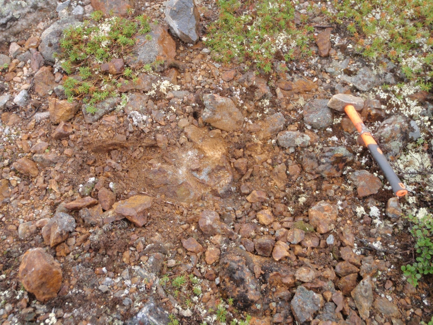
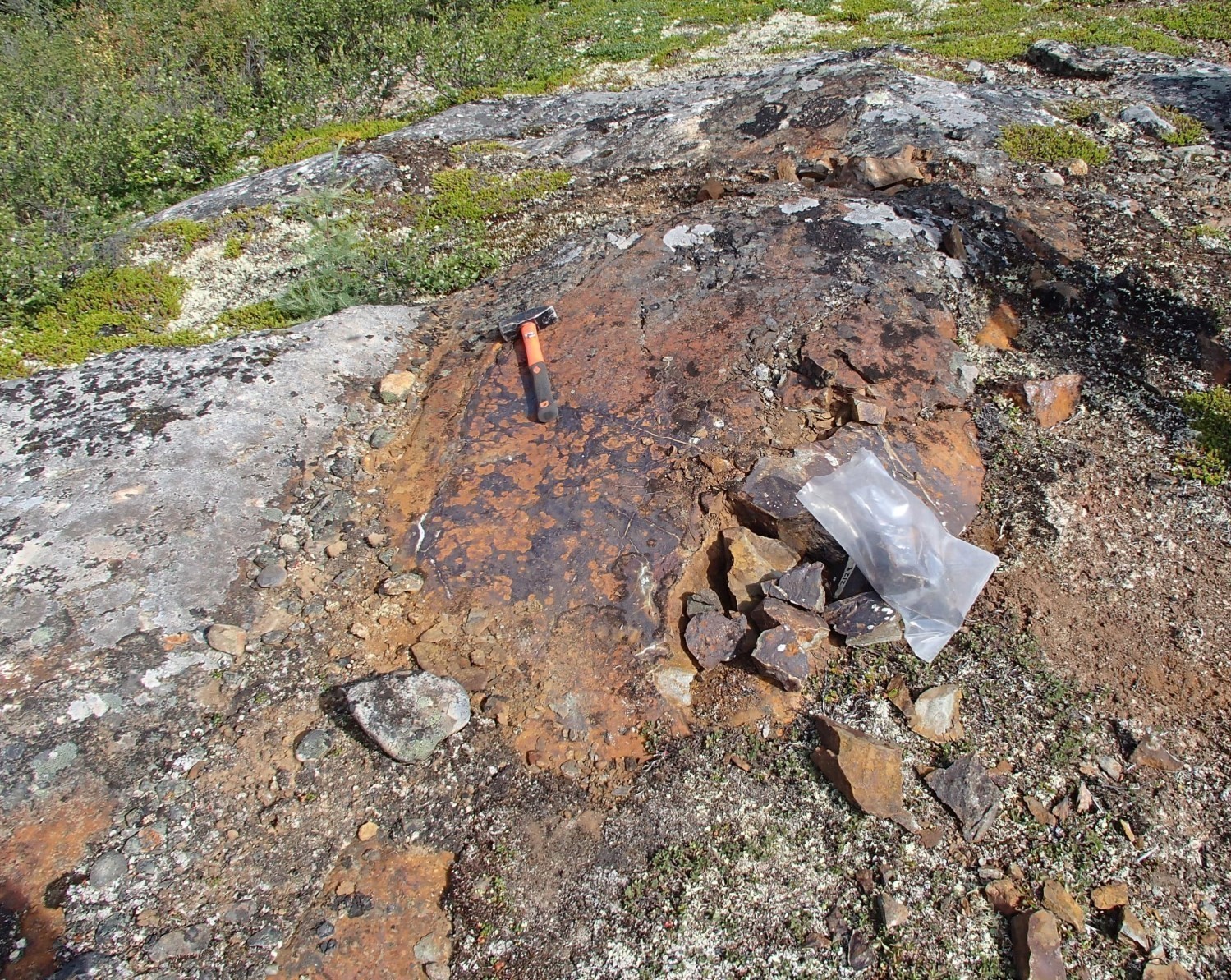
The Baleine Domain comprises units of mafic and ultramafic intrusive rocks prospective for Ni-Cu mineralization. Several rust zones containing sulphide mineralization observed within the Kaslac Complex and the Soisson, Ralleau and Lhande suites have returned anomalous contents of these elements. These zones are also commonly associated with the presence of lake bottom geochemical anomalies and spatial regression targets for nickel, copper or gold (Lamothe, 2009).
 Undeformed kilometric mafic intrusions of the Soisson Suite also represent a prospective zone. The southernmost intrusions contain seven mineralized zones, including the Papavoine mineralized zone, where the best contents were obtained (1.27% Ni and 1.12% Cu; Deveau et al., 2001). Metric to decametric rust zones contain 5 to 35% sulphides and are observed at the base of sills, at the contact with the surrounding paragneiss. Mineralization (pyrrhotite, chalcopyrite and pentlandite) occurs in disseminated form, in clusters and millimetric veinlets in the mafic intrusions and paragneiss, often graphitic (<10%). Although all the known mineralized zones are concentrated in the southernmost intrusions, Sappin et al. (2020) mention that all the intrusions in this suite follow the same evolutionary trends and are therefore considered to be cogenetic and prospective for Ni-Cu mineralization. Furthermore, these authors also indicate that the petrography, mineral chemistry and geochemical composition of rocks of the Soisson Suite display similarities with troctolite and olivine gabbro cumulates of the Voisey’s Bay intrusion (Nain Plutonic Suite). Although slightly younger than the latter (1335-1331 Ma; Amelin et al., 1999), a genetic link is possible between the Soisson Suite (1312 Ma; Corrigan et al., 2019) and the Nain Plutonic Suite.
In the Jeannin Lake area, a gabbronorite sample from the Lhande Suite, collected as part of the Ministère‘s work, also yielded anomalous contents in copper (1250 ppm Cu), nickel (640 ppm Ni) and gold (35 ppb Au). Outcrop 15-JC-5046, associated with a positive magnetic anomaly of ~4 km by 400 m, exposes a 50 cm wide rusted zone containing carbonate-pyrrhotite (1%) veinlets.
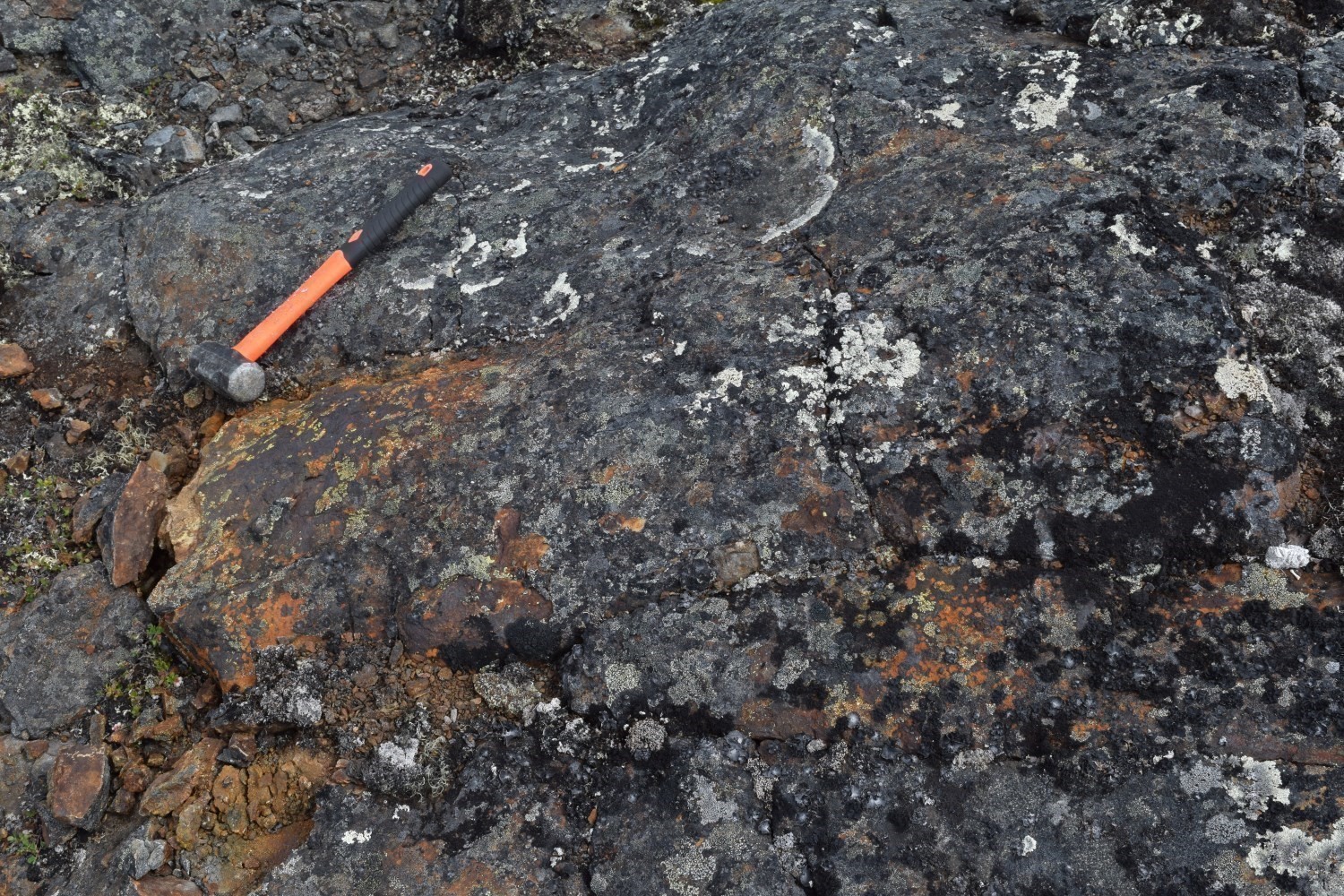
In the northern part of the Baleine Domain, gabbro and pyroxenite of the Kaslac Complex contain numerous decimetric to decimetric rusted zones that contain 1 to 10% sulphides (pyrrhotite-pyrite ± chalcopyrite) disseminated or in quartz-carbonate-epidote veinlets, suggesting that at least part of the mineralization would be late or remobilized. Several samples taken during the Ministère’s work within these rust zones revealed anomalous or significant contents in copper (<1305 ppm Cu) and interesting values un nickel (<490 ppm Ni) and gold (<215 ppb Au). Locally, rust zones are associated with the presence of hydrothermal alteration zones (albite, epidote or carbonate), for example at outcrops 11-PL-6171 and 11-CL-5214.
 In amphibolitized gabbro of the Ralleau Suite, mineralization is mainly related to hydrothermal processes. For example, at the Grand Rosoy 1 mineralized zone (2.3% Cu; Desbien, 1998), sulphides are disseminated in a stockwork of quartz-feldspar-malachite veinlets 4 to 5 m in diameter, but are also present within gabbro itself, suggesting that the mineralization associated with veinlets reflects remobilization of sulphides of possibly magmatic origin. The sulphides observed consist of pyrite, pyrrhotite and chalcopyrite with lesser amounts of bornite and covellite.
 Samples taken from various outcrops assigned to the Ralleau Suite also revealed anomalous copper contents (<720 ppm Cu), particularly at outcrops 16-BC-1054, 15-LP-2064, 11-CL-5168 and 15-IL-3181. Mineralization (<10% pyrrhotite <2% pyrite and <1% chalcopyrite) is mainly disseminated and in millimetric clusters within millimetric to decimetric quartz veins or in felsic or garnet mafic intrusions cutting gabbro.
Magmatic V-Fe-Ti Mineralization in Mafic Intrusions
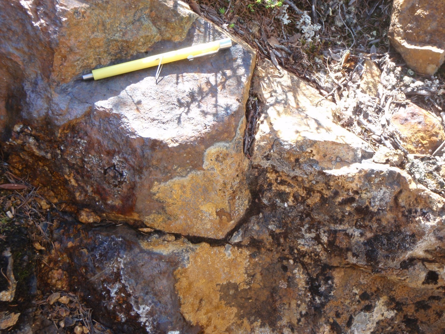
 In the northern part of the Baleine Domain, garnet porphyroblastic ferriferous metagabbro of the Kaslac Complex (pPkaa2) is associated with two very strong annular magnetic anomalies of 4 km by 2.6 km and 8.5 km by 3 km. The southern anomaly represents a prospective zone for V ± Fe ± Ti mineralization of magmatic origin associated with mafic intrusions. Garnet-free gabbro, facies formed by lithologies ranging from anorthosite to melanogabbro and lenses of ultramafic rocks have also been observed in association with ferriferous metagabbro. A showing content (1448 ppm V; Kaslac mineralized zone) and nearly twenty anomalous contents in vandium (<1371 ppm V), commonly associated with significant titanium (<1.8% TiO2) and iron (<28.4% Fe2O3), were obtained in unit pPkaa2. These contents are related to the presence of magnetite (up to 10%), possibly vanadium-bearing, and locally ilmenite. In some cases, notably at the Kaslac mineralized zone, magnetic metagabbro also contains rust zones anomalous in copper (<680 ppm Cu) with disseminated pyrrhotite (~1%) and chalcopyrite (traces).
 The Gabbro de Potel, located at the southern end of the Domaine de Baleine, constitutes a second prospective zone for this type of mineralization. At the Potel mineralized zone (1691 ppm V; Hammouche et al., 2011), mineralization occurs in centimetric beds of disseminated to massive vanadium-bearing magnetite and ilmenite in coronitic melanogabbronorite.
Cu-Au-Mo Mineralization Associated with Porphyritic Intrusions
In the southern part of the Baleine Domain, in the vicinity of the Lac Turcotte Fault, a series of mineralized zones clustered within and along the edge of a potassic intrusion (Champdoré Suite) appears to indicate potential for Cu-Au-Mo porphyry mineralization. Their spatial association with vein-type mineralization injected into a metamorphosed sequence of volcanic and pyroclastic rocks (Curot Suite) could also represent a prospective context for epithermal Au-Cu-Ag mineralization. The Champdoré prospective zone comprises eight mineralized zones, four of which are within granodiorite. The Champdoré Suite is a polyphase intrusive unit composed of different facies of well foliated to gneissic intermediate to felsic rocks. The presence of 10 to 25% of K-feldspar phenocrystals is also characteristic of rocks of this unit.
 The best contents come from the Lac Champdoré – 2 mineralized zone (2.39% Cu, 37 g/t Ag and 1.85 g/t Au; Séguin, 2008) hosted in quartz monzodiorite. The uneven distribution of K-feldspar in monzodiorite could indicate potassic alteration. This mineral forms an interstitial phase that locally replaces plagioclase. Biotite is also slightly chloritized. The mineralized zone is ~15 m wide and contains disseminated sulphides associated with rusty and flattened centimetric to decimetric clusters. These quartz-hornblende-pistachite clusters are surrounded by an orange-brown alteration halo containing up to 15% cubic pyrite and trace chalcopyrite. Approximately 60 km to the NW, a similar intrusion includes a pyrite-chalcopyrite paragneiss layer yielding 2240 ppm Cu and 187 ppb Au (15-MP-1212). More work is required to verify the potential of the Champdoré Suite.
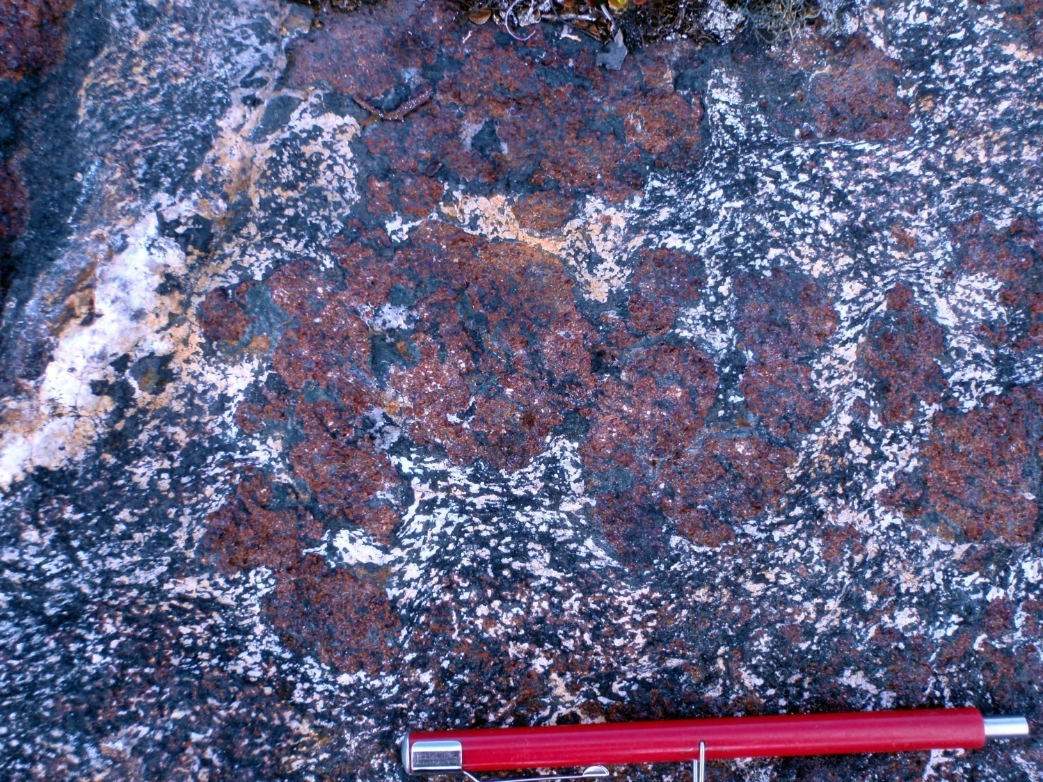
In a completely different area, in the northern part of the domain, the Baleine mineralized zone (1.3% Cu and 8.5 g/t Ag; Simard et al., 2013) appears to be associated with a potassic alteration zone (K-feldspar, biotite and sericite) at the contact between migmatite of the Qurlutuq Complex and amphibolitized diorite of the Ralleau Suite. Sulphide development would possibly be post-tectonic, in connection with the De Pas Supersuite (Brind’amour-Côté et al., 2017). The mineralized zone, composed of 5-10% pyrite, 1-5% chalcopyrite and traces of pyrrhotite, outcrops over ~30 cm wide and 10 m long. It is associated with silver lake bottom sediment anomalies (Lamothe, 2009).
Vein and Epithermal Mineralization Associated with Mafic to Felsic Volcanics
The Champdoré prospective zone, mentioned above, also includes four showings (Niviaxie, Niviaxie-2, Niviaxie-Nord and Niviaxie-Nord-2) located within a metavolcanic sequence of the Curot Suite. This sequence, ~3.5 km long by 300 m wide, consists of alternating decimetric to metric layers of intermediate, mafic and felsic composition. Several primary textures are preserved, such as pillows and scoriae. These rocks are strongly epidotized and carbonatized and are cut by aplitic and pegmatitic granite intrusions. Felsic rocks are rusty, but the showing contents appear to be more associated with mafic units where mineralization occurs as quartz veins mineralized in bornite, chalcocite, chalcopyrite and malachite (Séguin, 2008). These veins are oriented parallel to regional foliation and have an average thickness of 10 cm over a strike length of 30 cm to several metres (Séguin, 2008). Numerous erratic blocks also host similar mineralization in the area. The best contents from selected samples are 17.45 g/t Au, 1.86% Cu and 8.2 g/t Ag (Séguin, 2008).
 A second strip of the same size consisting of banded and (epidote and potassium feldspar) altered metavolcanic rocks was observed <500 m to the east. The two strips are separated by granodiorite of the Champdoré Suite which is affected at this location by a very strong subvertical lineation.
Approximately 50 km to the SSE of the Champdoré prospective zone, metavolcanics of the Curot Suite also contain several showings. Cu-Ag-Au mineralization is mainly associated with sulphide ± quartz ± plagioclase ± pyroxene ± magnetite veins and veinlets cutting decimetric layers of rusty amphibolite. Their emplacement is probably due to the remobilization of exhalative-type sulphides. Four of these zones (Couture, Couture Nord, Couture Sud and Lac Uni) are distributed along a 12 km long positive magnetic lineament. This lineament is associated with a shear zone oriented ~N-S. At the Couture zone, selected samples yielded up to 65% Cu, 420 g/t Ag and 0.95 g/t Au (Desbiens, 1998). Sulphides are disseminated or form centimetric clusters in the veins and in amphibolite. The main metallic minerals are digenite, chalcocite, hematite and brochantite. Smaller amounts of bornite and covellite, as well as traces of malachite, azurite, pyrrhotite, lepidocrocite, goethite and clausthalite are also noted (Danis, 1988; Desbiens, 1998). Epidotization and hematitization in the form of fractures and platings are common in host rocks. This lineament could represent a prospective zone; however, in a detailed study of the area, Desbiens (1998) concludes that it would be unlikely to find a significant deposit.
 In the northern part of the domain, ~50 km east of Kuujjuaq, the Céline mineralized zone is associated with an isolated klippe of metavolcanics of the Curot Suite. This klippe corresponds to a NW-SE magnetic lineament ~7 km long by 500 m wide. Disseminated mineralization is observed in a rusty layer 1 m to 10 m wide traced continuously over a distance of 50 m, then discontinuously over 150 m. This layer is completely altered into a mixture of zoisite, pistachite and white mica. It is located at the contact between garnet paragneiss and sericitized and chloritized amphibolite. These lithologies are cut by pegmatite dykes and quartz veins. The mineralized layer contains 5-25% pyrite and 1-2% finely disseminated chalcopyrite. The best analyses are from a sample collected during regional mapping and yielded 1.2% Cu and 7.9 g/t Ag (Simard et al., 2013).
Rare Metal Mineralization Associated with Hyperalkaline Rocks and Pegmatitic Granites
 In the northeastern Baleine Domain, the Lac Siurivvik prospective zone includes three syenite and monzonite intrusions of the De Pas Granitic Suite and clinopyroxenite assigned to the Ralleau Suite. These units are associated with very strong NNW-SSE magnetic anomalies ranging from 1 to 2 km by 6 to 8 km. Syenite observed at outcrops 11-MS-037 and 11-HH-4016 contains anomalous or significant REE-Th ± Nb contents. It contains 10 to 20% aegirine associated with a series of accessory minerals, mainly sphene, apatite, allanite and magnetite, forming clusters with clinopyroxene. Clinopyroxenite contains magnetite (10-20%) and apatite (5%) and is cut by granitic material in the form of dykes or stockwork, giving the rock a brecciated appearance. The Siurrivvik mineralized zone (2350 ppm REE) is hosted within ultramafic rocks (outcrop 11-MP-1046). Granitic intrusions into clinopyroxenite may be contemporaneous and related to syenite emplacement or are younger and would have remobilized rare earths from syenites into ultramafic rocks. Centimetric to metric rust zones containing up to 15% disseminated sulphides (pyrite and pyrrhotite) are also present on this outcrop.
Approximately 80 km WSW, the Koksoak-Sud prospective zone includes seven other rare metal mineralized zones within a ~5 km by 20 km E-W corridor. These metals are associated with pegmatitic-trending pink leucogranite of the Dancelou Suite which represents ~20% of the outcrop area in this area (Ivanov, 2012). Mineralization may also be associated with whitish granite containing numerous biotite schlierens and a good proportion of pegmatitic phases and decimetric to metric layers and enclaves of migmatized paragneiss. In addition to U-Th showing contents (uranothorite and autunite), rare earth element showing contents (<3245 ppm REE; Ivanov, 2013) were obtained in the Urani-22, Urani-NE and Coude Sangumanialuk-Ouest mineralized zones. According to Ivanov (2012), the common enrichment in rare earth elements and U-Th is indicative of the presence of exotic minerals (uranates, zirconosilicates, phosphates). Analyses also revealed numerous anomalous and significant REE-Y-Pb-Mo contents.
Mineralization Associated with Sedimentary Rocks
The central part of the Baleine Domain is characterized by the abundance of migmatized metasedimentary rocks belonging to the False and Winnie suites. These units include numerous rust zones which, in some cases, can be followed laterally for several kilometres. The rusty patina is locally associated with the presence of sulphides, but is most often caused by alteration of biotite on the outcrop surface. Some sulphide rust zones are marked by showing and anomalous Cu ± Ag ± Au contents. Sulphides (5-30%) occur in disseminated form, in clusters or in veinlets. The best contents are commonly associated with the presence of strong alteration (epidote, microcline, muscovite, silica, chlorite or carbonate).
 For example, a few kilometres east of the Lac Turcotte Fault, the Souel and Tibo mineralized zones, located ~7 km apart, expose rusty paragneiss containing 2% to 6% disseminated sulphides (pyrrhotite, pyrite and chalcopyrite). Rust zones are decimetre to decametre wide and paragneiss is strongly chloritized, silicified or carbonatized. Samples taken in these zones have yielded up to 10 g/t Ag and 460 ppm Cu (Lafrance et al., 2014). At the Tibo mineralized zone, paragneiss is also strongly cut by pegmatitic granite.
In the southern part of the Baleine Domain, a few kilometres west of the Lac Tudor Shear Zone, three mineralized zones (Danis 3, Lac Recouet – 1 and Lac Recouet – 2) are associated with calcosilicate rocks of the False Suite. At the Lac Recouet – 1 site (0.7% Cu; Desbiens, 1998), mineralized quartz-feldspar veins <1 m wide are associated with an ENE-oriented fault zone. Mineralization consists mainly of pyrite, pyrrhotite and chalcopyrite with traces of bornite, covellite, native copper, malachite and azurite (Desbiens, 1998). The two other mineralized zones are spaced ~200 m apart, in the extension of each other. Chalcopyrite and malachite are disseminated in calcosilicate marble layers. The best contents are 2.5 g/t Au at the Danis 3 site (Danis, 1988) and 1.6% Cu and 7.4 g/t Ag at the Recouet – 2 site (Desbiens, 1998).
| Authors |
Isabelle Lafrance, P. Geo., M.Sc. isabelle.lafrance@mern.gouv.qc.ca Marc-Antoine Vanier, Jr. Eng. marc-antoine.vanier@mern.gouv.qc.ca Benoit Charette, P. Geo., M.Sc. benoit.charette@mern.gouv.qc.ca |
| Geomatics | Julie Sauvageau |
| Critical review | Claude Dion, Eng., M.Sc. |
| Editing | Simon Auclair, P. Geo., M.Sc. |
| Templante and content compliance | François Leclerc, P. Geo., Ph.D. |
| English version | Céline Dupuis, P. Geo., Ph.D. |
| Organism | General direction of Géologie Québec, Ministère de l’Énergie et des Ressources naturelles, Government of Québec |
Acknowledgements:
This Geological Bulletin was made possible through the cooperation of many people who actively took part in the various stages of the project. We would like to thank all of the geologists, students and support staff who participated in the Ministère’s mapping work during the summers of 2011 to 2016.
References
Publications of the Government of Québec
AUGLAND, L E., DAVID, J., PILOTE, P., LECLERC, F., GOUTIER, J., HAMMOUCHE, H., LAFRANCE, I., TALLA TAKAM, F., DESCHÊNES, P.-L., GUEMACHE, M.A., 2016. Datations U-Pb dans les provinces de Churchill et du Supérieur effectuées au GEOTOP en 2012-2013. MERN, GEOTOP; RP 2015-01, 43 pages.
BERGERON, R., 1957. Rapport préliminaire sur la région de Brochant – de Bonnard, Nouveau-Québec. MRN; RP 348, 9 pages, 1 plan.
BOURQUE, Y. 1991. Géologie de la région du lac Mina (Territoire-du-Nouveau-Québec). MRN; ET 88-08, 49 pages, 4 plans.
BRIND’AMOUR-CÔTÉ, C., BÉDARD, F., TRÉPANIER, S., 2017. Fieldwork report 2016, technical report, propriété Baleine. Fonds d’exploration minière du Nunavik, Redevances aurifères Osisko, rapport statutaire soumis au gouvernement du Québec; GM 70154, 129 pages, 2 plans.
CHARETTE, B., LAFRANCE, I., VANIER, M.-A., 2016. Géologie de la région du lac Jeannin. MERN; BG 2015-01, 1 plan.
CLARK, T., WARES, R., 2004. Synthèse lithotectonique et métallogénique de l’Orogène du Nouveau-Québec (Fosse du Labrador). MRNFP; MM 2004-01, 182 pages, 1 plan
D’AMOURS, I., INTISSAR, R., 2012a. Levé magnétique et spectrométrique aéroporté dans le secteur du lac Le Moyne, Province de Churchill. MRNF; DP 2011-06, 8 pages, 200 plans.
D’AMOURS, I., INTISSAR, R., 2012b. Levé magnétique et spectrométrique aéroporté de la rivière Koksoak, Province de Churchill. MRNF; DP 2011-07, 8 pages, 180 plans.
D’AMOURS, I., INTISSAR, R., 2013a. Levé magnétique et spectrométrique aéroporté dans le secteur de la rivière à la Baleine, Province de Churchill. MRN; DP 2013-03, 10 pages, 170 plans.
D’AMOURS, I., INTISSAR, R., 2013b. Levé magnétique et spectrométrique aéroporté dans le secteur du lac Romanet, Province de Churchill. MRN; DP 2013-02, 10 pages, 280 plans.
DANIS, D., 1988. Géologie de la région du lac Recouet (Territoire-du-Nouveau-Québec). MRN; ET 86-11, 62 pages, 4 plans.
DAVID, J., McNICOLL, V., SIMARD, M., BANDYAYERA, D., HAMMOUCHE, H., GOUTIER, J., PILOTE, P., RHEAUME, P., LECLERC, F., DION, C., 2011. Datations U-Pb effectuées dans les provinces du Supérieur et de Churchill en 2009-2010. MRNF; RP 2011-02, 37 pages.
DAVID, J. 2020. Datations U-Pb dans les provinces du Supérieur et de Churchill effectuées au GEOTOP en 2017-2018. MERN; MB 2020-05.
DAVIS, D.W., SIMARD, M., HAMMOUCHE, H., BANDYAYERA, D., GOUTIER, J., PILOTE, P., LECLERC, F., DION, C., 2014. Datations U-Pb effectuées dans les provinces du Supérieur et de Churchill en 2011-2012. University of Toronto, MERN; RP 2014-05, 62 pages.
DAVIS, D.W., MOUKHSIL, A., LAFRANCE, I., HAMMOUCHE, H., GOUTIER, J., PILOTE, P., TALLA TAKAM, F., 2015. Datations U-Pb dans les provinces du Supérieur, de Churchill et de Grenville effectuées au JSGL en 2012-2013. MERN; RP 2014-07, 56 pages.
DAVIS, D.W., SUTCLIFFE, C.N., 2018a. U-Pb Geochronology of Zircon and Monazite by LA-ICPMS in samples from northern Quebec. University of Toronto, MERN;; MB 2018-18, 54 pages.
DAVIS, D.W., SUTCLIFFE, C.N., 2018b. U-Pb Geochronology of Zircon and Monazite by LA-ICPMS in Samples from Northern Quebec. University of Toronto, MERN; MB 2019-01, 113 pages.
DESBIENS, S., 1998. Projet Rivière De Pas. Ressources Unigold. Assessment report sumitted to the Government of Québec; GM 55880, 255 pages, 10 plans.
DEVEAU, S W., MCKINNON-MATTHEWS, J., HARRIS, B., STOLLENWERK, M., DOHERTY, M., MCCALL, L., 2001. THE 2000-2001 EXPLORATION PROGRAM ON THE QUEBEC 7 PROPERTY. WMC INTERNATIONAL LIMITED. Assessment report sumitted to the Government of Québec. GM 59375, 1326 pages, 11 plans.
DUMONT, T., DOSTALER, F., 2010. Série des cartes géophysiques, parties des SNRC 24K et 24L, levé magnétique aéroporté de la région de la baie d’Ungava, Québec. Commission géologique du Canada, MRNF; DP 2010-08, 4 pages, 34 plans.
GÉLINAS, L., 1959. Région du lac Gabriel (partie est) et la région de Fort Chimo (partie ouest), Nouveau-Québec. MRN; RP 407, 13 pages, 1 plan.
GEO DATA SOLUTIONS GDS, 2009. Levé aéromagnétique haute résolution à l’est de Schefferville. MRNF; DP 2009-04, 96 pages, 16 plans.
GIRARD, R., 1995. Géologie de la région du lac Deborah, Territoire-du-Nouveau-Québec. MRN; MB 95-20, 186 pages, 3 plans.
GODET, A., GUILMETTE, C., LABROUSSE, L., VANIER, M.-A., CHARETTE, B., 2017. Caractérisation du gradient métamorphique dans la croûte moyenne de l’Orogène du Nouveau-Québec et relations à la tectonique. Université Laval, Sorbonne Université, MERN; MB 2017-16, 175 pages.
GOLD, D.P., 1962. Rapport préliminaire sur la région de la baie opes Advance, Nouveau-Québec. MRN; RP 442, 13 pages, 1 plan.
GOULET, N., 1995. Études structurales, stratigraphiques et géochronologiques de la partie nord de la Fosse du Labrador. MRN; MB 95-36, 41 pages, 1 plan.
HAMMOUCHE, H., LEGOUIX, C., GOUTIER, J., DION, C., PETRELLA, L., 2011. Géologie de la région du lac Bonaventure. MRNF; RG 2011-03, 37 pages, 1 plan.
INTISSAR, R., BENAHMED, S., D’AMOURS, I., 2014. Levé magnétique et spectrométrique aéroporté dans le secteur sud de la rivière George, partie sud-est de la Province de Churchill. MRN; DP 2014-01, 9 pages, 250 plans.
IVANOV, G., 2012. Reconnaissance géologique sur le terrain des anomalies spectrométriques aéroportées, projet Kuujjuaq. Mines Virginia, rapport statutaire soumis au gouvernement du Québec; GM 67162, 66 pages, 1 plan.
IVANOV, G., 2013. Reconnaissance géologique sur le terrain des anomalies spectrométriques aéroportées, projet Kuujjuaq. Mines Virginia, rapport statutaire soumis au gouvernement du Québec; GM 68009, 104 pages, 8 plans.
LAFRANCE, I., SIMARD, M., BANDYAYERA, D., 2014. Géologie de la région du lac Saffray (SNRC 24F, 24G). MRN; RG 2014-02, 51 pages, 1 plan.
LAFRANCE, I., BANDYAYERA, D., BILODEAU, C., 2015. Géologie de la région du lac Henrietta (SNRC 24H). MERN; RG 2015-01, 62 pages, 1 plan.
LAFRANCE, I., BANDYAYERA, D., CHARETTE, B., BILODEAU, C., DAVID, J., 2016. Géologie de la région du lac Brisson (SNRC 24A). MERN; RG 2015-05, 64 pages, 1 plan.
LAFRANCE, I., CHARETTE, B., VANIER, M.-A., 2018. Sud-est de la Province de Churchill, Nunavik, Québec, Canada : synthèse de la géologie. MERN; BG 2018-12.
LAMIRANDE, P.H., HUOT, F., BILODEAU, C., 2016. Caractérisation d’une intrusion mafique-ultramafique litée et métamorphisée, Zone noyau, Province de Churchill sud-est, Nunavik. Université Laval, MERN; MB 2016-11, 30 pages.
LAMIRANDE, P.H., BILODEAU, C., 2018. Géochimie et pétrogenèse des métabasites du Complexe de Kaslac, Nunavik, Québec. Université Laval, MERN; MB 2018-15, 43 pages.
LAMOTHE, D., 2009. Cartes géochimiques modelbuilder et cibles anomales de l’environnement secondaire pour le Québec. MRNF; MB 2009-11, 33 plans.
MADORE, L., LARBI, Y., 2000. Géologie de la région de la rivière Arnaud (SNRC 25D) et des régions littorales adjacentes (SNRC 25C, 25E, 25F). MRN; RG 2000-05, 39 pages, 4 plans.
SAUVÉ, P., 1957. Rapport préliminaire sur la région du lac Freneuse (moitié est), Nouveau-Québec. MRN; RP 358, 10 pages, 1 plan.
SAUVÉ, P., 1959. Rapport préliminaire sur la région de la baie aux Feuilles, Nouveau-Québec. MRN; RP 399, 15 pages, 1 plan.
SÉGUIN, J M., 2008. Rapport de travaux d’exploration simplifié, projet Champdoré. Mines d’or Virginia. Assessment report sumitted to the Government of Québec; GM 63703, 45 pages, 3 plans.
SIMARD, M., LABBÉ, J.-Y., MAURICE, C., LACOSTE, P., LECLAIR, A., BOILY, M., 2008. Synthèse du nord-est de la Province du Supérieur. MRNF; MM 2008-02, 198 pages, 8 plans.
SIMARD, M., LAFRANCE, I., HAMMOUCHE, H., LEGOUIX, C., 2013. Géologie de la région de Kuujjuaq et de la baie d’Ungava (SNRC 24J, 24K). MRN; RG 2013-04, 62 pages, 1 plan.
VANIER, M.-A., GUILMETTE, C., HARRIS, L., GODET, A., CLEVEN, N., CHARETTE, B., LAFRANCE, I., 2017. Analyse structurale et microstructures des zones de cisaillement de la Rivière George et du Lac Tudor. Université Laval, INRS, MERN; MB 2017-12, 50 pages.
VANIER, M.-A., GODET, A., GUILMETTE, C., HARRIS, L.B., CLEVEN, N.R., CHARETTE, B., LAFRANCE, I., 2018. Extrusion latérale en croûte moyenne dans le sud-est de la Province de Churchill démontrée par les interprétations géophysiques, l’analyse structurale et les pétrofabriques du quartz. Université Laval, INRS, MERN; MB 2018-12
Other Publications
AMELIN, Y., LI, C., NALDRETT, A.J., 1999. Geochronology of the Voisey’s Bay intrusion, Labrador, Canada, by precise U–Pb dating of coexisting baddeleyite, zircon, and apatite. Lithos; volume 47, pages 33-51. doi.org/10.1016/S0024-4937(99)00006-7
BARDOUX, M., DIGONNET, S., DONOHUE, L., GIARD, B., ROBILLARD, M., DAVID, J., PARENT, M., GARIÉPY, C., 1998. Paleoproterozoic tectonics affecting Archean lower crust of southern Ungava Bay. In Eastern Canadian Shield Onshore–Offshore Transect (ECSOOT), Report of the 1998 Transect Meeting. Wardle, R.J. and Hall, J., editors). The University of British Columbia, Lithoprobe Secretariat; Report 68, pages 1-17.
BELL, R., LOW, A., 1900. Map of the coast of Hudson Strait and Ungava Bay, district Franklin and Ungava. Geological Survey of Canada; Map 699. doi.org/10.4095/107521
CHARETTE, B., 2016. Long-lived Anatexis in the Exhumed Middle Crust from the Torngat Orogen and Eastern Core Zone: Constraints from Geochronology, Petrochronology, and Phase Equilibria Modeling. University of Waterloo; Master thesis, 427 pages. Source
CORRIGAN, D., WODICKA, N., LAFRANCE, I., BANDYAYERA, D., 2019. Lac Soisson intrusive suite: a potential extension of the Nain Plutonic complex in the western core zone. Geological Survey of Canada; Scientific Presentation 99, 1 poster. doi.org/10.4095/314596.
CORRIGAN, D., WODICKA, N., McFARLANE, C., LAFRANCE, I., VAN ROOYEN, D., BANDYAYERA, D., BILODEAU, C., 2018. Lithotectonic framework of the Core Zone, Southeastern Churchill Province. Geoscience Canada; volume 45, pages 1-24. doi.org/10.12789/geocanj.2018.45.128
FAHRIG, W.F., 1965. Geology, Lac Herodier, Québec. Geological Survey of Canada; « A » Series Map 1146A, 1 sheet. doi.org/10.4095/107520
GODET, A., 2020. Styles métamorphique et tectonique au Paléoprotérozoïque : exemple du sud-est de la province du Churchill, Québec, Canada. Université Laval; Doctoral thesis, 396 pages. Source
GODET, A., GUILMETTE, C., LABROUSSE, L., DAVIS, D.W., VANIER, M.-A., LAFRANCE, I.. CHARETTE, B., 2020a. Contrasting P-T-t paths reveal a metamorphic discontinuity in the New Quebec Orogen: insights into Paleoproterozoic orogenic processes. Precambrian Research; volume 342, article 105675. doi.org/10.1016/j.precamres.2020.105675
GODET, A., GUILMETTE, C., LABROUSSE, L., DAVIS, D.W., MATTHIJS, A.S., CUTTS, J.A., VANIER, M.-A., LAFRANCE, I., CHARETTE, B., 2020b. Complete metamorphic cycle and long lived anatexy in the ~2.1 Ga Mistinibi Complex, Canada. Journal of Metamorphic Geology; volume 38, pages 235-264. doi.org/10.1111/jmg.12521
GROPPO, C., LOMBARDO, F., ROLFO, F., PERTUSATI, P., 2007. Clockwise exhumation path of granulitized eclogites from the Ama Drime range (Eastern Himalayas). Journal of Metamorphic Geology; volume 25, pages 51-75. doi.org/10.1111/j.1525-1314.2006.00678.x
HENRIQUE-PINTO, R., GUILMETTE, C.,BILODEAU, C.,McNICOLL, V., 2017. Evidence for transition from a continental forearc to a collisional pro-foreland basin in the eastern Trans-Hudson Orogen: Detrital zircon provenance analysis in the Labrador Trough, Canada. Precambrian Research; volume 296, pages 181-194. doi.org/10.1016/j.precamres.2017.04.035
ISNARD, H., PARENT, M., BARDOUX, M., DAVID, J., GARIÉPY, C., STEVENSON, R.K., 1998. U-Pb, Sm–Nd and Pb–Pb isotope geochemistry of the high-grade gneiss assemblages along the southern shore of Ungava Bay. In Eastern Canadian Shield Onshore–Offshore (ECSOOT), Transect Meeting, 1998 (Wardle R.J. and Hall, J., editors). The University of British Columbia, Lithoprobe Secretariat; Report 68, pages 67-77.
JAMES, D.T., DUNNING, G.R., 2000. U-Pb geochronological constraints for Paleoproterozoic evolution of the Core Zone, southeastern Churchill Province, northeastern Laurentia. Precambrian Research; volume 103, pages 31-54. doi.org/10.1016/S0301-9268(00)00074-7
JAMES, D.T., CONNELLY, J.N., WASTENEYS, H.A., KILFOIL, G.J., 1996. Paleoproterozoic lithotectonic divisions of the southeastern Churchill Province, western Labrador. Canadian Journal of Earth Sciences; volume 33, pages 216-230. doi.org/10.1139/e96-019
LOW, A.P., 1896. Report on exploration in the Labrador peninsula along the East Main, Koksoak, Hamilton, Manicouagan and portions of other rivers in 1892-93-94-95. Geological Survey of Canada; Annual Report 1895, volume VIII. doi.org/10.4095/293888
MACHADO, N., GOULET, N., GARIÉPY, C., 1989. U-Pb geochronology of reactivated Archean basement and of Hudsonian metamorphism in the northern Labrador Trough. Canadian Journal of Earth Sciences; volume 26, pages 1-15. doi.org/10.1139/e89-001
MOORHEAD, J., 1989. Stratigraphy, structure and metamorphism of the Renai basement gneiss body and the adjacent cover succession in the western hinterland zone of the northern Labrador Trough, west of Kuujjuaq, northern Quebec. McGill University; Master thesis, 284 pages. Source
MOORHEAD, J., HYNES, A., 1990. Nappes in the internal zone of the northern Labrador Trough: Evidence for major early, NW-vergent basement transport. Geoscience Canada; volume 17, pages 241-244. Source
PERREAULT, S., HYNES, A., 1990. Tectonic evolution of the Kuujjuaq terrane, New Québec Orogen. Geosciences Canada; volume 17, pages 238-240. Source
POIRIER, G.G., 1989. Structure and metamorphism of the eastern boundary of the Labrador Trough near Kuujjuaq, Québec, and its tectonic implications. McGill University; Master’s thesis, 174 pages. Source
POIRIER, G., PERREAULT, S., HYNES, A., LEWRY, J.F., STAUFFER, M.R., 1990. Nature of the eastern boundary of the Labrador Trough near Kuujjuaq, Quebec. The Early Proterozoic Trans-Hudson Orogen of North America: Lithotectonic Correlations and Evolution (Lewry, J.F. and Stauffer, M.R., editors). Geological Association of Canada; Special Paper 37, pages 397-412.
RAMSAY, J.G., HUBER, M.I., 1987. The Technics of Modern Structural Geology Volume 2: Folds and fractures. Academic Press; 700 pages.
RAYNER, N.M., LAFRANCE, I., CORRIGAN, D., CHARETTE, B., 2017. New U-Pb zircon ages of plutonic rocks from the Jeannin Lake area, Quebec: an evaluation of the Kuujjuaq Domain and Rachel-Laporte Zone. Geological Survey of Canada; Current Research 2017-4; 14 pages. doi.org/10.4095/306180
RAYNER, N.M., LAFRANCE, I., CORRIGAN, D., CHARETTE, B., 2019. SHRIMP U-Pb zircon results from the Jeannin Lake area, Quebec. Geological Survey of Canada; Open File 8626, 6 pages. doi.org/10.4095/315450
REBER, J.E., GALLAND, O., COBBOLD, P.R., LE CARLIER DE VESLUD, C., 2012. Experimental study of sheath fold development around a weak inclusion in a mechanically layered matrix. Tectonophysics; volume 586, pages 130-144. doi.org/10.1016/j.tecto.2012.11.013
SAPPIN, A.-A., HOULÉ, M.G., CORRIGAN, D., BÉDARD, M.-P., WODICKA, N., BRIND’AMOUR-CÔTÉ, C., RAYNER, N., 2020. Pétrographie, chimie minérale et composition géochimique d’intrusions mafiques de la Suite de Soisson, sud-est de la Province de Churchill (Québec, Canada). Commission géologique du Canada; Présentation scientifique 115, 1 affiche. doi.org/10.4095/321792
TAYLOR, F.C., 1979. Reconnaissance geology of a part of the Precambrian Shield, northeastern Quebec, northern Labrador and northwest Territories. Geological Survey of Canada; Memoir 393, 99 pages, 19 maps. doi.org/10.4095/124930
TAYLOR, F.C., SKINNER, R., 1964. Fort Chimo, New Quebec. Geological Survey of Canada; Paper 63-47, 4 pages (1 sheet). doi.org/10.4095/101031
VAN DER LEEDEN, J., BÉLANGER, M., DANIS, D., GIRARD, R., MARTELAIN, J., 1990. Lithotectonic domains in the high-grade terrain east of the Labrador Trough (Quebec). In The Early Proterozoic Trans-Hudson Orogen of North America: Lithotectonic Correlations and Evolution (Lewry, J.F. and Stauffer, M.R., editors). Geological Association of Canada; Special Paper 37, pages 371-386.
VANIER, M.-A., 2019. Caractérisation des zones de cisaillement du sud-est de la Province de Churchill, Québec : un cas d’écoulement latéral en croûte-moyenne. Université Laval; Master’s thesis, 92 pages. Source
VOLMER, F.W., 2019. Orient: Spherical Projection and Orientation Data Analysis Software User Manual. Version 3.10.3. Source
WARDLE, R.J., JAMES, D.T., SCOTT, D.J., HALL, J., 2002. The southeastern Churchill Province: synthesis of a Paleoproterozoic transpressional orogen. Canadian Journal of Earth Science; volume 39, pages 639-663. doi.org/10.1139/e02-004
WARDLE, R.J., RYAN, B., ERMANOVICS, I., 1990a. The eastern Churchill Province, Torngat and New Québec orogens: An overview. Geoscience Canada; volume 17, pages 217-222. Source
WARDLE, R.J., RYAN, B., NUNN, G.A.G., MENGEL, F.C., 1990b. Labrador segment of the Trans-Hudson Orogen: crustal development through oblique convergence and collision. In The Early Proterozoic Trans-Hudson Orogen of North America: Lithotectonic Correlations and Evolution (Lewry, J.F. and Stauffer, M.R., editors). Geological Association of Canada; Special Paper 37, pages 353-369.