

Last modified:
Background
The Baleine Lithotectonic Domain was defined by Lafrance et al. (2020) in a regional synthesis of the Southeastern Churchill Province (SECP; Lafrance et al., 2018). This domain now includes the “Kuujjuaq Domain” as defined by Wardle et al. (2002) and Corrigan et al. (2018). These authors propose that the Lac Tudor Shear Zone (ZCtud) extends NW to join the Lac Turcotte Fault (FAtur), implying that the northern part of the Baleine Domain would be associated with the George Lithotectonic Domain or the “Core Zone”. However, this extension has not been observed in the field, which led Lafrance et al. (2020) to question the existence of the ZCtud in this area and, consequently, the location of the northern limit of the “Kuujjuaq Domain” of Wardle et al. (2002) and Corrigan et al. (2018). Lafrance et al. (2020) mention that if such a limit exists, it would be represented by the Koksoak Shear Zone, although there is no evidence that terrains on either side of this structure underwent a distinct Archean tectonic evolution. They thus group this vast territory within a single domain, the Baleine Lithotectonic Domain, considering that the latter was affected as a whole by the New Quebec Orogen during the Paleoproterozoic.
Prior to this work, the term “Kuujjuaq Terrane” was also used to designate the northern part of the Baleine Domain, which was then interpreted as representing the northern extension of the domain containing the De Pas Supersuite (Perreault and Hynes, 1990). This terrane was then divided into two domains separated by the Pingiajjulik Fault, the Gabriel Domain, to the west, and the Berthet Domain, to the east (Perreault and Hynes, 1990; Poirier et al., 1990; Wardle et al., 1990). Following their work along the western shore of Ungava Bay, Bardoux et al. (1998) recommended abandoning this term since no major discontinuities had been observed in this area. Instead, they proposed to use the name “Kuujjuaq Tectonic Zone” to represent the entire area between the FAtur and the Rivière George Shear Zone. Simard et al. (2013) and Lafrance et al. (2014) also divided the NW part of the Baleine Domain into the Gabriel, Baie aux Feuilles and Buteux domains. These domains were not extended southward. According to Lafrance et al. (2020), these could be considered as subdomains within the Baleine Domain, but more detailed work would be required to better define them.
In southern SECP, the Baleine Domain corresponds in part to the “McKenzie River Domain” defined in Labrador by James et al. (1996). This term has been used by several authors (Kerr et al., 1994; James and Dunning, 2000; Hammouche et al., 2011) to represent an Archean orthogneiss terrane. Van der Leeden (1990) also used the term “Tudor Lake Shear Zone Domain”. Also in the southern area, metasedimentary rock units of the Grand-Rosoy Suite, formerly assigned to the Rachel-Laporte Lithotectonic Domain (Girard, 1995; Hammouche et al., 2011), have been assigned to the Baleine Domain by Lafrance et al. (2020). Geochronological results indicate that the detrital material of this unit comes solely from the erosion of Archean rocks, thus justifying this new affiliation.
Description
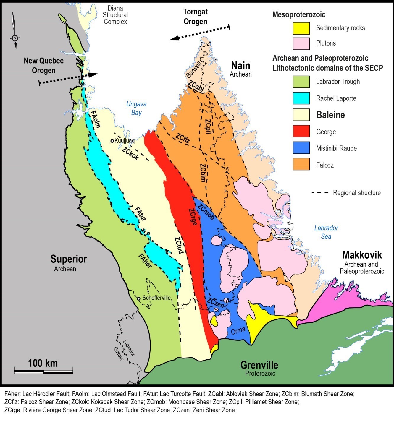
The Baleine Lithotectonic Domain, located in the west-central part of the Southeastern Churchill Province (SECP), is 615 km long by 15 to 100 km wide, for a total area of 36 365 km2. It is oriented generally NNW-SSE, except in the southern part where its orientation is more N-S. It is bordered to the east by the George Lithotectonic Domain, with which it is in fault contact in the southern part of the SECP (ZCtud). In the northern part, the contact is more arbitrarily defined and locally masked by the presence of large zones of late-tectonic intrusive rocks of the De Pas Granitic Suite. On the western side, the Baleine Domain is in contact with the Rachel-Laporte Domain through large relay faults, which are represented, from north to south, by the Lac Olmstead and Lac Turcotte faults. At its southern end, the Baleine Domain is in contact with the Labrador Trough through the Gill Lake Fault.
Geology
Rocks of the Baliene Domain have been grouped into different lithodemic units, mainly suites and complexes, according to the North American Stratigraphic Code (NACSN, 2005; MER, 1986; Easton, 2009) and taking into account the established nomenclature. These units were defined based on available geological and geochronological data. They are presented chronologically in the legend of the geological map by Lafrance et al (2020) and in the table below. Only lithologies of the main units are mentioned. References to ages cited in this record can be found in Lafrance et al. (2020) as well as in respective stratigraphic records of the different geological units.
The Baleine Lithotectonic Domain can be divided geographically into four sections according to lithological characteristics and structural styles of each section.
The central section is characterized by the presence of an extensive cover of Neoarchean metasedimentary rocks associated with the False Suite (<2678 Ma), which were affected by a major Paleoproterozoic partial melting event. This event resulted in the production of a large volume of diatexite and metatexite (Winnie Suite) with an estimated age of emplacement between 1838 Ma and 1807 Ma. The False and Winnie suites cover nearly 25% of the Baleine Domain. The central section of the Baleine Domain also includes Neoarchean potassic intrusive rocks of the Saffray Suite (2696-2683 Ma) associated with strong positive aeromagnetic anomalies of general E-W orientation.
Although it covers larger areas in the north, gneissic bedrock of the Baleine Domain (Ungava Complex) has been observed throughout the domain and represents >20% of its total area. These gneiss are migmatized to varying degrees, with the areas most affected by partial melting being assigned to the Qurlutuq Complex. The Aveneau Suite (1818-1811 Ma) is another unit of important surface area (~12%) observed throughout the entire Baleine Domain. It consists of white tonalite and granite containing schlierens interpreted as the end product of regional partial melting in the Paleoproterozoic (Simard et al., 2013).
The northern and southern sections of the Baleine Doamin are distinguished from the central section by the presence of a few particular units, the main ones being the Kaslac Complex (1835-1827 Ma) in the northern part, and the Knox Complex (2823-2619 Ma) and the Champdoré (1859-1837 Ma), Lhande (1834 Ma) and Grand Rosoy (<2618 Ma) suites in the southern part. The Grand Rosoy Suite, which represents a meta-arkose and meta-arenite sequence, is interstratified with paragneiss and amphibolite units of the Akiasirviup and Curot suites. These suites are concentrated at the western edge of the domain and outcrop mainly in the northern and southern sections, whereas they form only a thin strip in the central section.
The last section is associated with the Diana Structural Complex, an independent unit that represents the detached NW end of the Baleine Domain. This complex consists of a package of gneissic tonalite and stris of paragneiss, amphibolite and ultramafic rocks of Archean and Proterozoic age that was affected by intense deformation and metamorphism during the Paleoproterozoic. The various units included in the Diana Structural Complex could possibly be correlated with other units listed in the table below. However, divisions used by Madore and Larbi (2000) are different from those presented by Lafrance et al. (2020); field checks would be required to perform this correlation exercise.
| MESOPROTEROZOIC | ||
| mPhar | Harp Dykes | Ophitic and massive olivine gabbro |
| mPfal | Falcoz Swarm | Subophitic and massive olivine gabbro and olivine gabbronorite |
| mPsoi | Soisson Suite | Subophitic troctolite, olivine gabbro, gabbro and gabbronorite |
| PALEOPROTEROZOIC | ||
| pPdac | Dancelou Suite | Massive granite and pegmatitic granite |
| pPpot | Potel Gabbro | Massive gabbro and gabbronorite |
| pPavn | Aveneau Suite | Massive to foliated white tonalite and granite |
| pPkaa | Kaslac Complex | Deformed and metamorphosed mafic to felsic intrusive rocks |
| pPgin | Gamelin Enderbite | Massive enderbite |
| pPlnd | Lhande Suite | Intermediate to mafic intrusive rocks |
| pPtak | Tasialuk Suite | Porphyraceous granodiorite and tonalite |
| pPchu | Chaumaux Pluton | Massive and granoblastic anorthosite |
| pPchm | Champdoré Suite | Potassic felsic to intermediate intrusive rocks, variably recrystallized |
| pPkuu | Kuujjuaq Pluton | Foliated to gneissic tonalite and granodiorite |
| pPwii | Winnie Suite | Diatexite and metatexite derived from melting of paragneiss |
| De Pas Supersuite | ||
| pPcde | De Pas Charnockitic Suite | Variously porphyraceous opdalite, jotunite and mangerite |
| pPdep | De Pas Granitic Suite | Variously porphyraceous granodiorite and quartz monzodiorite |
| ARCHEAN AND PALEOPROTEROZOIC | ||
| nApPcut | Curot Suite | Amphibolite |
| ApPqur | Qurlutuq Complex | Banded migmatitic rocks |
| ApPral | Ralleau Suite | Amphibolitized mafic and ultramafic intrusive rocks |
| APdia | Diana Structural Complex | Gneissic tonalite, paragneiss, amphibolite and potassic intrusive rocks |
| ARCHEAN | ||
| nAfas | False Suite | Migmatized paragneiss |
| nAgy | Grand Rosoy Suite | Hematite-specularite meta-arkose and meta-arenite |
| nAaki | Akiasirviup Suite | Biotite-muscovite paragneiss and paraschist |
| nAsaf | Saffray Suite | Foliated and granoblastic quartz monzonite |
| nAgrf | Griffis Complex | Tonalite, tonalitic gneiss, paragneiss and mafic intrusive rocks |
| Agkx | Knox Complex | Felsic to intermediate gneiss and hypersthene gneiss |
| Aung | Ungava Complex | Tonalitic to granitic gneiss |
Geological Evolution
The geological history of the Baleine Domain begins in the Archean with the emplacement of most of the constituent stratigraphic units. The oldest units are the Ungava, Knox and Qurlutuq gneissic and migmatitic complexes, with crystallization ages ranging from 2843 Ma to 2619 Ma, as well as the Saffray Suite (2696-2683 Ma). These units are interpreted as representing the bedrock on which metasedimentary rocks of the Akiasirviup, False and Grand Rosoy suites were deposited (Lafrance et al., 2020). The significant age spread of gneissic complexes suggests that there may be several different units within them (Lafrance et al., 2020). Although gneiss ages are unevenly distributed across the Baleine Domain, available data suggest that gneiss bedrock is older in the northern part of the domain (Lafrance et al., 2020).
The stratigraphic diagram presented by Lafrance et al. (2020) illustrates initial relationships between Archean to Paleoproterozoic units and Paleoproterozoic to Mesoproterozoic intrusive rocks. Some aspects of the Baleine Domain’s evoulution during the Archean remain unclear. For example, it is generally accepted that this domain was attached to the Superior Craton (Perreault and Hynes, 1990; James and Dunning, 2000; Wardle et al., 2002; Lafrance et al., 2014; Rayner et al., 2017; Corrigan et al., 2018; Lafrance et al., 2020) prior to rifting of the Archean continent along its NE margin at ~2.2 Ga (Clark and Wares, 2004). The Baleine Domain would thus represent, along with the Rachel-Laporte Domain, one of the two constituents of the SECP to contain rocks that previously belonged to the Superior. This hypothesis is based on geochronological data and comparable compositions of certain units observed in the SECP and the Superior Province, as well as on the possible extension of large E-W magnetic anomalies on either side of the Labrador Trough (Lafrance et al., 2020). In addition, geochronological results indicate that Archean units underwent some degree of partial melting in the Archean ~2809 Ma (Augland et al., 2016). However, imprint of this tectometamorphic event was largely obliterated during emplacement of the New Quebec Orogen in the Paleoproterozoic (Moorhead, 1989; Poirier, 1989; Goulet, 1995). This is confirmed by numerous metamorphic ages (1864 Ma-1786 Ma) obtained in the Ungava Complex.
During edification of the New Quebec Orogen, upper amphibolite or granulite facies metamorphic conditions were reached at the scale of the domain (Poirier, 1989; Perreault and Hynes, 1990; Simard et al., 2013; Lafranceet al., 2014 and 2020; Charette et al., 2016; Godet et al., 2020), indicating burial under conditions of medium crustal conditions responsible for the formation of migmatites and plutonic masses. A significant portion of the material produced comes from partial melting of metasedimentary rocks and constitutes migmatites of the Winnie Suite. Gneiss of the Ungava Complex also underwent an anatexis process that is at the origin of part of the Aveneau Suite (Simard et al., 2014). Nevertheless, the origin of magma composing most of this suite remains ambiguous.
The metamorphic modeling and petrochronology work carried out in the central part of the Baleine Domain allowed Godet et al. (2020) to interpret three tectonic evolution phases associated with the New Quebec Orogen as follows: 1) during collision with the George Domain, the Baleine Domain was first buried and underwent metamorphism reaching the granulite facies; 2) thrusting of the Baleine Domain over the Rachel-Laporte Domain along the Lac Turcotte Fault led to isothermal decompression in the Baleine Domain, and burial of Rachel-Laporte Domain rocks and their metamorphism to the amphibolite facies; 3) juxtaposition of these two domains that were progressively exposed to their current level by erosion. This model implies that the Lac Turcotte Fault represents an important metamorphic discontinuity that is revealed by the metamorphic diachronism between the Baleine and Rachel-Laporte domains, rather than by a gradient observed in the field that would reveal a gradual increase in the intensity of metamorphism.
References
Publications Available Through SIGÉOM Examine
AUGLAND, L.E., DAVID, J., PILOTE, P., LECLERC, F., GOUTIER, J., HAMMOUCHE, H., LAFRANCE, I., TALLA TAKAM, F., DESCHÊNES, P.-L., GUEMACHE, M.A., 2016. Datations U-Pb dans les provinces de Churchill et du Supérieur effectuées au GEOTOP en 2012-2013. GEOTOP, MERN. RP 2015-01, 43 pages.
CHARETTE, B., LAFRANCE, I., VANIER, M.-A., 2016. Géologie de la région du lac Jeannin. MERN. BG 2015-01, 1 plan.
GOULET, N., 1995. Études structurales, stratigraphiques et géochronologiques de la partie nord de la Fosse du Labrador. MRN. MB 95-36, 41 pages, 1 plan.
HAMMOUCHE, H., LEGOUIX, C., GOUTIER, J., DION, C., PETRELLA, L., 2011. Géologie de la région du lac Bonaventure. MRNF. RG 2011-03, 37 pages, 1 plan.
LAFRANCE, I., VANIER, M.-A., CHARETTE, B., 2020. Domaine lithotectonique de Baleine, sud-est de la Province de Churchill, Nunavik, Québec, Canada : synthèse de la géologie. MERN. BG 2020-07, 2 plans.
LAFRANCE, I., CHARETTE, B., VANIER, M.-A., 2018. Sud-est de la Province de Churchill, Nunavik, Québec, Canada : synthèse de la géologie. MERN. BG 2018-12.
LAFRANCE, I., SIMARD, M., BANDYAYERA, D., 2014. Géologie de la région du lac Saffray (SNRC 24F, 24G). MRN. RG 2014-02, 51 pages, 1 plan.
MADORE, L., LARBI, Y., 2000. Géologie de la région de la rivière Arnaud (SNRC 25D) et des régions littorales adjacentes (SNRC 25C, 25E, 25F). MRN. RG 2000-05, 39 pages, 4 plans.
MER. 1986. CODE STRATIGRAPHIQUE NORD-AMERICAIN. DV 86-02, 76 pages.
SIMARD, M., LAFRANCE, I., HAMMOUCHE, H., LEGOUIX, C., 2013. Géologie de la région de Kuujjuaq et de la baie d’Ungava (SNRC 24J, 24K). MRN. RG 2013-04, 62 pages, 1 plan.
Autres publications
BARDOUX, M., DIGONNET, S., DONOHUE, L., GIRAD, B., ROBILLARD, M., DAVID, J., PARENT, M., GARIÉPY, C., 1998. Paleoproterozoic tectonics affecting Archean lower crust of southern Ungava Bay. In: Eastern Canadian Shield Onshore–Offshore Transect (ECSOOT), Report of the 1998 Transect Meeting (Wardle, R.J.,Hall, J., editors). University of British Columbia, Lithoprobe Secretariat; Lithoprobe Report 68, pages 1-17.
CORRIGAN, D., WODICKA, N., McFARLANE, C., LAFRANCE, I., VAN ROOYEN, D., BANDYAYERA, D., BILODEAU, C. 2018. Lithotectonic framework of the Core Zone, Southeastern Churchill Province. Geoscience Canada; volume 45, pages 1-24. doi.org/10.12789/geocanj.2018.45.128
EASTON, R.M., 2009. A guide to the application of lithostratigraphic terminology in Precambrian terrains. Stratigraphy; volume 6, pages 117-134.
GODET, A., GUILMETTE, C., LABROUSSE, L., DAVIS, D.W., VANIER, M.-A., LAFRANCE, I., CHARETTE, B. 2020. Contrasting P-T-t paths reveal a metamorphic discontinuity in the New Quebec Orogen: insights into Paleoproterozoic orogenic processes. Precambrian Research; article 105675. doi.org/10.1016/j.precamres.2020.105675
JAMES, D.T., DUNNING, G.R., 2000. U-Pb geochronological constraints for Paleoproterozoic evolution of the Core Zone, southeastern Churchill Province, northeastern Laurentia. Precambrian Research; volume 103, pages 31-54. dx.doi.org/10.1016/S0301-9268(00)00074-7
JAMES, D.T., CONNELLY, J.N., WASTENEYS, H.A., KILFOIL, G.J., 1996. Paleoproterozoic lithotectonic divisions of the southeastern Churchill Province, western Labrador. Canadian Journal of Earth Sciences; volume 33, pages 216-230. dx.doi.org/10.1139/e96-019
MOORHEAD, J., 1989. Stratigraphy, structure and metamorphism of the Renai basement gneiss body and the adjacent cover succession in the western hinterland zone of the northern Labrador Trough, west of Kuujjuaq, northern Quebec. McGill University; master thesis, 284 pages.
NORTH AMERICAN COMMISSION ON STRATIGRAPHIC NOMENCLATURE (NACSN), 2005. North American Stratigraphic Code. The American Association of Petroleum Geologist Bulletin; volume 89, pages 1547-1591. doi.org/10.1306/07050504129
PERREAULT, S., HYNES, A. 1990.Tectonic evolution of the Kuujjuaq terrane, New Québec Orogen. Geosciences Canada; volume 17, pages 238-240. journals.lib.unb.ca/index.php/GC/article/view/3695
POIRIER, G.G., 1989. Structure and metamorphism of the eastern boundary of the Labrador Trough near Kuujjuaq, Québec, and its tectonic implications. McGill University; master thesis, 174 pages.
POIRIER, G., PERREAULT, S., HYNES, A., 1990. Nature of the eastern boundary of the Labrador Trough near Kuujjuaq, Quebec. In The Early Proterozoic Trans-Hudson Orogen (Lewry, J.F., Stauffer, M.R,, editors). Geological Association of Canada; Special Paper 37, pages 397-412.
RAYNER, N.M., LAFRANCE, I., CORRIGAN, D., CHARETTE, B., 2017. New U-Pb zircon ages of plutonic rocks from the Jeannin Lake area, Quebec: an evaluation of the Kuujjuaq Domain and Rachel-Laporte Zone. Geological Survey of Canada; Current Research 2017-4, 14 pages. doi.org/10.4095/306180
VAN DER LEEDEN, J., BÉLANGER, M., DANIS, D., GIRARD, R., MARTELAIN, J., 1990. Lithotectonic domains in the high-grade terrain east of the Labrador Trough (Quebec). In The Early Proterozoic Trans-Hudson Orogen (Lewry, J.F., Stauffer, M.R,, editors). Geological Association of Canada; Special Paper 37, pages 371-386.
WARDLE, R.J., JAMES, D.T., SCOTT, D.J., HALL, J. 2002. The southeastern Churchill Province: synthesis of a Paleoproterozoic transpressional orogen. Canadian Journal of Earth Science; volume 39, pages 639-663. doi.org/10.1139/e02-004
WARDLE, R.J., RYAN, B., ERMANOVICS, I., 1990. The eastern Churchill Province, Torngat and New Québec orogens: An overview. Geoscience Canada; volume 17, pages 217-222.
Suggested Citation
Ministère de l’Énergie et des Ressources naturelles (MERN). Baleine Lithotectonic Domain. Quebec Stratigraphic Lexicon. https://gq.mines.gouv.qc.ca/lexique-stratigraphique/province-de-churchill/domaine-lithotectonique-de-baleine_en [accessed on Day Month Year].
Contributors
|
First publication |
Isabelle Lafrance, P. Geo., M.Sc. isabelle.lafrance@mern.gouv.qc.ca (redaction) Mehdi A. Guemache, P. Geo., Ph.D. (coordination); Claude Dion, Eng., M.Sc. (critical review); Simon Auclair, P. Geo., M.Sc. (editing); André Tremblay (HTML editing); Céline Dupuis, P. Geo., Ph.D. (English version). |