


Geology of the Commissaires Lake Area, Grenville Province, Saguenay–Lac-Saint-Jean Region, Quebec, Canada
Project for NTS sheets 32A01, 32A02, 32A07 and 32A08
Abdelali Moukhsil and Yannick Daoudene
BG 2019-01
Translated on 3 March 2020


A new geological map of the Commissaires Lake was produced at 1:50 000 scale following a survey conducted during the summer of 2018. It mainly consists of Mesoproterozoic stratigraphic units (0.99-1.52 Ga). These units form intrusive suites and complexes of felsic to intermediate rocks, metasedimentary rock complexes, oval or circular felsic to mafic intrusions, and lenticular mafic intrusions. In the NE corner of the map, sequences of Ordovician sedimentary rocks unconformably overlie Precambrian rocks.
An analysis of the area's structural domains reveals three deformation phases. The oldest, D2, affects most of the Mesoproterozoic units. It is distinguished by a tectonic foliation S2 developed in amphibolite and granulite facies metamorphic rocks. The next phase, D3, is expressed by regional folding of S2. P3 folds are kilometric in size, tight or isoclinal and oriented NNW-SSE. There is also an axial foliation S3. The last phase, D4, is only observed regionally. It also results in open or tight kilometric P4 folds oriented ENE-WSW. The sinistral strike-slip movement of the Saint-François-de-Sales Shear Zone (ZCsfs) appears to be contemporary to phase D4 and is associated with retrogressive metamorphic conditions.
The area has nine prospective zones for mineral exploration, grouped into four types of deposits: 1) Fe-Ti±P±V or Ni-Cu in mafic and ultramafic intrusive rocks of the Claire Gabbronorite, Rodez Plutonic Suite and Travers Suite; 2) rare earth elements in syenitic to granitic intrusions of the Travers Suite; 3) sillimanite and graphite in Wabash Complex paragneiss; and 4) magmatic Ni-Cu associated with a mafic intrusion of the Travers Suite.
Methodology
The area was mapped using the established method for surveys in forest areas served by a network of secondary roads. Geological mapping was conducted by a team of three geologists, two geologists-in-training, one engineer-in-training and seven students between June 1st and August 17, 2018.
The mapping and synthesis of the Commisssaires Lake project has produced and updated information presented in the table to the right:
| Element | Number |
|---|---|
| Described outcrop (“geofiche”) | 1993 outcrops |
| Total lithogeochemical analysis | 342 samples |
| Lithogeochemical analysis of metals of economic interest | 87 samples |
| Covered thin section | 253 |
| Polished thin section | 101 |
| Sodium cobaltinitrite stain | 0 |
| Stratigraphic unit | 24 |
| Mineralization record | 8 |
| Architectural, crushed or industrial stone record | 6 |
Previous Work
The table below lists the work that has been done in the Commissaires Lake area since 1918. It also includes references cited in the report.
| Author(s) | Type of Work | Contribution |
|---|---|---|
| Dresser, 1918 | Mapping of the Lake Saint-Jean region (southern portion) | First geological mapping of the southern Lake Saint-Jean region |
|
Mapping in the Roberval District at 1:63 000 scale Doctoral thesis |
Discovery and description of Fe-Ti mineralized zones Petrological study of Fe-Ti mineralization |
|
| Benoit and Valiquette, 1971 | Geological reconnaissance | Identification of several lithologies |
| Laurin and Sharma, 1975 | Mapping and geological reconnaissance at 1:250 000 scale | Multi-year mapping project (1965-1967) |
| Mapping and geological reconnaissance at 1:250 000 scale | Identification of several lithostratigraphic units and updating of known mineralized zones and areas for dressed stone. | |
| Intissar and Benahmed, 2015 | High-resolution aeromagnetic surveys | The region is entirely covered by aeromagnetic surveys. |
| Travaux géophysiques et étude de la zone minéralisée de Touladi | 3D model based on geophysical data for Fe-Ti mineralization |
Lithostratigraphy
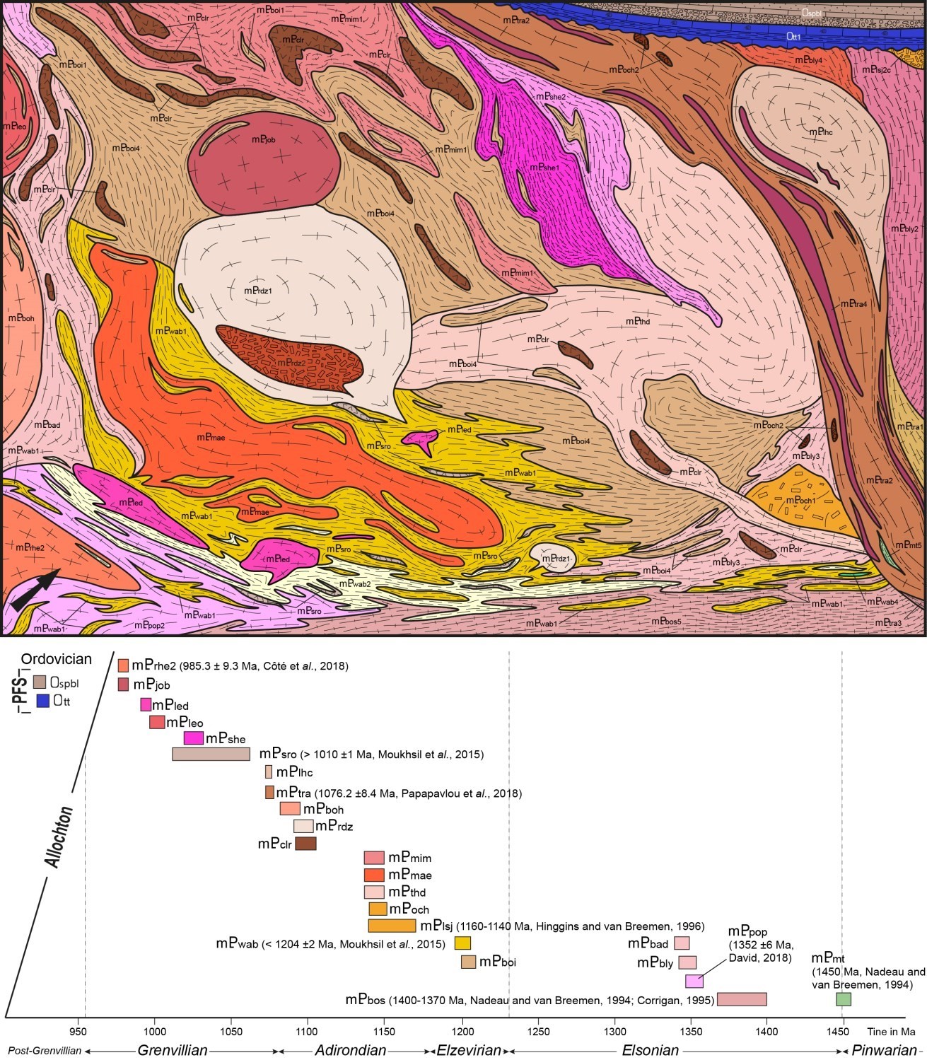
This section briefly presents the various units mapped in the Commissaires Lake area in a stratigraphic and temporal setting. The opposite stratigraphic diagram and chronological frieze accompany this discussion. The lithological description of units can be consulted from their respective stratigraphic records via the hyperlink associated with their name.
Mesoproterozoic Bedrock
With the exception of the Montauban Group (mPmt), the oldest stratigraphic units of the area are composed of mafic to intermediate intrusive rocks, commonly gneissic. It consists of the La Bostonnais Complex (mPbos) and the Pope (mPpop), Belley (mPbly) and Bardeau (mPbad) plutonic suites. La Bostonnais Complex rocks range in age from 1.4 to 1.37 Ga (Nadeau and van Breemen, 1994; Corrigan, 1995). At the same time, a granitic gneiss from the Pope Plutonic Suite gave a preliminary age of 1352.7 ±6 Ma (U-Pb on zircons) (David, 2018). However, there is currently no dating to indicate the age of the Belley and Bardeau plutonic suites.
The Wabash (mPwab) and Barrois (mPboi) complexes overlie these four intrusive rock packages. These units are located north and south of the Commissaires Lake area, respectively. They consist mainly of metasedimentary rocks with varying amount of mobilisate. The Wabash Complex has a maximum deposit age of ~1204 Ma (Moukhsil et al., 2015). The Wabash Complex was introduced into the Parent area by Moukhsil et al. (2015) and extended into Clova and Wemotaci areas (Moukhsil et al., 2016; Moukhsil and Côté, 2017). The Barrois Complex was defined by Morfin et al. (2015) in the Lake Saint-Jean area. In the Commissaires Lake area, where complexes are juxtaposed, our petrochemical observations do not distinguish between metasedimentary rocks of either of these units.
In the Commissaires Lake area, the Travers Suite (mPtra) overlaps with a large regional shear zone called the Saint-François-de-Sales Shear Zone (ZCsfs). This suite stands out for its great diversity of intrusive rocks from mafic to felsic composition. A U-Pb zircon age of 1076.2 ±8.4 Ma from a syenogranite (Papapavlou et al., in preparation) suggests that the Travers Suite was emplaced during early Grenvillian. Nevertheless, its rock diversity does not preclude the possible presence of older packages. In the mapped area, a kilometric lens of mafic volcanic rocks, trapped in the Travers Suite, has been assigned to the Montauban Group (mPmt). This group is dated at ~1.45 Ga (Nadeau and van Breemen, 1994) and is the oldest unit in the area.
Mesoproterozoic Intrusions
The above packages of intrusive and sedimentary rocks (mPbos, mPpop, mPbly, mPbad, mPboi and mPwab) host kilometric intrusions composed primarily of felsic to intermediate rocks. Some intrusions, such as the Thaddé (mPthd), Marianne (mPmae) and Mimosa (mPmim) plutonic suites, show lithological and structural characteristics that could indicate a fairly old emplacement, perhaps contemporaneous to the Lac-Saint-Jean (mPlsj) (1160-1140 Ma, Higgins and van Breemen, 1996) and Ouiatchouan (mPoch) anorthositic suites.
Other more surface-rounded and less deformed intrusions, such as the Rodez (mPrdz), Bonhomme (mPboh) and Léo (mPleo) plutonic suites, Lachance (mPlhc) and Jobber (mPjob) mangerites, and Sainte-Hedwidge (mPshe) and Leda (mPled) intrusive suites, appear to be younger. The age range of these intrusions is indicative of an emplacement corresponding to the Adirondian and Grenvillian orogens. The Rhéaume Intrusive Suite is the youngest Precambrian unit in the mapped area and intrudes into the Pope Plutonic Suite.
The Claire Gabbronorite and Roc Suite could be the source of old regional systems of mainly mafic sills or dykes. In maps, they consist of kilometric lenticular masses hosted in paragneiss units or moderately to highly deformed intrusive rocks. This distribution of the Claire Gabbronorite and Roc Suite would be the result of dyke dismemberment following regional polyphase deformation (see below).
Ordovician Sedimentary Cover
Northeast of the mapped area, St. Lawrence Platform sedimentary rock sequences unconformably (angular discordance) overlie Mesoproterozoic units. Ordovician sedimentary rocks belong to the Trenton Group (Ott) and Pointe Bleue Formation (Ospbl).
Lithogeochemistry
La lithogeochemistry of units in the Commissaires Lake area is presented separately in tabular form.
Structural Geology
Based on structural criteria, the Commissaires Lake area was subdivided into seven domains. These include the Bouchette, Commissaires, Lac-Saint-Jean, Ministic, Saint-André-du-Lac-Saint-Jean and Sainte-Hedwidge structural domains, as well as the Saint-François-de-Sales Shear Zone. With the exception of the Lac-Saint-Jean Structural Domain, which consists only of undeformed Ordovician sedimentary rock sequences, all domains include only Mesoproterozoic stratigraphic units.
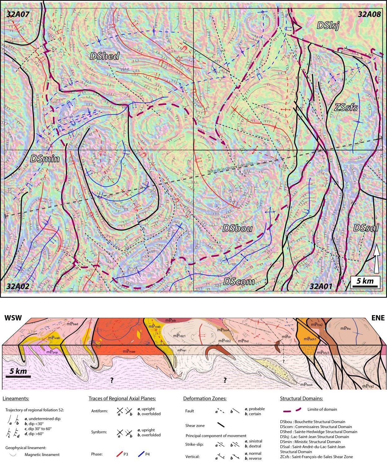
A structural analysis of these domains suggests that the mapped area has been affected by at least three phases of deformation in the Mesoproterozoic. In the event that fabrics are assigned to a deformation phase prior to those discussed here, the phase identified as the oldest is called D2. Subsequent deformation phases are referred to as D3 and D4, from oldest to most recent. However, the main deformation phase of a structural domain does not necessarily correspond to that of the neighbouring domain. For this reason, the main deformation phase of a structural domain or shear zone is, by convention, designated Dn in records of the structural lexicon. Earlier phases are called Dn-1, Dn-2 and so on, whereas later ones are called Dn+1, Dn+2, etc. In the study area, structures associated with the Dn phase of the Saint-François-de-Sales Shear Zone are younger than those of neighbouring Precambrian structural domains. Thus, in order to clarify the description that follows, it was decided to match the Dn phase of the Bouchette, Commissaires, Lac-Saint-Jean, Ministic, Saint-André-du-Lac-Saint-Jean and Sainte-Hedwidge structural domains to D2, and the Dn phase of the Saint-François-de-Sales Shear Zone to D4. In addition, the orientation of axial plane traces involves linking the Dn+1 phase of the Commissaires Structural Domain to D4, whereas the Dn+1 phase of the other domains is rather associated with D3. The remainder of this section provides a chronological description of these deformation phases. The opposite map and structural section are used to illustrate the text.
Boundaries between domains correspond mainly to changes in the general attitude of the main foliation (usually S2) and the orientation of regional axial plane traces. Zones with greater deformation than the surroundings mark local boundaries. However, they are discontinuous and poorly documented. As such, their particularities and origins are not discussed in this bulletin.
Deformation Phase D2
The D2 deformation phase is visible at the outcrop scale. It affects all stratigraphic units emplaced before ~1.2 Ga. The D2 deformation is therefore particularly well expressed in the Barrois and Wabash metasedimentary complexes, as well as in the La Bostonnais Complex and in the Pope, Belley and Bardeau plutonic suites. The D2 deformation also affected intrusive units such as the Thaddé, Marianne, Mimosa and Rodez plutonic suites.
This deformation phase is expressed by a tectonic foliation S2, developed under high-temperature metamorphic conditions. This foliation consists of migmatitic banding, gneissosity or simply a diffuse foliation highlighted by the preferential orientation of ferromagnesian minerals such as hornblende or pyroxenes. Its attitude varies greatly from one domain to another or within a domain. For example, in the Ministic Structural Domain, the S2 foliation is often oriented NE-SW, whereas in the Commissaires Domain it is oriented ENE-WSW. In the Bouchette and Sainte-Hedwidge structural domains, the S2 foliation is rather oriented NW-SE to N-S. However, its map representation, particularly its trajectory drawn from field measurements and geophysical lineaments derived from high-resolution magnetic-field maps (Intissar and Benahmed, 2015), shows the presence of numerous folds of various styles and orientation. In any event, at the scale of the Commissaires Lake area, the S2 foliation generally dips towards the east, NE or SE when it is oriented N-S, NW-SE and NE-SW respectively.
The S2 fabric regularly carries a more or less intense mineral or stretching lineation L2. Its attitude varies greatly regionally, likely due to polyphase folding of the foliation that carries it. Nevertheless, statistical analysis of measurements in the different structural domains shows that the L2 lineation plunge is often at a high angle to the carrier plane azimuth direction.
Deformation Phase D3
The D3 folding phase mainly affects the Ministic, Bouchette and Sainte-Hedwidge structural domains. It is distinguished by axial plane traces more or less N-S oriented, highlighting tight or isoclinal folds with wavelength and amplitude up to several tens of kilometres.
A very diffuse S3 axial plane foliation at the outcrop scale is generally observed in P3 fold hinge areas. It is highlighted by the preferential orientation of biotite flakes, as well as the more or less pronounced flattening of quartz grains in the most deformed quartzofeldspathic rocks. Outside of P3 fold hinge areas, S2 and S3 foliations are almost always confused. For this reason, it is generally difficult to distinguish the two fabrics in the field, hence the limited number of S3 planes measured. However, the common east dip of the S2-S3 composite fabric indicates that, at the domain scale, several P3 folds are overturned westward (see section).
A L3 stretching lineation, usually with low plunges, was commonly measured on S3 planes or S2-S3 composite planes, as in the case of the Bouchette Structural Domain.
Deformation Phase D4
The D4 deformation phase is recognized in all structural domains located west of the Saint-François-de-Sales Shear Zone. However, no planar or linear fabrics associated with this deformation phase were recognized in the field. Despite this, this deformation phase is regionally discernible by folding of P3 axial plane traces. P4 folds are tight to open and, outside of large intrusive masses, have a wavelength of a few kilometres and amplitude of up to several tens of kilometres. Axial planes show a fairly regular orientation in the ENE-WSW direction.
The presence of NE-SW folds along the Saint-François-de-Sales Shear Zone, oriented N-S, suggests that the structure's sinistral strike-slip movement is contemporaneous to the D4 deformation phase.
Metamorphism
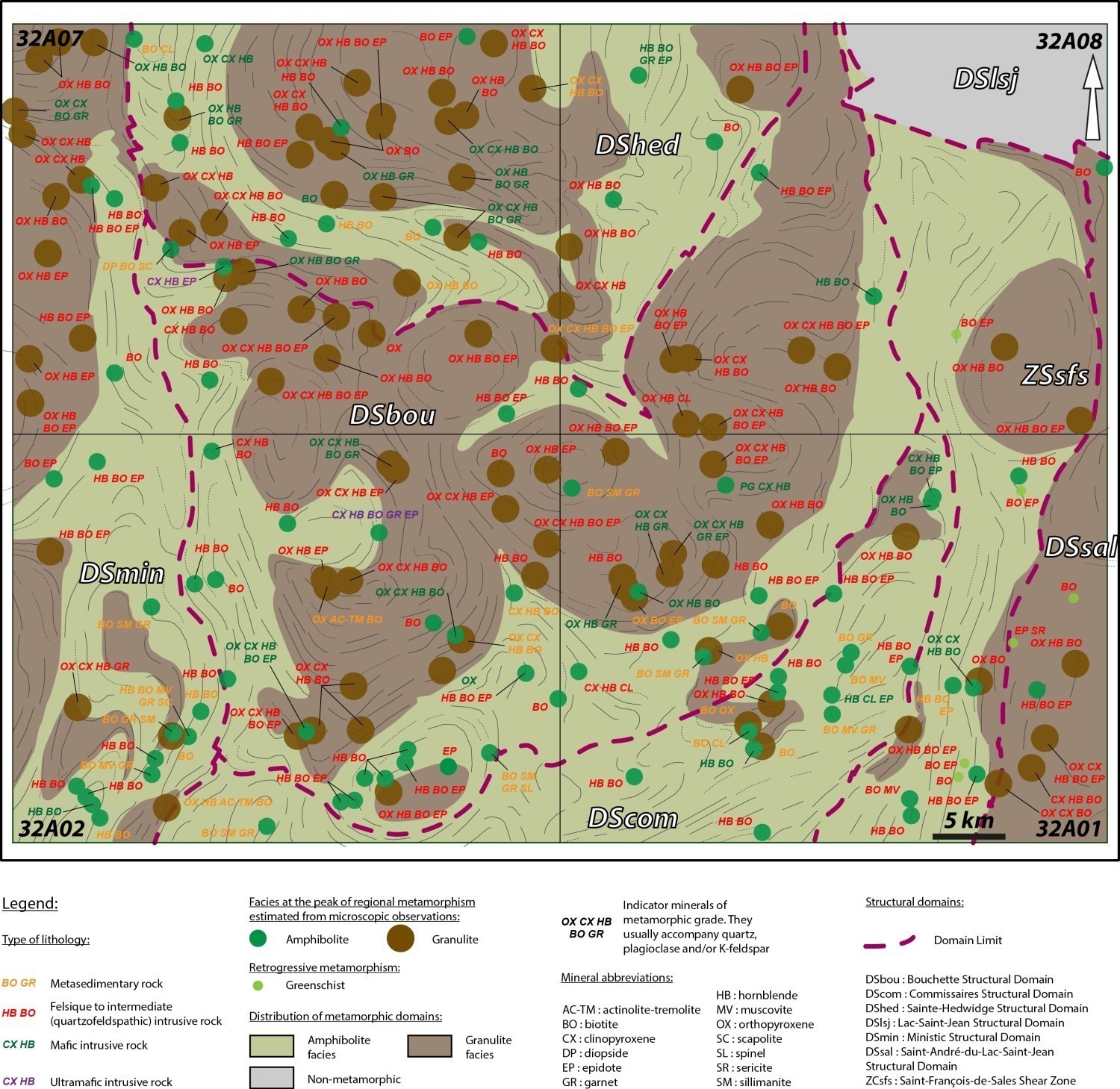
The opposite metamorphic map is the result of the compilation of polarizing microscope observations from 189 representative Mesoproterozoic unit samples. It shows that virtually all samples are characterized by high-temperature metamorphic conditions, and that these conditions vary within a structural domain.
High-Temperature regional Metamorphism
In domed areas, such as those where intrusive rocks of the Marianne, Rodez, Mimosa, Bonhomme and Léo plutonic suites are found, mineralogical assemblages are generally quartz-feldspar-biotite-orthopyroxene ±clinopyroxene ±hornblende ±garnet. Assemblages are diagnostic of the granulite metamorphic facies. In addition, deformed quartzofeldspathic rocks show high-temperature textures. They are medium to coarse grained and grain edges are usually rounded, both indicating a dynamic recrystallization process through grain joint movement. Quartz grains with chessboard textures are also very common and show a deformation temperature of ≥600°C (Blumenfeld et al., 1986; Gapais and Barbarin, 1986). Other bowl-shaped intrusions, such as the Leda Intrusive Suite and the Lachance Mangerite, recorded granulite facies metamorphic conditions.
Apart from the sectors discussed above, the available information does not support the conclusion that regional metamorphism has reached the granulite facies. Felsic to intermediate intrusive rocks preferentially show quartz-feldspar-biotite-hornblende ±epidote mineralogical assemblages without pyroxene. At the same time, metasedimentary rocks of the Wabash Complex locally have a biotite-sillimanite-garnet assemblage typical of upper amphibolite facies metamorphic conditions.
At the scale of the Commissaires Lake area, metamorphic facies distribution is roughly modelled on the S2 foliation trajectory, suggesting that regional metamorphism is contemporaneous to the D2 deformation phase. This interpretation is also based on the fact that the S2 foliation is regularly marked by a high-temperature fabric, such as migmatitic banding commonly observed in the Barrois and Wabash complexes.
Retrogressive Shear Deformation
The most deformed rock samples from the Saint-François-de-Sales Shear Zone show textures indicating retrogressive metamorphic conditions. For example, mylonitized quartzofeldspathic rocks of Travers Suite contain core and mantle type feldspar porphyroclasts. At the edge of porphyroclasts, quartz dynamic recrystallization is dominated by sub-grain rotation. Such textures indicate deformation temperatures between 400°C and 500°C (Passchier and Trouw, 2005), thus at the lower amphibolite facies.
In places, syndeformation metamorphic conditions indicate a lower grade since feldspar porphyroclasts are intensely fractured. Some fractures also cut the quartzofeldspathic matrix. In addition, decimetric to metric strips of highly chloritized and hematitized cataclastic rocks are commonly observed along the entire length of the Saint-François-de-Sales Shear Zone. Their presence confirms the retrogressive nature of deformation at the greenschist facies, even at lower temperature conditions.
Economic Geology
Nine (9) prospective zones for mineral exploration have been identified in the area. They are divided in four types of deposits:
- Magmatic Fe-Ti (±P±V) mineralization associated with mafic and ultramafic intrusive rocks;
- Rare earth mineralization associated with syenitic intrusions of the Travers Suite;
- Industrial minerals such as sillimanite and graphite in metasedimentary rocks of the Wabash Complex;
- Magmatic Ni-Cu mineralization associated with a mafic intrusion.
The table of mineralized zones below presents analytical results for the six (6) known mineralized zones in the area, as well as those that have been discovered as part of this mapping work.
| Name | Content |
|---|---|
| Magmatic Ni-Cu mineralization associated with mafic-ultramafic rocks | |
| Regard perdu | Metre-thick ultramafic dyke containing ~15% disseminated millimetric sulphide grains: pne sample (G) provided 171 ppm Co; 1050 ppm Cu; 154 000 ppm Fe; 1390 ppm Ni; 21 800 ppm Ti. |
| Zirconium mineralization | |
| 18-JG-6274 | Gabbronorite containing nearly 5% oxides (magnetite). One sample (G) provided 3900 ppm Zr, 17.7% Fe, 10 ppm Mo, 78.4 ppm Y and 314 ppm Zn. |
| Sillimanite mineralization | |
| L'Ours | The rock contains ~10% sillimanite, 10% lilac-pink garnet porphyroblasts and 10% biotite; traces of pyrrhotite and graphite may also be observed. |
| Lionel | Aluminous metasomatic alteration is visible throughout the paragneiss. It is expressed by an overabundance of garnet (as high as 30-40% locally), as well as sillimanite, whose concentration reaches 20% in places. Sillimanite occurs as small, prismatic, millimetric, honey-coloured rods. The sulfuric odour released by paragneiss in fresh exposure also indicates the presence of sulphides. Also, there is graphite in small quantities. |
| Architectural stone | |
| Mimosa | K-feldspar-plagioclase porphyritic whitish mangerite in altered surface and grey-green in fresh exposure. In thin section, K-feldspar is perthitic and mangerite contains orthopyroxene, biotite, hornblende, magnetite, myrmekite within feldspar, and accessory minerals such as zircon, titanite, apatite and some opaques (pyrite). |
| Name | Contents |
|---|---|
| Mineralization associated with granitic pegmatites | |
| Rivière Trenche Est | 1000 ppm Th (G) |
| Fe-Ti mineralization in mafic intrusions | |
| Lac Touladi | 46% Fe (A); 13% Ti (A) |
| Projet EP | 481 500 ppm Fe (G); 21 800 ppm P (G); 144 700 ppm Ti (G); 1800 ppm V (G) |
| Lac Hondorat | Disseminated magnetite and ilmenite reaching 20% in gabbronorite; 300 000 ppm Fe (G) |
| Undetermined type of mineralization | |
| Kennedy | 35 900 ppm Mo (G) |
| Lac des Commissaires |
2.72 ppm Ag over 1.7 m (D); 790 ppb Au over 1.7 m (D); 33 ppm Mo (G); 4000 ppm Pb (G); 3820 ppm Zn (G) Other analyses of mineralized samples (G): 4800 ppm Mo, 3810 ppm Zn, 1440 ppm Pb, 362 ppm Cu and 2.5 ppm Ag |
| Mine du lac Bouchette | Contents: 99.80% SiO2, 0.06% Al2O3 and 0.03% Fe2O3 (mean analysis of purified quartz; Maurice 1966). Stringer quartz is milky white, massive and of great purity. It often contains small geodes filled with quartz crystals and is found in places with slight reddish colours due to traces of hematite. Most quartz is milky, but slightly pinkish. Cavities, which rarely exceed 5 cm, are lined with clear to milky quartz crystals, some of which reach 2 cm. Quartz is covered with finely granular hematite spots and dark brown earthy goethite. Quartz crystals cannot be classified as gems. |
| Silice de Chambord | Contents: 99.2-98.5% SiO2 (G). QE-1: 0.22% Al2O3, 0.17% CaO, 0.008% TiO2 and 0.39% FeO; QE-2: 0.30% Al2O3, 0.48% CaO, 0.20% TiO2 and 0.44% FeO and QE-3: 0.57% Al2O3, 0.45% CaO, 0.27% TiO2 and 0.43% FeO. Silica contents of Girard (1996; GM 54554) were obtained by subtracting major elements (Al2O3, CaO, TiO2 and FeO) of the total analysis. |
| Architectural stone | |
| Lac de la Bête | |
| Carrière Vert Printemps | |
| Carrière Marcelin Néron | |
| Lac Mirage | |
(D): Diamond drilling; (G): Selected sample; (A): Combination of several values.
The table of lithogeochemical analyses of metals of economic interest provides the location, description, and analytical results for eighty-seven (87) samples selected to assess the economic potential of the area.
Prospective Zones for Fe-Ti±P±V Mineralization Associated with the Claire Gabbronorite, Rodez Plutonic Suite and Travers Suite

Several mafic and ultramafic intrusions prospective for magmatic Fe-Ti oxides mineralization have been recognized in the study area. They are divided into three areas, from NW to SE: the Touladi, Rodez and Hondorat prospective zones. The latter are associated with different stratigraphic units.
In sheet 32A07, the Touladi prospective zone groups kilometric bodies of the Claire Gabbronorite intruding along the eastern edge of the Mimosa Plutonic Suite. The Lac Touladi mineralized zone shows a local anorthositic metagabbro in which centimetre-thick bands or lenses are rich in disseminated or massive magnetite, ilmenite and hemo-ilmenite. These bands are concentrated in several hectometric zones. Samples from different outcrops gave contents reaching 46% Fe and 13% Ti (Grenier, 1959; Boulianne, 2003; Boily, 2010, 2014).
In the centre of the mapped area, the Rodez prospective zone is the most mafic unit of the Rodez Plutonic Suite, composed mainly of gabbronorite, leuconorite and anorthosite, porphyritic to megacristic and little or not deformed. The Ep Project zone, revealed by exploration work (Girard, 2017), has strips or metric clusters of ultramafic rocks, heavily enriched in magnetite and hemo-ilmenite (>50%) and apatite (15%). A Ministère's analysis provided showing contents of 41.4% Fe, 24.14% Ti and 0.17% V and an anomalous content of 4.99% P2O5. More recently, other samples collected around this zone gave showing values up to 45.46% Fe, 12.3% Ti and 0.18% V (Girard, 2017; Pelletier, 2017). These results suggest that other Fe-Ti-P-V mineralized zones may be discovered in the area. Note that a sample of gabbronorite containing nearly 5% oxides provided showing content of 0.39% Zr and a significantly high content of 17.7% Fe.
In the SE corner of sheet 32A01, the Hondorat prospective zone is associated with large volumes of gabbronorite related to mangerites and syenites of the Travers Suite. Gabbronorite contains between 5 and 20% Fe-Ti oxides. In the 1960s, the Lac Hondorat mineralized zone was discovered in this area as a result of geological work (Benoit and Valiquette, 1971); up to 20% magnetite-ilmenite disseminated in gabbronorite was described. However, the exact location of this mineralization could not be identified. A gabbronorite sample, taken near the mineralized zone, nevertheless provided anomalous contents of 9.94% Fe, 1.4% Ti and 289 ppm V. Another sample collected ~2 km north of this mineralization has anomalous values of 10.4% Fe, 1.13% Ti and 331 ppm V.
Based on the relative abundance of gabbronorite in the area, future exploration could lead to the discovery of new mineralized zones.
Prospective Zones for Rare Earth Mineralization Associated with Syenitic Intrusions of the Travers Suite
The Travers Suite mostly consists of gabbronorite and mangerite. However, it displays syenite locally, especially south of the Lachance Mangerite in sheet 32A01. These intrusions are generally small and elongated parallel to the average structural grain oriented N-S.
The small Des sectionnaires prospective zone is located in the south portion of sheet 32A01. It is superimposed on a relatively homogeneous medium-grained greyish syenite. This syenite does not seem particularly deformed. It contains orthopyroxene, hornblende and magnetite. One sample gave an anomalous rare earth content of 1145 ppm.
North of sheet 32A08, the Équerre prospective zone is superimposed on a N-S elongated syenite intrusion and thereby on a positive magnetic susceptibility anomaly. In outcrop, syenite is pink, medium grained and little or not deformed. A sample gave an anomalous rare earth content of 1048.79 ppm.
Although no mineralized zone has been discovered to date, rare earth anomalies highlight the economic potential of the Travers Suite syenites.
Prospective Zones for Industrial Minerals Such as Sillimanite and Graphite in Metasedimentary Rocks of the Wabash Complex

The mapped area has a large proportion of paragneiss, some of which are very aluminous. The combined action of high-temperature metamorphism and early hydrothermal alteration locally produced high levels of sillimanite. Three prospective zones for the exploration of this industrial mineral have been identified and are described below.
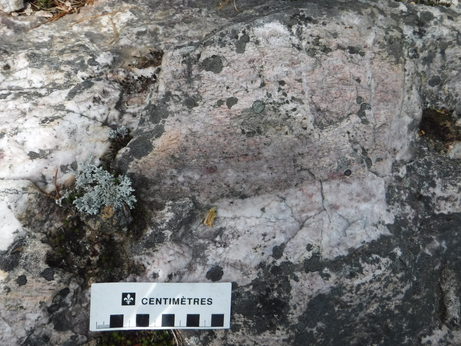
On the NW side of sheet 32A01, the small Lionel prospective zone shows a migmatitized paragneiss of the Wabash Complex (18-YD-2043) forming a decametric to hectometric lens in the Rodez Plutonic Suite. Aluminous metasomatic alteration is visible throughout the paragneiss. It is expressed by an overabundance of garnet and sillimanite (small honey-coloured millimetre prisms) with concentrations reaching 40% and 20% of the total rock, respectively. A paragneiss sample analysis returned 10.7% Al2O3.
The Ours prospective zone, in the centre of sheet 32A01, is a kilometre-wide area where paragneiss of the Wabash Complex outcrops. Concentrations of up to 10% sillimanite, 10% garnet and 10% biotite were estimated. Traces of pyrrhotite and graphite may also be observed. Sillimanite occurs in clusters of submillimetric acicular fibres. A sample analysis gave 16.2% Al.
In the SW portion of sheet 32A02, the large Rivière Trenche prospective zone includes Wabash Complex units running along the Pope Plutonic Suite to the east. Here, metasedimentary rocks can contain up to 10% graphite and 15% sillimanite locally. Graphite occurs in millimetric, blackish and greasy clusters or disseminated in metallic grey flakes. Less abundant sillimanite occurs in both honey-coloured euhedral millimetre prisms and whitish clusters of submillimetre fibers.
Prospective Zones for Magmatic Ni-Cu Mineralization Associated with a Mafic Intrusion of the Travers Suite

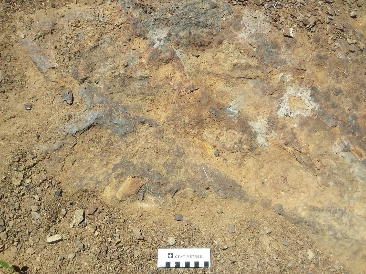
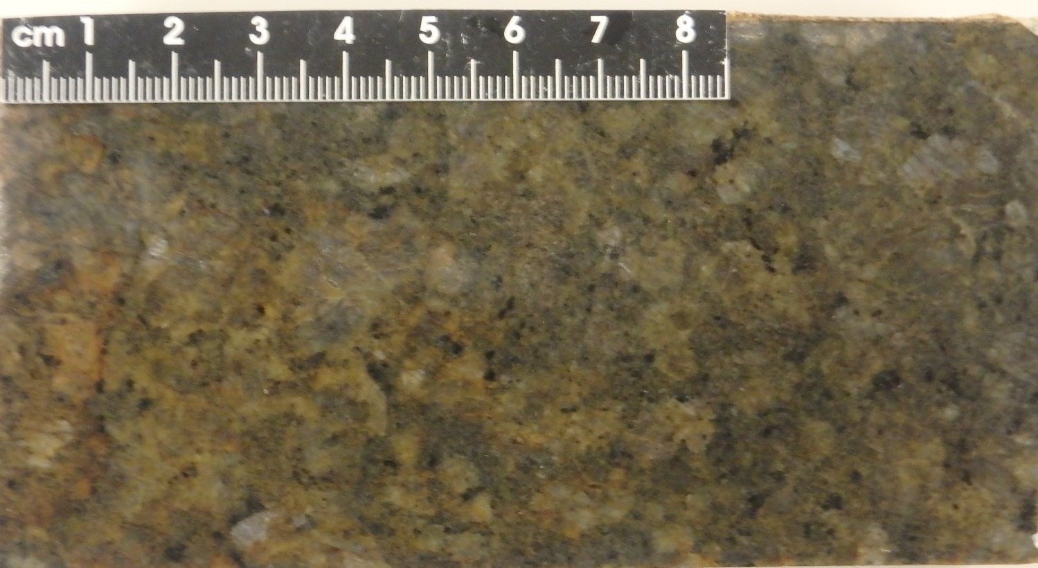
Located in the eastern part of sheet 32A01, the small Du Curé prospective zone has potential for magmatic Ni-Cu-type mineralization. It includes a highly rusted gabbronorite outcrop (18-YD-2099) of decametric extension cut by an anastomosed network of millimetric fractures partially filled with sulphides. These fractures show two main directions: 048° and 103°. In less fractured zones, gabbronorite contains <1% disseminated sulphides (pyrite and pyrrhotite) in millimetric and subhedral grain clusters. Some clusters show more or less regular zoning where pyrrhotite grains are bordered by pyrite and chalcopyrite. Pyrrhotite fractures are filled with chalcopyrite.
Other Mineralized Zones of Interest
In addition to the nine prospective zones described above, the mapped area is of interest for other mineral substances.
In sheet 32A01, the Lac des Commissaires mineralized zone was discovered in 1962 on an amphibolite outcrop of the Wabash Complex containing traces of copper, nickel, iron and molybdenum (Benoît and Valiquette, 1971). As early as 1978, several reconnaissance and drilling activities were carried out around the site. Small mineralized veins intercepted in two drills yielded contents of up to 0.79 g/t Au and 2.72 g/t Ag over 1.7 m (Parent and Gaucher, 1981). Surface mineralized samples gave up to 4800 ppm Mo, 3810 ppm Zn, 1440 ppm Pb, 362 ppm Cu and 2.5 ppm Ag (Landry, 1983).
Near the Chambord station (sheet 32A08), molybdenum mineralization of the Kennedy zone was discovered in 1915. This mineralization is located in a metric pegmatite dyke at a short distance from contact with gneissic host rock of the Travers Suite. Molybdenite was estimated at 6% (Claims Kennedy, 1953).
The Rivière Trenche Est mineralized zone, in sheet 32A07, has thorite-rich pegmatite dykes intruding gabbro (Bray, 1960) of the Bardeau Plutonic Suite. An analyzed sample returned over 0.1% Th.
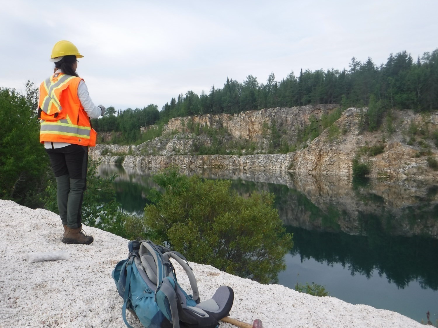
The mapped area has a quartz quarry and mineralized zone, called Mine du lac Bouchette and Silice de Chambord respectively. These are two hectometric quartz veins, located respectively to the west and northeast of the Lachance Mangerite, in the eastern portion of sheet 32A08. The Mine du lac Bouchette quartz contains 99.8% SiO2 (Maurice, 1966) and operated from 1932 to 1974, producing 62 000 t of silica metal (Lavergne, 1985). The Silice de Chambord site has never been exploited, but SiO2 contents range between 98.5 and 99.2% (Girard, 1996).
The area is known for its potential for dressed stone (Lac de la Bête, Carrière Vert Printemps, Carrière Marcelin Néron, Lac Mirage). A new site was identified during mapping work: the Mimosa site consists of a syenite of the Mimosa Plutonic Suite that outcrops in several areas accessible by forest roads. At this site, the rock is less fractured, but further study is needed to determine stone quality and usable volume.
Discussion and conclusion
The new 1:50 000 scale geological map significantly improves the stratigraphic, structural and metallogenic descriptions of the Commissaires Lake area, SE of the Lake Saint-Jean. However, many questions remain unanswered, the most important of which concern regional stratigraphy and structural geology.
From a stratigraphic perspective, relationships between intrusive rock complexes known to be older than 1.3 Ga have yet to be resolved. Given the limited geochronological information available, there is no reason to exclude that some of these units belong to the same package (see stratigraphic diagram). Also, the distribution of the Wabash and Barrois complexes follows the logic of previous geological surveys; however, our petrochemical observations currently do not differentiate between the two units. The hypothesis that sedimentary rocks of these complexes have a common origin cannot therefore be ruled out. Finally, the Travers Suite contains a variety of lithologies that lead to questions about the usefulness of this unity.
At the working scale, some issues could not be resolved given the structural complexity of some entities. The Marianne Plutonic Suite shows, for example, a magnetic pattern and a S2 foliation trajectory suggesting more than two folding phases. The detailed structural study of such units would provide further information on the deformation phases that shaped the Grenvillian bedrock in the area. Similarly, a more successful structural characterization of the Saint-François-de-Sales Shear Zone, which shows deformation acquired in a retrogressive metamorphic context, would provide additional information on the latest phases of the Grenvillian deformation.
The planned geological surveys of the BCGQ to the north, in the areas of Saint-Félicien and Dolbeau-Mistassini, should nevertheless allow us to complete the knowledge obtained as a result of our work. They may even provide answers to some of the questions above. At the same time, pending geochronological analyses of a number of representative samples of units in the Commissaires Lake area will undoubtedly help refine the regional stratigraphy.
| Authors |
Abdelali Moukhsil, P.Geo., Ph.D. Abdelali.Moukhsil@mern.gouv.qc.ca Yannick Daoudene, P.Geo., Ph.D. Yannick.Daoudene@mern.gouv.qc.ca |
| Geochemistry | Fabien Solgadi, P.Geo., Ph.D. |
| Geophysics | Siham Benahmed, P.Geo.-in-training., M.Sc. Rachid Intissar, P.Geo., M.Sc. |
| Potential assessment | Hanafi Hammouche, P.Geo., M.Sc. |
| Geomatics | Karine Allard Kathleen O'Brien |
| Template and content compliance | François Leclerc, P.Geo., Ph.D. |
| Coaching/mentoring and critical review |
Fabien Solgadi, P.Geo., Ph.D. |
| English version | Céline Dupuis, P.Geo., Ph.D. |
| Organism | General direction of Géologie Québec, Ministère de l'Énergie et des Ressources naturelles, Government of Quebec |
Acknowledgements:
This Geological Bulletin was made possible through the cooperation of many people who have been actively involved in the various stages of the project. We would like to thank engineer Marc-Antoine Vanier, geologist-in-training Marc-André Pelletier, geologists Christopher Lambert and Francis Talla Takam, students Émilie Charbonneau, Philippe Delobel, Christophe Ménard, AnnaTo, as well as technician Alexandre Lacasse. Not to mention the super-juniors Jocelyn Gremmel and Antoine Prost, who provided excellent work. Discussions with Kostas Papapavlou (geochronologist), Christian Dupuis (geophysicist, Université Laval) and Rachid Intissar were very beneficial. We are very grateful to Karine Allard for her strong contribution to our geological maps. We are also grateful to all the Hermitage Saint-Antoine staff for the excellent service provided throughout the summer. Helicopter transport in the field was provided by Héli-Inter, which performed their work efficiently and professionally.
References
Publications Available through Sigéom Examine
BENOIT, F W., VALIQUETTE, G. 1971. REGION DU LAC SAINT-JEAN (PARTIE SUD). MRN. RG 140, 29 pages and 5 plans.
BOILY, M. 2010. TECHNICAL REPORT AND RECOMMENDATIONS, THE LAKE TOULADI FE-TI DEPOSIT. CLAIMS YACOUB. Assessment work submitted to the Government of Québec. GM 66891, 84 pages.
BOILY, M. 2014. TECHNICAL REPORT AND RECOMMENDATIONS, THE TOULADI LAKE FE-TI DEPOSIT. CLAIMS YACOUB. Assessment work submitted to the Government of Québec. GM 68439, 90 pages.
BOILY, M. 2015. STANDARD MAGNETIC INVERSION (SMI), MAGNETIC VECTOR INVERSION (MVI), PROBABILITY OF REMANENCE (PR) AND 3D MODELING OF HELI-BORNE MAGNETIC SURVEY DATA, LAKE TOULADI PROPERTY. CLAIMS YACOUB. Assessment work submitted to the Government of Québec. GM 69743, 30 pages and 1 plan.
BOULIANNE, D. 2003. RAPPORT DES TRAVAUX DE 2002-2003, PROJET TITANE 2002. CLAIMS BRASSARD, LES RESSOURCES D'ARIANNE INC, CLAIMS LECUYER. Assessment work submitted to the Government of Québec. GM 60442, 105 pages.
BRAY, J.G. 1959. RAPPORT PRELIMINAIRE SUR LA REGION DE LYONNE, DISTRICT ELECTORAL DE ROBERVAL. MRN. RP 387, 12 pages and 1 plan.
BRAY, J G. 1960. LA LIEVRE AREA (COMTE DE ROBERVAL). MRN. DP 463, 78 pages and 1 plan.
CLAIMS KENNEDY. 1953. KENNEDY MOLYBDENITE PROSPECT. Assessment work submitted to the Government of Québec. GM 11530, 1 page.
DAVID, J., 2018. Datations U-Pb dans les provinces de Grenville et du Supérieur effectuées au GEOTOP en 2016-2017. MERN, GEOTOP; MB 2018-17, 22 pages.
GIRARD, P A. 2017. Projet EP, phosphore, vanadium, titane apatite. CLAIMS PELLETIER. Assessment work submitted to the Government of Québec. GM 70490, 59 pages.
GIRARD, R. 1996. RAPPORT SOMMAIRE SUR LA GEOLOGIE, L'INDICE DE SILICE DE CHAMBORD. CLAIMS GIRARD, CLAIMS BARRETTE. Assessment work submitted to the Government of Québec. GM 54554, 14 pages and 3 plans.
GRENIER, P E. 1959. RAPPORT D'INFORMATION. ROBERVAL MINING CORP. Assessment work submitted to the Government of Québec. GM 08373, 4 pages.
INTISSAR, R., BENAHMED, S. 2015. LEVE MAGNETIQUE AEROPORTE DANS LE SECTEUR OUEST DU LAC-ST-JEAN, PROVINCE DE GRENVILLE. MERN, GOLDAK AIRBORNE SURVEYS. DP 2015-06, 7 pages and 2 plans.
LANDRY, R. 1983. CERTIFICATS D'ANALYSES. CLAIMS LANDRY. Assessment work submitted to the Government of Québec. GM 40592, 15 pages.
LAURIN, A.F., SHARMA, K.N.M. 1975. REGION DES RIVIERES MISTASSINI, PERIBONCA, SAGUENAY, (GRENVILLE 1965-1967). MRN. RG 161, 103 pages and 10 plans.
LAVERGNE, C. 1985. GITES MINERAUX A TONNAGE EVALUEE ET PRODUCTION MINERALE DU QUEBEC. MRN. DV 85-08, 85 pages.
MAURICE, O D. 1966. MEMORANDUM SUR DES DEPOTS DE SILICE DANS LA GEION DE CHICOUTIMI ET SAGUENAY. QUEBEC SILICA MINE LTD, LEEDS METALS CO LTD. Assessment work submitted to the Government of Québec. GM 17710, 2 pages.
MORFIN, S., TREMBLAY, C., SOLGADI, F., MOUKHSIL, A., DAIGNEAULT, R., 2015. GEOLOGIE DE LA REGION DE CHAMBORD, ROBERVAL ET NOTRE-DAME-DE-LA-DORE (FEUILLETS SNRC 32A08, A09 ET A10) ET RECONNAISSANCE DES FEUILLETS 32A06, A07 ET A11. MERN, CERM; MB 2015-07, 69 pages, 5 maps.
MOUKHSIL, A., COTE, G. 2017. GEOLOGIE DE LA REGION DE WEMOTACI, HAUT-SAINT-MAURICE (PARTIE OUEST DU GRENVILLE). MERN. RG 2017-03, 44 pages and 2 plans.
MOUKHSIL, A., SOLGADI, F., BELKACIM, S. 2016. GEOLOGIE DE LA REGION DE CLOVA, HAUT-SAINT-MAURICE (PARTIE OUEST DU GRENVILLE). MERN, URSTM-UQAT. RG 2016-03, 52 pages and 1 plan.
MOUKHSIL, A., SOLGADI, F., BELKACIM, S., AUGLAND, L E., DAVID, J. 2015. GEOLOGIE DE LA REGION DE PARENT, HAUT-SAINT-MAURICE (PARTIE OUEST DU GRENVILLE). MERN, UQAT-URSTM, GEOTOP-UQAM-MCGILL. RG 2015-04, 62 pages and 1 plan.
PAPAPAVLOU, K., MOUKHSIL, A., COTE, G., POIRIER, A., 2018. U-Pb Geochronology of Zircon by LA-ICPMS in samples from the Grenville Province (La Tuque Area, Quebec). GEOTOP, MERN; MB 2018-35, 23 pages.
PARENT, L., GAUCHER, E. 1981. CAMPAGNE DE FORAGES, JUILLET 80 - FEVRIER 81, LAC DES COMMISSAIRES. CLAIMS LANDRY. Assessment work submitted to the Government of Québec. GM 37914, 51 pages and 1 plan.
PELLETIER, E. 2017. Rapport de travaux d'exploration simplifié, projet EP. CLAIMS PELLETIER. Assessment work submitted to the Government of Québec. GM 70583, 31 pages.
Other Publications
BLUMENFELD, P., MAINPRICE, D., BOUCHEZ, J.L., 1986. C-slip in quartz from subsolidus deformed granite. Tectonophysics; volume 127, pages 97–115. doi:10.1016/0040-1951(86)90081-8.
BRAY, J.V., 1961. The petrology of La Lievre Area Roberval County, Quebec. McGill university; Ph.D. thesis, 157 pages. Source.
CÔTÉ, G., MOUKHSIL, A.,CONSTANTIN, M.,DAVID, J. 2018. Geochemical Characterization, Geochronology, and Geodynamic Implications of Grenville Rare Earths Bearing Syenites, Haut-Saint-Maurice, QC, Canada. Minerals, volume 8, 18 pages; doi:10.3390/min8080336.
CORRIGAN, D., 1995. Mesoproterozoic evolution of the south-central Grenville orogen: structural, metamorphic and geochronologic constraints from the Mauricie transect. Carleton University, Ph.D. Thesis, 282 pages.
DRESSER, J.A., 1918. Étude d'une partie de la région du Lac-Saint-Jean, Québec. Geological Survey of Canada; Memoir no. 92, 104 pages. doi:10.4095/119952.
GAPAIS, D., BARBARIN, B., 1986. Quartz fabric transition in cooling syntectonic granite (Hermitage massif, France). Tectonophysics; volume 125, pages 14. doi:10.1016/0040-1951(86)90171.
HIGGINS, M.D., VAN BREEMEN, O., 1996. Three generations of AMCG magmatism, contact metamorphism and tectonism in the Saguenay–Lac St. Jean region, Grenville Province, Canada, Precambrian Research; volume 79, pages 327–346.doi.org/10.1016/0301-9268(95)00102-6.
NADEAU, L., VAN BREEMEN, O., 1994. Do the 1,45-1,39 Ga Montauban Group and La Bostonnais Complex constitute a Grenvillian accreted terrane? In Program with Abstract. Geological Association of Canada/Mineralogical Association of Canada; volume 19, page A81.
PASSCHIER, C.W., TROUW, R.A.J., 2005. Microtectonics, 2nd Edition. Springer, New York. doi.org/10.1007/3-540-29359-0.
MOUKHSIL, A., DAOUDENE, Y., 2019. Geology of the Commissaires Lake Area, Grenville Province, Saguenay–Lac-Saint-Jean Region, Quebec, Canada. MRNF; BG 2019-01, 2 plans.