

Last modification:
| Author(s) | Moukhsil and Daoudene, 2019 |
| Methodology | Defined from geological survey |
| Geological(s) subdivision(s) | Grenville Province / Allochton |
| Main movement | Does not apply |
| Deformation style | Heterogeneous |
| Metamorphic facies (mean facies related to main deformation) | Granulites |
Background and Methodology
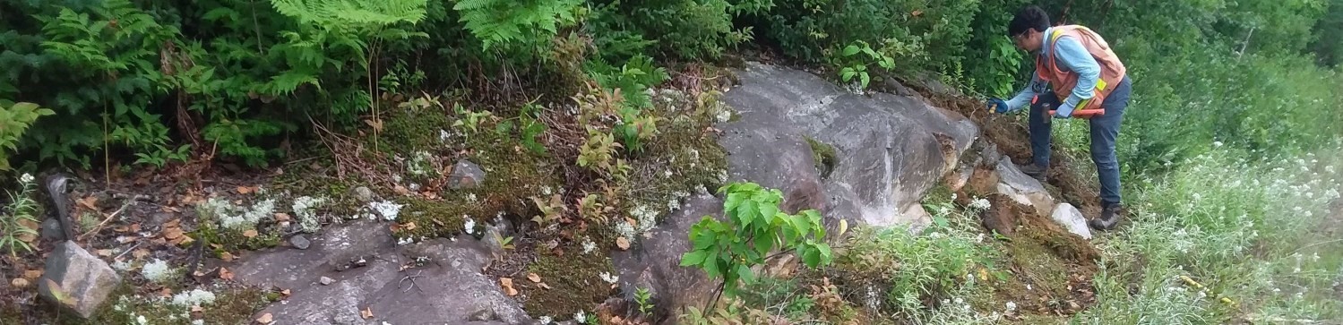
The Saint-André-du-Lac-Saint-Jean Structural Domain was defined following a geological mapping survey conducted by Moukhsil and Daoudene (2019) in the Commissaires Lake area (NTS sheets 32A01, 32A02, 32A07 and 32A08), SW of Lake Saint-Jean.
Boundaries and Morphology
| Width | Minimum of 560 m (sheet 32A08); maximum of 9 km (sheet 32A01) |
| Length | Minimum of 46 km (sheets 32A01 and 32A08) |
| Orientation | N-S elongation in sheets 32A01 and 32A08 |
The morphology and extent of the Saint-André-du-Lac-Saint-Jean Structural Domain are undetermined, as the domain was only documented in sheets 2A01 and 32A08, and mapped by Morfin et al. (2015) and Moukhsil and Daoudene (2019). In these sheets, the domain shows a N-S elongation of ~46 km and an E-W width ranging between 560 m and 9 km. However, most of the domain appears to be located in sheet 22D04, to the east of the Commissaires Lake area. The Saint-André-du-Lac-Saint-Jean Structural Domain also appears to be continuing southward in sheet 31P16. To the west, it is bounded by the Saint-François-de-Sales Shear Zone, while to the north it is masked by Ordovician sedimentary units of the Lac-Saint-Jean Structural Domain.
Stratigraphic Units Concerned
In sheets 32A01 and 32A08, the stratigraphic units present in the Saint-André-du-Lac-Saint-Jean Structural Domain are:
– Montauban Group (mPmt2);
– La Bostonnais Complex (mPbos4);
– Belley Plutonic Suite (mPbly2);
– Lac-Saint-Jean Anorthositic Suite (mPlsj2c);
– Travers Suite (mPtra1, mPtra2 and mPtra4).
Structural Characteristics
In sheets 32A01 and 32A08, most outcrops of the Saint-André-du-Lac-Saint-Jean Structural Domain show only one planar structural fabric, that is a very diffuse tectonometamorphic foliation. For this reason, and since the trajectory of foliation measurements appears to be roughly continuous from one outcrop to another, almost all measurements are attributed to Sn. It is also assumed that the associated Dn deformation phase is Grenvillian, i.e. aged between ~1.085 Ga and 0.986 Ga. Since the Grenvillian orogenic phase is the most recent of those recorded throughout the Grenville Province (i.e. see Moukhsil and Solgadi, 2018), planar structural fabrics associated with at least one earlier orogenic phase (Dn-1) could be identified later in the Saint-André-du-Lac-Saint-Jean Structural Domain. This is why it was chosen to match the Sn foliation to S2 in “geofiches” (not S1).
❯ Main Fabrics
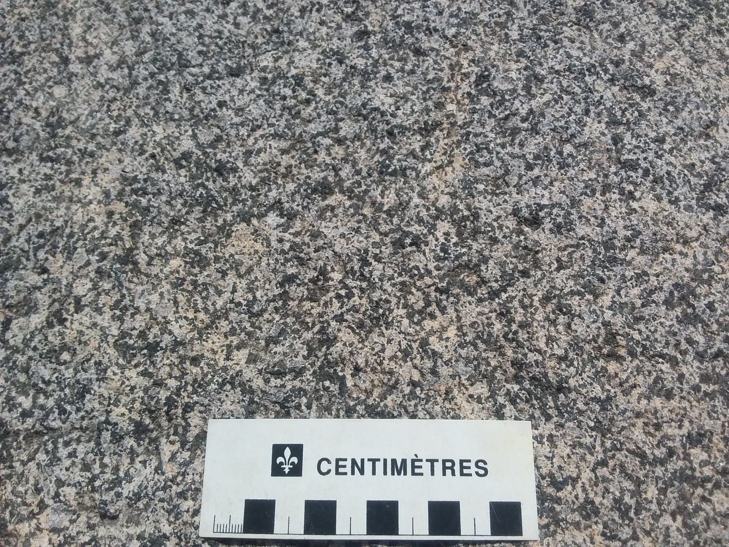
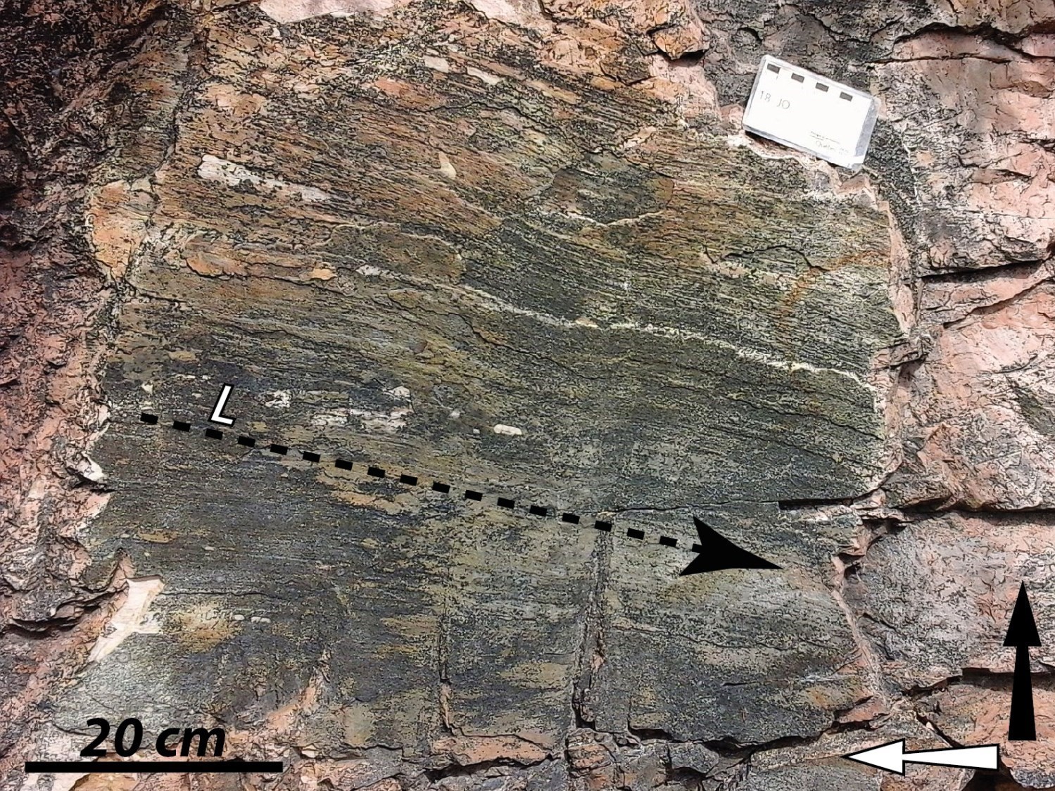
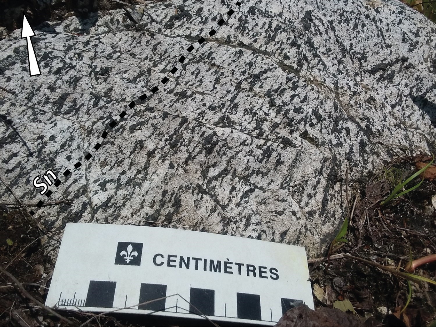 The deformation in the Saint-André-du-Lac-Saint-Jean Structural Domain is very heterogeneous, and the intensity varies greatly from one outcrop to another. Indeed, over a distance of a few hundred metres, some outcrops show intrusive rocks with little or no deformation, while others show the same rocks this time affected by a penetrative Sn foliation moderately to highly developed. Whether it is observed in outcrop or thin section, the Sn foliation is mainly highlighted by the preferential orientation of ferromagnesian mineral clusters (pyroxene, amphibole and biotite), and to a lesser extent by the flattening of quartz and feldspar grains.
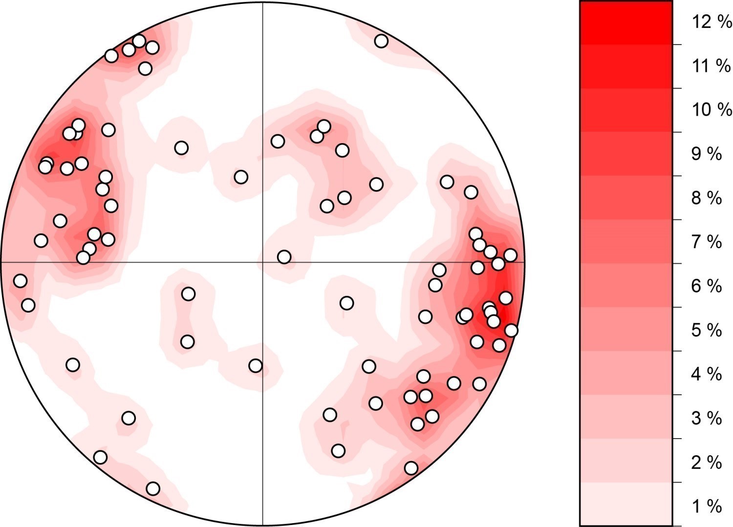
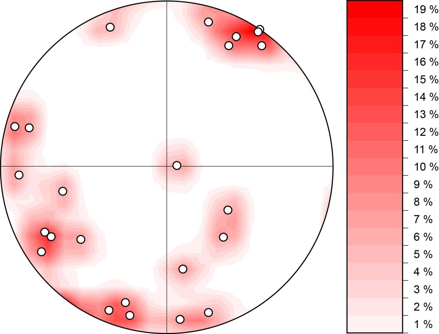
Therefore, only the area located in sheets 32A01 and 32A08 was the subject of a structural study. The analysis of Sn foliation measurements collected in this area alone does not define the trend at the domain scale. In any case, the Sn foliation is generally oriented NNE-SSW, in addition to having dips of varying intensity, but generally >60°. Two groups stand out on the stereographic projection of Sn foliation measurements: the first consists of foliation measurements having dips towards the WNW, while the second is characterized by dips towards the ESE. It seems that the first group is the most common.
| Main Fabric | Type of Fabric | Direction (°) | Dip (°) | Number of Measurements | Comments |
| Foliation Sn | Secondary tectonometamorphic mineral foliation, gneissosity, mylonitic foliation or banding | NNE-SSW | - | 75 | Two main groups: one with a mean dip ~80° towards the ESE, and the other with a similar average dip, but towards the WNW. |
| Lineation Ln | Mineral lineation, stretch lineation | - | - | 24 |
Measured lineations show very high variability, whether in terms of orientation or dip. |
❯ Other Fabrics

Rocks of the Saint-André-du-Lac-Saint-Jean Structural Domain are locally affected by shear bands commonly discontinuous, the width of which ranges from centimetric to metric. To date, only a few of them have been measured following the mapping survey of Moukhsil and Daoudene (2019), mainly in sheet 32A01. The intensity of deformation generally varies from band to band, but is often marked by a C/S structure and the presence of centimetric bands of mylonite and ultramylonite. Of the ten or so shear bands measured, most are N-S to NW-SE oriented and have moderate to steep dip. The associated stretch lineation is in many cases oriented at a low angle to shear bands' azimuth, suggesting that the associated kinematics have a predominantly strike-slip component. In all cases where the shear direction could be determined, the strike-slip component is always sinistral. Characteristics of these shear bands suggest that these structures are potentially related to those that are ubiquitous in the structural domain immediately to the west, namely the Saint-François-de-Sales Shear Zone.
❯ Folds
Not observed.
❯ Crosscutting Relationships

In sheet 32A01, the Saint-André-du-Lac-Saint-Jean Structural Domain is cut by the Métabetchouane Shear Zone, which was originally documented by Moukhsil and Côté (2018) in sheet 31P16. This NNE-SSW oriented shear zone is at least 30 km long and ~300 m wide. As it approaches the shear zone, the Sn foliation intensifies. In the Métabetchouane Shear Zone, foliation becomes mylonitic. This foliation carries mineral and stretch lineations whose plunge is generally shallow (8-12°) towards the NE. Kinematic criteria that can be regularly observed along this shear zone clearly indicate a main dextral component, a feature initially observed by Moukhsil and Côté (2018).
Geometric Parameters of Regional Faults Cutting the Saint-André-du-Lac-Saint-Jean Structural Domain:
| Fault or Family of Faults | Type | Mean Direction (°) | Mean Dip (°) | Lineation Plunge in the Fault Plane | Estimated Width (m) | Estimated Length (km) | Apparent Movement | Position | Comments |
| Métabetchouane Shear Zone | Regional shear zone | NNE-SSW | ~90 | 8-12 towards the NE | 300 | minimum 30 | Dextral | Certain | Observed in sheets 31P16 and 32A01 |
| Family of NW-SE faults | Regional fault | NW-SE | ~90 | - | - | 5-7.5 | Dextral | Interpetation based on geophysical surveys | Interpreted SE of sheet 32A01 and east of sheet 32A08 |
❯ Kinematics
Does not apply.
Deformation Style
Most of the Saint-André-du-Lac-Saint-Jean Structural Domain appears to be located in sheets 22D04 and 22D05. In this area, geology is still unknown and high-resolution magnetic field imaging is non-existent. Under these conditions, it seems difficult to discuss the possible style of deformation at the domain scale. Structural data from the mapping survey of Moukhsil and Daoudene (2019) nevertheless show that deformation is very heterogeneous in the Saint-André-du-Lac-Saint-Jean Structural Domain.
Metamorphic Characteristics
Thin section observation of about ten samples suggests that, in sheet 32A01, all units of the Saint-André-du-lac-Lac-Saint-Jean Structural Domain were affected by metamorphic conditions that have reached the granulite facies. Intermediate rocks of the Belley Plutonic Suite and Travers Suite commonly show plagioclase-quartz-feldspar-orthopyroxene-clinopyroxene-hornblende-biotite mineralogical assemblages. These quartzofeldspathic rocks usually marked by diffuse foliation have quartz and feldspar grains with usually very rounded contacts. This characteristic suggests a process of high-temperature dynamic recrystallization by grain border migration (Gower and Simpson, 1992). In addition, quartz grains usually show a chessboard texture. The latter indicates combined intracrystalline slippage along crystallographic directions a and c, and is indicative of grain deformation under temperature conditions ≥600°C (Blumenfeld et al., 1986; Gapais and Barbarin, 1986).
Alterations
Does not apply.
Geophysical Characteristics
In sheets 32A01 and 32A08, the magnetic signal of the Saint-André-du-Lac-Saint-Jean Structural Domain appears to be very heterogeneous. In this area, while the central part of the domain shows a smooth and very intense susceptibility zone on magnetic field maps (Intissar and Benahmed, 2015), it is much weaker in the areas immediately north and south, and its texture appears more shagreen.
Chronological Markers
NE of sheet 32A08, the Saint-André-du-Lac-Saint-Jean Structural Domain is unconformably overlain by Ordovician sedimentary units of the Trenton Group.
References
Publications available through Sigéom Examine
INTISSAR, R., BENAHMED, S. 2015. LEVE MAGNETIQUE AEROPORTE DANS LE SECTEUR OUEST DU LAC-ST-JEAN, PROVINCE DE GRENVILLE. MERN, GOLDAK AIRBORNE SURVEYS. DP 2015-06, 7 pages and 2 plans.
MORFIN, S., TREMBLAY, C., SOLGADI, F., MOUKHSIL, A., DAIGNEAULT, R. 2015. GEOLOGIE DE LA REGION DE CHAMBORD, ROBERVAL ET NOTRE-DAME-DE-LA-DORE (FEUILLETS SNRC 32A08, A09 ET A10) ET RECONNAISSANCE DES FEUILLETS 32A06, A07 ET A11. MERN, CERM. MB 2015-07, 69 pages and 5 plans.
MOUKHSIL, A., CÔTÉ, G. 2018. Géologie de la région du lac Borgia, Province de Grenville, nord de La Tuque, régions de la Mauricie et du Saguenay – Lac-Saint-Jean, Québec, Canada. Ministère de l’Énergie et des Ressources naturelles, Québec. BG 2018-01.
MOUKHSIL, A., DAOUDENE, Y. 2019. Géologie de la région du lac des Commissaires, Province de Grenville, région du Saguenay–Lac-Saint-Jean, Québec, Canada. Ministère de l’Énergie et des Ressources naturelles, Québec. BG 2019-01.
MOUKHSIL, A., SOLGADI, F. 2018. Géologie, potentiel minéral et cadre géodynamique des roches de la région du réservoir Daniel-Johnson (Manicouagan), partie centrale de la Province de Grenville. In MOUKHSIL, A., SOLGADI, F., JANNIN, S., GERVAIS, F., CROWLEY, J.L., AUGLAND, L.E., INDARES, A., LETOURNEAU, M., DUNNING, G., CLARK, T., GOBEIL, A., OHNENSTETTER, D., LAMOTHE, D., INTISSAR, R., BENAHMED, S., GROULIER, P.A. GEOLOGIE, POTENTIEL MINERAL ET CADRE GEODYNAMIQUE DES ROCHES DE LA REGION DU RESERVOIR DANIEL-JOHNSON (MANICOUAGAN), PARTIE CENTRALE DE LA PROVINCE DE GRENVILLE. MRN. MM 2017-01
Other publications
BLUMENFELD, P., MAINPRICE, D., BOUCHEZ, J.L. 1986. C-slip in quartz from subsolidus deformed granite. Tectonophysics; volume 127, pages 97–115. doi:10.116/0040-1951(86)90081-8.
GAPAI, D., BARBARIN, B. 1986. Quartz fabric transition in cooling syntectonic granite (Hermitage massif, France). Tectonophysics; volume 125, pages 357–370. doi:10.1016/0040-1951(86)90171.
GOWER, R.J.W., SIMPSON, C. 1992. Phase boundary mobility in naturally deformed, high-grade quartzofeldspathic rocks: evidence for diffusional creep. Journal of Structural Geology; volume 14, pages 301–313. doi:10.1016/0191-8141(92)90088-E.