


Geology of the Cadieux Lake Area, Opatica and Opinaca Subprovinces, Eeyou Istchee James Bay, Quebec, Canada
Project for NTS sheets 33A02, 33A07 and NE corner of NTS sheet 33A03
Anne-Marie Beauchamp
BG 2019-02
Published 17 December 2020 (original French version)
Translated 3 March 2021


A new preliminary geological map of the Cadieux Lake area (NTS sheets 33A02, 33A07 and northern part of sheet 33A03) was produced following a survey conducted in the summer of 2018. Mapping helped clarify the boundary between the Opatica and Opinaca subprovinces and led to a lithological and structural revision of the western branch of the Upper Eastmain Greenstone Belt (UEGB). The basal unit of the Dolent Formation is overlain, in fault contact, by polymictic conglomerates of the Bohier Group. The polarities measured in pillow basalts indicate an overturned sequence. The western end of the UEGB culminates in the closure of a regional anticlinal that plunges towards the NE. Metasedimentary rocks of the Laguiche Complex, which represent the bulk of Opinaca rocks, are separated into two tectonometamorphic domains by a large dextral strike-slip corridor. The NW part of the map exposes highly migmatized sedimentary rocks having formed at a deeper structural level than those south of the sheared corridor.
Fieldwork identified several prospective geological environments from a metallogenic perspective. Volcanic rocks and ultramafic sills of the Dolent Formation contain orogenic quartz veins and stratiform exhalative horizons. The contact zone between the MacLeod Batholith and paragneiss of the Laguiche Complex is a first-order metallotect for Cu-Mo-Ag-Au-W mineralization. Finally, spodumene was observed in pegmatite of the Wahemen Suite.
Methodology
The area was mapped using the established methodology for surveys conducted in remote areas without road access. Geological mapping work was conducted by a team of seven geologists and seven students between June 2 and August 24, 2018. Geological mapping and synthesis of the Lac Cadieux area has produced and updated information presented in the opposite table:
| Element | Number |
|---|---|
| Outcrop described (“geofiche”) | 1087 outcrops |
| Total lithogeochemical analysis | 322 samples |
| Lithogeochemical analysis of metals of economic interest | 44 samples |
| Geochronological analysis | 9 samples |
| Covered thin section | 361 |
| Polished thin section | 25 |
| Sodium cobaltinitrite stain | 206 |
| Stratigraphic unit | 9 |
| Mineralization record | 15 |
Previous Work
The table below provides a list of work completed in the study area since 1976. It also includes the references cited in the report.
| Author(s) | Type of Work | Contribution |
|---|---|---|
| Hocq, 1976 | Geological survey of the Ministère des richesses naturelles du Québec | Geology of the Cadieux lake area (sheets 33A01, 33A02, 33A07, 33A08, 33A09 and 33A10) |
| Hocq, 1985 | Geological synthesis of the Ministère des richesses naturelles du Québec | Geology of the Campan and Cadieux lakes area (eastern part of sheets 33A and 33H) |
| Geological synthesis of the Ministère des richesses naturelles du Québec | Geology of the Upper Eastmain Greenstone Belt (sheets 33A07 and 33A08) | |
| Detailed geological and magnetic surveys | Exploration work in the Upper Eastmain Greenstone Belt (UEGB) | |
| Geological surveys and prospecting |
Exploration in the area of the Macleod Batholith and Windy Mountain mineralized zone |
|
| Geological surveys and drilling work | Exploration work in the area of Cu-Mo-Ag-Au mineralized zones: Macleod, Macleod NE, ML-06-123, ML-06-128, Pointe Richard, Pointe Rocky and Windy-Cible 4-3 | |
|
Cook et al., 2008; Winter, 2011 |
Reports 43-101 | Summary of exploration work (mapping, prospecting and drilling) in the Macleod area |
| D'Amours, 2011 | Synthesis of James Bay aeromagnetic surveys | Complete coverage of the study area by aeromagnetic surveys |
| Aeromagnetic surveys | Detailed geophysical maps of the UEGB | |
| Solgadi, 2017 | Geochemical surveys (lake bottom anomalies) | Geochemical anomaly map (MERN) |
| Beauchamp et al., 2018 | Bulletin géologiQUE | Geology and Mineral Potential of the Bohier Island Area (sheets 33A01, 33A08 and western part of sheets 23D04 and 23D05) |
Lithostratigraphy
The area mapped covers sheets 33A07 and 33A02 as well as the SW part of sheet 33A03. It is located in the Superior Province, at the contact between the Opatica and Opinaca subprovinces. The relative chronology of the emplacement of these units is illustrated in stratigraphic diagrams that take into account crosscutting relationships described in the field and available U-Pb geochronological data. These diagrams are highly idealized geological sections of the study area illustrating the relationships between units as well as their relative positions.
Opatica Subprovince
The base of the regional stratigraphy, which corresponds to Mesoarchean to Neoarchean bedrock, consists of rocks of the Misasque Complex (Amiq), the Digne Pluton (mAdig) and possibly the Chiyaaskw Pluton (nAchw), which is located further east of the studied area. The Maingault Complex (nAmng), which outcrops on a thin strip in the southern part of the map, could also be a package of rocks related to the Opinaca Subprovince and underlying the Opinaca Basin.
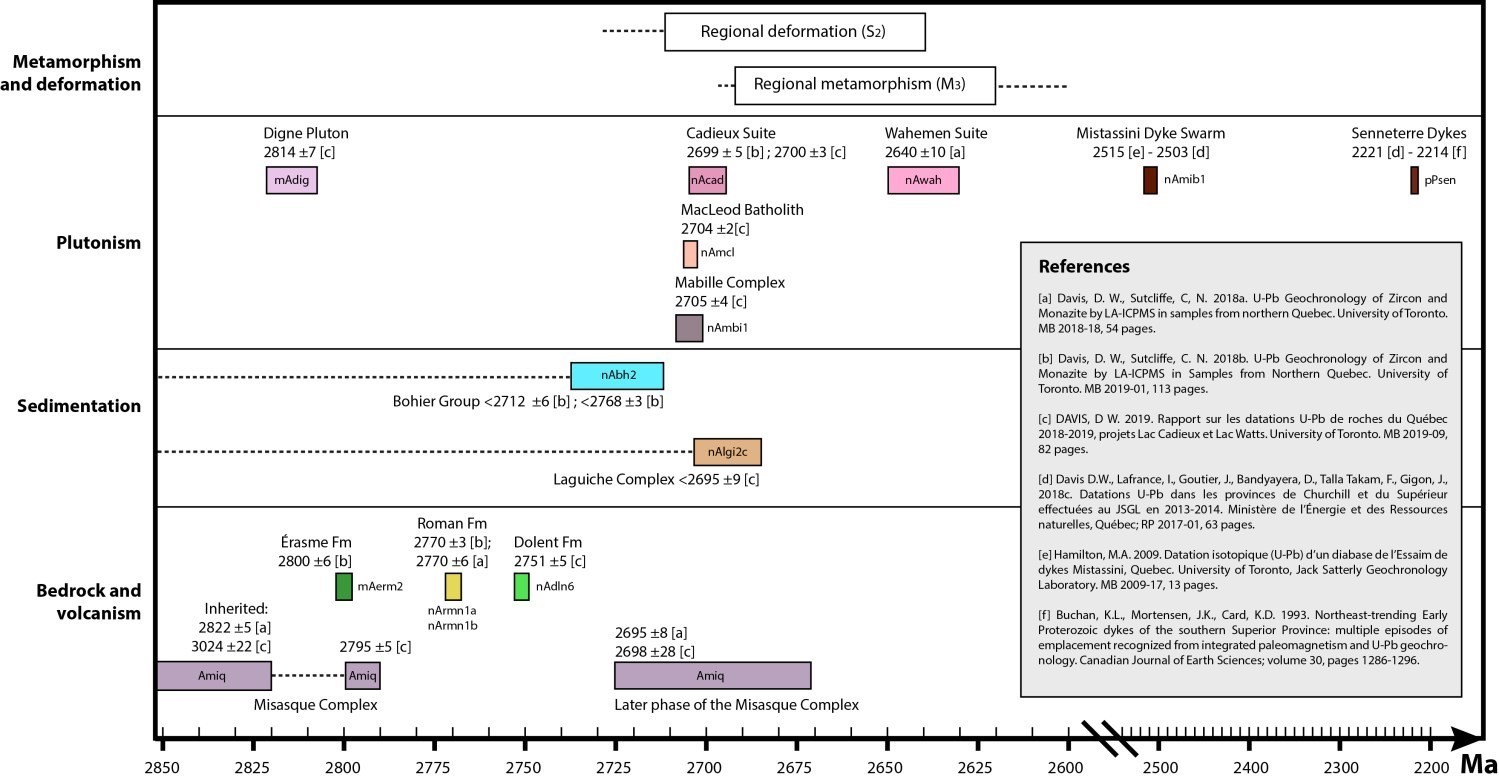
The Misasque Complex (Amiq; Talla Takam et al., in preparation) consists of TTG-type polyphase gneissic and intrusive bedrock. The spread of Archean ages obtained in rocks of the Misasque Complex demonstrates the existence of several generations of zircons and reflects the heterogeneity, mixing and complexity of this unit which contains several phases in diffuse contact. Even if magmatic crystallization ages (U-Pb on zircons) obtained in homogeneous tonalites of the Misasque Complex are younger than those of the Digne Pluton, inherited ages (3024 Ma and 2822 Ma) and the presence of undated gneissic units in the Misasque Complex both suggest that early phases could predate intrusion of the Digne Pluton.
The Digne Pluton (mAdig; new unit, 2814 ±7 Ma; Davis, 2019) differs from its adjacent unit, the Misasque Complex, by its homogeneity, the absence of gneissic texture, the expression of a poorly developed foliation and the presence of quartz phenocrystals. The Digneous Pluton consists of a tonalite and leucocratic biotite-muscovite granodiorite intrusion that intrudes into the oldest phases of the Misasque Complex. Since the latter is polyphase, it also contains much younger intrusive phases, whose emplacement postdates that of the Digne Pluton.
The Maingault Complex (nAmng; new unit) occupies the southern part of the Cadieux Lake map and includes three subunits of locally migmatized intrusive and gneissic rocks: 1) tonalite and quartz diorite (nAmng1); 2) gabbro, diorite and amphibolite (nAmng2), and 3) peridotite (nAmng3).
The Upper Eastmain Greenstone Belt (UEGB), which rests on the bedrock, is composed of two major groups: the René Group (Are), which consists mainly of volcanic rocks, and the Bohier Group (nAbh), which groups of sedimentary rocks. The René Group is presented as a succession of volcanic episodes corresponding to four formations (Beauchamp et al., 2018). From the base to the top of the volcanic pile, this succession consists of the Érasme Formation (mAerm; 2800 ±6 Ma, Davis and Sutcliffe, 2018b), the Roman Formation (nArmn; 2770 ±3 Ma, Davis and Sutcliffe, 2018b; 2770 ±6 Ma, Davis and Sutcliffe, 2018a) and the Clément Formation (nAcln; <2770 Ma). Only the Dolent Formation (nAdln), which represents the upper part of the René Group, is visible in the area. Its stratigraphic position (2751 ±5 Ma; Davis, 2019), established during the field campaign of the Cadieux Lake area, indicates that it would be the youngest formation of the René Group. However, it is possible that the emplacement of the Dolent Formation is synchronous with the Clément Formation that has been described in the southern branch of the UEGB.
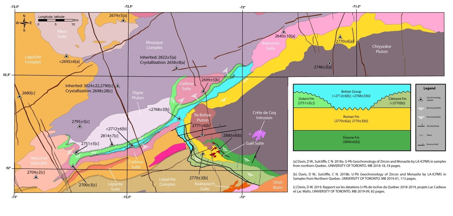
The Dolent Formation (nAdln; Beauchamp et al., 2018) groups volcanic rocks of the western and northern branches, as well as those of the northern edge of the eastern branch of the UEGB. It is divided into six informal units. Unit nAdln6 was added as part of this work to describe a thin felsic tuff unit present in the axial part of a regional fold at the western end of the UEGB. Mafic and ultramafic sills (nAdln3) characterize the base of the formation. Sulphidic chert and iron formation (nAdln5) and felsic tuff (nAdln6) units are interstratified with overlying basalt layers (nAdln1). The youngest unit consists of ultramafic volcanic rocks and ultramafic sills (nAdln4). The summit contact is characterized by a fault masking an unconformity above which polymictic conglomerates of the Bohier Group are deposited.
The Bohier Group (nAbh; Couture, 1987) is divided into four informal units, but the two basal units (nAbh1 and nAbh1a) are not present on the map of Cadieux Lake. The polymictic conglomerate unit (nAbh2) outcrops to the south of the western branch of the UEGB and laterally and progressively changes to a tuff unit (nAbh3; new unit). In order to constrain the deposition of detrital sedimentary rocks of the UEGB, two conglomerate samples were dated. The pale matrix conglomerate is located in the centre of Bohier Island and is mainly composed of clasts of tonalite and felsic volcanic rocks. Only one zircon population has been identified (2768 ±3 Ma; Davis and Sutcliffe, 2018b). Age indicates that this conglomerate is mostly derived from the erosion of the synvolcanic Île Bohier Pluton and volcanic rocks of the Roman Formation. Zircons of the second conglomerate dated are distributed around two ages, 2712 ±6 Ma and 2836 ±10 Ma (Davis and Sutcliffe, 2018b). The youngest zircon population dated at 2712 ±6 Ma (Davis and Sutcliffe, 2018b) represents the maximum sedimentation age for the rocks of the Bohier Group.
Opinaca Subprovince
Klippes of foliated biotite-hornblende ± magnetite quartz diorite, tonalite and diorite (lithological unit I2b), locally gneissic and migmatized, were mapped in the Lavallette Lake area. These isolated bodies within the sedimentary basin of the Laguiche Complex could be older.
Neoarchean metasedimentary rocks of the Laguiche Complex (<2695 ±9 Ma; Davis, 2019) represent the bulk of this subprovince. They are separated into two tectonometamorphic domains by the Eastmain-Sorbier Shear Zone. The northern domain exposes paragneiss (nAlgi2a), diatexite derived from the melting of paragneiss, intermediate intrusive rocks and anatectic granite (nAlgi4b). The southern domain exposes less migmatized sedimentary rocks that generally contain <20% mobilisate. These consist of paragneiss (nAlgi2c) and biotite ± garnet ± cordierite metatexite (nAlgi3a). Rocks of unit nAlgi2c differ from unit nAlgi2a by their equivalent potassium content (%) and by their equivalent thorium content (ppm) which are significantly higher. From a geochemical point of view, paragneiss of units nAlgi2a and nAlgi2c are thought to have originated from the erosion of TTG-type bedrock, and their protolith would consist of wacke (see Lithogeochemistry). Because of their similar geochemistry, it is not possible to rule out the hypothesis that metasedimentary rocks of units nAlgi2a and nAlgi2c have a common origin. Thin layers of polymictic conglomerate containing migmatized floating fragments (nAlgi10) are isolated in the Eastmain-Sorbier Shear Zone near Lavallette Lake.
The Mabille Complex (nAmbi; new unit) consists mainly of homogeneous tonalite (2705 ±4 Ma, Davis, 2019) and biotite ± magnetite quartz diorite (unit nAmbi1). Of lesser importance, units nAmbi2 (foliated biotite and magnetite granite and granodiorite), nAmbi3 (foliated hornblende and magnetite gabbro and diorite), nAmbi4 (foliated peridotite with cumulate structure), and nAmbi5 (amphibolitized basalt, garnet amphibolite, and tuff) are only slightly exposed.
A wide variety of intrusive, syntectonic to late-tectonic rocks intrude into the Opinaca sedimentary basin. The Lépante Suite (nAlpn; new unit) consists of foliated quartz monzodiorite and monzodiorite outcropping within the Eastmain-Sorbier Shear Zone. Several rounded to lenticular, and foliated, ultramafic bodies belonging to the Sorbier Mafic-Ultramafic Suite (nAsrb; new unit) and the Dominique Ultramafic Suite (nAdmn; new unit) clearly cut rocks of the Laguiche Complex. They appear more or less aligned along the Sorbier Shear Zone and the outline of the MacLeod Batholith. The relief of the Otish Mountains is occupied by the Pisim Pluton (nApsm; new unit), consisting of slightly foliated tonalite and granodiorite, by the Barou Intrusion (nAbru; Beauchamp et al., 2018), heterogeneous massive granite, and by the Martel Suite (nAmrt; Beauchamp et al., 2018) consisting of banded muscovite-garnet granite. Finally, granitic lithological units I1Ba and I1Bb, which cut metasedimentary rocks, seem to have been emplaced very late in the tectonometamorphic history of the area.
Intrusive Units Cutting Both Subprovinces
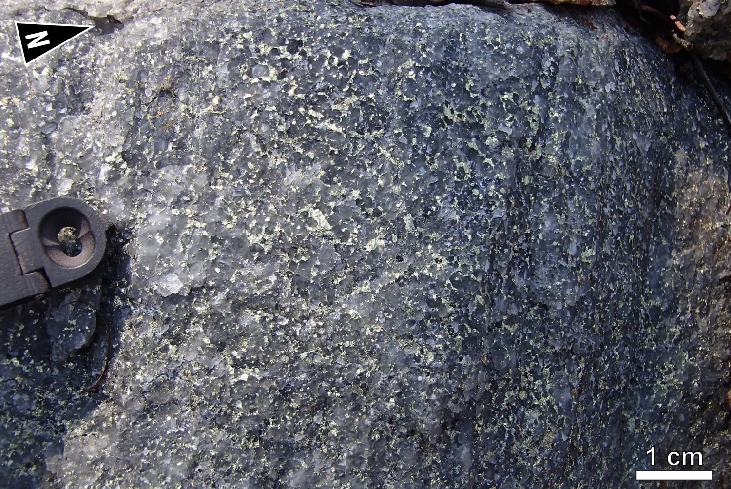
The MacLeod Batholith (nAmcl; new unit), which forms a large intrusive mass (25 km by 15 km) of hornblende-biotite-magnetite granodiorite and quartz monzodiorite occupies the central part of the mapped area. The Cadieux Suite (nAcad; Beauchamp et al., 2018) consists of foliated quartz monzodiorite and granodiorite having a characteristic K-feldspar porphyritic texture. It cuts the southern part of the UEGB and masks the contact between the Opatica and Opinaca subprovinces. Ages obtained for intrusive rocks of the MacLeod Batholith (2704 ±3 Ma; Davis, 2019) and the Cadieux Suite (2700 ±3 Ma; Davis, 2019, 2699 ±5 Ma; Davis and Sutcliffe, 2018b) suggest that they are contemporaneous. Finally, the Wahemen Suite (nAwah; Talla Takam et al., in preparation), consisting of muscovite-biotite-garnet granite and pegmatite, is one of the youngest Archean units in the Cadieux Lake area (2640 ±10 Ma; Davis and Sutcliffe, 2018a).
Neoarchean and Paleoproterozoic Mafic Dykes
The study area is cut by three Neoarchean and Paleoproterozoic swarms of mafic dykes that cut all units of the area. SSE-NNW oriented dykes of massive gabbronorite, with a common porphyritic phase containing centimetric plagioclase phenocrystals, belong to the Mistassini Dyke Swarm (nAmib; 2515-2503 Ma). The Senneterre Dykes (pPsen; 2221-2216 Ma), of gabbroic to gabbronoritic composition, are WSW-ENE oriented. Finally, N-S oriented gabbronorite dykes could be related to the Lac Esprit Dykes swarm (pPest; 2069 ±1 Ma).
Lithogeochemistry
The lithogeochemistry of units in the Cadieux Lake area is presented separately in tabular form.
Structural Geology

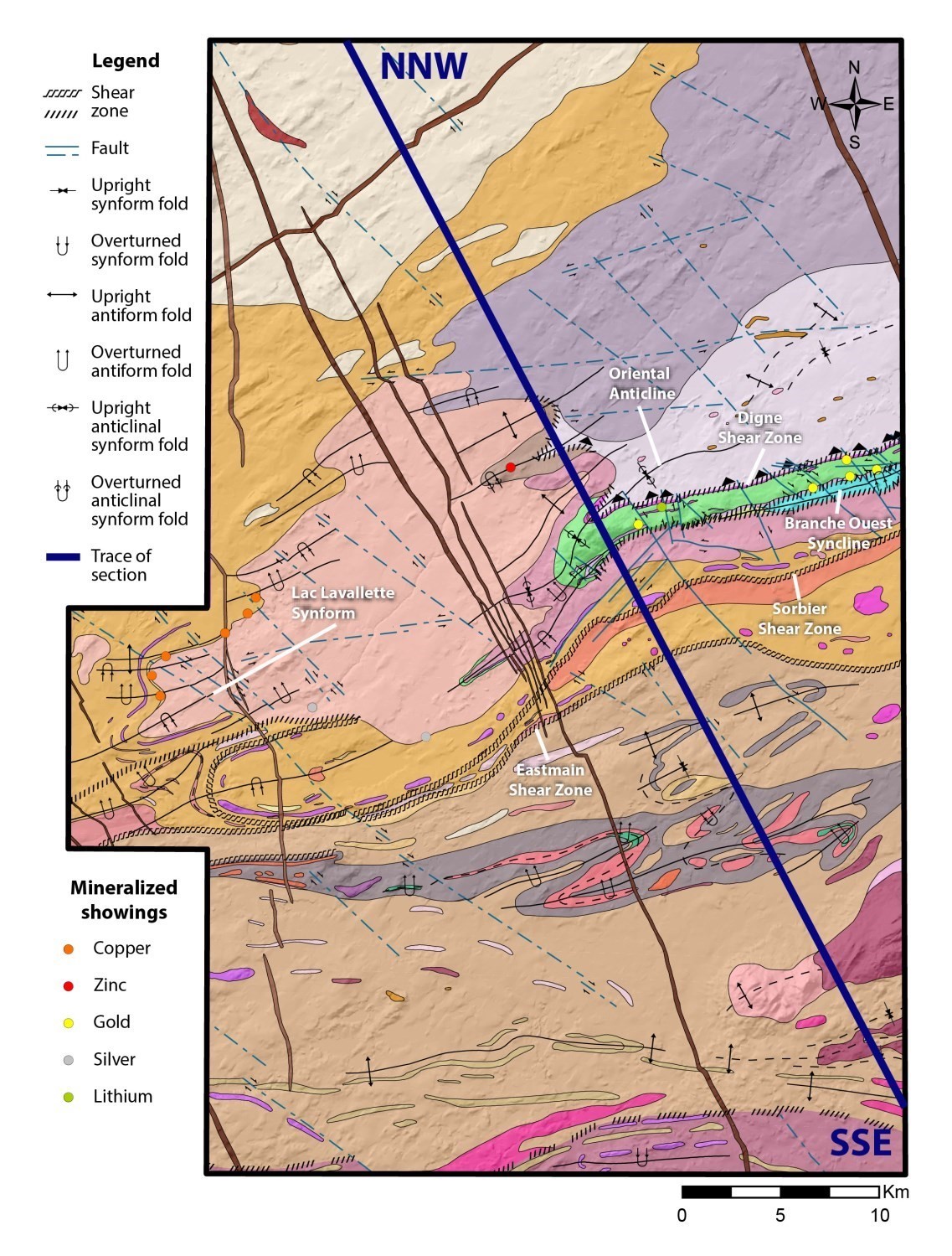
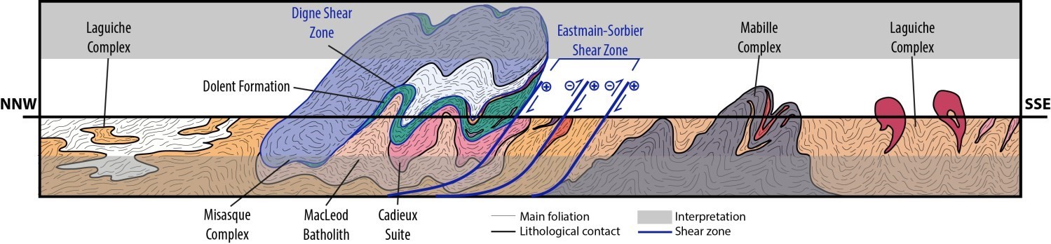
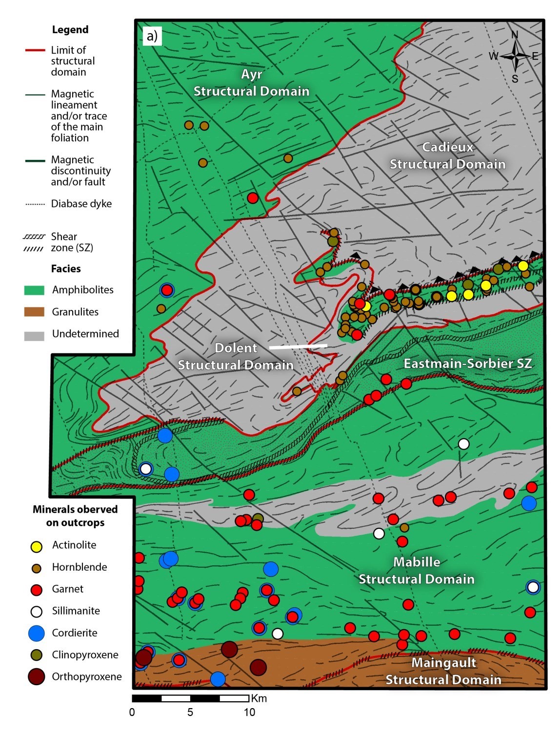
The Cadieux Lake area displays a complex architecture involving polyphase tectonics. Lithological, structural and geophysical criteria allow the area to be subdivided into six structural domains. The Cadieux (DScad), Dolent (DSdol) and Maingault (DSmai) domains belong to the Opatica Subprovince. In the Opinaca Subprovince, the Eastmain-Sorbier Shear Zone (ZCesb) separates the Ayr Domain (DSayr) to the north and the Mabille Domain (DSmbi) to the south. Three deformation phases have been identified and designated D1, D2, D3 in the Cadieux Lake area. The D2 fabric, described in this bulletin, corresponds to the main regional foliation. It refers to D2 deformation used by Couture (1987) and Beauchamp et al. (2018), D1 described by Roy (1988) and Dn in most records of the Structural Lexicon. The structural section presents an interpretation of the geometry of the main units of the region in a vertical plane oriented NNW-SSE. On the surface, it is based on structural field observations, while at depth it is purely interpretative.
Primary Structures
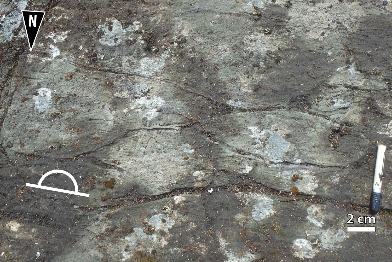

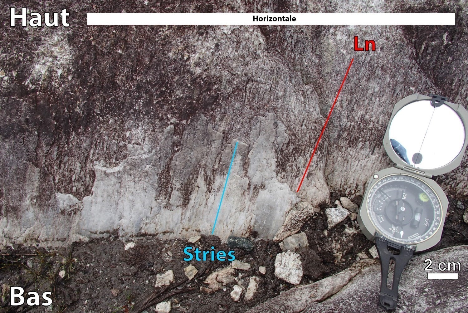
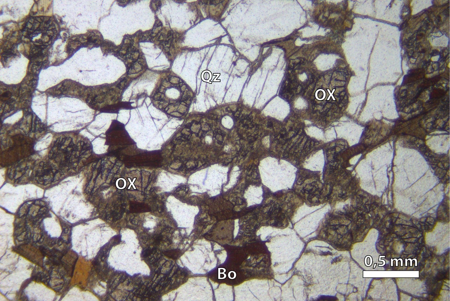
Primary structures are well preserved within the Dolent Structural Domain. Stratification is generally transposed in the main S2 fabric, which is not the case at the western end of the UEGB, where stratification –at a high angle to the trace of S2 foliation– and the closure of regional folds are clearly visible on the map of the vertical gradient of the high-resolution magnetic field (Wade et al., 2014). The morphology of basalt pillows of the Dolent Formation indicates that the polarity of the volcanic sequence is reversed. The Dolent Formation is underlain by bedrock associated with the Digne Pluton to the north. Metasedimentary rocks of the Laguiche Complex located in the Ayr and Mabille structural domains have locally preserved relics of primary bedding. Compositional banding within paragneiss layers consists of alternating beds that are richer in BO ± CD ± FB, originally more argillaceous, and bands that are poorer in BO ± GR, which are derived from sandstone beds. Some outcrops in the Dominique and Sorbier suites expose primary magmatic bedding.
D1 Deformation Phase
The D1 deformation phase is characterized by S1 foliation preceding S2 regional foliation. On outcrops, it is especially visible in the hinge zones of P2 folds (eastern end of the UEGB) and in the Bohier Island area (Beauchamp et al., 2018). In thin sections, S1 foliation is defined as a discrete preferential alignment of phyllosilicates at a strong angle with S2 foliation.
Digne Shear Zone (CSdig)
The Digne Shear Zone marks the sharp contact between the Digne Pluton, which forms part of the bedrock, and UEGB rocks in the stratigraphic roof (structural wall). This shear zone, generally oriented ENE-WSW and folded by regional folds (P2), seems to have developed during D1 deformation phase. It is characterized by the presence of very well-developed L>>S tectonites. The various kinematic indicators observed on outcrops indicate that the CSdig accommodated reverse movement. This deformation could possibly be caused by gravitational sinking of volcano-sedimentary rocks beneath granitoids of the Digne Pluton, or by overthrusting of rocks of the Digne Pluton on the Dolent Formation.
D2 Deformation Phase
The D2 deformation phase corresponds to the regional deformation phase responsible for ENE-WSW folds (P2) and associated foliation (S2). It is prior to 2640 Ma (Davis and Sutcliffe, 2018a) corresponding to the age of the Wahemen Suite which is not affected by deformation and metamorphism. S2 foliation is oriented ENE-WSW and moderately dipping towards the north or south. It refers to secondary tectometamorphic foliation in all structural domains, gneissosity in the Cadieux Structural Domain and migmatitic banding in the Ayr and Mabille domains. It is defined by the alignment of ferromagnesian minerals and by the stretching and flattening of pillows, clasts and olivine cumulates. Structures generated during this period are consistent with a NNW-SSE shortening episode. The associated L2 lineation is defined by the stretching of the main metamorphic minerals or anisotropic objects such as clasts in conglomerate. The orientation of lineations is highly variable according to the structural domain, and the plunge varies from shallow to moderate. Several regional folds (P2) visible on magnetic maps were interpreted thanks to opposite dips of structures and stratigraphic views. They form a succession of straight to overturned folds characterized by axial planes oriented ENE-WSW. Their axes generally plunge towards the ENE or NE.
Shear Zones Within the UEGB
Shear zones in the UEGB, which are straight and coplanar with the S2 fabric, appear to have formed during the main deformation phase. Shear zones oriented WSW and moderately dipping towards the NNE developed preferentially at the contact between lithological units, for example at the contact between volcanic rocks and conglomerates. The southern end of the western branch of the UEGB is characterized by an increase in the deformation rate. In the western branch of the UEGB, conglomerate layers of the Bohier Group form L-S tectonites. The high degree of flattening and stretching of clasts means that they are in places difficult to recognize in the matrix. Several Z-shaped drag folds and sigmoid clasts indicate a reverse dextral movement. Near the southern contact of the UEGB, basalt pillows are so flattened that they form 0.1 m to 1 m long bands, and ultramafic rocks (nAdln4) become chlorite-talc-tremolite-magnetite shale.
Eastmain-Sorbier Shear Zone (ZCesb)
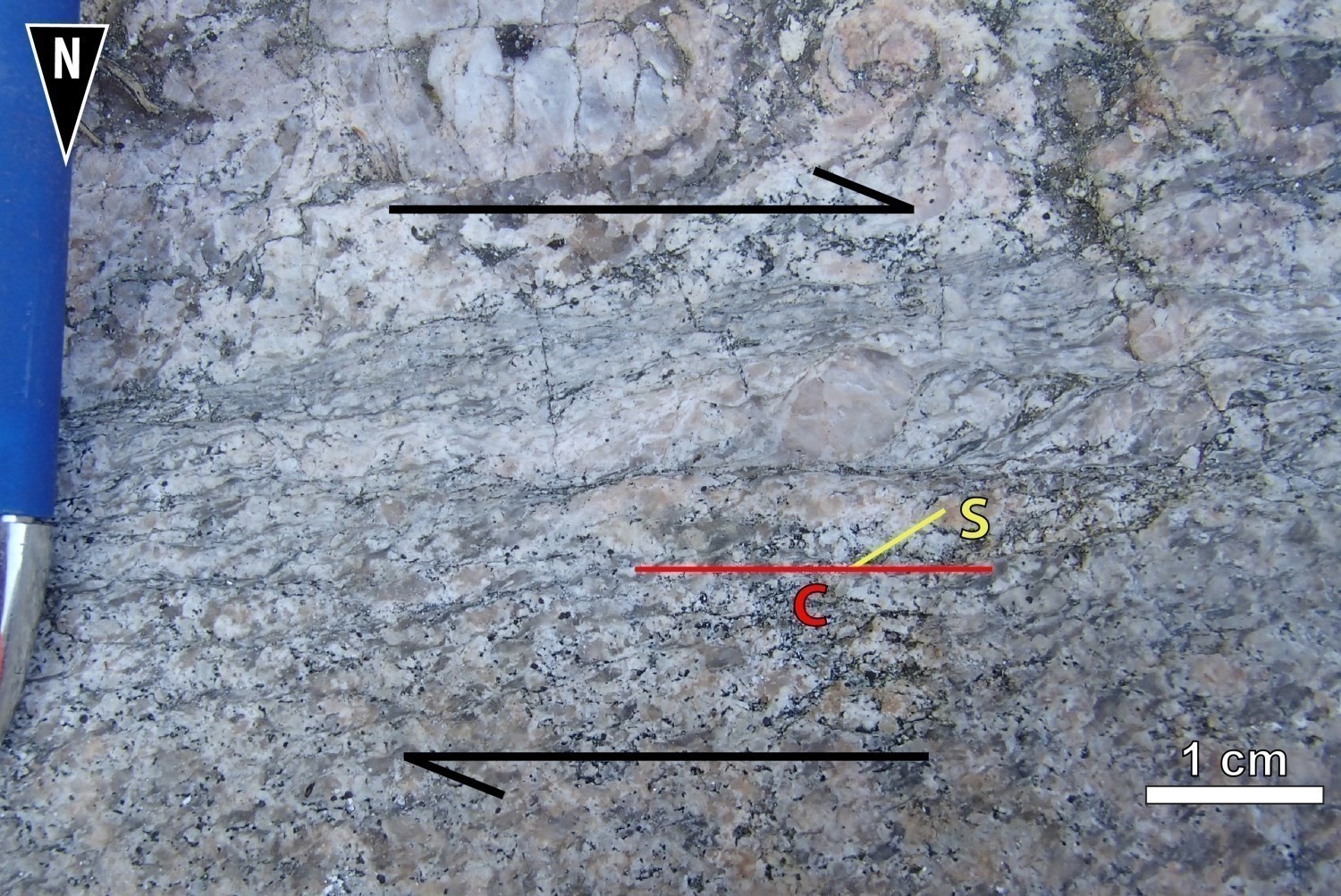
The Eastmain-Sorbier Shear Zone, which divides the Cadieux Lake map into two large metasedimentary rock units, forms the boundary between the Ayr (DSayr) and Mabille (DSmbi) domains to the north and south respectively. The ZCesb includes the Eastmain Shear Zone, located at the southern boundary of the domain and the Sorbier Shear Zone, included in the latter and which follows the alignment of mafic-ultramafic bodies of the Sorbier Suite. The Ayr Structural Domain, characterized by a high rate of partial melting, is believed to have formed at a greater depth than the Mabille Domain. The implication of a vertical movement prior to horizontal shearing is interpreted since it helps to explain the juxtaposition of two metamorphic domains generated at different crustal layers. Kinematic indicators and lineations having shallow plunge indicate a dextral horizontal movement. Some mylonitic fabrics of the ZCesb are folded by P2 and P3 folds, indicating that ductile structures of this domain developed before the formation of regional folds. The dextral movement appears to be younger, i.e. late deformation to post deformation relative to D2.
D3 Deformation Phase
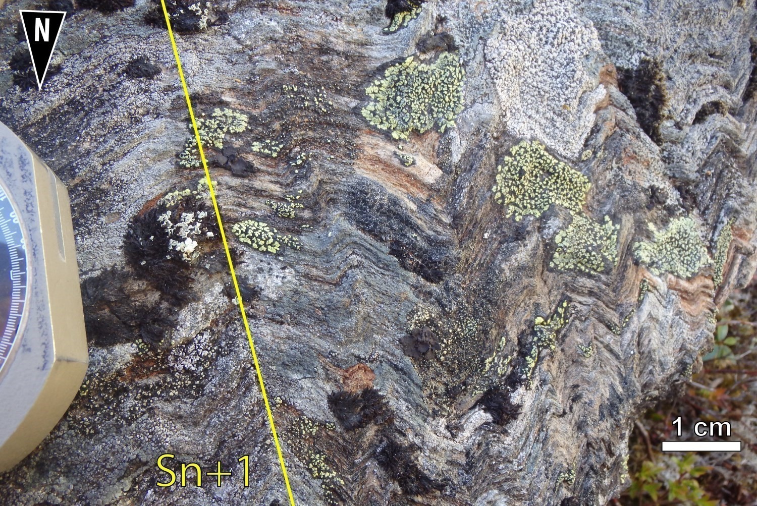
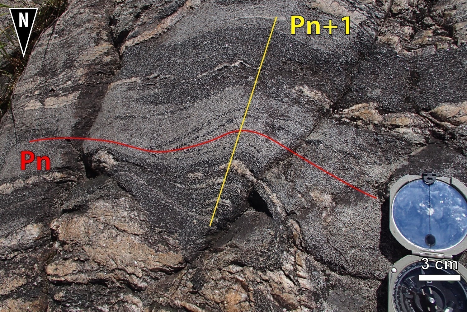
The D3 deformation phase represents the continuation of D2 regional deformation. It is characterized by S3 spaced crenulation cleavage of P3 folds axial plane, generally chevron-shaped, and oriented NNE-SSW. The D3 phase occurs mainly in the Dolent Structural Domain and within deformation corridors, where it folds the earlier fabrics. Type 3 fold interferences (Ramsay, 1962) are observed in unit I2b and in conglomerates of the Bohier Group. Couture (1987) had also documented hook and mushroom interference patterns (Type 2, Ramsay, 1962) in tuff associated with ultramafic flows of the Dolent Formation.
Metamorphism
Several episodes of prograde metamorphism have been documented in the Eeyou Itschee James Bay region (Morfin et al., 2013; Gigon and Goutier, 2017, Rhéaume-Ouellette et al., 2016, Côté-Roberge et al., 2018). Remains of M3 metamorphism, which are present in all rocks with the exception of diabase dykes, are the best preserved. This Neoarchean episode was spread over a long period and affected all rocks in the area (Opinaca and Opatica subprovinces). Metamorphism M3 started ~2702 Ma and seems to have faded away at ~2602 Ma. It comprises two metamorphic peaks: a first one (M3') at low pressure and high temperature at 2670 Ma, followed by cooling. A second event (M3''), displaying Barrovian-type metamorphism with isothermal cooling, dated at 2645 Ma (Côté-Roberge et al., 2018).
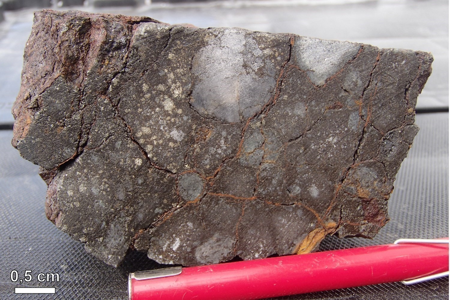
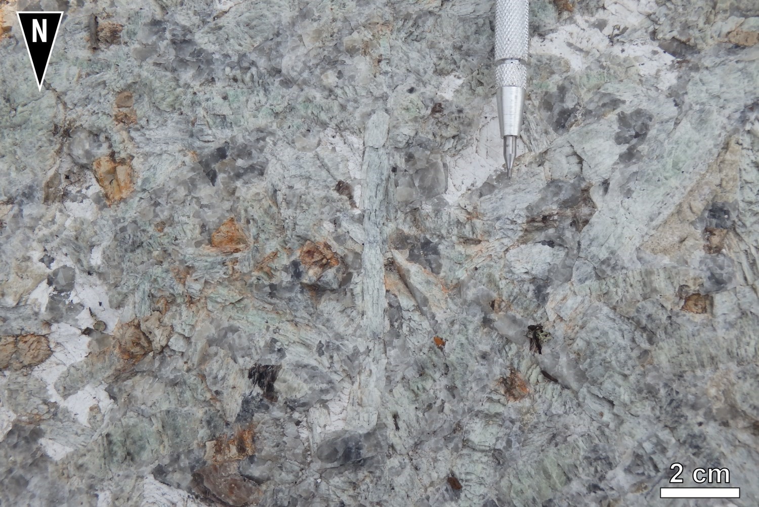
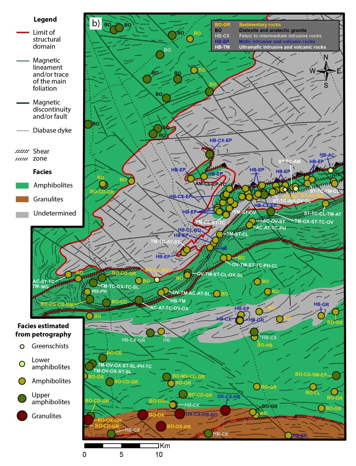
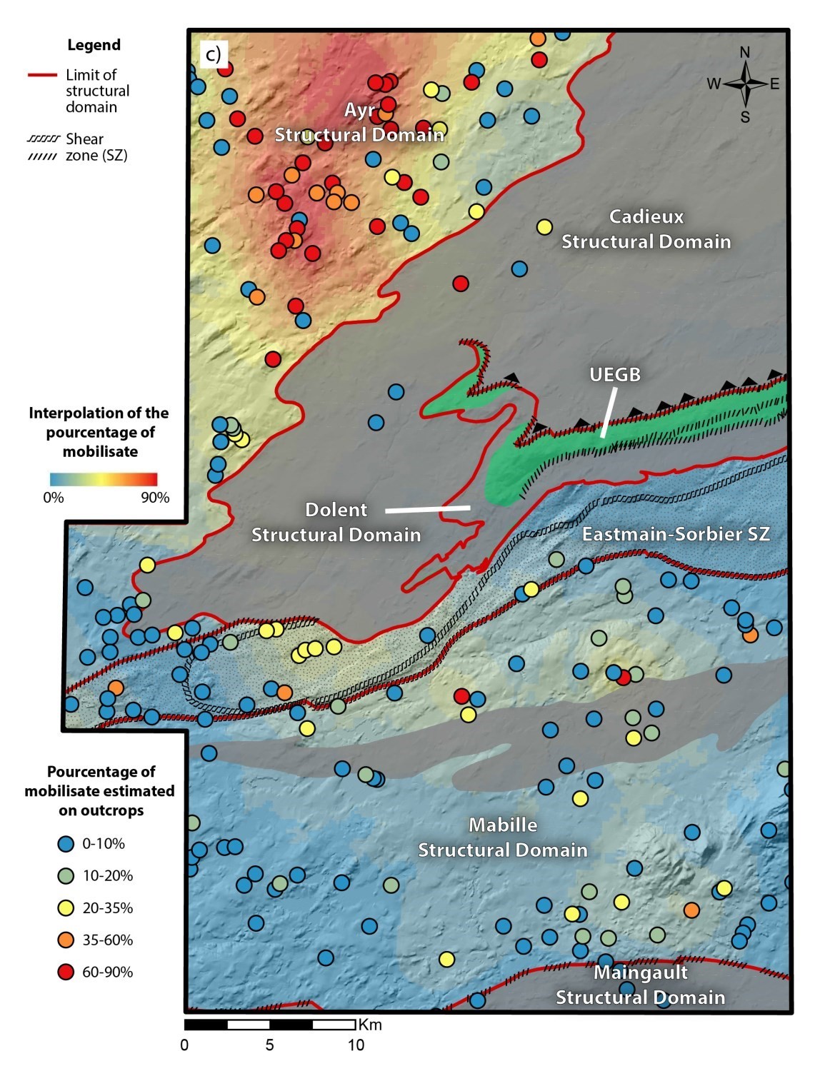
The metamorphic maps (Figure A and Figure B) opposite were produced thanks to macroscopic observations made on outcrops and petrographic observations made with a polarizing microscope on 143 representative samples. Practically all samples are characterized by high temperature metamorphic conditions, having reached amphibolite facies. At the southern end of the Cadieux Lake map, rocks have reached the granulite facies since orthopyroxene was noted in thin sections on samples from three paragneiss outcrops of unit nAlgi2c of the Laguiche Complex (outcrops 18-LP-6097, 18-MP-5080 and 18-WM-3100). Figure C illustrates an interpolation of the percentage of mobilisate in migmatites of the Laguiche Complex. This map indicates a clear increase in the partial fusion melting in the Ayr Structural Domain. The presence of these rocks consisting of ≥50% mobilisate suggests a greater heat flow towards the NW corner of the map.
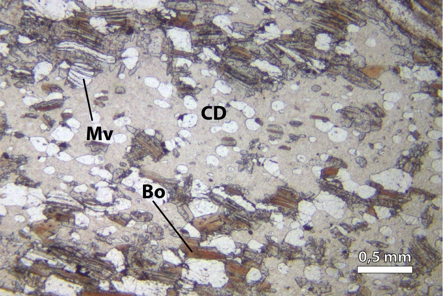
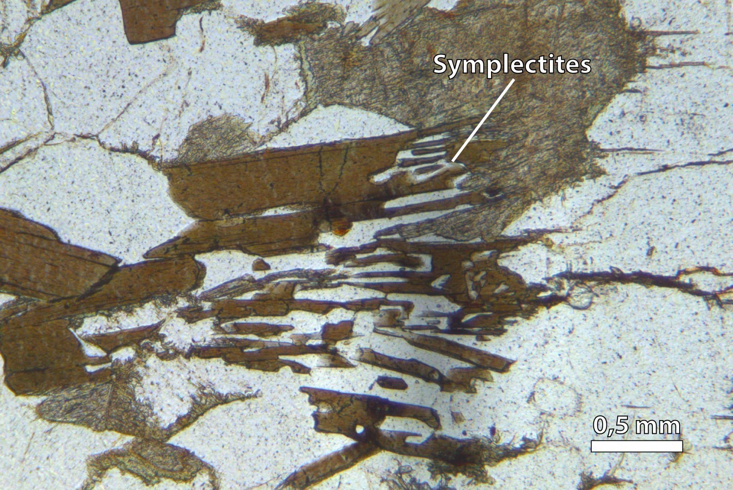
Sedimentary rocks of the Cadieux Lake area are located on the edge of the Laguiche Complex. They are composed of a QZ-FP-BO ± GR ± CD ± SM assemblage and have been metamorphosed to the amphibolite facies. Some areas comprise cordierite ± sillimanite/fibrolite paragneiss typical of the upper amphibolite facies. In the southern part of the map, orthopyroxene porphyroblasts retrograded to an amphibole-chlorite assemblage indicate that the granulite facies was reached punctually, then rocks were retrograded to the lower amphibolite facies, and finally to the greenschist facies. Thin sections of migmatitized paragneiss of units nAlgi2a and nAlgi2c show that biotite flakes are aligned according to the main fabric. Small poekiloblastic garnet grains are common and irregularly distributed, in addition to cutting foliation. They are late tectonic to post tectonic. Masses of cordierite poekiloblasts replaced by yellowish pinnite and fibrolite porphyroblasts are observed in some of the more pelitic beds of the migmatized metasedimentary sequence, especially in the SW part of the map. The presence of cordierite indicates that rocks have undergone low-pressure metamorphism. Some thin sections display biotite-quartz, biotite-plagioclase and biotite-cordierite symplectitic intergrowth textures corresponding to relics of anatectic fluid.
Unit nAlgi4b consists mainly of diatexite, anatectic granite and, to a lesser extent, metatexite resulting from melting of paragneiss and intermediate intrusive rocks. Mobilisate and metasedimentary rocks contain a QZ-PG-FK-BO ± GR assemblage. No orthopyroxene has been observed in the field and in thin sections, implying that the granulite facies has not been reached.
Mafic rocks of the Dolent Formation and Mabille Complex are characterized by pervasive hornblende. The mafic rock prograde assemblage consists of HB-PG-EP ± GR ± SN ± CX. Their paragenesis is stable over a wide range of pressures and temperatures, but it is a typical assemblage of the amphibolite to upper amphibolite facies. Mafic-ultramafic sills of the Dolent Formation (nAdln3) are characterized by AM-(HB ± AC ± CG)-PG-EP-BO-TC assemblages. The typical assemblage of unit nAdln4 consists of ST-TM-CL-TC-MG ± OV ± AT ± PH. Like mafic rocks of the UEGB, ultramafic rocks (nAdln3, nAdln4) have assemblages typical of the amphibolite facies.
The metamorphic peak reached by rocks of the Sorbier Mafic-Ultramafic Suite and Dominique Ultramafic Suite seems to be at the upper amphibolite facies, comprising a ST-TC-TM-MG ± OV ± OX ± AT ± PH ± SL assemblage. Anthophyllite forms acicular porphyroblasts that commonly cut the main foliation defined by tremolite. Tremolite is only stable under amphibolite facies conditions and at low pressures (below ~1.2 GPa; Winter, 2010). According to Bucher and Grapes 2011, orthopyroxene can be formed from 650 °C, i.e. from the upper amphibolite facies. These porphyroblasts are partially to completely replaced by talc during retrograde metamorphism, resulting in whitish nodules on the surface of outcrops.
The mineralogical composition of gneissic and felsic to intermediate intrusive rocks in the region does not provide useful information on the metamorphic conditions that these rocks underwent.
Economic Geology
The Cadieux Lake area has prospective zones for five types of mineralization. They are listed in order of importance:
- Mineralization associated with porphyry intrusions and skarns (Cu-Mo-Ag-Au-W);
- Exhalative sulphide mineralization (Ag-Au-Cu-Mn);
- Orogenic-type lode gold mineralization;
- Lode gold mineralization in iron formations;
- Mineralization in granitic pegmatites (Li-Be-Ta).
The table of mineralized zones below presents the results of analyses for the 15 known mineralized zones in the area:
Mineralized Zones in the Cadieux Lake Area
| Name | Contents | |
|---|---|---|
| Mineralization Associated with Porphyritic Intrusive Rocks | ||
| Cornu | 13.1 ppm Ag (G); 856 ppb Au (G); 3360 ppm Cu (G) | |
| Name | Contents |
|---|---|
| Exhalative Sulphide Mineralization | |
| Dejour-NE | 25 ppm Ag (G); 3.467 g/t Au (G); 705 ppm Cu (G); 1338 ppm Mn (G) |
| Orogenic-Type Lode Gold Mineralization | |
| Dejour-SW | 16.8 ppm Ag (G); 121 ppb Au over 0.2 m (D); 1.43 ppm Cd over 0.7 m (D); 5075 ppm Zn (G) |
| Exko Extension-NE | 1.53 g/t Au over 1 m (D) |
| Exko Showing | 5.25 g/t Au (D); 3.5 ppm Ag (G); 3550 ppb Au (G); 994 ppm Cu (G); 1203 ppm Mn (G); 848 ppm Zn (G) |
| Lode Gold Mineralization in Iron Formations | |
| Éch. Q17029 | 2.25 ppm Ag (G); 1570 ppb Au (G) |
| Mineralization Associated with Porphyry Intrusive Rocks and Skarns | |
| Lac Macleod | Main Zone reported resources: 18.18 Mt at 0.60% Cu, 0.094% Mo, 4.48 g/t Ag and 0.06 g/t Au, and inferred resources: 1.862 Mt at 0.35% Cu, 0.078% Mo, 3.41 g/t Ag and 0.04 g/t Au (Cook et al., 2008); 54.89 ppm Ag (G); 4460 ppb Au (G); 72 800 ppm Cu (G); 6300 ppm Mo (G) |
| Lac Macleod-NE | 24 ppm Ag (G); 2000 ppb Au over 16.6 m (D); 26 500 ppm Cu (G); 12 200 ppm Mo (G) |
| ML-06-123 | 9.69 ppm Ag over 2 m (D); 161 ppb Au over 2 m (D); 9999.6 ppm Cu over 2 m (D); 180 ppm Mo over 0.4 m (D) |
| ML-06-128 | 5 ppm Ag over 0.6 m (D); 136 ppb Au over of 0.6 m (D); 9700 ppm Cu over 0.6 m (D); 900 ppm Mo over 0.6 m (D) |
| Pointe Richard | South Zone reported resources: 1.47 Mt at 0.72% Cu, 0.18% Mo, 0.54 g/t Au and 19 g/t Ag (Winter, 2007); 53 ppm Ag (G); 1450 ppb Au (G); 24 000 ppm Cu over 2 m (D); 13 000 ppm Mo (G) |
| Pointe Rocky | 26 ppm Ag (G); 91 100 ppm Cu (G); 3400 ppm Mo over 3.6 m (D) |
| Windy-Cible 4-3 | 14.2 ppm Ag (G); 342 ppb Au (G); 2800 ppm Cu (G); 386 ppm Mo (G) |
| Mineralization in Granitic Pegmatites | |
| Éch. S894341 | 483 ppm Be (G); 7530 ppm Cs (G); 21 900 ppm Li (G); 271 ppm Nb (G); 1970 ppm Rb (G); 1030 ppm Ta (G) |
| Undetermined Type of Mineralization | |
| Windy Mountain | 0.8 ppm Ag (T); 268 ppm Co (T); 728 ppm Cu (T); 527 ppm Ni (T); 8800 ppm Zn (T) |
(G): Selected sample; (T): Trench; (D): Diamond drilling
The table of lithogeochemical analyses of metals of economic interest provides the location, description, and analytical results for 44 samples selected to assess the economic potential of the region.
Prospective zones identified on the geological map are ranked in order of importance and described in the following section.
Cu-Mo-Ag-Au-W Mineralized System at the Contact Between the MacLeod Batholith and Laguiche Complex Paragneiss

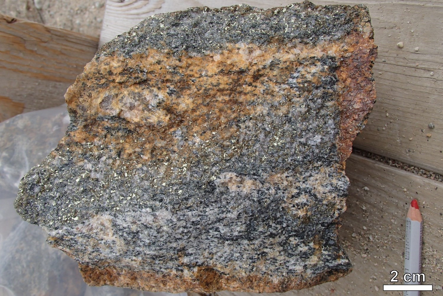
The MacLeod prospective zone groups eight Cu-Mo-Ag-Au-W mineralized zones: Cornu (new), Lac MacLeod, Lac MacLeod-NE, Pointe Rocky, Pointe Richard, ML-06-128, ML-06-123 and Windy Cible 4-3. The Main Zone of the MacLoed deposit, which is the most important mineralization for this type, is 1200 m long by 50 m thick and is located on the flank of an antiform. It contains reported resources of 18.18 Mt at 0.60% Cu, 0.094% Mo, 4.48 g/t Ag and 0.06 g/t Au (Cook et al., 2008). Mineralization appears as veinlet, dissemination, cluster and stockwerk of chalcopyrite with lesser amounts of molybdenite, pyrite, pyrrhotite, bornite and chalcocite. The majority of sulphides are located on the edge of the MacLeod Batholith, in migmatitized paragneiss of the Laguiche Complex. However, some of the mineralization is also contained in the intrusion. The highest contents are hosted in a biotite-actinolite-chlorite schist located 25 m from contact with the batholith.
The work achieved by the Ministère has documented some of the common characteristics of the mineralization found in the MacLeod prospective zone:
- Mineralization consists of veinlets, dissemination, clusters and stockwerks of chalcopyrite with lesser amounts of molybdenite, pyrite, pyrrhotite, bornite and chalcocite. The majority of sulphides are located on the edge of the MacLeod Batholith, in migmatitized paragneiss of the Laguiche Complex. The most significant contents are found in a biotite-actinolite-chlorite schist located 25 m from the contact with the batholith. However, part of the mineralization is also contained within the intrusion;
- Mineralization is associated with zones of intense silicification (silica flooding). The Lac MacLeod deposit's discovery outcrop (18-FM-2074) exhibits a 10 m to 15 m silicification zone rich in chalcopyrite and molybdenite. This zone is located at the contact between white pegmatite to the north and paragneiss derived from wacke to the south. Chalcopyrite forms cement around quartz grains, giving the rock a granoblastic texture, suggesting that a significant part of mineralization predates the regional metamorphism and migmatization episode;
- Alteration in the MacLeod Batholith is zoned. Potassic alteration (biotite, magnetite and K-feldspar in variable amounts) is present in the centre of the intrusion. Propylitic alteration (quartz, chlorite and epidote) and silicification are observed at the edge;
- Deformation played a major role in the emplacement or remobilization of mineralization. Indeed, the main lithology hosting cupper mineralization is a heavily deformed and crenulated schist located in the nose or flanks of regional folds, suggesting a strong link between P2 folds and mineralization;
- In drill cores, higher amounts of chalcopyrite and molybdenite are observed near boudinaged and dismembered injections or quartzofeldspathic mobilisate;
- Locally, chalcopyrite is associated with late hematite-epidote veinlets that cut regional foliation sharply, which suggests that some of the mineralization was emplaced or remobilized by a late brittle fracturation episode;
- A few QZ-HM-EP hydrothermal breccias very slightly mineralized were documented in drill cores of the MacLeod Batholith.


The Cu-Mo-Ag-Au-W metal association in an intrusive rock, mineralization styles and alteration zoning all suggest mineralization of magmatic-hydrothermal origin and partially porphyritic. However, several characteristics typical of porphyry deposits were not observed, including the presence of porphyritic dykes, the zonality of mineralization and the presence of breccia pipes. Mineralization that is hosted in biotite-actinolite-chlorite schist may correspond to skarn-type metasomatic enrichment. In general, copper-bearing exoskarns are developed at the contact or in the vicinity of an intrusion and are genetically linked to the latter. Actinolite may have crystallized during retrograde hydrothermal activity of the skarnification process (Jébrak and Marcoux, 2008).
Identification of Prospective Stratiform Exhalative Horizons Following Lithological and Structural Revision of the UEGB Western Branch


The Branche Ouest de la CRVHE (UEGB Western Branch) prospective zone has potential for at least three types of mineralization: 1) exhalative stratiform volcanogenic, 2) orogenic lode gold, and 3) lode gold in iron formations.
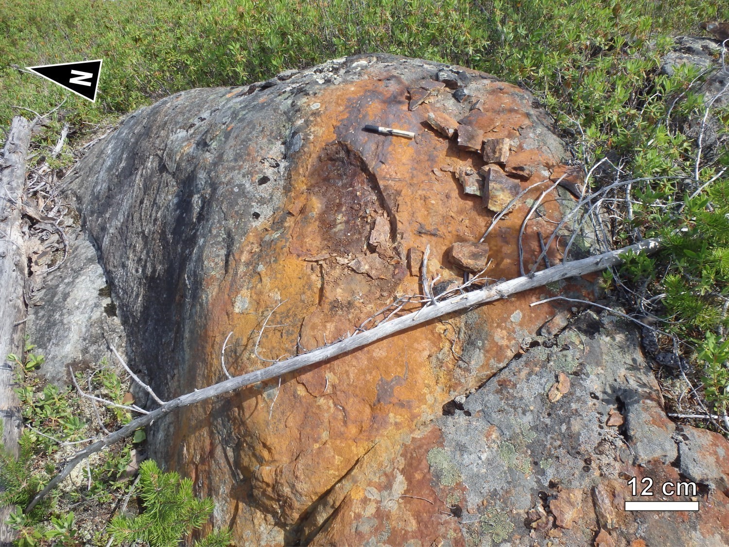
1) Exhalative stratiform volcanogenic mineralization: Dejour-NE (up to 3.4 g/t Au) and Lac Dolent (up to 4096 ppm Zn) mineralized zones, which are at the same stratigraphic level, are described as disseminated, semi-massive or massive volcanogenic sulphide mineralization associated with a conductive exhalative layer. The Dejour-NE mineralized zone (outcrop 18-FM-2111) exhibits sulphidic chert layers oriented parallel to regional foliation. Mineralized layers are hosted in silicified basalt and contain up to 15% pyrite, pyrrhotite and trace chalcopyrite. Work by the Ministère in the summer of 2018 strengthened the area’s potential for this type of metallogenic context by identifying thin stratiform exhalative layers of semi-massive to massive sulphides (outcrops 18-AB-1026, 18-MP-5036, 18-MP-5121 and 18-PG-4088). These layers conformable to stratigraphy are mostly associated with ultramafic rocks of the Dolent Formation. They are locally in contact with a thin strip of felsic tuff and are composed of 30-80% sulphides (pyrrhotite-pyrite ± sphalerite ± chalcopyrite).
2) Orogenic lode gold mineralization: Exko Showing, Exko Extension-NE and Dejour-SW mineralized zones are described as orogenic gold mineralization. At the Exko Showing site, mineralization is hosted in a quartz-pyrrhotite-pyrite vein hosted in actinolite schist. The schist layer is at the contact between basalt and ultramafic rocks of the Dolent Formation. Contents of up to 3.55 g/t Au and 5.25 g/t Au were obtained respectively from selected samples (Beesley, 1989) and in a drill core (Tremblay, 1994b). A conductive zone, which is also expressed by a strong EM anomaly, passes through the Exko zone and extends in an ENE direction up to ~2.5 km to the NE of the mineralized zone. Anomalous gold values were obtained on outcrops over a distance of ~200 m along the axis containing the Exko mineralized zone (Tremblay, 1994a). The Exko Extension-NE and Dejour-SW sites were discovered by drilling (Tremblay, 1995) and gold mineralization described are hosted in quartz-carbonate veins that cut altered and sheared pyroxenite or fractured basalt. The sulphide content (pyrite-pyrrhotite) ranges from 15% to 25% in the veins of these zones (Tremblay, 1995).
3) Lode gold mineralization in iron formations: Éch. Q17029 mineralized zone (up to 1.57 g/t Au) is described as mineralization hosted in silicate facies iron formation beds that are located at the contact between mafic and ultramafic volcanic rocks of the Dolent Formation (Dobbelsteyn and Frappier-Rivard, 2015). This zone was not visited during the Ministère's work.
Although gold mineralization of the UEGB are associated with different types of mineralization, one common feature is that they are all close to contact with an ultramafic sill or flow. For example, within the Dolent Formation, the two main ultramafic rock layers associated with shear zones are significant exploration guides. The first layer, north of the UEGB, consists of a differentiated mafic-ultramafic sill (nAdln3) and extends over >20 km laterally. Further south, unit nAdln4, which consists of a volcanic layer and an ultramafic sill, was also mapped. It is in sheared contact with highly deformed polymictic conglomerates of the Bohier Group.
The superposition of two mineralized systems (syngenetic volcanogenic and orogenic lode) appears to contribute to the gold potential of this prospective zone, as described in the former Eastmain Mine area (Beauchamp and Massei, 2017). Indeed, in the study area, the emplacement of exhalative and iron formation layers occurred near ultramafic rocks of the UEGB. These stratiform layers that mark a pause in volcanism are prospective for volcanogenic mineralization rich in Cu, Zn, Pb, Ag and Au. Subsequently, the development of structurally controlled epigenetic gold mineralization was superimposed on the exhalative systems. Orogenic-type lode gold developed in the UEGB, preferably in shear zones and in silicified lithological contacts. This spatial association between gold mineralization and sheared ultramafic horizons in the UEGB was also documented at the Timmins Mine camp (Fyon et al., 1983; Pyke, 1975). Finally, the identification of demagnetized zones in ultramafic layers is of particular interest since they are interpreted as areas where magnetite has been destroyed by alteration (Dobbelsteyn and Frappier-Rivard, 2015).
Spodumene Discovered in Pegmatite of the Wahemen Suite

The discovery of a lithium mineralization zone (Éch. S894341, 2.19% Li) in 2016 by Eastmain Resources (Frappier-Rivard, 2017) has revealed a lithiniferous potential for the Cadieux Lake area. This zone was revisited in the summer of 2018 and new sampling confirmed showing values in Li (1.2% Li, 2.59% LiO2), Ta (1030 ppm Ta) and Be (483 ppm Be), as well as anomalous contents in Cs (7530 ppm Cs), Nb (217 ppm Nb) and Rb (1970 ppm Rb). Mineralization is hosted in a white pegmatite dyke containing spodumene, biotite, muscovite, masutomilite and beryl that is exposed over a 60 m by 25 m zone near the northern limit of the UEGB. Spodumene is concentrated in centimetric crystal clusters and represents up to 30% of pegmatite. The rock belongs to the Wahemen Suite, which consists of undeformed and highly evolved peraluminous granitic intrusions. The mineralized dyke appears to have intruded within a major structure, near contact between basalts and a mafic-ultramafic sill of the Dolent Formation (Frappier-Rivard, 2017), <1 km from the Digne Pluton. According to Cerny (1991), the presence of a conformable package of gabbroic and mafic volcanic host rocks provides a favourable context for the discovery of lithium pegmatite within <2 km of anorogenic granitic massifs.
New Klippes of Supracrustal Rocks Discovered
New klippes of supracrustal rocks were mapped on the northern part of sheet 33A02. These klippes of limited lateral extension are part of the Mabille Complex. This complex includes a basalt unit (outcrops 18-PG-4125 and 18-PG-4126) and a garnet amphibolite unit (outcrop 18-SG-7041). Lake-bottom sediment anomalies were identified in the vicinity of these units (Solgadi, 2017) and delimited the Mabille-1 and Mabille-2 prospective zones. In the Mabille-1 zone, the highest value is 68.1 ppm Cu. The residual value calculated from the multiple spatial regression method is 28.5 ppm Cu, which places it in the 99th percentile rank of the survey. In the Mabille-2 zone, the most significant anomalous values are 223 ppm Cu, 38.9 ppm Ni and 188 ppm Zn. Residual values calculated from the multiple spatial regression method are 164 ppm Cu, 7.81 ppm Ni and 10.9 ppm Zn, respectively, which place them between 90th and 100th percentile in the survey. These new klippes of supracrustal rocks associated with lake bottom anomalies may indicate the proximity of base metal mineralization. However, no mineralization was identified during the Ministère's mapping campaign of 2018.
Discussion and Conclusions
The Ministère's mapping project allowed for a major stratigraphic, structural and metallogenic revision in the Cadieux Lake area. The main contributions of this project are as follows:
- The precision of the contact between the Opatica and Opinaca subprovinces;
- The identification of a Mesoarchean to Neoarchean TTG-type basement (Misasque Complex, Digne Pluton) located north of the UEGB western branch. The Chiyaaskw Pluton, exposed to the east of the study area (BG 2018-02), also appears to be a polyphased TTG-type basement;
- The stratigraphic positioning of the Dolent Formation within the René Group. The Dolent Formation, dated 2751 ±5 Ma (Davis, 2019) is younger than the Érasme and Roman formations. It may or may not be contemporaneous with the Clément Formation, which is located in the UEGB southern branch;
- The recognition of the MacLeod Batholith which was not present on previous maps produced by the Ministère (Hocq, 1976; Hocq, 1985; Couture, 1987). The Macleod Batholith has significant metallogenic significance in the region. In fact, several Cu-Mo-Ag-Au-W mineralized zones are found within the batholith or on its periphery, in metasedimentary rocks of the Laguiche Complex. Work in the summer of 2018 led to the discovery of a new silver mineralized zone (Cornu deposit) hosted in the Macleod Batholith <700 m from the contact with metasedimentary rocks;
- The designation of ultramafic units of the Dolent Formation as prospective marker layers for orogenic and exhalative volcanogenic gold mineralization in the UEGB.
Despite efforts to understand, some issues remain to be addressed. Among these are the following:
- The origin of rocks of the Maingault Complex and Mabille Complex and their belonging to the Opatica Subprovince is still uncertain. Mapping of adjacent sheets and geochronology will probably allow verifying whether these rocks are intrusive in the Laguiche Complex, or whether they represent rocks of the Opatica Subprovince exposed by a structural window within the Opinaca Basin.
- The tectonic process that led to the current arrangement of lithological units remains debatable. Although several models are conceivable, the one associated with the development of a vast diapiric dome, involving vertical movements prior to regional N-S compression, is favoured. Interpretation based on all field observations could look like this:
- The first Dn-1 deformation phase led to the development of domes exposing plutonic rocks and synclines preserving volcano-sedimentary sequences. In the Cadieux Lake area, exhumation of the Misasque Complex and Digne Pluton within a dome led to early folding of the overlying Dolent Formation. Vertical movements during Dn-1 were also accommodated by shear zones located at the interface between the domes' gneisso-plutonic packages and the synclines' supracrustal units (e.g. the Digne Shear Zone).
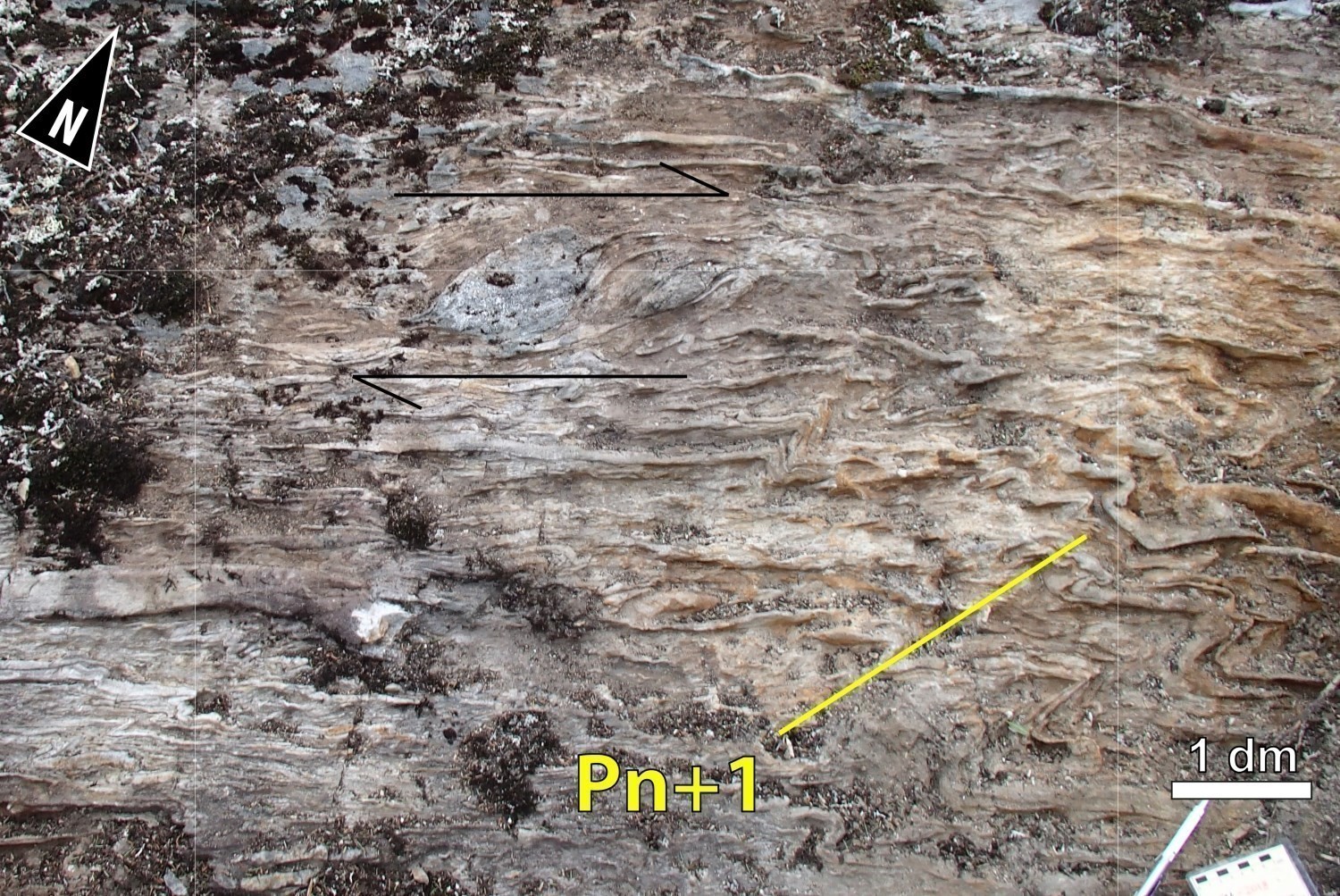
- Subsequently, during Dn deformation phase, an episode of NNW-SSE shortening prolonged the subsidence of the supracrustal sequence in an ENE-WSW syncline, which is occupied by the Bohier Group. At the edge of this basin, ENE-WSW shear zones contributed to the burial of supracrustal rocks. However, NNW-SSE shortening also results in lateral creep of deeper crustal domains, such as the Misasque dome. This creep would have, on the one hand, led to the parallelization of Pn-1 fold axes as well as mineral and Ln stretch lineations in a NE plunging direction and, on the other hand, led to the overturning of the lithostratigraphic pile at the SW termination of the Misasque dome (see interpretative model).
- Finally, Dn+1 deformation repeated previous fabrics, but this could represent a late increment of Dn phase.
Whatever the structural model considered, it must imperatively respect field observations which indicate that supracrustal rocks are overturned, and that they are geometrically associated with the periphery of large intrusive masses.
| Authors | Anne-Marie Beauchamp, Eng., M.Sc., anne-marie.beauchamp@mern.gouv.qc.ca |
| Geochemistry | Fabien Solgadi, P.Geo., Ph.D. |
| Geophysics | Siham Benhamed, GIT, M.Sc. Rachid Intissar, P.Geo., M.Sc. |
| Potential assessment | Hanafi Hammouche, P.Geo., M.Sc. |
| Logistics | Marie Dussault |
| Geomatics |
Karine Allard |
| Template and content compliance | François Leclerc, P.Geo., Ph.D. |
| Coaching/mentoring and critical review | Patrice Roy, P.Geo., M.Sc. |
| English version | Céline Dupuis, P.Geo., Ph.D. |
| Organism | General Direction of Géologie Québec, Ministère de l'Énergie et des Ressources naturelles, Government of Québec |
Acknowledgements:
This Geological Bulletin was made possible through the cooperation of many people who actively took part in the various stages of the project. The author would like to thank geologists Frédéric Massei (co-leader), William Chartier-Montreuil, Sarah Galloway, Pierre-Arthur Groulier, Lynda Paquette and Martin Parent, as well as students Nicolas Benoit, Laurence Bourque, Ève Gosselin, Ola Grignon, Alexandra Harvey, Simon Hector, Guillaume Thériault. We would like to acknowledge the excellent work of camp man Daniel Gosselin. We thank the Mistay company for camp rental. Field transportation was provided by Heli-express. Discussions with Patrice Roy (MERN), Yannick Daoudene (MERN), James Moorhead (MERN), Stéphane de Souza (UQAM), Myriam Côté-Roberge (MERN) and Jean Goutier (MERN) were also very beneficial.
References
Publications Available Through Sigéom Examine
BEAUCHAMP, A.-M., MASSEI, F., DAOUDENE, Y., 2018. Géologie de la région de l'île Bohier, au contact entre les sous-provinces d'Opatica, d'Opinaca et le bassin d'Otish, au nord de Mistissini, Eeyou Istchee Baie-James, Québec, Canada. MERN; BG 2018-02, 1 plan.
BEESLEY, T.J., 1989. REPORT ON 1989 Summer field season, Eastmain river greenstone belt. Quill Resources Ltd, Eastmain River Syndicate. QUILL RESOURCES LTD, EASTMAIN RIVER SYNDICATE, Assessment report submitted to the Government of Québec; GM 49478, 31 pages and 28 plans.
BEESLEY, T.J., ENGELEN, J.V., 1989. Report on gold exploration during the 1988 summer field season, Eastmain River greenstone belt. Quill Resources Ltd, Claim Dallaire, Assessment report submitted to the Government of Québec; GM 48783, 112 pages and 23 plans.
BYRON, M.J., CLARK, R.D., 1999. Geology of the Eastmain river zinc property. Windy Mountain Expls Ltd., Assessment report submitted to the Government of Québec; GM 57400, 26 pages and 1 plan.
CÔTÉ-ROBERGE, M., GUILMETTE, C., GOUTIER, J., 2018. Chimie minérale et thermobarométrie : étude du contexte tectono-métamorphique du Complexe de Laguiche, Sous-province d'Opinaca, Eeyou Istchee Baie-James. Université Laval, MERN. MB 2018-03, 146 pages.
COUTURE, J.F., 1987. Géologie de la partie occidentale de la bande volcanosédimentaire de la rivière Eastmain supérieure - rapport intérimaire. MRN. MB 87-51, 111 pages.
D'AMOURS, I., 2011. Synthèses des levés magnétiques de la Baie-James. MRNF. DP 2011-08, 5 pages and 2 plans.
Davis, D.W., SUTCLIFFE, C.N., 2018a. U-Pb Geochronology of Zircon and Monazite by LA-ICPMS in samples from northern Quebec. University of Toronto. MB 2018-18, 54 pages.
DAVIS, D.W., SUTCLIFFE, C.N., 2018b. U-Pb Geochronology of Zircon and Monazite by LA-ICPMS in Samples from Northern Quebec. University of Toronto. MB 2019-01, 113 pages.
DAVIS, D.W., LAFRANCE, I., GOUTIER, J., BANDYAYERA, D., TALLA TAKAM, F., GIGON, J., 2018c. Datations dans les provinces du Churchill et du Supérieur effectuées au JSGL en 2013-2014. MERN. RP 2017-01, 63 pages.
DAVIS, D.W., 2019. Rapport sur les datations U-Pb de roches du Québec 2018-2019, projets Lac Cadieux et Lac Watts. UNIVERSITY OF TORONTO. MB 2019-09, 82 pages.
DOBBELSTEYN, G., FRAPPIER RIVARD, D., 2015. Report on exploration activities 2014, Ruby Hill west project. Eastmain Resources Inc. Assessment report submitted to the Government of Québec. GM 69066, 128 pages and 4 plans.
FRAPPIER-RIVARD, D., 2017. Report on exploration activities 2016, Ruby Hill west project. EASTMAIN RESOURCES INC. Assessment report submitted to the Government of Québec. GM 70636, 90 pages and 1 plan.
GIGON, J., GOUTIER, J., 2017. Géologie de la région du lac Richardie, municipalité d'Eeyou Istchee Baie-James. MERN. RG 2016-04, 45 pages and 2 plans.
HAMILTON, M.A., 2009. Datation isotopique (U-Pb) d'une diabase de l'essaim de dykes Mistassini, Quebec - U-Pb isotopic of a diabase dyke of the Mistassini swarm, Quebec. University of Toronto, Jack Satterly Geochronology Laboratory. MB 2009-17, 13 pages.
HOCQ, M., 1976. Géologie de la région du lac Cadieux (Nouveau-Québec). MRN. DPV 433, 19 pages and 1 plan.
HOCQ, M., 1985. Géologie de la région des lacs Campan et Cadieux, Territoire-du-Nouveau-Québec. MRN. ET 83-05, 190 pages and 4 plans.
JEBRAK, M., MARCOUX, E., 2008. Géologie des ressources minérales. MRNF; MM 2008-01, 672 pages.
LEBLANC, G., KENDLE, F., 2009. Technical report on exploration activities in 2008, Ruby Hill project. Ruby Hill Exploration Inc, Eastmain Resources Inc. Assessment report submitted to the Government of Québec. GM 64602, 1143 pages and 30 plans.
PILKEY, D., 1990a. Geological report, MacLeod Lake property (new claim block). Windy Mountain Expls Ltd. Assessment report submitted to the Government of Québec. GM 51083, 47 pages and 5 plans.
PILKEY, D., 1990b. Geological report, MacLeod Lake property (new claim block). Windy Mountain Expls Ltd. Assessment report submitted to the Government of Québec. GM 51330, 47 pages and 5 plans.
PRIOR, G. J., 1991. PRELIMINARY REPORT ON RECONNAISSANCE GEOLOGICAL MAPPING AND PROSPECTING, EASTMAIN RIVER PROJECT. WINDY MOUNTAIN EXPLS LTD, COCHISE RESOURCES INC, assessment work submitted to the Government of Québec. GM 50827, 99 pages, 13 maps.
RHÉAUME OUELLET, A., GUILMETTE, C., 2016. Chimie minérale d'échantillons des sous-povinces d'Opinaca et de La Grande ([33G06, 33H08, 33H01]. Université Laval. MB 2016-15, 39 pages.
ROY, C., 1988. Géologie du secteur de l'île Bohier de la bande volcanosédimentaire de la rivière Eastmain supérieure. MRN. MB 88-16, 115 pages and 5 plans.
SOLGADI, F., 2017. Nouveau levé géochimique de sédiments de fond de lac dans le secteur Mistassini Nord, Province du Supérieur, Québec. MERN. DP 2017-09, 15 pages and 16 plans.
ST-HILAIRE, C., 2008. Final technical report, heliborne high resolution aeromagnetic and spectrometric survey, McLeod Lake, McLeod infill, east and west blocks. Ressources Melkior Inc. Assessment report submitted to the Government of Québec. GM 64110, 37 pages and 21 plans.
TALLA TAKAM, F., BEAUCHAMP, A.-M., MASSEI, F., en préparation. Levé géologique au nord-est de Mistissini, à la limite entre les sous-provinces de La Grande, d’Opinaca et d’Opatica, Eeyou Istchee Baie-James [régions du lac Emmanuel et du lac Léran], Ministère de l'Énergie et des Ressources naturelles, Québec.
TREMBLAY, A., 1994a. Programme d'exploration 1994, projet Eastmain. Southern Africa minerals corporation. Assessment report submitted to the Government of Québec. GM 53606, 136 pages and 17 plans.
TREMBLAY, A., 1994b. Programme d'exploration, projet Eastmain. Géonova Explorations Inc, Dejour Mines Ltd. Assessment report submitted to the Government of Québec. GM 55030, 136 pages and 17 plans.
TREMBLAY, A., 1995. Campagne de sondage, hiver 1995, projet Eastmain. Dejour Mines Ltd, South Africa minerals Corp, Géonova Explorations Inc. Assessment report submitted to the Government of Québec. GM 53600, 241 pages and 16 plans.
TRUDEL, D., 1997. Rapport de campagne, propriété Eastmain. Géonova Explorations Inc, Dejour Mines Ltd. Assessment report submitted to the Government of Québec. GM 55591, 138 pages and 12 plans.
WADE, T., COCIORBA, T., LEGAULT, J., PLASTOW, G., 2014. Report on 3-axis helicopter-borne magnetic gradiometer geophysical survey, Ruby Hill west block. Eastmain Resources Inc. Assessment report submitted to the Government of Québec. GM 68338, 40 pages and 36 plans.
WINTER, L.D.S., 1989. Geological report on the MacLeod Lake property, lac Autric area. Claim Brack, Windy Mountain Expls Ltd, Claim Canova. Assessment report submitted to the Government of Québec. GM 48881, 35 pages and 3 plans.
WINTER, L.D.S., 1992. Summary report MacLeod Lake claim group and Eastmain river licences of exploration. Windy Mountain Expls Ltd, Cochise Resources Inc. Assessment report submitted to the Government of Québec. GM 58050, 85 pages and 3 plans.
WINTER, L.D.S., 2007. Report on the diamond drilling program, Windy 2 claim group, MacLeod Lake property. Western Troy Capital Resources. Assessment report submitted to the Government of Québec. GM 63277, 40 pages.
WINTER, L.D.S., FILICE, R. 2007. Report on the diamond drilling programs, MacLeod Lake property. Western Troy Capital Resources, Match Capital Resources Corporation. Assessment report submitted to the Government of Québec. GM 63215, 342 pages.
WINTER, L.D.S., 2008. Drilling program report, MacLeod Lake property. Western Troy Capital Resources. Assessment report submitted to the Government of Québec. GM 63812, 499 pages.
Other Publications
BUCHAN, K.L., MORTENSEN, J.K., CARD, K.D., 1993. Northeast-trending Early Proterozoic dykes of the southern Superior Province: multiple episodes of emplacement recognized from integrated paleomagnetism and U-Pb geochronology. Canadian Journal of Earth Sciences; volume 30, pages 1286-1296. doi.org/10.1139/e93-110
BUCHER, K., GRAPES, R., 2011. Petrogenesis of Metamorphic Rocks. Springer-Verlag Berlin Heidelberg; édition 8, 428 pages.
CARD, K.D., CIESIELSKI, A., 1986. Subdivisions of the Superior Province of the Canadian Shield. Geoscience Canada; volume 13, pages 5-13. Source
CERNY, P., 1991. Rare elements in granitic pegmatites, Part I; anatomy and internal evolution of pegmatite deposits. Geoscience Canada; volume 18, pages 49-67. Source
COOK, R.B., COX, J.J., PRESSACCO, R., SCOTT, K.C., 2008. Preliminary Assessment of the MacLeod Lake Project, Quebec, Canada, préparé pour Western Troy Capital Resources Inc.. NI 43-101 Report, Scoot Wilson Roscoe Postle Associates Inc.; 231 pages, 48 tableaux and 52 plans.
FYON, J.A., CROCKET, J.H., SCHWARCZ, H.P., 1983. Magnesite abundance as a guide to gold mineralization associated with ultramafic flows, Timmins area. Journal of Geochemical Exploration; volume 18, pages 245-266. doi.org/10.1016/0375-6742[83] 90071-7
MORFIN, S., SAWYER, E. W., BANDYAYERA, D., 2013. Large volumes of anatectic melt retained in granulite facies migmatites: An injection complex in northern Quebec. Lithos; 168-169, pages 200-218. doi.org/10.1016/j.lithos.2013.02.007
PYKE, D.R., 1975. On the relationship of gold mineralization and ultramafic volcanic rocks in the Timmins area. Ontario Div. Mines; MP62, 23 pages.
RAMSAY, J.G., 1962. Interference Patterns Produced by the Superposition of Folds of Similar Type. The Journal of Geology; volume 70, numéro 4, pages 466-481. doi.org/10.1086/626837
WINTER, D.W., 2010. Principles of Igneous and Metamorphic Petrology, 2nd Edition. Prentice Hall; 702 pages.
WINTER, L.D.S., 2011. Technical report NI 43-101 for the MacLeod Lake property, Chibougamau mining district, Quebec, préparé pour Western Troy Capital Resources Inc., NI 43-101 Report; 74 pages.
BEAUCHAMP, A.-M., 2019. Geology of the Cadieux Lake Area, Opatica and Opinaca Subprovinces, Eeyou Istchee James Bay, Quebec, Canada. MRNF; BG 2019-02, 2 plans.