

Last modification:
| Author(s) | Beauchamp, 2019 |
| Methodology | Defined from geological survey and geophysical data |
| Geological(s) subdivision(s) | Superior Province / Opatica Subprovince |
| Main movement | Reverse |
| Deformation style | Homogeneous |
| Metamorphic facies (mean facies related to main deformation) | Undetermined |
Background and Methodology
The Digne Shear Zone was defined by Beauchamp (2019) following a mapping survey conducted in the Cadieux Lake area in the summer of 2018. It is located at the contact between intrusive and volcanic rocks of the Dolent Formation, which is part of the Upper Eastmain Greenstone Belt (UEGB), to the south, and the Digne Pluton, to the north. It is described using geological observations collected by Beauchamp (2019) and Beauchamp et al. (2018), and using analysis of geophysical imagery (total magnetic field and vertical gradient) from the SIGÉOM and detailed magnetic maps by Wade et al., 2014.
Boundaries and Morphology
| Width | Undetermined. The deformation zone appears to be relatively small in width (<1 km). |
| Length | About forty kilometres in sheets 33A07-33A08. |
| Orientation | ENE-WSW |
Stratigraphic Units Concerned
The only unit affected by the Digne Shear Zone is the Digne Pluton.
Structural Characteristics
❯ Main Fabrics
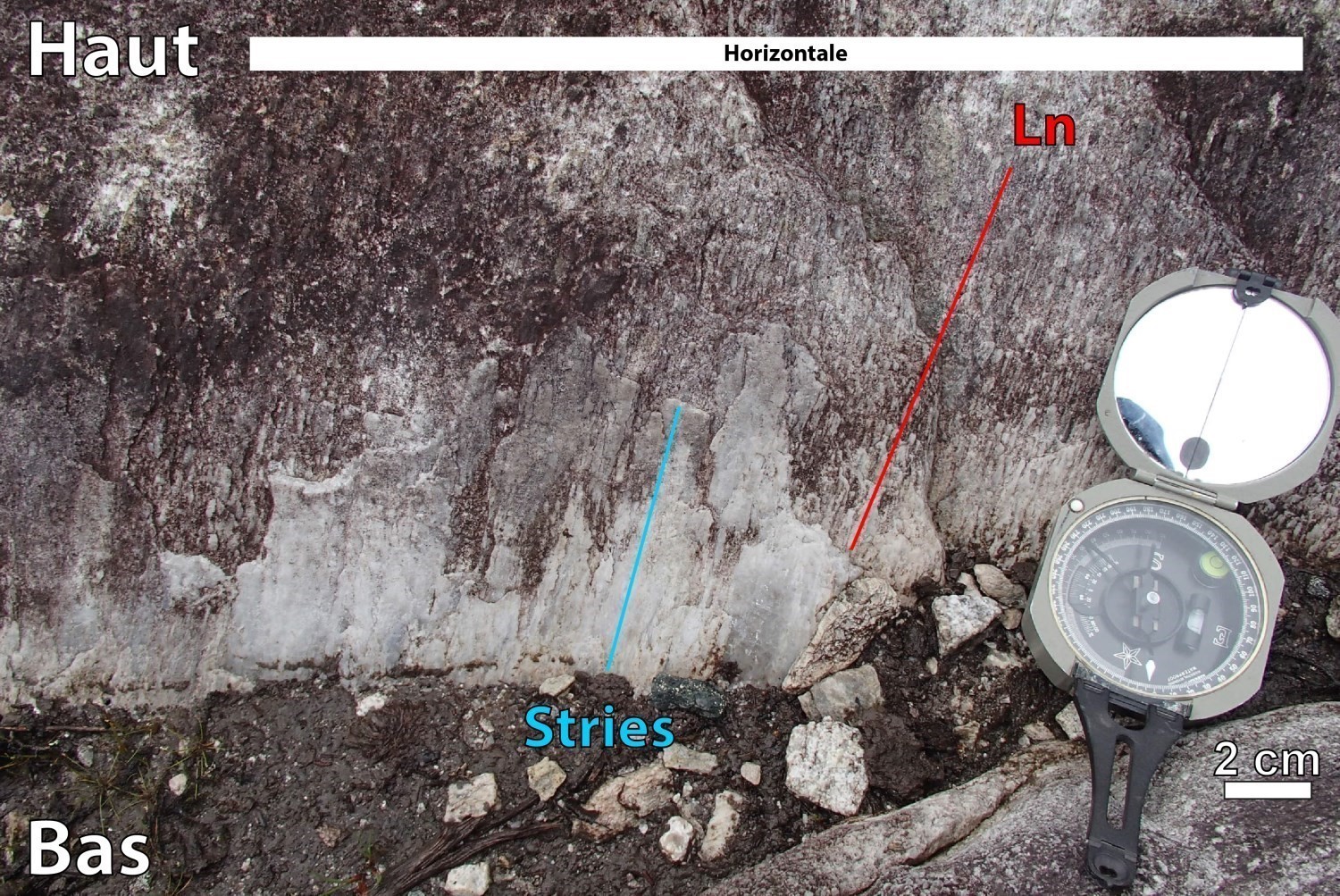
In the Structural Lexicon, the dominant fabric of a domain is, by definition, associated with the Dn phase. Earlier phases are referred to as Dn-1, Dn-2, etc. and later phases as Dn+1, Dn+2, etc. The Dn phase of a domain does not therefore necessarily correspond to that of neighbouring domains. The planar fabric (Sn), which is best expressed in the Digne Shear Zone, corresponds to regional fabric S1. It predates the main regional fabric that is generally observed on outcrops in the Cadieux Lake and Bohier Island areas (Sn=S2).
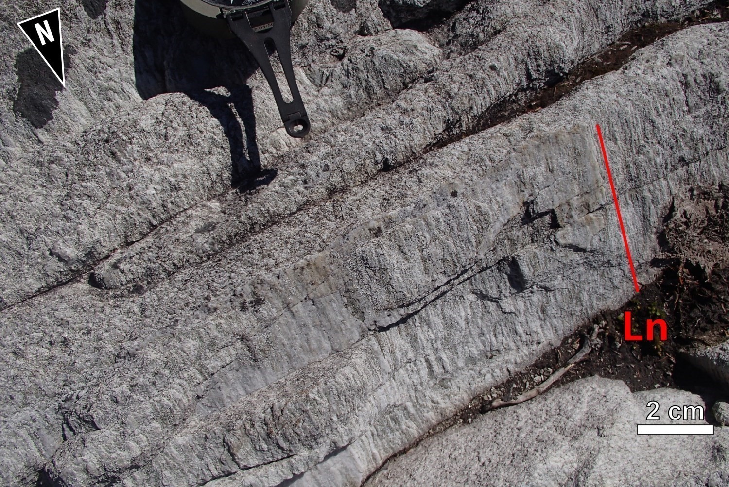
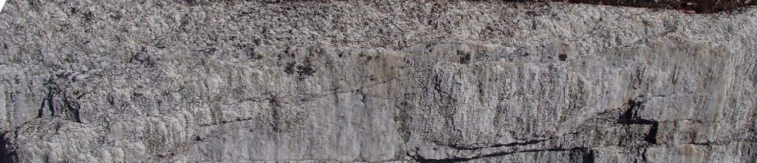
 The main fabric of the Digne Shear Zone is stretch lineation Ln. Rocks of the Digne Pluton, which are in contact with the UEGB, form L>> S tectonites. Lineation is defined by very pronounced stretching of quartz and feldspar grains until bands are formed. A planar fabric is locally observed, especially as one moves northwards away from the Digne shear zone. The Sn planar fabric is weakly to moderately developed and is distinguished by the millimetric spacing of flattening planes. Phyllosilicates (biotite, chlorite and muscovite) are oriented in Sn foliation planes.
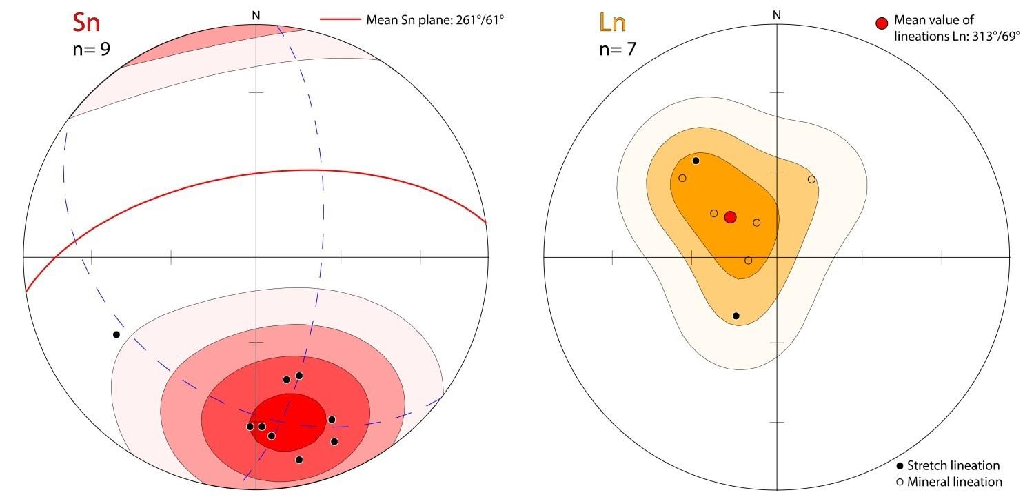
| Main Fabric | Type of Fabric | Direction (°) | Dip / Plunge (°) | Number of Measurements |
| Foliation Sn | Foliation and penetrative schistosity | 261 | 61 | 9 |
| Lineation Ln | Mineral and stretch lineations | 313 | 69 | 7 |
❯ Other Fabrics
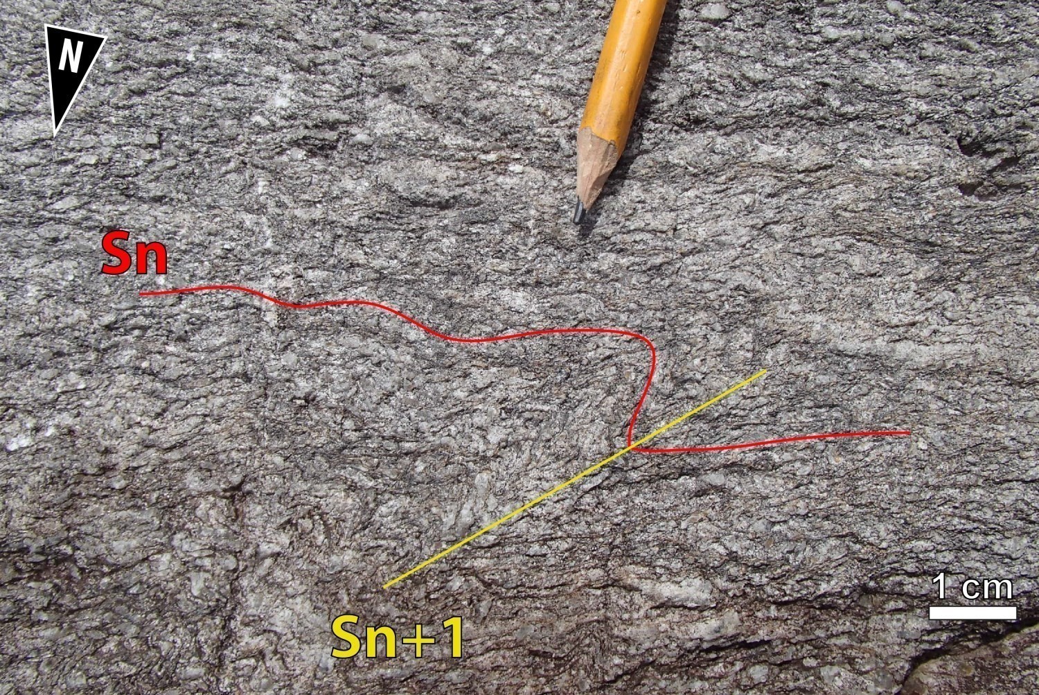 Outcrop 18-AB-1085 clearly displays two fabrics. Foliation Sn is oriented E-W and dips moderately northwards. In thin sections, a NNE-SSW oriented crenulation cleavage Sn+1 folds the Sn fabric.
❯ Folds
As shown on the geological map of the Cadieux Lake area, the CSdig is folded by a succession of regional ENE-WSW folds (Pn+1) which axes plunge slightly to moderately towards the ENE. On outcrops, a few occurrences of Pn+1 folds having NNE-SSW axial planes parallel to crenulation Sn+1 are found.
❯ Crosscutting Relationships
The existence of very detailed magnetic maps of the Digne Shear Zone (Wade et al., 2014) has enabled mapping numerous brittle faults having steep dip. Two major families can be identified. A first family of NNW-SSE faults offsets shearing in a dextral manner. A second family of faults having sinistral movement has an orientation varying from NW-SE to WNW-ESE. These fractures also affect rocks of the Dolent Structural Domain (DSdol).
Geometric Parameters of Regional Faults Cutting the Digne Shear Zone:
| Fault or Family of Faults | Type | Mean Direction (°) | Mean Dip (°) | Lineation Plunge in the Fault Plane | Estimated Width (m) | Estimated Length (km) | Apparent Movement | Position | Comments |
| Family of faults | Faults | NNW-SSE | ~80° | Unknown | <1 | >1 | Dextral | Certain and probable | These same faults affect the DSdol. |
| Family of faults | Faults | NW-SE - WNW-ESE | ~80° | Unknown | <1 | >1 | Sinistral | Ceratian and probable | These same faults affect the DSdol. |
❯ Kinematics

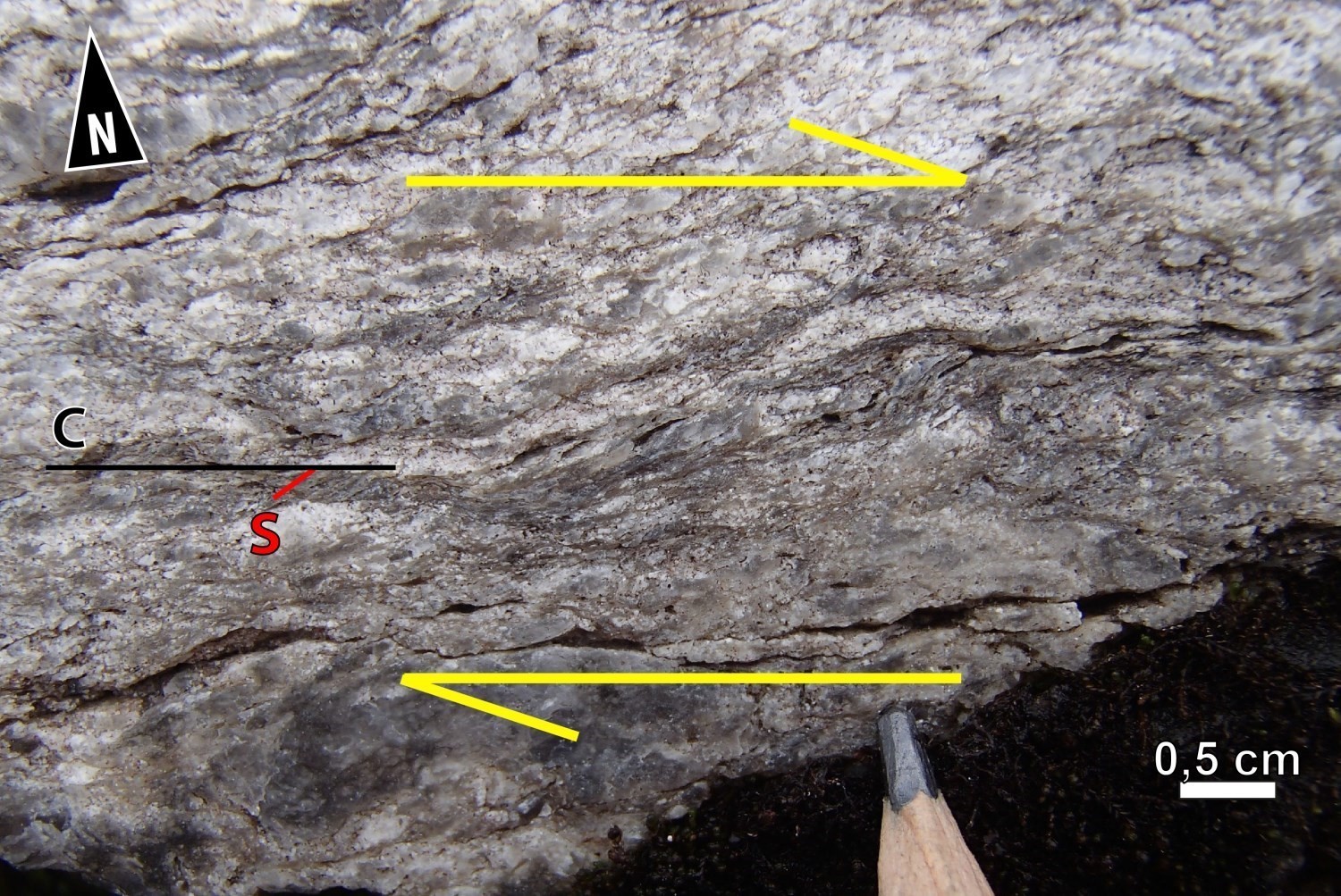
Kinematic indicators observed in the field reveal that the Digne Shear Zone was displaced in reverse movement. These kinematic indicators are:
- sigmoids and C/S fabrics indicating reverse movement in L-S tectonites of the Digne Pluton (outcrops 18-AB-1085, 18-AB-1027 and 18-AB-1033);
- fault striations indicating reverse movement (outcrop 18-AB-1085);
- protomylonitic textures (C/S fabrics) indicating apparent dextral movement (outcrop 18-LP-6198, 18-MP-5045 and 18-AB-1085).
| Type | Direction (°) (Mean) | Dip(°) (Mean) | Lineation Plunge in the Fault Plane | Apparent Movement | Kinematic Indicators | Comments |
| Shear | 261 | 61 | Mean lineation measured in the field: 313°/69° | Reverse | Sigma-type porphyroclasts, C/S fabric and fault striations |
Deformation Style
The CSdig is a straight to curvilinear, homogeneous and well-defined shear zone. It is characterized by the presence of L>>S tectonites. Deformation is mainly in the constriction domain. The very pronounced stretch lineation (313°/69°), which corresponds to the X-axis on the ellipsoid of the finished deformation (Flinn, 1965), indicates the main direction of tectonic transport of the rocks. This significant ductile deformation could possibly be caused by gravitational sinking of greenstones beneath granitoids of the Digne Pluton or by thrusting of the Digne Pluton over UEGB rocks.
Metamorphic Characteristics
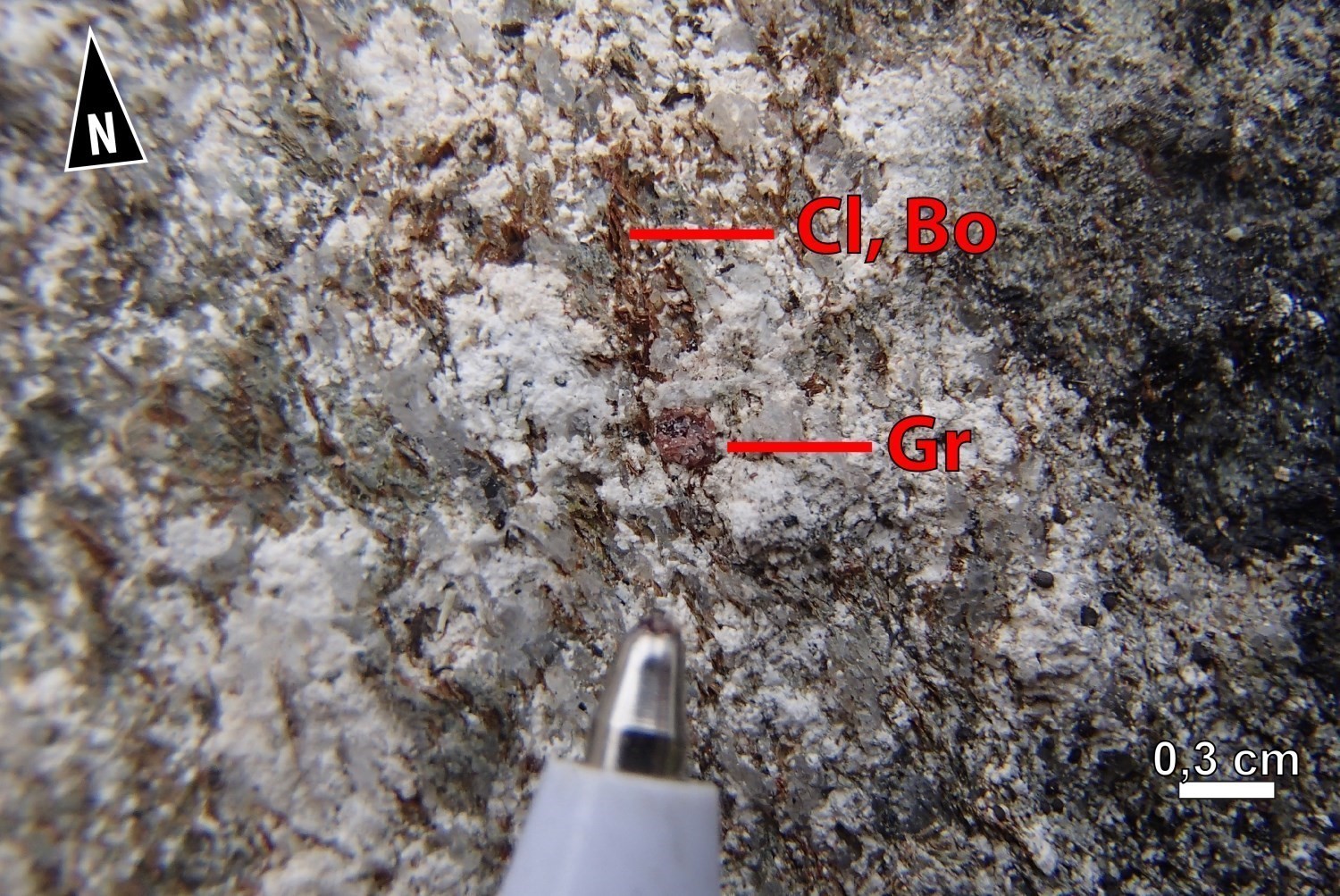
Rocks of the Digne Pluton contain quartz-plagioclase-biotite ± chlorite ± muscovite ± garnet assemblages. The metamorphic facies reached along the CSdig cannot be determined. It is most probably similar to that reached in the UEGB, i.e. the amphibolite facies.
Alterations
Alterations observed along the CSdig are muscovitization, chloritization and albitization. The absence of outcrops in the deformation zone does not allow the distribution and intensity of alteration to be documented.
Geophysical Characteristics
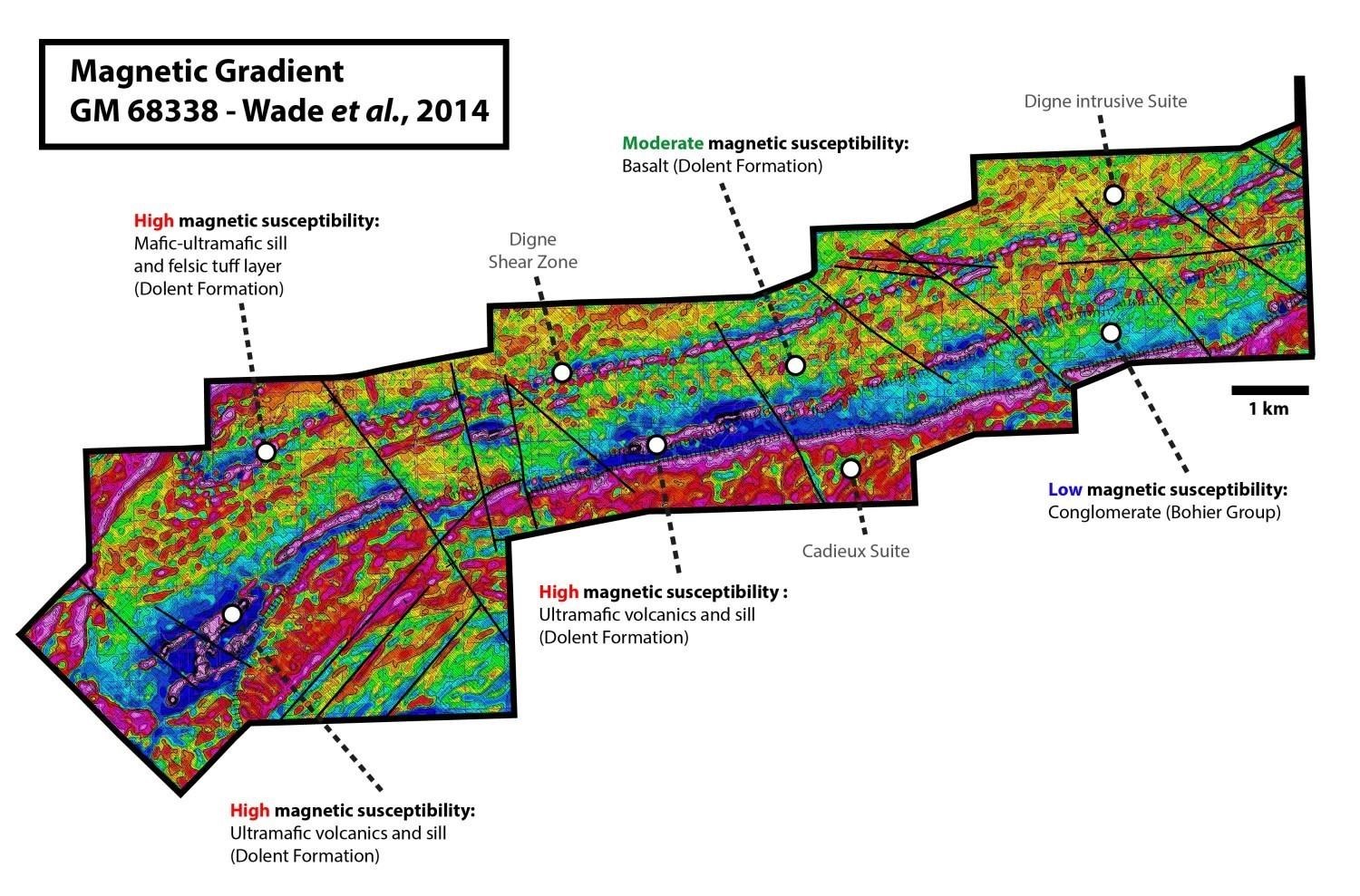 The CSdig is defined by a straight to curvilinear lineament of low magnetic susceptibility. It is located directly north of the mafic-ultramafic sill of the Dolent Formation (nAdln3), which is characterized by very high magnetic susceptibility.
Chronological Markers
The Digne Shear Zone marks the contact between rocks of the Dolent Formation (2751 ±5 Ma; Davis, 2019), which represent the remains of a supracrustal cover, and Mesoarchean bedrock, the Digne Pluton (2814 ±7 Ma; Davis, 2019). Sinking of greenstones beneath the Digne Pluton, or thrusting of the Digne Pluton on the Dolent Formation, occurred after 2751 ±5 Ma (age of the Dolent Formation). This may have occurred during a deformation phase prior to regional N-S compression that generated the main fabric of the entire Eeyou Istchee James Bay region.
References
Publications Available Through Sigéom Examine
BEAUCHAMP, A M. 2019. Géologie de la région du lac Cadieux, sous-provinces d’Opatica et d’Opinaca, Eeyou Istchee Baie-James, Québec, Canada. MERN. BG 2019-02, 1 plan.
DAVIS, D. W., 2019. Rapport sur les datations U-Pb de roches du Québec 2018-2019, projets Lac Cadieux et Lac Watts. UNIVERSITY OF TORONTO; MB 2019-09, 82 pages.
WADE, T., COCIORBA, T., LEGAULT, J., PLASTOW, G. 2014. REPORT ON 3-AXIS HELICOPTER-BORNE MAGNETIC GRADIOMETER GEOPHYSICAL SURVEY, RUBY HILL WEST BLOCK. EASTMAIN RESOURCES INC. Assessment report sumitted to the Government of Québec. GM 68338, 40 pages and 36 plans.
Other Publications
FLINN, E.A., 1965. Signal Analysis Using Rectilinearity and Direction of Particle Motion. Proceedings of IEEE, volume 12, pages 1874-1876. doi.org/10.1109/PROC.1965.4462
Suggested Citation
Contributors
|
First publication |
Anne-Marie Beauchamp, P. Geo., M.Sc. anne-marie.beauchamp@mern.gouv.qc.ca (redaction) Ghyslain Roy, P. Geo. (coordination); Patrice Roy, P. Geo., Ph.D. (critical review); Simon Auclair, P. Geo., M.Sc. (editing); André Tremblay (HTML editing); Céline Dupuis, P. Geo., Ph.D. (English version) |