


Geology of The Bohier Island Region, Contact Between the Opatica and Opinaca Subprovinces and the Otish Basin, North of Mistissini, Eeyou Istchee James Bay, Quebec, Canada
Project for NTS sheets 23D04, 23D05, 33A01 and 33A08
Anne-Marie Beauchamp, Frédéric Massei and Yannick Daoudene
BG 2018-02
Translated on 20 November 2018


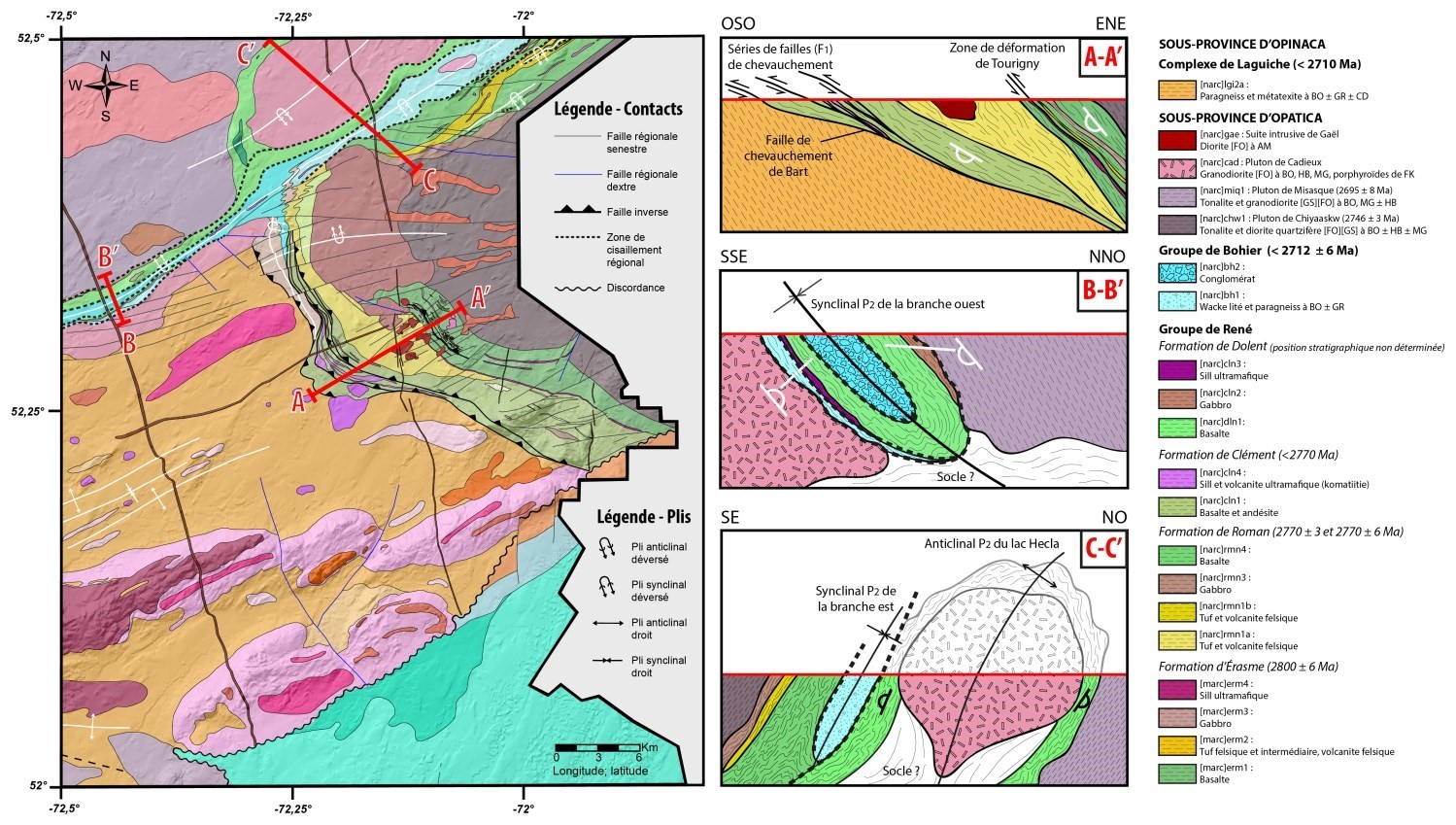
A new geological map of the Bohier Island region (Opatica and Opinaca subprovinces) was produced at a 1:50,000 scale following a survey conducted in summer 2017. Mapping of this area has allowed for an in-depth reinterpretation of the Upper Eastmain Greenstone Belt (UEGB) from a structural and stratigraphic perspective. Thus, volcanic rocks of the René Group were divided into four new formal units: the Érasme Formation, the Roman Formation, the Clément Formation and the Dolent Formation. Metasedimentary rocks of the Bohier Group are at the top of the stratigraphic pile. The unique four-branched shape of the belt is explained by the combined effect of polyphased deformation and synvolcanic and syntectonic intrusions at the heart of anticlinal domes.
The region was already known to be rich in mineralization and no new showings were uncovered as a result of the mapping work. However, the sampling done strengthens the sector's potential. For example, a Zn content of 1.78% was obtained from a semi-massive pyrite, pyrrhotite and sphalerite sulphide sample from the Château Fort Hill showing. Analysis of a tonalite cut by quartz-amphibole-chlorite-carbonate-pyrite-chalcopyrite veins from the Contact Est showing yielded a value of 5.29 g/t Au, increasing the potential for porphyry-type mineralizations in the Bohier Island Pluton. In addition, it is proposed to reconsider the Eastmain Mine deposit model and several showings of the area that would be volcanogenic rather than orogenic, which opens up new possibilities for exploration.
Methodology
The region was mapped using the established survey methodology in remote areas without road access. Geological mapping work was conducted by a team of six geologists and six students between June 6 and August 18, 2017.
Geological mapping of the Bohier Island area has produced and updated information presented in the table below:
| Elements | Number |
|---|---|
| Outcrops described (“geofiches”) | 1105 |
| Total lithogeochemical analyses | 339 |
| Lithogeochemical analyses of metals of economic interest | 66 |
| Geochronological analyses | 6 |
| Covered thin sections | 327 |
| Polished thin sections | 108 |
| Sodium cobaltinitrite stains | 101 |
| Stratigraphic units | 16 |
| Mineralization records | 36 |
Previous work
The table below provides a list and a short description of the work done since 1935 in the study area. Also included are the references cited in the report.
| Author(s) | Type of work | Contribution |
|---|---|---|
| Chown, 1969 | Geological survey | Geological context of the study area |
| Cartography | Geological maps of the study area | |
|
Boldy et al., 1984 |
Company report | Establishment of the belt stratigraphy and geological context |
| Hocq, 1985 | Cartographic synthesis | Maps and regional geology |
| Genest, 1989 | Ph.D. thesis | Study of the stratigraphy and sedimentology of the Otish Basin |
| Keech, 1983; Davidson et Fleming, 1983; Drouin et Thiboutot, 1983a, 1983b |
Geological and magnetic survey, drilling report | Exploration work in the study area |
| Madon, 1983 | Geological, scintillometric and spectrometric surveys | Exploration work in the study area |
| Drouin, 1983; Knowles et Thiboutot, 1988; Francoeur et Archer, 1995 |
Geological survey | Exploration work in the Eastmain Mine area |
| Hilgendorf, 1987 Chapdelaine, 1995 Tyson, 1997 Roy, 2005 |
Geological survey | Exploration work in the Harbour Lake area |
| Beesley, 1989 | Geological survey | Exploration work in the study area |
| Leblanc, 1997 | Geological and magnetic surveys, drilling report | Exploration work in the Eastmain Mine area |
| Trudel, 1997 | Geological and magnetic surveys, drilling report | Exploration work in the study area |
| Huss, 2002 | Compilation report | Compilation and geology of superficial deposits in the Otish Basin |
| Roby, 2008; Chevé, 2008 |
Geological, magnetic, scintillometric and spectrometric surveys | Exploration work in the study area |
| Lalancette et Girard, 2007; Lalancette et al., 2009; Lalancette et Girard, 2011; Desbiens et Desormeaux, 2012; Hebert et Archer, 2012; Desbiens, 2013; Theberge, 2014; Lacey, 2015 |
Geological survey | Exploration work in the study area |
| D'Amours, 2011 | Aeromagnetic survey | Complete coverage of the area with aeromagnetic surveys |
| Joly, 2012 | Geological and radiometric surveys | Exploration work in the study area |
| St-Hilaire, 2008, 2013; Dubé, 2015 |
Aeromagnetic survey | More precise aeromagnetic map of the volcanic belt |
| Dadson et Robinson, 2010; Gerber et Robinson, 2012; Dobbelsteyn et Frappier-Rivard, 2015a, 2015b; Frappier-Rivard, 2015 |
Geological survey | Exploration work in the Eastmain Mine area |
| Béland et al., 2013, 2015 | Geological and magnetic surveys, drilling report | New data in the Harbour Lake area |
Lithostratigraphy
The mapped area is located in the northeast part of the Opatica Subprovince and southeast part of the Opinaca Subprovince, southeast of the Superior Province. The Opatica Subprovince groups Mesoarchean to Neoarchean volcano-plutonic and gneissic units, while Opinaca represents an assemblage of metasedimentary rocks of Neoarchean age (Card and Cieselski, 1986). In the southeastern part of the mapped area, Paleoproterozoic sedimentary rocks from the Otish Basin unconformably overly rocks of these two Archean subprovinces. Neoarchean and Paleoproterozoic mafic dykes cut all or part of the region's stratigraphic units.
Units in the Bohier Island area can be divided into four (4) groups:
- units belonging to the Opatica Subprovince;
- units belonging to the Opinaca Subprovince;
- Neoarchean and Paleoproterozoic mafic dykes;
- sedimentary rocks of the Otish Basin.
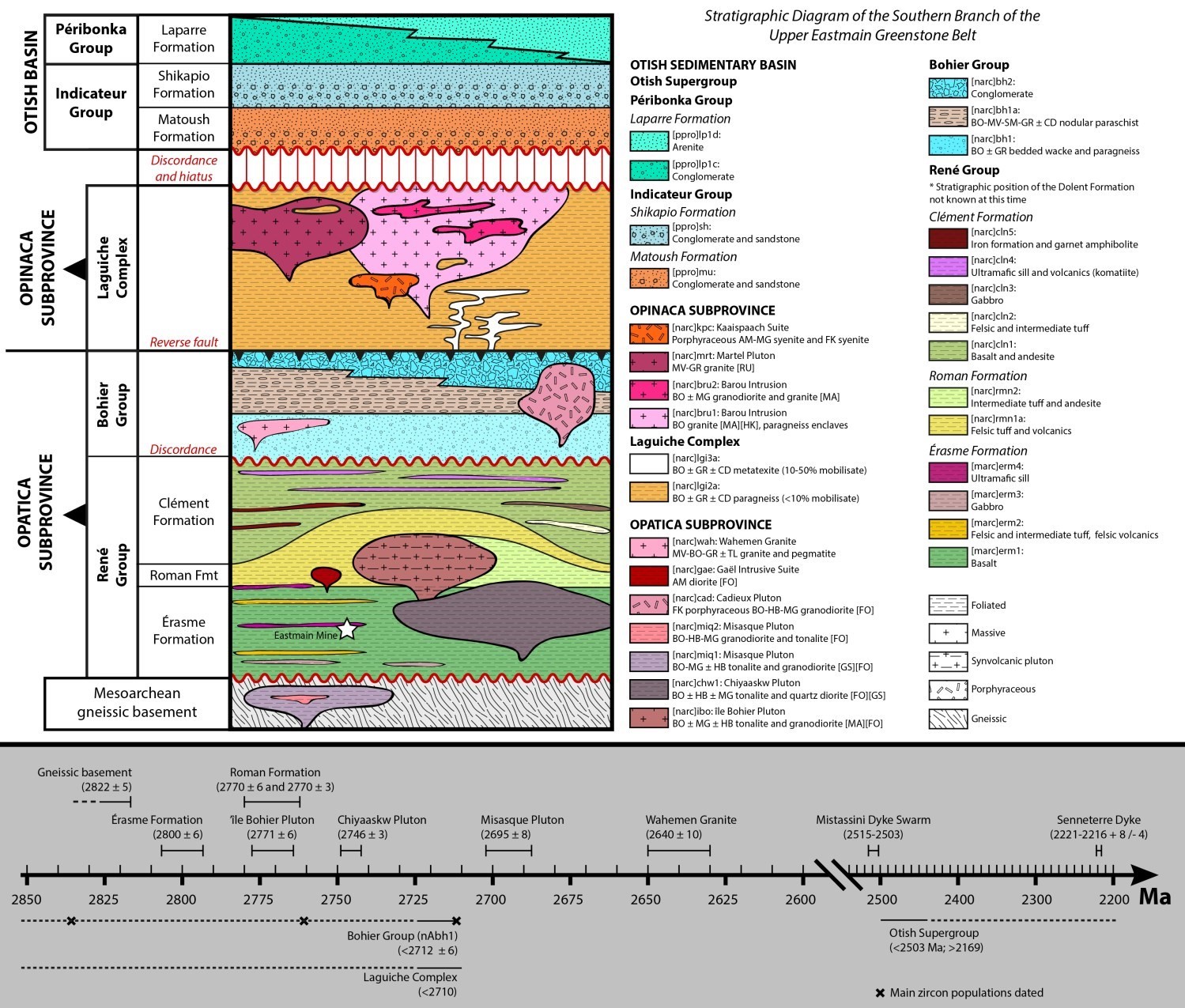
The rocks in the region have been grouped into different lithostratigraphic and lithodemic units in accordance with the North American Stratigraphic Code (ministère de l’Énergie et des Resources, 1986; American Commission on Stratigraphic Nomenclature, 2005; Easton, 2009) and taking into account the nomenclature already established. The relative timing of these units is illustrated in a stratigraphic diagram that takes into account cross-cutting relationships described in the field and the available U-Pb geochronological data.
OPATICA SUBPROVINCE
The Upper Eastmain Greenstone Belt (UEGB) consists of two large groups: the René Group (Are), which consits mainly of metavolcanic rocks, and the Bohier Group (nAbh), which consists of metasedimentary rocks.
The fieldwork resulted in a new stratigraphic interpretation of the UEGB. In this model, the René Group is presented as a succession of volcanic episodes corresponding to four formations. From the base to the top of the volcanic pile, this succession consists of the Érasme Formation (nAerm; 2800 ±6 Ma), the Roman Formation (nArmn; 2770 ±3 Ma; 2774 ±6 Ma) and the Clément Formation (nAcln). The stratigraphic position of the fourth formation, the Dolent Formation (nAdln), is still uncertain.
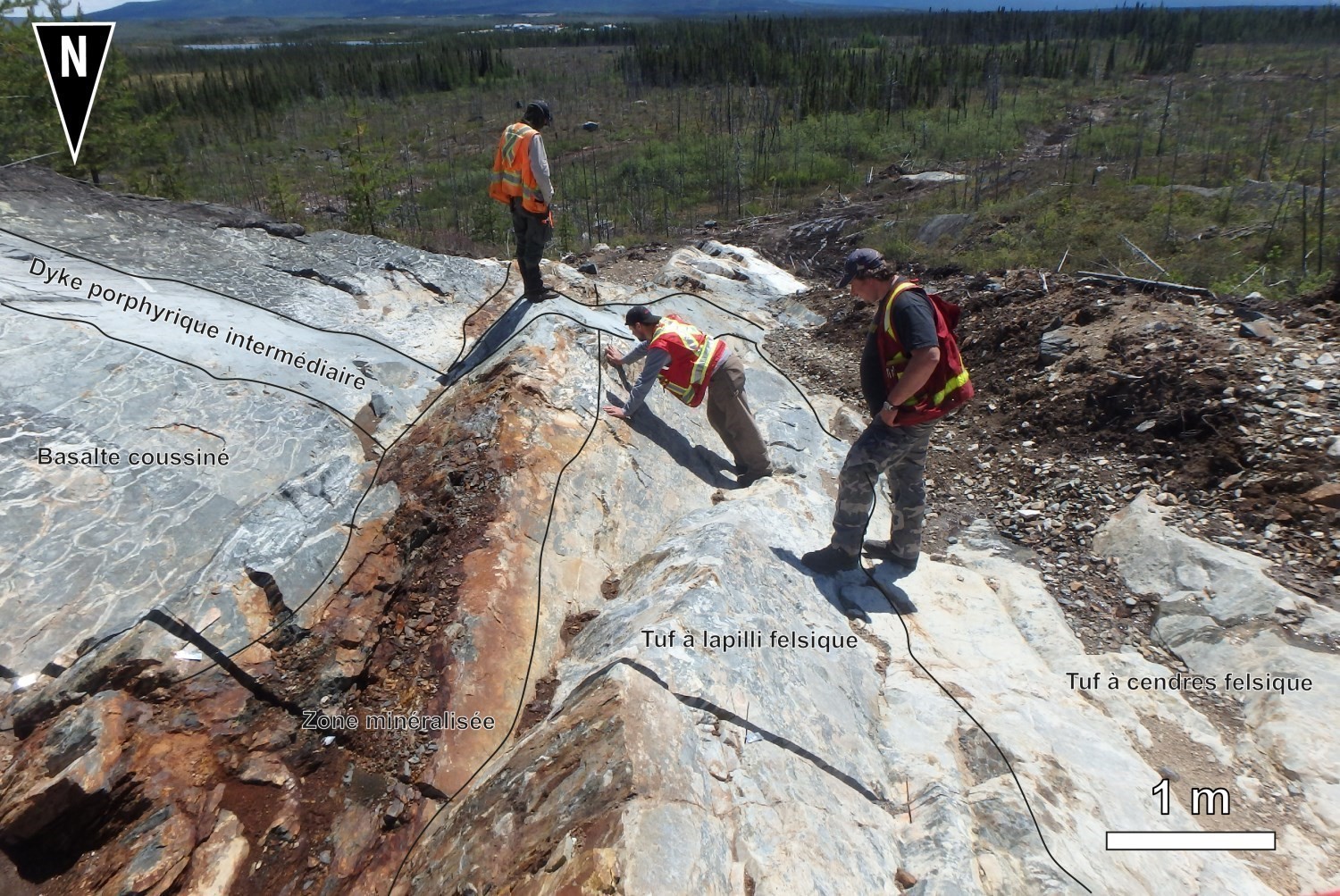
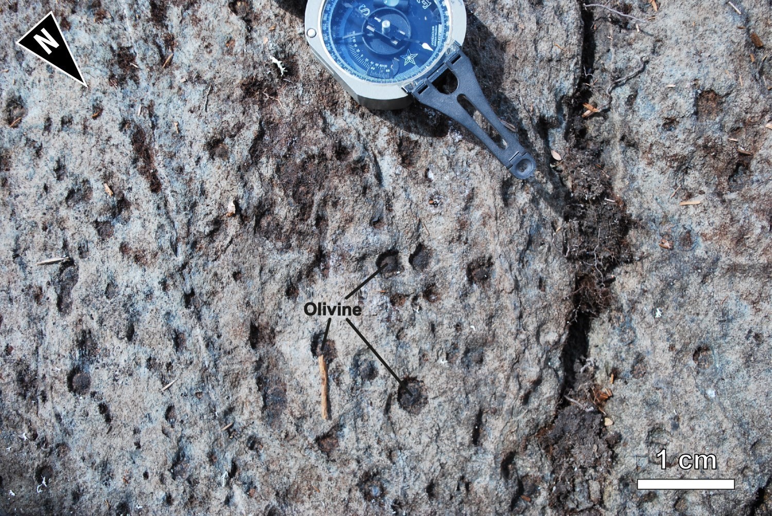
The Érasme Formation (nAerm) is the first volcanic episode of the René Group and it is divided into four units along the south branch of the UEGB. The Érasme Formation consists mainly of basalt and amphibolitized andesitic basalt that regularly show a pillow structure (nAerm1). Porphyritic or glomeroporphyritic basalts with plagioclase phenocrysts were grouped in the nAerm1a subunit. Horizons of rhyolitic, rhyodacitic or dacitic lavas, and felsic ash, lapilli or block tuffs (nAerm2) are locally interspersed in the nAerm1 unit. Volcanic units are intruded by sills of gabbro and ultramafic rocks (nAerm3 and nAerm4a). Contact between the Érasme Formation and the overlying Roman Formation was not observed on the field. However, a break in volcanism or movement in a shear zone that would have truncated part of the volcanic assemblage could explain the 30 Ma difference between the emplacement of the Érasme and Roman formations.
The Roman Formation (nArmn), the second major volcanic episode of the René Group, outcrops along the southern and eastern branches of the UEGB. It consists of eight units, of which only six have been mapped in the Bohier Island area. The first unit is subdivided into two subunits, nArmn1a and nArmn1b, of similar lithological characteristics. They consist of rhyolitic and rhyodacitic lavas, along with felsic tuffs. However, their geochemical signatures are different and they are geographically apart. Unit nArmn1a outcrops in the south branch, while unit nArmn1b outcrops in the east branch. The remaining five units consist of andesite and intermediate tuff (nArmn2), gabrro (nArmn3), amphibolitized basalt (nArmn4), paraschist and paragneiss from wacke (nArmn7) and ultramafic sill (nArmn8). Units of iron formation and garnet amphibolite (nArmn5) and mudstone and graphitic chert (nArmn6) have not been mapped in the study area.
The Clément Formation (nAcln) is the third major volcanic episode of the René Group. It consists of lithologies similar to those of the Érasme Formation, as well as some sedimentary horizons. It is composed of basalt (nAcln1), felsic and intermediate tuffs (nAcln2), gabbro (nAcln3), ultramafic sills and volcanics (nAcln4) and iron formation and garnet amphibolite (nAcln5).
Finally, the Dolent Formation (nAdln), which combines volcanic rocks of the western and northern branches, as well as that of the northern edge of the eastern branch, is divided into 5 units: a predominantly basaltic unit (nAdln1), a unit of gabbro (nAdln2), an ultramafic intrusive rock unit (nAdln3), an ultramafic volcanic rock unit (nAdln4), and a unit of sulphidic chert and iron formation (nAdln5). The stratigraphic position of this formation in the René Group is still undetermined.
Metasedimentary rocks of the Bohier Group (nAbh) unconformably overly metavolcanic units of the René Group. The Bohier Group is divided into three informal units. The basal unit (nAbh1) is observed in the east branch and on the southern edge of the western branch of the UEGB. It is made up of bedded wackes and biotite-garnet paragneisses. The intermediate subunit (nAbh1a), which is predominantly exposed on Bohier Island and north of the southern branch, is a of biotite-muscovite-sillimanite-garnet ± cordierite nodular paraschist. It has beds more or less rich in sillimanite or garnet, testifying to the variation in the protolith composition. The top unit (nAbh2) is a polygenic or monogenic conglomerate whose fragments (granite, tonalite, diorite, gabbro, mafic and felsic volcanics) are similar in nature to those in the surrounding area. These conglomerates are on Bohier Island and in the earth of the western branch.
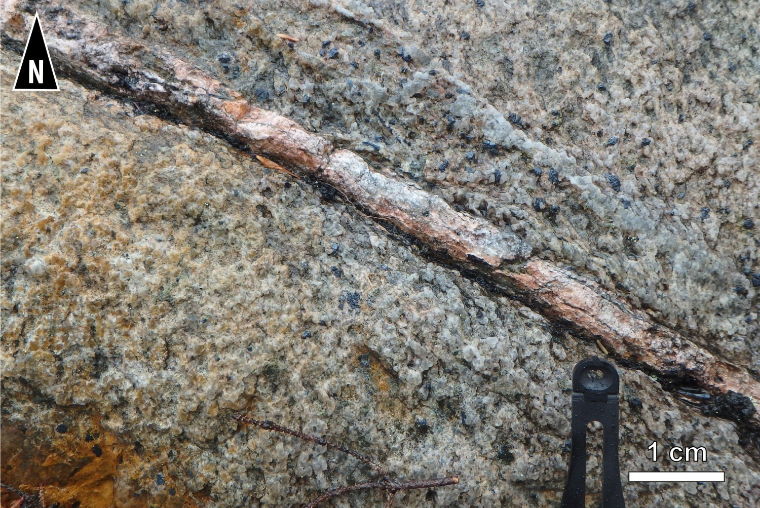
The UEGB is surrounded by four intrusive units, the empacement of which contributed to its shape. East of the belt, the Bohier Island Anticlinal axial part is occupied by the Île Bohier Island synvolcanic Pluton (nAibo, 2771 ±6 Ma; Davis, personal communication). The pluton is composed of tonalite and granodiorite, both containing biotite-magnetite-hornblende. It is more affected by a deformation marked by the elongation of quartz crystals than by ferromagnesian minerals, which appear in clusters. On magnetic field maps, this pluton shows a grain consistent with the belt shape. It is also characterized by widespread carbonatization. Further east is the Chiyaaskw Pluton (nAchw), whose nAchw1 unit, dated at 2746 ±3 Ma, is composed of foliated, locally banded, gneissic tonalite and quartz diorite, both containing biotite-hornblende-magnetite. To the northwest of the belt is the Misasque Pluton (nAmiq, 2695 ±3 Ma), composed of tonalite, tonalitic gneiss and gneissic granodiorite, all of which are rich in biotite-magnetite ± hornblende. The foliated, banded and gneissic granodiorite is predominantly localized in unit nAmiq2 u. Finally, the Cadieux Pluton (nAcad) appears in two parts. One is located in the axial part of the Hécla Lake Anticlinal, surrounded by the north and east branches of the UEGB, while the other runs along the southern edge of the west branch. This pluton is composed of foliated biotite-hornblende-magnetite granodiorite, showing a porphyraceous structure with K-feldspar phenocrysts.
The Wahemen Granite, an undeformed medium-grained to pegmatitic granitic intrusion cuts rocks of the Bohier Group to the northeast of the mapped area. The Gaël Intrusive Suite is made up of small dioritic plutons intruding into volcanic units surrounding the Eastmain Mine. Finally, completely southwest of sheet 33A01 are two small foliated tonalitic intrusions that may also belong to the Opatica Subprovince.
OPINACA SUBPROVINCE
In the eastern portion of the study area, contact between the Opinaca and Opatica subprovinces passes south of the Cadieux Pluton. To the west, it is marked by the Bart thrust fault bordering the south branch of the Upper Eastmain Belt. In the southeastern part of the mapped area, Opinaca rocks are unconformably overlain by sedimentary rocks of the Otish Supergroup.
Most of the Opinaca Subprovince is occupied by the Laguiche Complex (<2710 Ma; Augland 2016), which is composed of paragneiss (nAlgi2a) and paragneiss metatexite (nAlgi3a) units. This complex occupies the southwest of sheet 33A08 and the low topographic elevations of sheet 33A01. Paragneiss xenoliths are also found in granitic intrusions of the area. The Laguiche Complex is cut by several intrusive units. The largest is the Barou Intrusion (nAbru), which is composed of massive biotite-magnetite granite (nAbru1) with more granodioritic zones (nAbru2). These intrusive rocks, which are more resistant to erosion than those of the Laguiche Complex, form the terrain of the Otish Mountains in the study area. The Barou Intrusion is itself cut by banded muscovite-garnet granite of the Martel Pluton (nAmrt), which outcrops in the western part of the Otish Mountains. The Kaaispaach Suite (nAkpc) also cuts the Barou Intrusion. This new unit consists of syenite and amphibole-magnetite alkaline syenite. These syenites are massive and porphyraceous with K-feldspar phenocrysts. Rocks of the Laguiche Complex and Barou Intrusion are also cut by a series of minor intrusions of granitic to dioritic composition.
Finally, several ultramafic rock intrusions were mapped or extrapolated using the aeromagnetic map. These rocks are mainly hosted in the Opinaca metasedimentary rocks, but one of these intrusions crosses the contact between the Opinana and Opatica subprovinces south of sheet 33A08.
NEOARCHEAN AND PALEOPROTEROZOIC MAFIC DYKES
The study area is cut by two swarms of mafic dykes of Neoarchean and Paleoproterozoic age. The SE-NW dykes of massive gabbronorite belong to the Mistassini Dyke Swarm (nAmib; 2515-2503 Ma). A younger gabbroic to gabbronoritic dyke, oriented WSW-ENE, may be linked to the Senneterre Dykes (pPsen; 2221-2216 Ma). These dykes cut all units in the region, except those of the Otish Basin.
SEDIMENTARY ROCKS OF THE OTISH BASIN
The southeastern part of the region consits of Paleoproterozoic sedimentary rocks belonging to the Otish Supergroup (<2503 Ma and >2169 Ma). These are mainly arenites and quartz-pebble conglomerates that lie unconformably on Archean rocks. The Otish Supergroup is divided into two groups: the Indicator Group, at the base, and the Peribonca Group, at the top. Rocks of the Indicator Group do not contain plagioclase. They have been emplaced in a reducing environment and essentially have monogenic conglomerates. In contrast, rocks of the Peribonca Group contain up to 5% plagioclase. They reflect an oxidizing environment and include polygenic conglomerates. In the study area, three detrital formations belonging to these two units have been recognized. The Matoush and Shikapio formations, belonging to the Indicator Group, have very little exposure in the study area and are found northeast of sheet 33A01. The Laparre Formation (pPlp), belonging to the Peribonca Group, outcrops southeast of sheet 33A01. It and has been subdivided into two informal units: the pPlp1c unit consits of conglomeratic facies, while the pPlp1d unit corresponds to the arenitic facies.
STRUCTURAL GEOLOGY
Geological mapping of the Bohier Island area has identified at least three phases of ductile deformation identified as D1, D2, D3, as well as a subsequent fragile event D4.

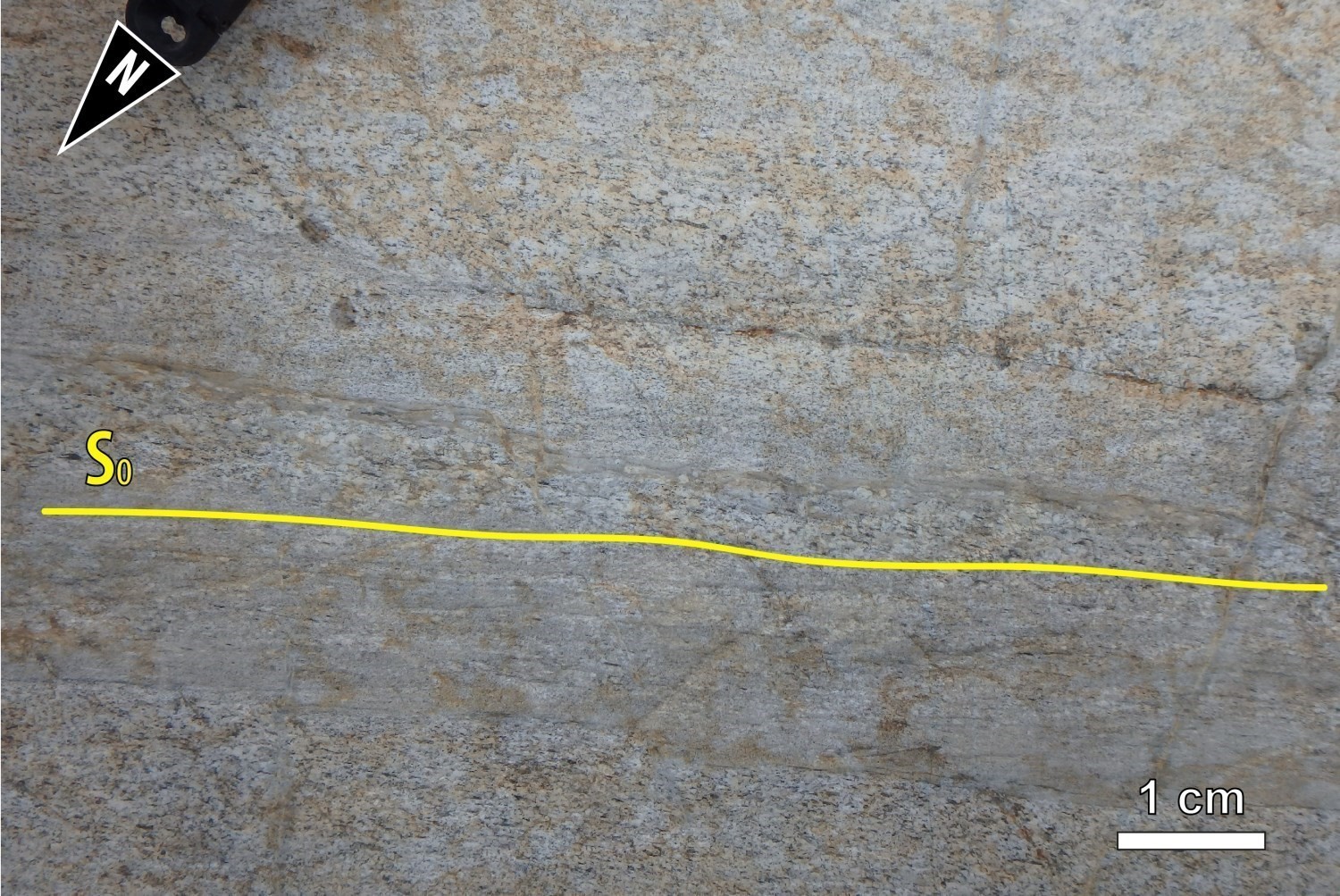
PRIMARY STRUCTURES
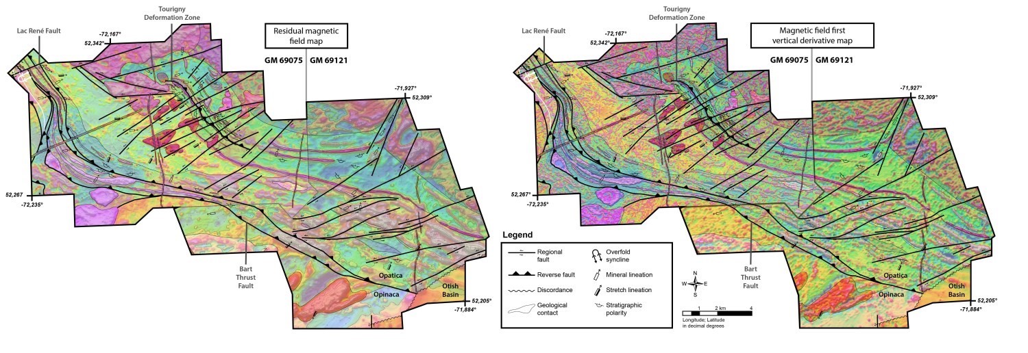
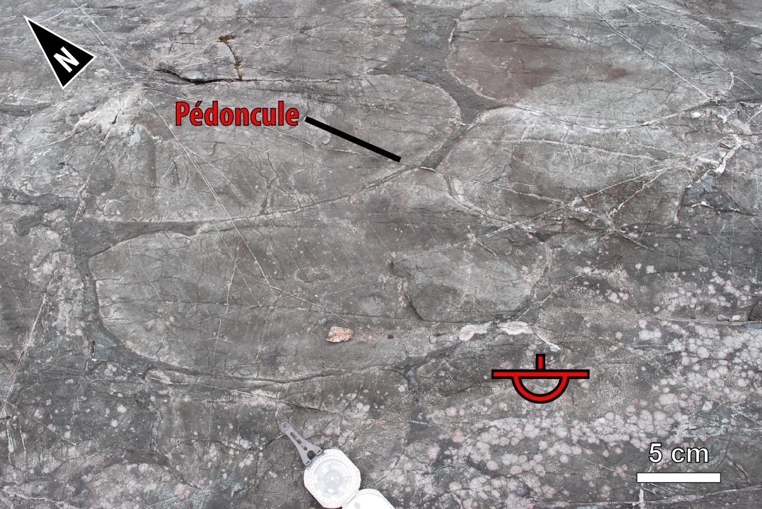
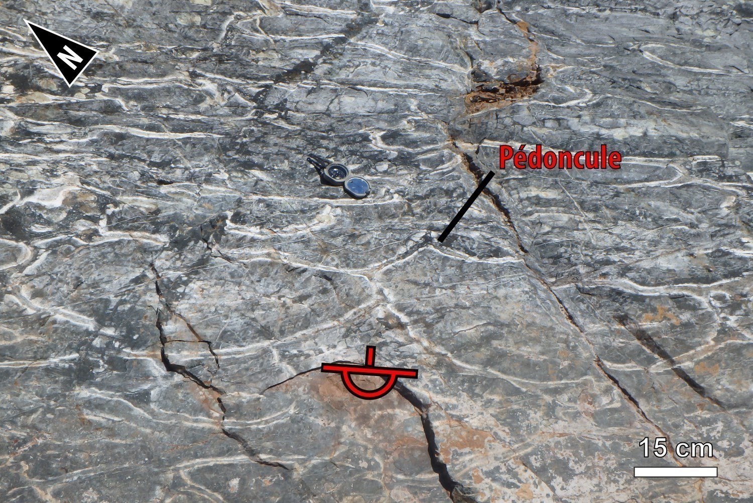
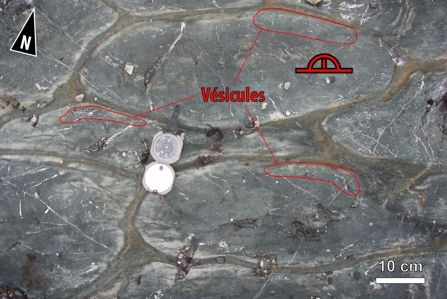
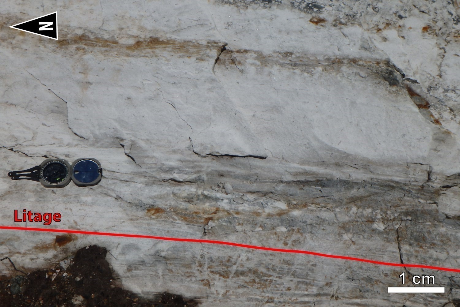
Primary structures that locally allow local orientation of S0 stratification (pillow basalts, peduncles, quartz chambers, vesicles, graded tuffs and wackes, bedding, etc.) are generally well preserved in metavolcanic and metasedimentary units of the René and Bohier groups. Some intrusions have retained relics of their setting. For example, the internal structure of the Bohier Island synvolcanic Pluton, which is visible on magnetic maps, is consistent with primary magmatic foliation. This fabric has the same orientation as the S0-S1 composite foliation of the UEGB's volcano-sedimentary rocks.

DEFORMATION PHASE (D1)
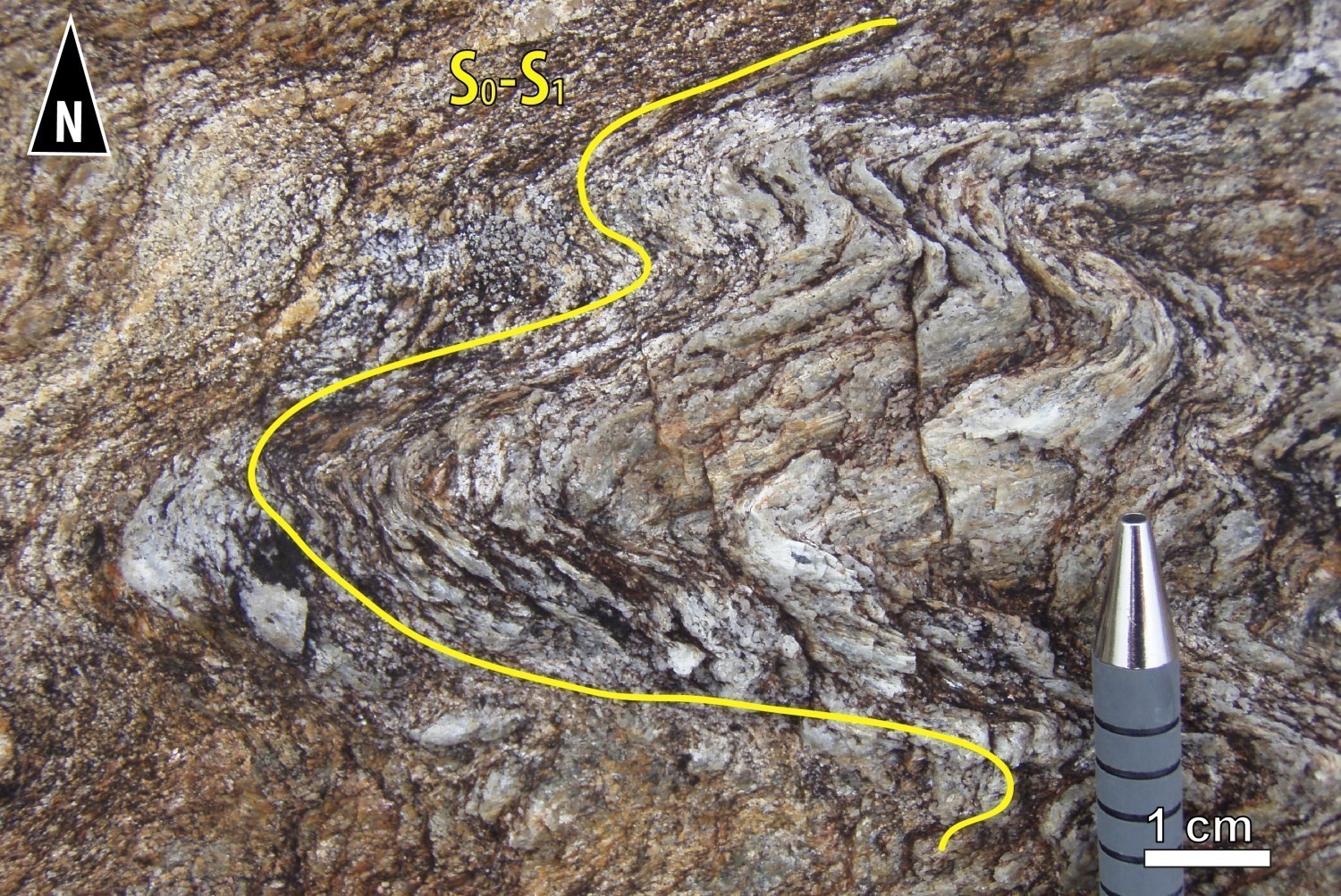
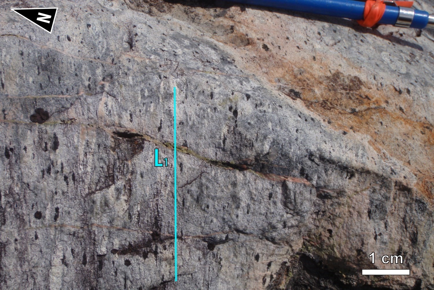
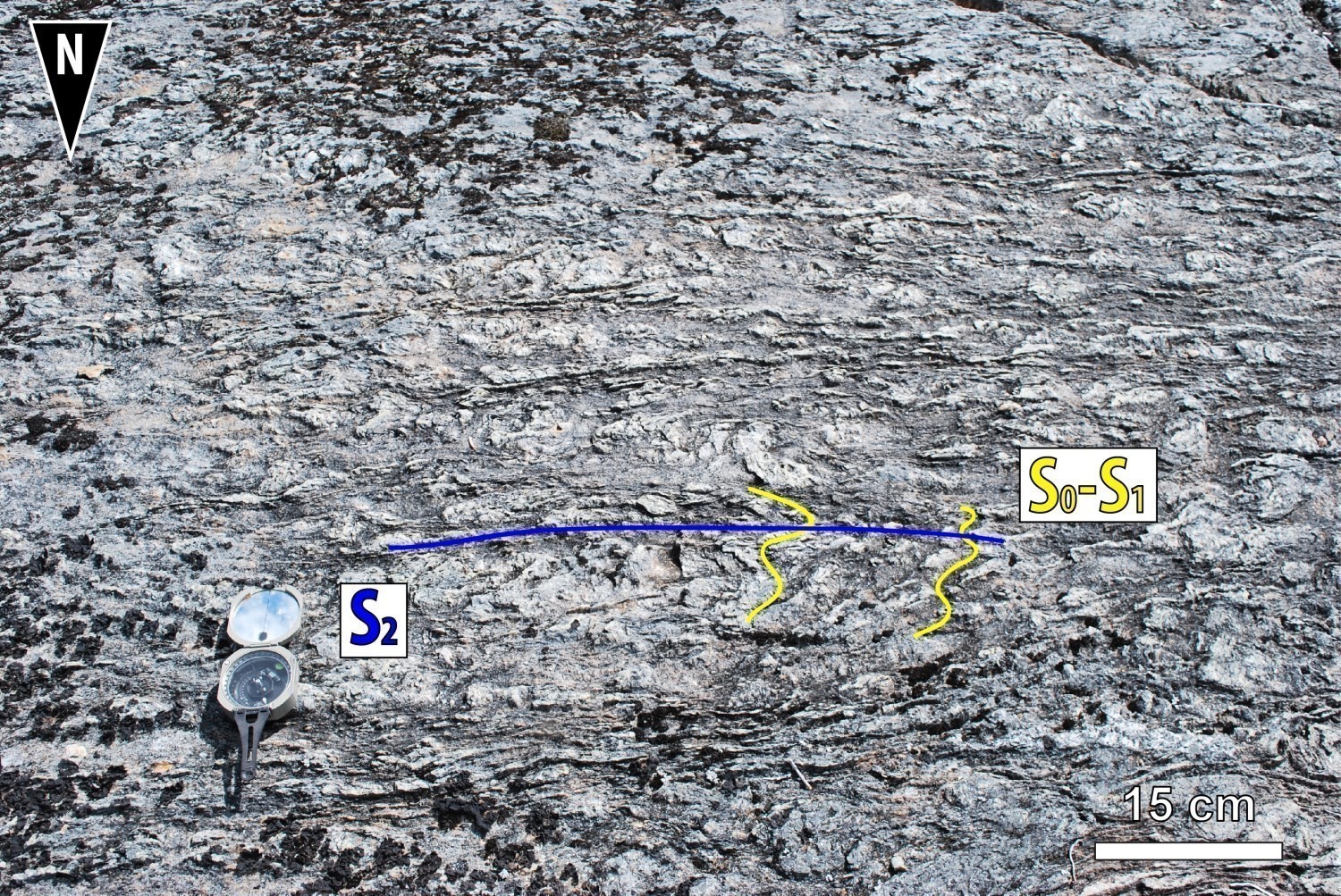
The first phase of deformation D1, visible at the outcrop scale, is manifested by a foliation and a penetrating schistosity S1 observed throughout the mapped area. This fabric on which stratification (S0) is transposed is particularly well expressed in the centre of Bohier Island in the nodular paraschist unit (nAbh1a). The tectonometamorphic S1 fabric is marked by the preferential alignment of micas (biotite and muscovite) and sillimanite. Regionally, the S0-S1 composite fabric undulates and varies from NW-SE to ENE-WSW to N-S. A mineral and stretch lineation L1 is associated with S1 schistosity and has been primarily observed in UEGB units.
Field observations, regional aeromagnetic survey and company magnetic surveys (St-Hilaire 2013; Dubé 2015) were used to plot several deformation zones developed during phase D1. The F1 faults associated with these areas are oriented NNW-SSE to WNW-ESE and dip to the NNE and ENE. These early faults are characterized by inverse thrust movements. A few normal movements were observed. These first-order faults cut out the south branch of the UEGB. One of the largest in the region, the Bart Thrust Fault marks the contact between the Opatica and Opinaca subprovinces. In the Opinaca Subprovince, NNE-SSW oriented magnetic lineaments are clearly cut by the Bart thrust fault. East of the fault, in the Opatica Subprovince, foliation S1 and magnetic lineaments are oriented NW-SE and rocks have a average dip of 50° to the NE. The dip of the S0-S1 composite fabric in the volcanic sequence of the south branch of the UEGB is reduced approaching the Bart thrust fault (~20° towards the NE).
The Tourigny Deformation Zone (Tourigny, 1989) is another fault developed during phase D1 in the Bohier Island area. This deformation zone affects the Mine Series Package assemblage. Frappier-Rivard (2015) describes two main faults, one on the wall of the deformation zone and one on the roof. The wall fault, which is superimposed on an ultramafic sill, is more developed than the fault of the roof. The latter cuts several lithologies (felsic, mafic, ultramafic). These faults, up to 10 cm thick, are subparallel to stratification. Kinematic indicators (C/S fabrics, asymmetrical boudinage), associated with NE-SW oriented L1 mineral and stretch lineation, usually involve reverse movement (Tourigny 1989; Couture 1993; Frappier-Rivard 2015). However, a few drill core observations in 2010 and 2011 recorded both normal and inverse movements (Frappier-Rivard, 2015). The heterogeneities (mechanical and chemical) between ultramafics and their hosted rocks may have favoured and controlled the development of the Tourigny Deformation Zone.
DEFORMATION PHASE (D2)
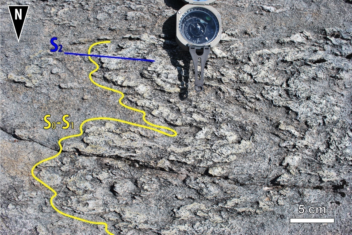
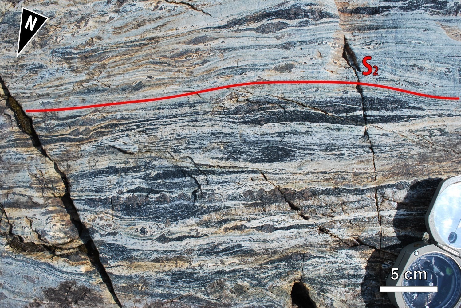
In the Opatica and Opinaca subprovinces, the regional deformation event D2 is manifested by penetrative S2 foliation that overprints S1 foliation. S2 foliation has a moderate dip to the south or to the north and is marked par the preferential orientation of micas, some amphiboles and sillimanite. The region is also affected by kilometric P2 folds of axial planes S2 and E-W to ENE-WSW orientation (Lake Hecla and Bohier Island Anticlinals, synclines of the eastern and western branches). S2 foliation and F2 regional shear zones are well developed in the eastern and western UEGB branches.
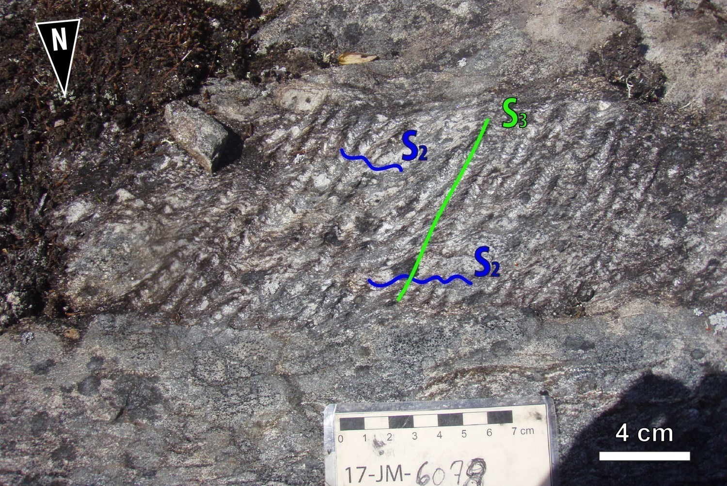
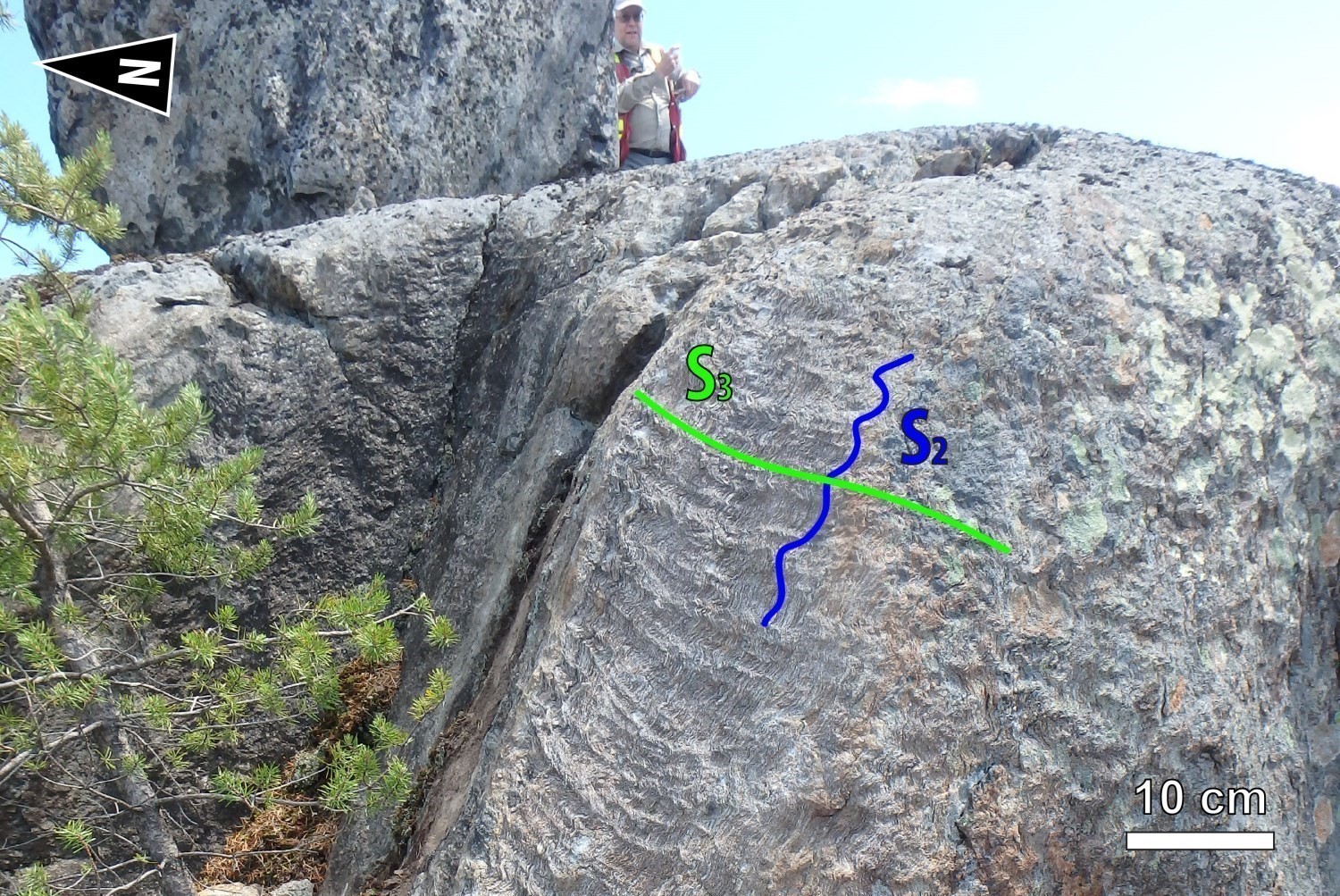
DEFORMATION PHASE (D3)
The deformation phase D3 results in a spaced S3 crenulation cleavage that overprints the S2 foliation in volcano-sedimentary rocks of the René and Bohier groups. P3 regional folds of NW-SE orientation and axial planes S3 also affect the volcanic and sedimentary sequence of the René and Bohier groups.
DEFORMATION PHASE (D4)
A brittle deformation phase D4 faulted the region. A family of sinistral faults oriented ENE-WSW to E-W moved the units in the Bohier Island area. The Lac René Fault is one of the most important of this family of faults. Volcanic and sedimentary units show a shift on either side of René Lake. In fact, the iron formations (nAcln5), which are a marker level in the southern branch of the UEGB because of their high magnetic susceptibility, have been moved 250 m by a sinistral movement. The existence of very detailed magnetic maps along the southern branch of the UEGB (St-Hilaire, 2013; Dubé, 2015) mapped numerous fragile faults. The sinistral-component kinetics of the majority of these faults are observed in the "Mine Series Package" (described in the Economic Geology section) and in the mineralized zones of the Eastmain Mine area, where a sinistral fault moves and marks the boundary between Zones A and B of the deposit (Yassa, 2018). Finally, a NW-SE oriented family of F5 faults show dextral movements. These faults cut the Cadieux Pluton, south of the western branch of the UEGB.
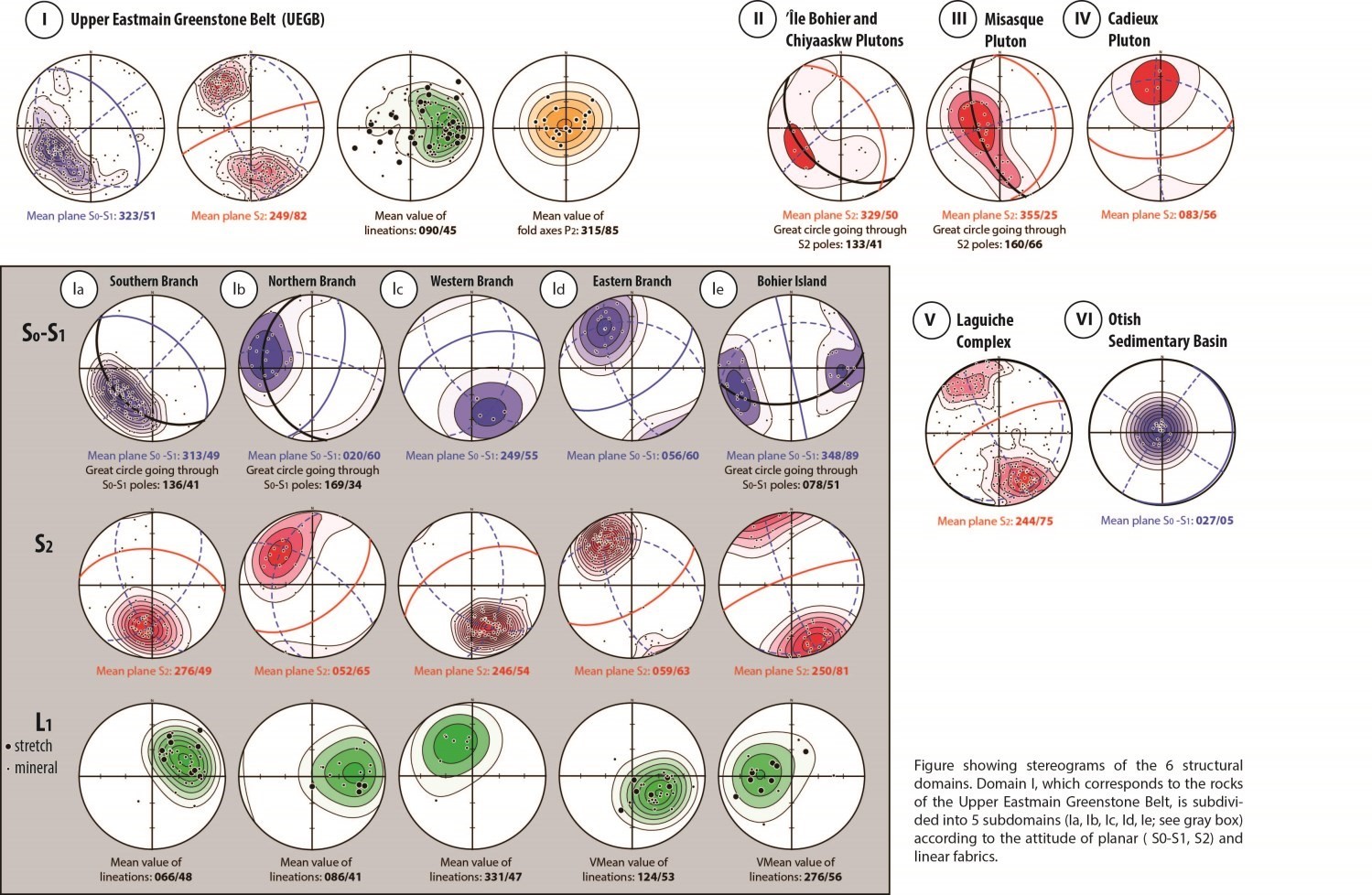
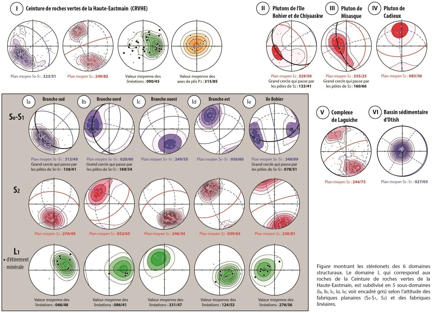
STRUCTURAL DOMAINS
The mapped area is divided into six structural domains on the aeromagnetic map, characterized by the general orientation of foliations and lineations. Three structural sections illustrate the layout of the UEGB.
Domain I: Upper Eastmain Greenstone Belt (Opatica)
The following five subdomains were plotted in the UEGB.
The southern branch corresponds to an overturned, homoclinal volcanic sequence characterized by the stacking of three volcanic formations and a sedimentary group. In this area, well-preserved pillow basalts allow to determine with certainty stratigraphic polarity. The polarities are systematically reversed, showing an orientation towards the SW and towards the south. The stratification dip is approximately 50° northward. The base of the volcanic and sedimentary pile is overturned and begins with the Érasme Formation in the northwest. The pile ends westward with the Bohier Group, which is therefore structurally at the base. A P1 synclinal fold was interpreted north of the south branch through polarity inversions in sedimentary rocks of the Bohier Group on either side of the trace. This axis is subparallel to stratigraphy and passes within the nodular paraschist unit (nAbh2a). A series of thrust faults allowed the juxtaposition of volcano-sedimentary rocks of the Opatica Subprovince with sedimentary rocks belonging to the Opinaca Subprovince. The S1 fabric is dominant in the south branch. The S1 foliation poles in this subdomain indicate that the southern branch moulds on an anticlinal dome, the central part of which is occupied by the Île Bohier synvolcanic Pluton (nAibo) and the Chiyaaskw Pluton (nAchw). The poles define a great circle (median plane: 136°/41°). The geometric relationship between the southern (dip at 49°) and the eastern (dip at 60°) branches suggests that the axial plane of the Bohier Island P2 Anticlinal would be slightly overfold to the south. The P2 fold axis calculated in this domain is 046°/49°. Regional foliation S2, oriented at 276°/49°, intersects the S1 fabric. Mineral and stretch lineations dip moderately to the NE (066°/48°).
The north branch forms the north and west flank of an anticline, the axial part of which is occupied by the Cadieux Pluton (nAcad). The axial plane of the Hecla Lake Anticlinal, overturned northward, dips towards the SE. The stratification is highlighted by a horizon of N-S oriented porphyritic to glomeroporphyritic basalt that has been tracked for several kilometres. The S1 fabric, oriented at 020°/60°, is better developed in the north branch than the S2 fabric, which is located at 052°/65°. L1 lineations dip about 40o eastward.
The west branch represents a P2 synclinal fold overturned southward. The rocks of this branch belong to the Dolent Formation. At the base of the stratigraphy are mafic and ultramafic rocks (intrusive and volcanic). They are overlain by pillow basalts. The axial part of the syncline of the west branch is occupied by polygenic conglomerates of the Bohier Group (<2712 ±6 Ma) that lie unconformably on volcanic rocks of the René Group. The rocks in this area are mainly affected by regional foliation S2. As illustrated on stereograms, the S0-S1 composite fabric (249°/55°) was transposed to S2 foliation. The median plane of regional foliation S2 is 246°/54°. Lineations dip moderately towards the NW.
Rocks of the east branch are more metamorphosed and more deformed than those of the south branch. Stratigraphic polarity indicators are therefore rarer. Some polarity reversals are used to define P2 folds. South of the east branch, two folds can be identified, a syncline and an anticline overfold northward. A F2 regional shear marks contact between volcanic rocks of the Roman Formation (nArmn) and metasedimentary rocks of the Bohier Group (nAbh). Further northwest, the eastern branch P2 syncline, located in the earth of the Bohier Group wacke and paragneiss unit is overfolded northward. WSW-ENE oriented stratification is much more difficult to trace due to the deformation. It is underlined by a porphyritic basalt marker horizon south of Tiers-État Lake. Shear zones subparallel to S2 foliation likely contributed to shifting the stratigraphic units. The rocks of the east branch have ENE-WSW oriented regional S2 foliation with moderate dip towards the SSE (059°/63°), as well as mineral and stretch lineations dipping about 53° to the SE. The western and eastern branches, which show lithological continuity, therefore have opposite dip.
The Bohier Island area is structurally complex. This is where the four branches of the UEGB come together. At this location, cross-cutting relationships identify the three phases of ductile deformation D1, D2 and D3. On several paraschist outcrops, the relationships between the different deformation phases can be observed. The S0-S1 composite fabric, overall N-S, is cut off by the regional foliation of S2 axial plane. The latter is ENE-WSW oriented and associated with tight P2 folds. A weakly to moderately dipping S3 crenulation cleavage is oriented NW-SE. Lineations dip moderately eastward and towards the NE.
Domain II: Île Bohier and Chiyaaskw Plutons (Opatica)
Domain II includes the Chiyaaskw syntectonic Pluton and the Île Bohier synvolcanic Pluton (nAibo). The two intrusions are in the axial part of the Île Bohier Anticlinal. The Chiyaaskw Pluton is foliated. The poles of S2 foliations define a great circle oriented at 133°/41°. The Île Bohier Pluton is massive to locally weakly foliated. It recorded S1 foliation and is characterized by NNE-SSW to NNW-SSE-oriented magmatic banding.
Domain III: Misasque Pluton (Opatica)
Tectonometamorphic foliation and gneissic banding of this domain were essentially observed in the Misasque Pluton. The S2 foliation poles define a great circle oriented at 160°/66°. The theoretical P2 folding axis calculated for this domain indicates a shallow dip towards the ENE.
Domain IV: Cadieux Pluton (Opatica)
The Cadieux syntectonic Pluton is located in the axial part of the overfold Hecla Lake Anticline. This area has very little exposure and most of the structural data comes from outcrops south of the intrusion near the eastern branch of the UEGB. The median plane of S2 foliation in this porphyraceous granodiorite is oriented at 083°/56°.
Domain V: Laguiche Complex (Opinaca)
Domain V corresponds to migmatitized metasedimentary rocks and granitic intrusions of the Laguiche Complex. This complex represents more than half of the mapped area. In this domain, stereograms illustrate the attitude of migmatitic banding, G2 gneissosity and S2 tectonometamorphic foliation. Domain V foliation poles define a median plane oriented mainly ENE-WSW with a dip of about 75° northward or southward. Very few stretch lineations (eastward or westward) were measured. Several late intrusions cutting paragneisses and metatexites are massive (Kaaispaach Suite, Barou Intrusion).
Domain VI: Otish Sedimentary Basin
Conglomerates and quartz arenites of the Otish Supergroup have subhorizontal bedding with a median plane of 027°/05°. A few paleocurrent directions were measured to the south or southeast. In this area, Paleoproterozoic rocks of the Otish Basin are not deformed.
TECTONIC EVOLUTION OF BOHIER ISLAND AREA
The arrangement of units in the Bohier Island area appears to be partly the result of vertical tectonics. Comparable examples have been documented elsewhere in different Archean cratons (e.g. Campbell and Hill, 1988; Collins et al., 1998; Bleeker, 2002; Parmenter et al., 2006; Lin et al., 2013). Vertical movements would have led to the formation of a basin during phase D1. This basin would have been filled by sedimentary rocks (the Bohier Group) whose products could come from the erosion of the René Group volcanic assemblage and intrusive rocks of the underlying basement, in neighboring dome areas. This basin would have undergone a subsequent folding phase during the D2 event, which would have led to the geometry of several branches of the UEGB. These branches, along which René Group rocks are exposed, could mold domes of plutonic rocks formed during phase D2.
METAMORPHISM
The study area presents three geological assemblages (Opinaca Subprovince, Opatica Subprovince and Otish Basin) affected differently by metamorphism.
In the Opinaca Subprovince, metasedimentary rocks of the Laguiche Complex show a low degree of partial melting. Paragneisses show a mineralogical assemblage with plagioclase, quartz and biotite. They do not contain amphibole. The same is true of Barou Intrusion biotite granite. At some point, partial melting was more extensive and rocks became metatexites, particularly in the centre of the 33A01 sheet. Amphibole and garnet may then be present. Metasedimentary rocks of the Laguiche Complex would then have reached the upper amphibolites facies.
Several metamorphic events have been dated in the Opatica Subprovince. They range from 2.69 to 2.68 Ga and from 2.66 to 2.64 Ga (Davis et al., 1995) and coincide with the Kenorean Orogeny. In the study area, mafic rocks of the Opatica Subprovince generally show hornblende and garnet assemblages, typical of the amphibolite facies. In the UEGB, amphibole-rich volcanic rocks are predominantly at the amphibolite facies, although locally the rocks have been retromorphosed to the greenschist facies. Metasediments of the Bohier Group show a sillimanite-cordierite-garnet-muscovite assemblage typical of the upper amphibolite facies. Sillimanite appears locally as pseudomorph of andalusite. The transition from andalusite to sillimanite associated with cordierite is typical of a metamorphism of relatively low pressure and high temperature. The observed paragenesis therefore indicate that the rock reached temperatures between 500 °C (appearance of sillimanite) and 700°C (replacement of muscovite by K-feldspar). At outcrop 17-AB-1111 on the northern part of Bohier Island, a polygenic conglomerate contains staurolite, in addition to garnet and biotite. Staurolite is a good marker for the transition from greenschist facies to amphibolite facies.
Finally, detrital sediments of the Paleoproterozoic Otish Supergroup show no evidence of metamorphism.
ECONOMIC GEOLOGY
The Bohier Island region shows prospective zones for five types of mineralization:
- Exhalative sulphide mineralization;
- Lode gold or base metal mineralization;
- Porphyry-type mineralization;
- Magmatic nickel-copper mineralization (± cobalt ± platinum group elements) associated with mafic to ultramafic intrusions;
- Diamond mineralization associated with kimberlites.
Uranium mineralization will not be discussed in this report.
The table below presents the analytical results for the thirty-six (36) known mineralizations in the area. No new showings were discovered during the field campaign.
Mineralizations in the Bohier Island Area
(E): Selected sample; (R): Channel; (F): Drillhole
The table of lithogeochemical analyses of metals of economic interest providess location, description, and showing, anomalous and significant values for sixty (66) samples selected to assess the economic potential of the region.
EXHALATIVE SULPHIDE MINERALIZATION
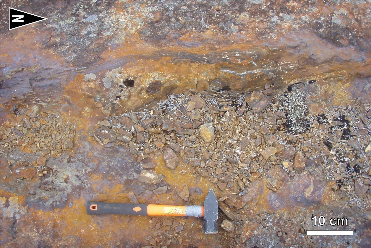
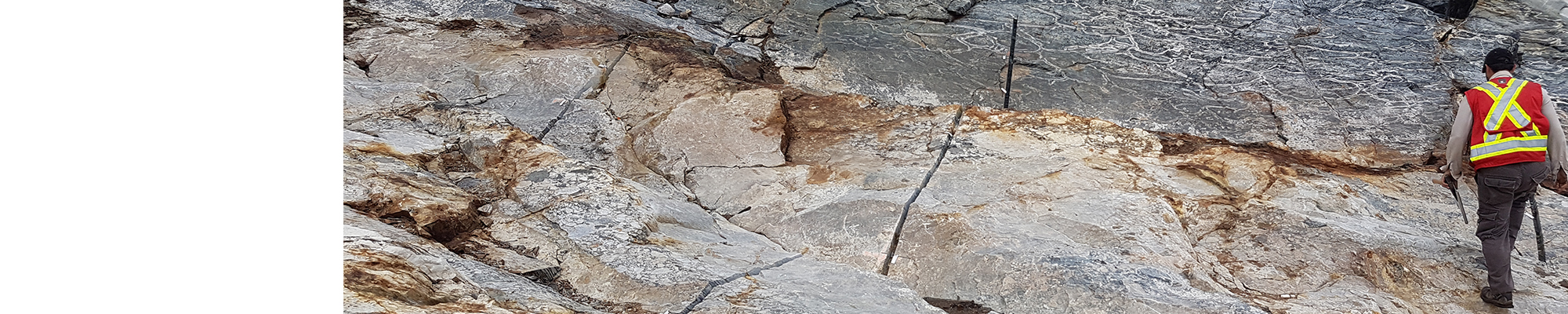
The Upper Eastmain Greenstone Belt has great potential for exhalative stratiform mineralization. These disseminated sulphide zones, semi-massive to massive, are composed of pyrite, pyrrhotite, chalcopyrite and locally sphalerite. They are also gold bearing. Mineralization is generally associated with cherty horizons at the contact between felsic horizons and basalts, suggesting that the associated alterations occurred during a break in volcanic activity. The Lac Érasme (2.72% Cu, 8.25 g/t Au and 7.3 g/t Ag) and Colline de Château Fort (3.3 g/t Au and 1.78% Zn) mineralizations were emplaced in this context. Several other rusted areas of the same type were also, but did not give an anomalous value. On outcrop 17-AB-1138, a disseminated to semi-massive pyrite chert was observed over a width of 45 m in contact with massive and pillow basalts.
GOLD MINERALIZATION

Three types of gold mineralization have been identified in the mapped area: lode, associated with iron formations and associated with shear zones. Setting of lode gold mineralization is highly dependent on regional deformation. Indeed, there is a strong association between lode gold mineralization and D2 deformation zones. A good example is the J4 stripping done by Eastmain Resources in 2016 (outcrop 17-AB-1125). This outcrop exhibits a quartz-calcite-actinote vein, 10 cm to 1.5 m wide, mineralized in pyrite, pyrrhotite and chalcopyrite over 80 m. Contents up to 8.29 g/t Au, 29.9 g/t Ag and 1.29% Cu over 1 m were obtained (Eastmain Resources In., December 12, 2016 press release). The NNE-SSW oriented vein is hosted in a foliated massive basalt. It is located in a steeply dipping fault zone parallel to S2 foliation which intersects S0-S1 composite foliation.
Iron formations are prospective lithologies for gold mineralization. They can act as a chemical trap for the precipitation of gold. The Lac René-Sud mineralized zone (1.11 g/t Au, Beesley, 1989; 1.65 g/t Au and 3.43 ppm Ag, Dobbelsteyn and Frappier-Rivard, 2015), hosted in silicified tuff in contact with pyroxenite, is located near an iron formation. Outcrops 17-JM-6019 and 17-SB-4102 exhibit rusted and banded iron formations. These formations are at the silicate and oxide facies. Pyrrhotite (traces to 10%) is present in silicate bands.
THE EASTMAIN MINE: A DEPOSIT OF VEIN-TYPE AND MASSIVE SULPHIDE MINERALIZATIONS
The former Eastmain Mine is the largest gold deposit in the UEGB. A total of 40,263 ounces of gold were produced in 1994-95 at 10.56 ppm Au. The typology of gold mineralization at the Eastmain Mine is controversial. In the 1980s, Boldy et al. (1984) interpreted this deposit as a volcanogenic massive sulphide. In the early 1990s, Couture and Guha (1990) and Couture (1993) suggested instead that gold mineralization of the Eastmain Mine would be hosted in orogenic veins in a brittle-ductile deformation zone. Following the summer of 2017 mapping work, the superposition of syngeneic volcanogenic mineralization and vein epigenetic mineralization is suggested to explain the gold budget of the Eastmain deposit.
The Eastmain mine deposit consists of three main mineralized zones, known as Zone A, Zone B and Zone C. These zones are located in the Érasme Formation along the same stratigraphic level. They are contained in a characteristic lithological package known as the "Mine Series Package". It consists of a subplanar assemblage of felsic rocks (tuffs and flows), mafic flows and ultramafic sills, deformed and altered, and whose dip is 35° to the NE (Frappier-Rivard, 2015). The gold zone is included horizons of mineralized recrystallized chert associated with massive to semi-massive sulphide lenses (pyrrhotite, pyrite, chalcopyrite, sphalerite) and silicified zones in felsic, mafic and ultramafic rocks. The Mine Series Package, which was plotted laterally for 10 km in a NW-SE direction, is a marker level for gold mineralization exploration in the Bohier Island area.
The stripping of the Hillhouse gold deposit (sample 17-JM-6010-D1 including 2160 ppb Au and 764 ppm Cu; sample Q206593 including 39.5 ppm Au and 4690 ppm Cu; Frappier-Rivard, 2015 and hole EM16-78 including 55.7 g/t Au over 0.7 m; Eastmain Resources Inc., October 5, 2016 press release), located about 1 km NNE from the former Eastmain Mine, is a good example of the mineralization style described in drilling in Zones A, B and C. Field observations made in the summer of 2017 by the MERN team suggest a syngenetic and volcanogenic origin for the Hillhouse showing. The characteristics of a VMS system (Dubé et al., 2007) present at Hillhouse are:
1) the presence of a semi-massive to massive sulphide stratiform lens (up to 50% pyrrhotite, chalcopyrite and sphalerite) that is conformable with stratification;
2) the position of the mineralized lens in the submarine volcanic pile, at the base of a felsic volcaniclastic horizon, in contact with a pillow basalt of transitional affinity;
3) zonality of the mineralogical assemblage at depth (Frappier-Rivard, personal communication). Since the volcanic sequence is overturned, sulphides that form at lower temperatures (galena, sphalerite and pyrite assemblage) are found at depth, while gold and chalcopyrite (mineralization that forms at higher temperatures) are more abundant at shallow depths. Gold values are closely associated with the presence of chalcopyrite;
4) the occurrence of discordant hydrothermal alteration zones with stratification suggesting the existence of alteration vents. Basalts of the Érasme Formation, especially those near and in the Mine Series Package, exhibit various hydrothermal alterations. The most common are silicification, chloritization, carbonatization, sericitization and biotitization. Regionally, metamorphosed aluminous alterations (muscovite, sillimanite, cordierite and garnet assemblage) occur in the felsic and intermediate rocks of the Roman Formation.
The introduction of gold into the mineralized system is not necessarily exclusive to the volcanogenic system. Gold could also be a late addition to the system. In the area of the Eastmain Mine, quartz veins that intersect stratigraphy and subparallel to S2 foliation are gold bearing. They can be observed at the Lac Julien showing or at outcrops 17-AB-1125, 17-AB-1127 and 17-JM-6176. These observations suggest the superposition of syngeneic volcanogenic and vein epigenetic mineralizations in the Eastmain deposit area.
PROSPECTIVE ZONES FOR PORPHYRY-TYPE MINERALIZATION IN THE ÎLE BOHIER PLUTON

The Île Bohier Pluton is a prospective lithological unit for porphyry-type mineralization. This intrusion consits of biotite, hornblende and magnetite tonalite. The unit is particularly homogeneous and easily distinguishes itself from other tonalites in the area, particularly by widespread carbonatization. Several porphyry-type gold mineralizations were identified: Contact Est (3.18 g/t Au), Laker (3.1 g/t Au), Shower Cap (6.11 g/t Au), Zone Nord-Ouest (11.4 g/t Au over 0.79 m in drilling) and Lac Michel (125 g/t Au). Typical mineralization consists of 1-2 % disseminated pyrite and chalcopyrite, in quartz-sulphides veins or veinlets. These mineralizations are spatially associated with magnetic troughs. They may be hosted in tonalite (e.g. Contact Est) or be associated with intermediate to mafic dykes that intersect mineralization (e.g. Lac Michel). There are also zones of potassium alteration (biotite and K-feldspar) and propylitic alteration (chlorite, epidote and calcite) typical of porphyry-type deposits. Some areas can also be hematitized. It is also noted that all known showings are aligned in a 300° direction which could indicate the presence of a deep break that facilitated the passage of mineralizing fluids. Furthermore, the age of intrusion of the Île Bohier Pluton (2771 ±6 Ma) is similar to that of the Roman volcanic Formation (2774 ±6 Ma and 2770 ±3 Ma). Recognition of synvolcanic faults could therefore be identified as feeder dykes for volcanogenic mineralization.
MAGMATIC NICKEL-COPPER MINERALIZATION ASSOCIATED WITH LAVAS AND MAFIC TO ULTRAMAFIC INTRUSIONS
Several ultramafic intrusions cut metasediments of the Laguiche Complex in the study area. Some were observed in the field and others were interpreted using geophysics. This lithological context is conductive to the development of Ni-Cu ± EGP ± Cr mineralization. A sample of outcrop 17-JF-5015 yielded a value of 1380 ppm Ni close to the anomalous threshold.
Likewise, ultramafic sills and ultramafic volcanics of the Clément Formation, which are at the top of the René Group volcanic sequence, are prospective zones for Ni-Cu-PGE mineralization. Sample 17-JM-6036 has Ni values of 1440 ppm Ni near the anomalous threshold.
DIAMOND MINERALIZATION ASSOCIATED WITH KIMBERLITES
Although no kimberlite was observed on the surface during our work, drilling by Ditem Exploration uncovered H-1 and H-2 kimberlite pipes (Chapman, 2003). A microdiamond was recovered from a sample from the H-2 pipe. This discovery is in addition to the Renard kimberlites in the north and the Beaver Lake ones in the south, confirming the diamond potential of the region.
This Geological Bulletin was made possible through the cooperation of many people who have been actively involved in the various stages of the project.
| Authors |
Anne-Marie Beauchamp, Jr. Eng., B.Sc. anne-marie.beauchamp@mern.gouv.qc.ca Frédéric Massei, GIT, M.Sc. frederic.massei@mern.gouv.qc.ca Yannick Daoudene, P.geo., Ph.D. yannick.daoudene.@mern.gouv.qc.ca |
| geochemistry | Fabien Solgadi, P.Geo., Ph. D. |
| geophysics | Rachid Intissar, P.Geo., M.Sc. |
| Potential assessment | Hanafi Hammouche, P.Geo., M.Sc. |
| Logistics | Clotilde Duvergier, GIT, B. Sc. |
| Geomatics | Karine Allard Kathleen O'Brien |
| Editing | Céline Dupuis, P.Geo., Ph. D. |
| Critical review | Yannick Daoudene, P.Geo., Ph. D. |
| English version | Céline Dupuis, P.Geo. Ph. D |
| Organism | General direction of Géologie Québec, Ministère de l'Énergie et des Ressources naturelles, Government of Québec |
Acknowledgements:
This Geological Bulletin is the result of the collaboration of many people who have been actively involved in the various stages of the project. We would like to thank geologists and geologists-in-training: Simon Bourassa, Myriam Côté-Roberge, Jonathan Marleau and Jean-Philippe Fleury, as well as students Kloé Langlois-Rioux, Geneviève Marcotte-l'Heureux, Maxime Fillion, Thierry Karl Gélinas, Martin Quessandier and Valérie Roy. We would also like to acknowledge the hard work of cook Pamela Fournier and camp leaders Daniel Gosselin and Louison Gagné. We want to thank the Mistay company for renting the camp. Field transportation was provided by Héli-Inter. Pilots Éric Della Valle and Francis Deschênes and mechanics Frédéric Côté, Yannick Vary, Alain Gauthier and Martin Segree performed worked efficiently and professionally. Collaboration and discussions with geologists Stéphane de Souza (UQAM), David Frappier-Rivard (Eastmain Resources), Yannick Daoudene (MERN), Jean Goutier (MERN), Joanie Béland (SOQUEM) and François Leclerc (MERN) have been very beneficial and have greatly advanced the geological interpretation of the Upper Eastmain Greenstone Belt.
References
Publications available through Sigéom Examine
Other publications
BEAUCHAMP, A.-M., MASSEI, F., DAOUDENE, Y., 2018. ,Geology of The Bohier Island Region, Contact Between the Opatica and Opinaca Subprovinces and the Otish Basin, North of Mistissini, Eeyou Istchee James Bay, Quebec, Canada. MRNF; BG 2018-02, 2 plans.