
_A")
_A")
_A")
_A")
_A")


Geology of the Sirmiq Lake Area, Ungava Orogen, Nunavik, Quebec, Canada
Project for NTS sheets 35K01, 35K02, 35K08, 35J05
Marc-Antoine Vanier and Isabelle Lafrance
BG 2020-02
Published 19 November 2019 (original French version)


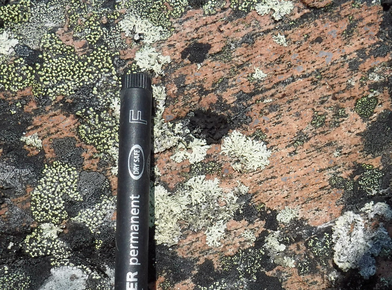
Mapping at scale 1:100 000 of the Sirmiq Lake area is a continuation of the field campaign conducted in 2017 in the Cape Wolstenholme area. The northern part of these two areas was interpreted as a Paleoproterozoic (1863-1800 Ma) magmatic arc, the Narsajuaq Arc. However, U-Pb zircon dating obtained from the 2017 work indicate a predominance of Archean rocks. Five crystallization ages ranging from 2800 Ma to 2550 Ma were obtained from different lithological units in the Cape Wolstenholme area, namely two hypersthene quartz diorites, one opdalite, one tonalitic gneiss and one monzogranite. Most of these lithologies were affected by granulite facies metamorphism between 1880 Ma and 1806 Ma. They extend eastwards into the study area. The Sirmiq Lake area also includes gabbro, tonalite, quartz monzonite and syenite units, as well as migmatized metasedimentary rocks and granulitic gneiss.
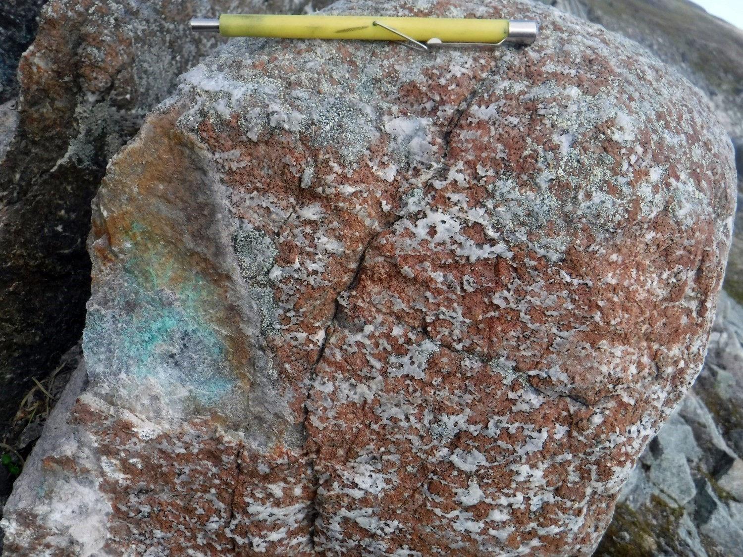
The mapping work also allowed identifying hydrothermal alteration zones possibly attributed to an iron oxide copper gold (IOCG)-type metallogenic context. Recognized alterations are: 1) K-feldspar-biotite-quartz-magnetite; and 2) quartz-plagioclase-biotite-chalcopyrite garnetite. These alteration zones are also spatially associated with the presence of regional lake bottom sediment anomalies in gold and copper.
Methodology
The area was mapped using the established methodology for surveys conducted in isolated areas without road access. The geological mapping work was carried out by a team of two geologists, a junior engineer, an engineering candidate and three students between 11 June and 4 September 2019. The mapping and synthesis of the Sirmiq Lake area produced and updated the information presented in the table to the right:
| Element | Number |
|---|---|
| Described outcrop (“geofiche”) | 609 outcrops |
| Total lithogeochemical analysis | 257 samples |
| Lithogeochemical analysis of metals of economic interest | 94 samples |
| Geochronological analysis | 10 samples |
| Covered thin section | 253 |
| Polished thin section | 21 |
| Sodium cobaltinitrite stain | 189 |
| Stratigraphic unit | 22 |
| Structural unit | 10 |
| Mineralization record | 8 |
Previous Work
The table below lists the work that has been done in the study area since 1960. It also includes references cited in the report. An exhaustive list can be found in the EXAMINE documentary database.
| Author(s) | Type of Work | Contribution |
|---|---|---|
| Kretz, 1960 | Mapping of the northern part of New Quebec | First geological map in the study area |
| Taylor, 1982 | Geological reconnaissance of the northern Ungava Peninsula | New geological map and description of geological units |
| Hoffman, 1985 | Synthesis and interpretation of geophysical data | Conceptualization of a tectonic model |
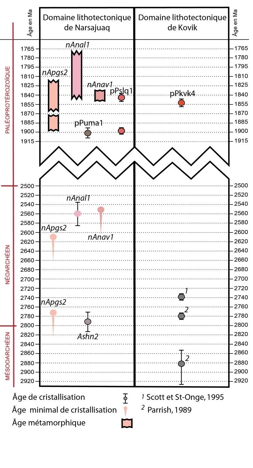
| Parrish, 1989 | Geochronology of the Ungava Orogen | U-Pb dating in the Narsajuaq and Kovik domains |
| Regional syntheses and interpretations | Structural, tectonic and metamorphic evolution; geodynamic evolution | |
|
Monday, 1994; |
Structural and metamorphic studies | Chronology of deformation and metamorphic events; quantification of metamorphic conditions |
| Trépanier, 2001 | Evaluation of the Zn-Pb-Cu potential | Discovery of a Cu-Ni mineralized zone |
| Regional Syntheses of the Trans-Hudsonian Orogen | Regional geodynamic models and correlations between the different domains | |
| Maurice and Lamothe, 2012 | Sediment geochemical surveys in the extreme Northern Quebec | Location of areas with economic potential |
| Baragar, 2015 | Mapping of Kovik Bay | Characterization of lithostratigraphic units and interpretation of lithological contacts |
| Charette and Beaudette, 2018 | Mapping of the Cape Wolstenholme area | Characterizing lithostratigraphic units and geological contacts |
Lithostratigraphy
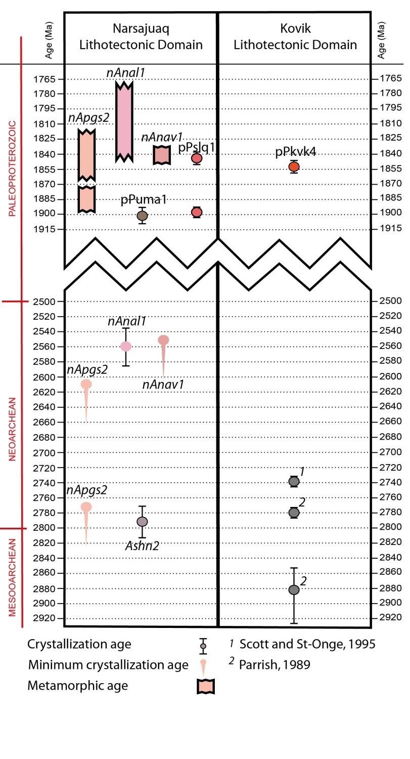
The Sirmiq Lake area is located in the Ungava Orogen, which is part of the Churchill Province. The geology is described as a package of Archean and Paleoproterozoic rocks remobilized in the Paleoproterozoic. In the northern part of the Ungava Orogen, two lithotectonic assemblages were recognized during previous work: the Narsajuaq Arc in the north and the Kovik Antiform in the south. These two entities are here renamed as distinct lithotectonic domains bounded by the Sugluk Shear Zone. Similar to observations in the Cape Wolstenholme area (Charette and Beaudette, 2018), this boundary has been shifted northward in the Sirmiq Lake area. The Narsajuaq Domain was amalgamated with the Superior Craton during the Ungava Orogenesis (Hoffman, 1985; St-Onge et al., 1992a). According to these conceptual models, the Superior Craton would be represented in the area by the Kovik Lithotectonic Domain.
The following section provides a summary description of lithostratigraphic units in the Sirmiq Lake area. They are presented according to their relative chronology. A more detailed description is available in the Stratigraphic Lexicon using the hyperlinks inserted below.
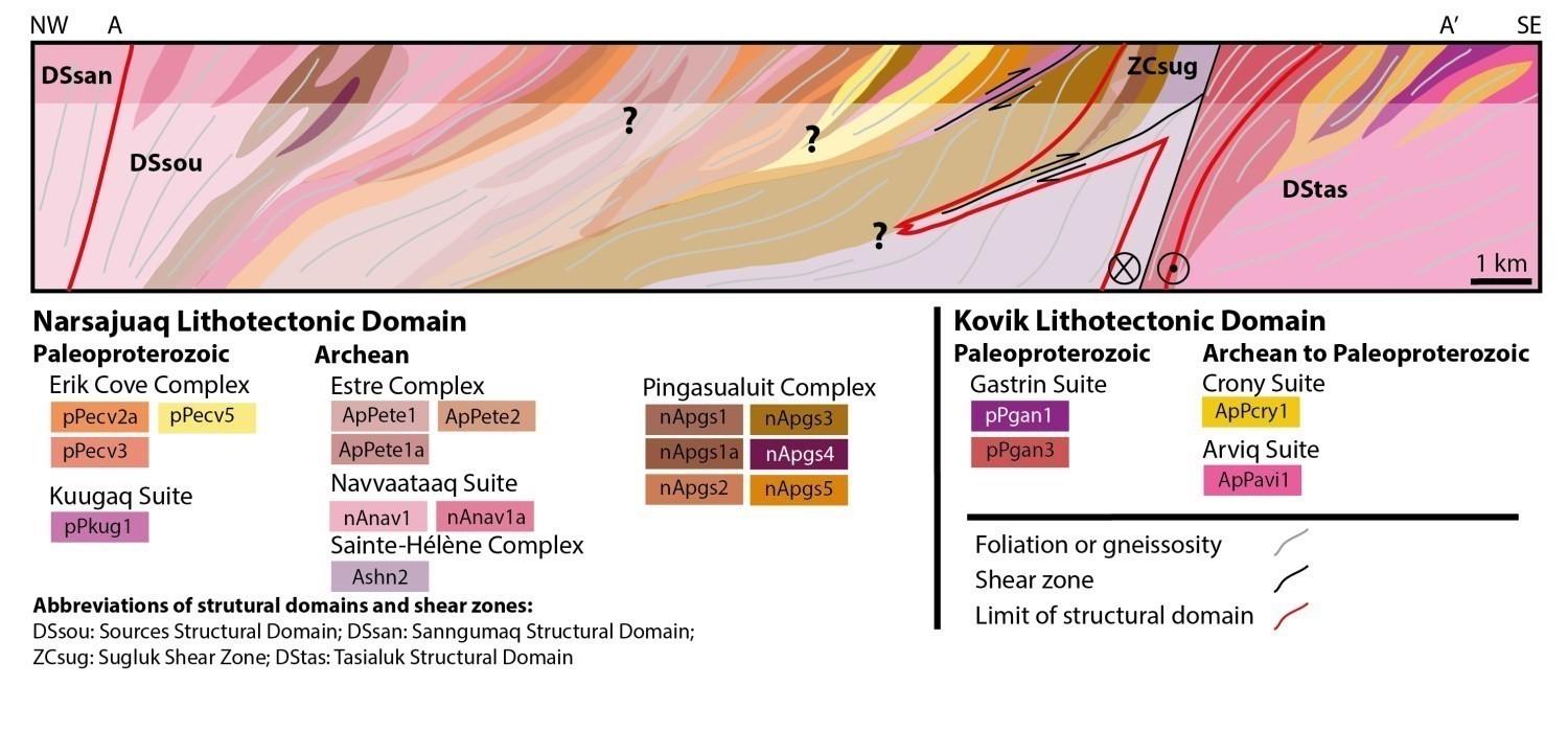
Narsajuaq Lithotectonic Domain
The Narsajuaq Domain covers nearly 85% of the study area. All of the units were affected by intense penetrative deformation and granulite to upper amphibolite facies metamorphism that mask initial relationships. Thus, the majority of contacts between units are tectonized. In the Sirmiq Lake Area, the Sainte-Hélène, Estre and Pingasualuit complexes represent the oldest rocks. These different units form imbricate klippes that alternate on a hectometric to kilometric scale.
The Sainte-Hélène Complex (Ashn; 2794 ±21 Ma; Davis and Sutcliffe, 2018)) is concentrated within an ovoid structural dome ~24 km by 12 km. It consists of tonalitic to quartzodioritic gneiss variably migmatized in transitional contact. Gneiss units located north of the Naujaat Shear Zone, previously assigned to this complex by Charette and Beaudette (2018), gave a Paleoproterozoic emplacement age (1901 ±8 Ma; Davis and Sutcliffe, 2018), which led to the definition of a new unit, the Uummanaq Suite (pPuma).
The Estre Complex (ApPete) is a new unit introduced in order to group felsic to intermediate granulitic orthogneiss of the Narsajuaq Domain. This type of rock is uncommon in the Cape Wolstenholme area. Charette and Beaudette (2018) had grouped these gneiss layers in the Pingasualuit Complex. The granulitic gneiss unit of uncertain origin defined by these authors was reassigned to the Estre Complex. It is possible, however, that in their work area, small amounts of granulitic gneiss similar to that of the Estre Complex are still present in the unit of intermediate composition of the Pingasualuit Complex (nApgs2).
The Pingasualuit Complex (nApgs) is the most abundant unit in the study area and groups mafic, intermediate and ultramafic intrusive rocks of the Narsajuaq Domain. Two samples of hypersthene quartz diorite collected in this unit by Charette and Beaudette (2018) yielded minimum Neoarchean emplacement ages (2773 Ma and 2609 Ma; Davis and Sutcliffe, 2018). Within mafic rocks, different phases could be differentiated in the Sirmiq Lake area, contrary to the gabbro and gabbronorite unit (pgs1) present in the Cape Wolstenholme area, which groups several phases in the same unit (Charette and Beaudette, 2018). Among others, there is a unit of coarser-grained speckled gabbro and gabbronorite.
The Sirmiq Lake area also includes numerous klippes of metatexite and diatexite derived from the partial melting of metasedimentary rocks assigned to the Erik Cove Complex (pPecv). Quartzite sequences have also been observed.
In addition to being interstratified, the Sainte-Hélène, Estre, Pingasualuit and Erik Cove complexes described above are intruded by enderbite of the Navvaataaq Suite (nAnav). Field relationships and its age (2560 ±26 Ma; Davis and Sutcliffe, 2018) indicate that this suite is late compared to these complexes. This unit, which can include up to 20% diffuse leucosome, appears to have been more highly migmatized in the study area than in the area directly west, where it was defined (Charette and Beaudette, 2018). Foliated to gneissic granite of the Kuugaq Suite (pPkug) forms elongated kilometric klippes commonly located along shear zones. Its age of emplacement is uncertain and it cannot be excluded that it is Archean.
Although it is mostly composed of Archean rocks, the Narsajuaq Domain also contains a few intrusive rocks of Paleoproterozoic suites. In the study area, the most important of these is the Fargues Suite (ApPfag), consisting mainly of syenite and monzonite containing orthopyroxene locally. Feldspar porphyritic intermediate intrusive rocks of the Frichet Suite (pPfri) are restricted to the SW end of the study area, in the extension of units of the Cape Wolstenholme area (Charette and Beaudette, 2018).
Rare klippes of speckled or porphyraceous quartz monzodiorite have been assigned to the Suluraaq Suite (pPslq). Two samples collected by Charette and Beaudette (2018) in this unit yielded Paleoproterozoic emplacement ages (1889 ±4 Ma and 1844 ±6 Ma; Davis and Sutcliffe, 2018). Finally, the Sanningajualuk and Ivitaruq suites are the youngest units of the Narsajuaq Domain since they cut all the other units. These two coarse-grained suites have not been observed much in the study area. The first consists of pink granite and the second of monzodiorite and monzonite.
Kovik Lithotectonic Domain
Outside the study area, units of the Kovik Lithotectonic Domain are assigned to the Kovik Complex. They will be gradually reassigned to separate suites. For the moment, it has not been possible to correlate units observed during this work with those in the Cape Wolstenholme area (Charette and Beaudette, 2018). A sample collected by Charette and Beaudette (2018) from a homogeneous tonalite yielded a Paleoproterozoic age of 1852 ±6 Ma (Davis and Sutcliffe, 2018). Three Archean ages (2882-2737 Ma) were also obtained by Parrish (1989) and Scott and St-Onge (1995) from tonalite samples collected in the Kovik Domain.
In the Sirmiq Lake area, the Nanuk Complex (ApPnuk) is the oldest unit of the Kovik Domain. It consists of tonalite and gneissic quartz diorite, as well as migmatite derived from their partial melting. The complex is locally cut by granodiorite of the Arviq Suite (ApPavi). Hectometric to kilometric klippes of migmatized metasedimentary rocks of the Crony Suite (ApPcry) were also observed in tectonized contact with the Nanuk Complex and Arviq Suite.
Primary contacts between intermediate to ultramafic intrusive rocks of the Gastrin Suite (ApPgan) and surrounding rocks have also been obliterated. However, a preliminary Paleoproterozoic age (Davis and Sutcliffe, in preparation) indicates that this is probably one of the youngest units in the Kovik Domain. Finally, granite of the Nunatak Suite (pPnat) is also clearly Paleoproterozoic in age as it intrudes into all the other units of the domain, including the Gastrin Suite.
Lithogeochemistry
The lithogeochemistry of units in the Sirmiq Lake area is presented separately in tabular form.
Structural Geology
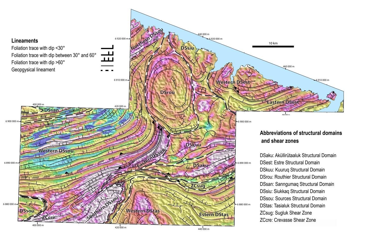
The study area was divided into eight structural domains:
- Sources Structural Domain (DSsou);
- Sanngumaq Structural Domain (DSsan);
- Routhier Structural Domain (DSrou);
- Siukkaq Structural Domain (DSsiu);
- Kuuruq Structural Domain (DSkuu);
- Estre Structural Domain (DSest);
- Aküllirütaaluk Structural Domain (DSaku);
- Tasialuk Structural Domain (DStas).
The study area also includes two shear zones:
- Crevasse Shear Zone (ZCcre);
- Sugluk Shear Zone (ZCsug).
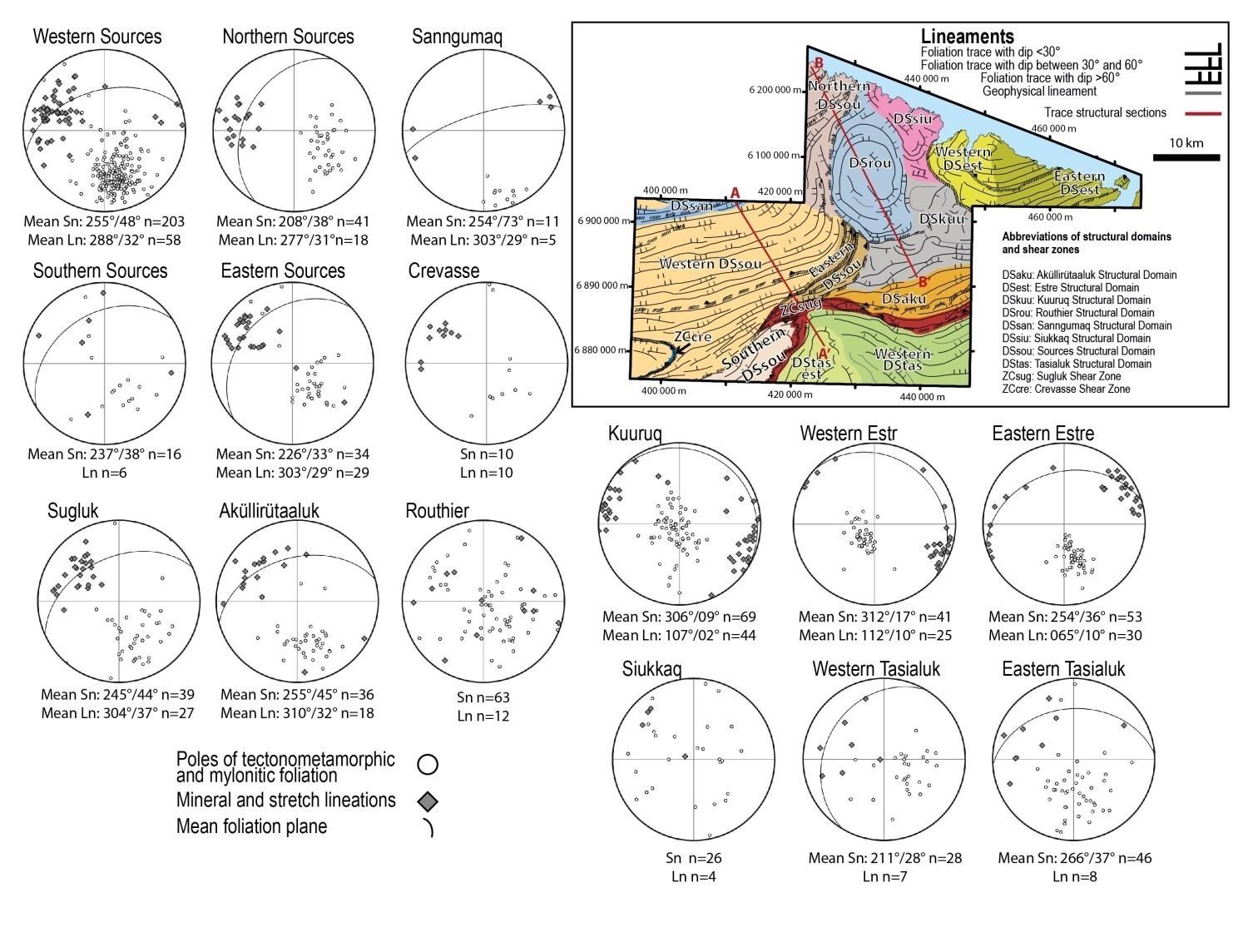
These structural domains were individualized on the basis of geophysical lineaments, which correspond to foliation traces, the attitude of planar and linear fabrics and the expressed deformation style. Rocks are characterized by penetrative deformation which is expressed by a well-developed tectonometamorphic foliation parallel to compositional banding and lithological contacts. In the absence of evidence indicating a superposition of fabrics, all the structures in the same area are labelled Sn and Ln.
It is likely that all of these fabrics are linked to the same tectonic event, which is expressed by structural styles varying between domains. These are mainly represented by the presence of moderately dipping homoclinal zones, a dome, shear zones, and zones having subhorizontal fabrics.
Due to the location of the work, the structural evolution of the Kovik Domain is relatively poorly understood and cannot be correlated with that of the Narsajuaq Domain.
The Sugluk (ZCsug) and Crevasse (ZCcre) shear zones, as well as the Sources (DSsou) and Aküllirütaaluk (DSaku) structural domains are characterized by a thrust movement with a dextral component in ductile condition. The attitude of foliations and mineral and stretch lineations in these domains varies little. Foliations are generally oriented SW to W and have a dip of ~45°. The orientation of lineations approximately follows the slope line with a dip of 30° to 35° and a direction in the NW quadrant. The movements observed in the eastern DSsou and in the Crevasse and Sugluk shear zones are reverse with a dextral oblique component, indicating southward thrusting. Although this kinematics is not as well expressed in the western part of the DSsou and in the DSaku, a thrust movement is also interpreted there due to the continuity of structures. Deformation associated with the strike-slip component is concentrated in a few subvertical shear zones. The northern segment of the ZCcre is the best example of this phenomenon. There is a subhorizontal stretch lineation contained in a subvertical mylonitic foliation which is associated with sinistral strike-slip. Foliation in the southern segment of the ZCcre is inclined at almost 45° in a W to NNW orientation. Kinematics observed are of reverse movement with a dextral component. The geometry and kinematics of these two segments can be explained by thrusting towards the SE of the block bounded by the ZCcre. The Sanngumaq Domain is also attributed to the concentration of the offset component in subvertical structures.
The Estre Structural Domain (DSest) shares several characteristics with the DSsou, although it is not adjacent to it. The main deformation of the DSest can be correlated with the dextral thrusting phase described in the DSsou. The orientation of the foliation in the eastern part of the DSest is similar to that of DSsou. A reverse shear zone also crosses this area of the domain. However, with the exception of the shear zone, stretch and mineral lineations there are subhorizontal and may not indicate the orientation of regional shearing. The divergence between the stretch lineation and the shear orientation is possible in the context of sub-simple shearing and deviation from planar deformation (Fossen and Cavalcante, 2017).
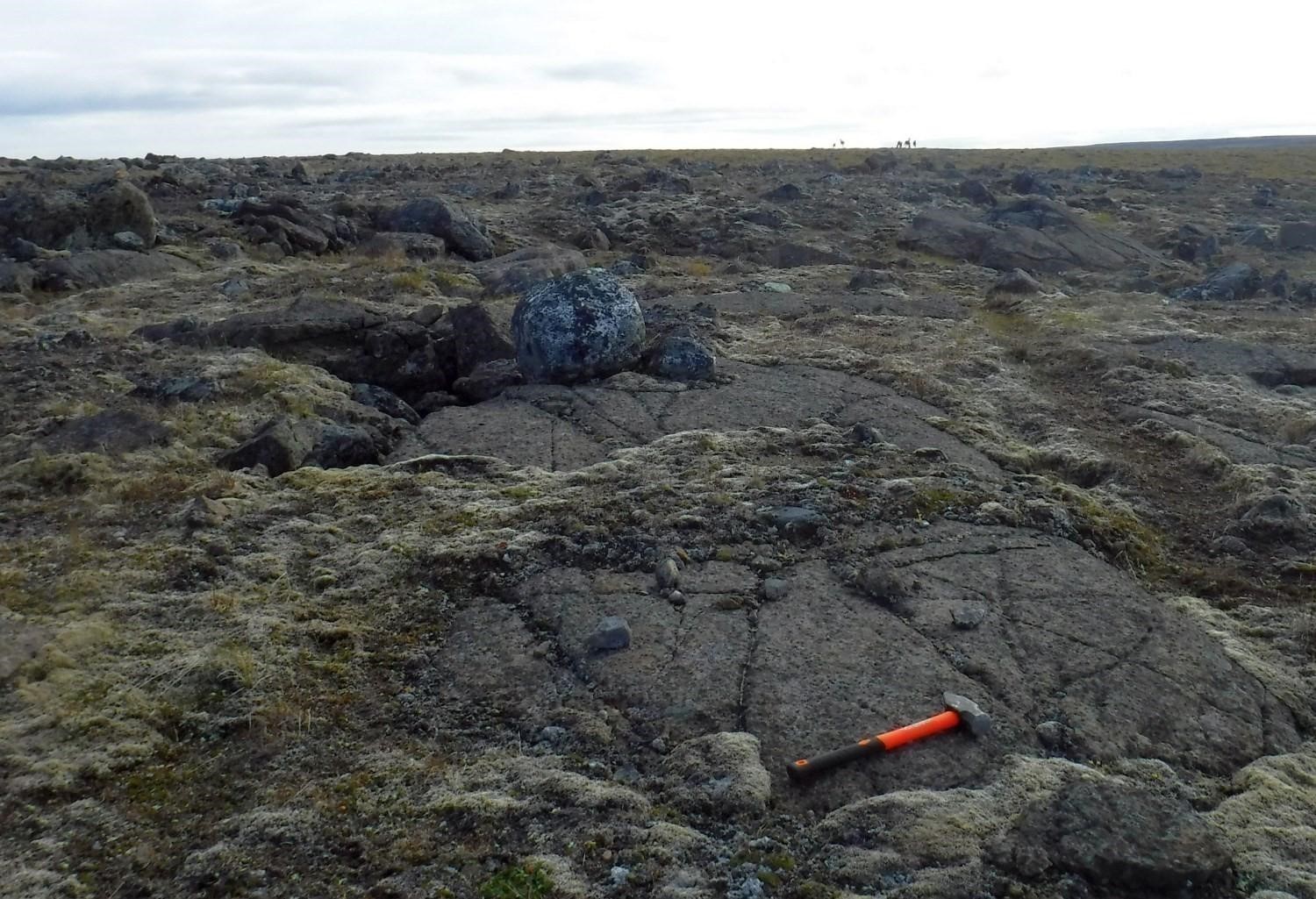
Several outcrops to the north of the ZCsug display stromatic banding parallel to the tectonometamorphic foliation. In addition, quartz grains in these leucosomes are commonly lenticular in shape, indicating that the main deformation started during partial melting and continued after crystallization of the anatectic liquid.
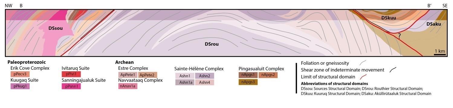
The Routhier Domain (DSrou) is characterized by a domed geometry. On aeromagnetic maps, the boundary of this domain with the Kuuruq Domain (DSkuu) is essentially diffuse. The DSkuu is characterized by subhorizontal planar fabrics and a mineral and stretch lineation oriented WNW-ESE on average. It is bounded to the west and NW by shear zones of the DSsou corresponding to important geophysical lineaments. Relationships between the DSsou homoclinal zone, the DSrou dome and the DSkuu subhorizontal zone remain unclear. Structures of the DSsou are gradually curving into those of the DSrou, while the DSsou seems to overthrust the DSkuu. There is no evidence that the main fabrics in these structural domains originate from distinct deformation phases. Rather, it would be a main deformation affecting all the structural domains of the Narsajuaq Lithotectonic Domain and caused by a phase of convergence along a ~NNW-SSE axis. Variations in structural styles reflect the anisotropy of the middle to lower crust, the partitioning of deformation and the progressive accumulation of deformation.
Metamorphism
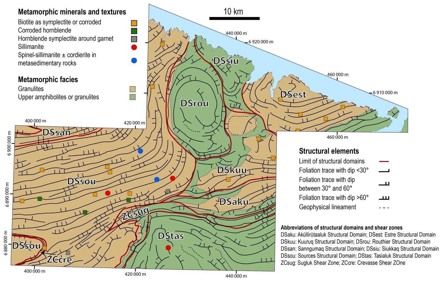
The Narsajuaq Domain presents several characteristics of the granulite metamorphic facies and the reaching of anatexis conditions. Mineralogical assemblages and metamorphic textures of the main units in the study area (Estre, Pingasualuit and Erik Cove complexes and Navvaataaq Suite) are compiled on the metamorphic map. Orthopyroxene is a mineral phase characteristic of this lithotectonic domain. In addition, biotite structures commonly display corrosion and disequilibrium with orthopyroxene, supporting a metamorphic origin of the latter through dehydration of biotite, producing orthopyroxene and anatectic fluid. This reaction, which is highly temperature-dependent, occurs at around 850°C in metasedimentary protoliths (Spear et al., 1999).
Biotite is observed as symplectites with quartz, often in the vicinity of orthopyroxene. These symplectites are interpreted as the result of the final crystallization of minor volumes of anatectic liquid in a residual rock. Orthopyroxene of the metamorphic peak assemblage is then destabilized and partially resorbed to form biotite-quartz symplectites. The common reaction for this phenomenon (liquid + orthopyroxene + garnet + K-feldspar = biotite + quartz) essentially represents the reverse reaction of the prograde metamorphic pathway allowing the formation of orthopyroxene (Sawyer, 2008). The location of samples showing biotite corroded or as symplectites with quartz is indicated on the metamorphic map. Their distribution reflects granitic conditions over most of the mapped area, particularly in the western part.
Sedimentary protoliths of the Erik Cove Complex show the most diverse metamorphic assemblages. Three main assemblages have been identified. Firstly, the most common assemblage (plagioclase-quartz-K-feldspar-orthopyroxene-garnet-biotite-ilmenite-liquid) corresponds to that of a metasedimentary rock reaching the granulite facies. Sillimanite can then be added to the previous assemblage. Finally, two samples are free of orthopyroxene and instead contain sillimanite and spinel and/or cordierite which form symplectites with garnet. These variations are probably due to different protolith compositions and each assemblage is compatible with the granulite facies.
On outcrops, mafic rocks of the Pingasualuit Complex commonly display leucosomes containing garnet or clinopyroxene, the latter appearing to be peritectic phases. The clinopyroxene-hornblende-plagioclase-orthopyroxene-garnet ± biotite metamorphic assemblage also corresponds to the granulite facies. Hornblende forms euhedral grains replacing pyroxene or rimming it. More locally, it is corroded in irregular form and strewn with rounded inclusions in optical continuity which are interpreted as pseudomorphs of anatectic liquid. Garnet is porphyroblastic and locally replaced by plagioclase-hornblende symplectites. Given the pyroxene retrogression also observed in these samples, it is possible that symplectites were originally composed of orthopyroxene or clinopyroxene. These symplectites are known to indicate isothermal decompression (e.g. Groppo et al., 2007).
The Sainte-Hélène Complex differs from other dominant units of the Narsajuaq Domain in that it is practically free of orthopyroxene. Nonetheless, it appears to be commonly migmatized on outcrops, indicating a metamorphic grade at least equivalent to the upper amphibolite facies. Moreover, the presence of sparse relics of orthopyroxene in the core of hornblende indicates that the granulite facies was reached locally.
In general, in the study area, the western part of the Narsajuaq Domain has reached the granulite facies. The most conclusive evidence is the intersection of the dehydration reaction of orthopyroxene-forming biotite and anatectic liquid. High-pressure conditions do not seem to have been reached since the presence of sillimanite and the absence of kyanite are observed.
For now, metamorphic characteristics of the Kovik Domain remain poorly defined. The occurrence of migmatites in the Nanuk Complex and sillimanite in the Crony Suite support metamorphism equivalent to or higher than the upper amphibolite facies.
Economic Geology
The Lake Sirmiq region presents prospective zones for six types of mineralization:
- Ni-Cu-PGE or Cr mineralization associated with ultramafic intrusions;
- Cu-Au mineralization associated with hydrothermal alteration zones;
- Fe-Ti-V mineralization associated with mafic intrusions;
- Mineralization in iron formations;
- Rare metal mineralization associated with hyperalkaline rocks;
- Polymetallic mineralization associated with metasedimentary rocks.
The table of mineralized zones below presents analytical results for the nine known mineralized zones in the area, including seven mineralized zones discovered during our work and two known mineralized zones.
Mineralized Zones in the Sirmiq Lake Area
| Name | Contents | Comments |
|---|---|---|
| Mineralization in Iron Formations | ||
| Cobin | 372 920.08 ppm Fe (G) | |
| Derville | 443 699 ppm Fe (G) | |
| Derville-Est | 402 854.4 ppm Fe (G) | |
| Sirmiq | 406 351.4 ppm Fe (G) | |
| Sirmiq-Est | 333 682.74 ppm Fe (G) | |
| Sirmiq-NE | 336 061.6 ppm Fe (G) | |
| Sirmiq-Sud | 360 191 ppm Fe (G) | |
| Name | Contents | Comments |
|---|---|---|
| Rare Metal Mineralization Associated with Hyperalkaline Rocks | ||
| Sanningajualuk | 7990 ppm Zr (G) | |
| Magmatic Mineralization, Ni-Cu dominating (± Co ± PGE) | ||
| ÉCH. 124767 | 975 ppb Pd (G); 6894 ppm Ni (G); 2163 ppm Cu (G); 397 ppb Pt (G); 365 ppb Au (G); 3580 ppm Cr (G) | |
(G): Selected sample
The table of lithogeochemical analyses of metals of economic interest provides the location, description, and analytical results for 94 samples selected to assess the economic potential of the area.
Known Mineralized Zones in the Study Area
New Showing Content of Platinum Group Elements on a Nickel Mineralized Zone
 Work in the summer of 2019 allowed the ÉCH. 124767 mineralized zone discovered in 2001 by Noranda Exploration (Trépanier, 2001) to be revisited. It was possible to relocate this Ni-Cu-PGE mineralized zone, hosted in olivine websterite of the Pingasualuit Complex (nApgs4), ~185 m north of the described position. A field check did not locate any ultramafic rocks at the coordinates indicated in the report. Noranda’s sample 124767, which had not been analyzed for PGEs, yielded contents of 0.7% Ni and 0.2% Cu. Two samples from outcrop 19-IL-3143 yielded showing contents for palladium (975 ppb Pd), anomalous gold (365 ppb Au), platinum (397 ppb Pt) and chromium (0.4% Cr). Mineralization consists of 5% to 12% pyrrhotite disseminated and in centimetric nodules associated with <1% chalcopyrite and pentlandite. Olivine websterite is in contact with migmatized paragneiss of the Erik Cove Complex to the south and gneiss of the Estre Complex to the north. The extension of this intrusion was also observed 3 km (19-IL-3120) and 5 km (19-JV-2087) to the east, where anomalous copper contents were obtained. The Platinic prospective zone corresponds to this intrusion.
Little-Known Mineralized Zones and Discoveries Made During the Present Work
Discovery of Ultramafic Intrusions with Potential for Cu-Ni or Cr ± Ni Mineralization

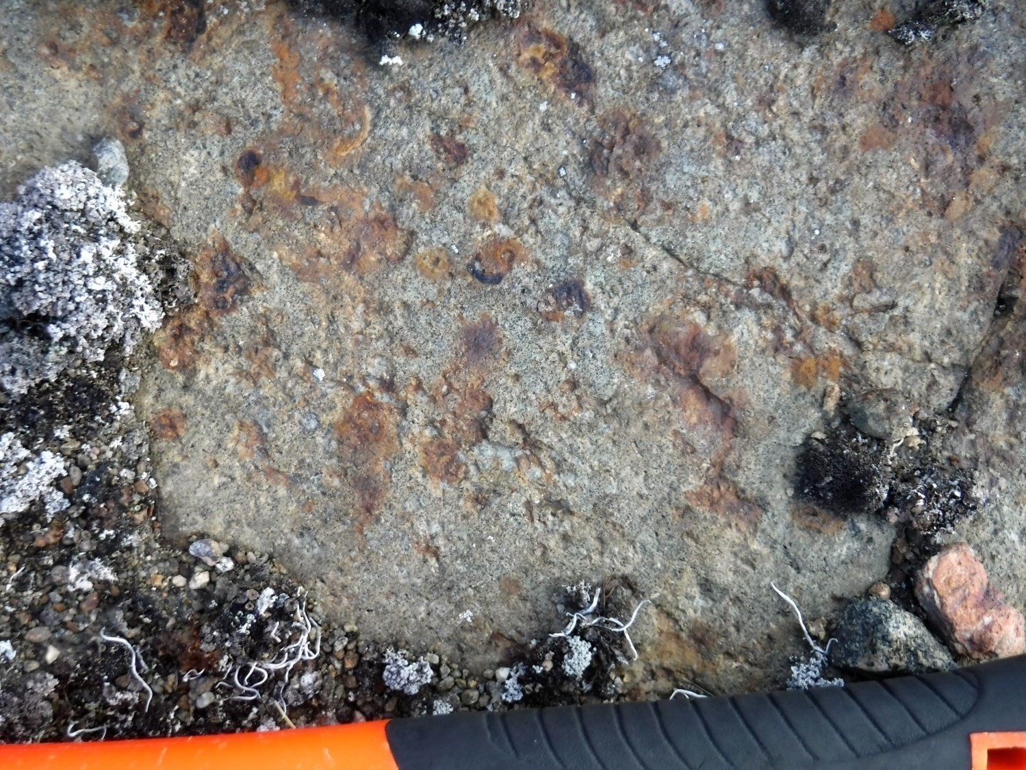
The Cupri prospective zone is associated with outcrops 19-IL-3056 and 19-IL-3057 and corresponds to a strong 4 km long aeromagnetic lineament. The olivine websterite outcrop is at least 350 m wide and is characterized by the common occurrence of malachite. A rusty zone containing 2% disseminated pyrrhotite and pyrite yielded anomalous copper contents (≤894 ppm Cu) in addition to significant nickel, chromium and gold contents.
In addition to being of interest for magmatic and hydrothermal Ni-Cu-PGE mineralization (Platinic and Cupri prospective zones), ultramafic intrusive rocks of the Pingasualuit Complex (nApgs4) also have potential for chromium mineralization. The Croma prospective zone contains four intrusions having anomalous chrome contents (0.32-0.39% Cr2O3). At Outcrop 19-IL-3006, olivine websterite is 70 m wide and spatially associated with a strong aeromagnetic lineament 3.7 km long. Thin-section samples of websterite, olivine websterite and lherzolite collected on outcrops 19-MV-1054, 19-IL-3175 and 19-MV-1097 are characterized by the occurrence of 1-3% spinel (green and brown), in addition to opaque minerals (magnetite and chromite) which can represent 10% of the rock locally.
Discovery of Large Hydrothermal Alteration Zones Associated with Lake Bottom Sediment Anomalies in Gold and Copper
Regional alteration zones associated with strong magnetic anomalies were mostly recognized within mafic and ultramafic intrusions of the Pingasualuit Complex (pgs3a). Two main alteration facies were observed and are presented as distinct prospective zones.
The Magnet prospective zone comprises two areas and includes a mostly potassic and ferriferous alteration. In the area of outcrops 19-IL-3165 and 19-IL-3166, two mineralogical assemblages are recognized: K-feldspar-magnetite-biotite-clinopyroxene ± garnet ± quartz and clinopyroxene-amphibole-carbonate-sulphides. These alteration zones alternate on a decimetric scale and affect gabbro and pyroxenite of the Pingasualuit Complex. Sulphides form millimetric to centimetric clusters in association with calcite and malachite.
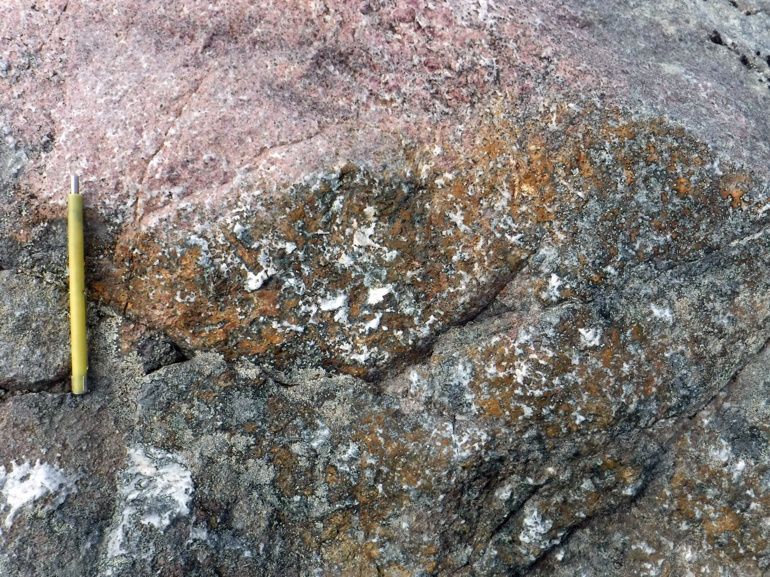

The Garnot prospective zone contains three areas characterized by the presence of quartz-plagioclase-biotite ± magnetite ± calcite ± chalcopyrite ± malachite ± azurite. These areas are spatially associated with the presence of regional lake bottom sediment anomalies in gold and copper (Maurice and Lamothe, 2012). Analytical results also indicate about 10 anomalous copper contents (≤2660 ppm Cu) as well as significant contents of gold, molybdenum, zinc, nickel, yttrium, thorium and iron. At outcrop 19-MV-1114, gabbro contains many metric zones of garnetite containing up to 1% disseminated chalcopyrite. Some of these zones are fractured and affected by supergene alteration that has resulted in malachite and azurite platings. Similar but smaller alteration zones also occur in the area of outcrop 19-IL-3186. At outcrop 19-IL-3094, a metric garnet-pyroxene layer contains disseminated carbonate veins and ~2% disseminated pyrite and pyrrhotite associated with traces of chalcopyrite. This layer is in contact with a decimetric albitite layer.
The presence of these high temperature K-Fe and low temperature Ca-Mg hydrothermal alteration zones could be interpreted as the product of the evolution of an iron oxide copper gold (IOCG) system.
Discovery of an Iron Formation More Than 40 km Long

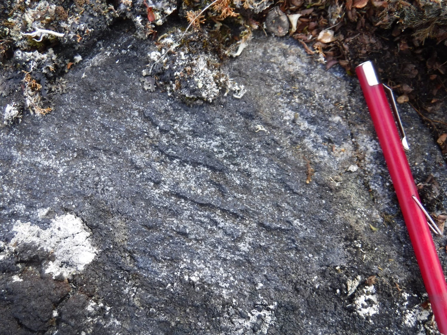

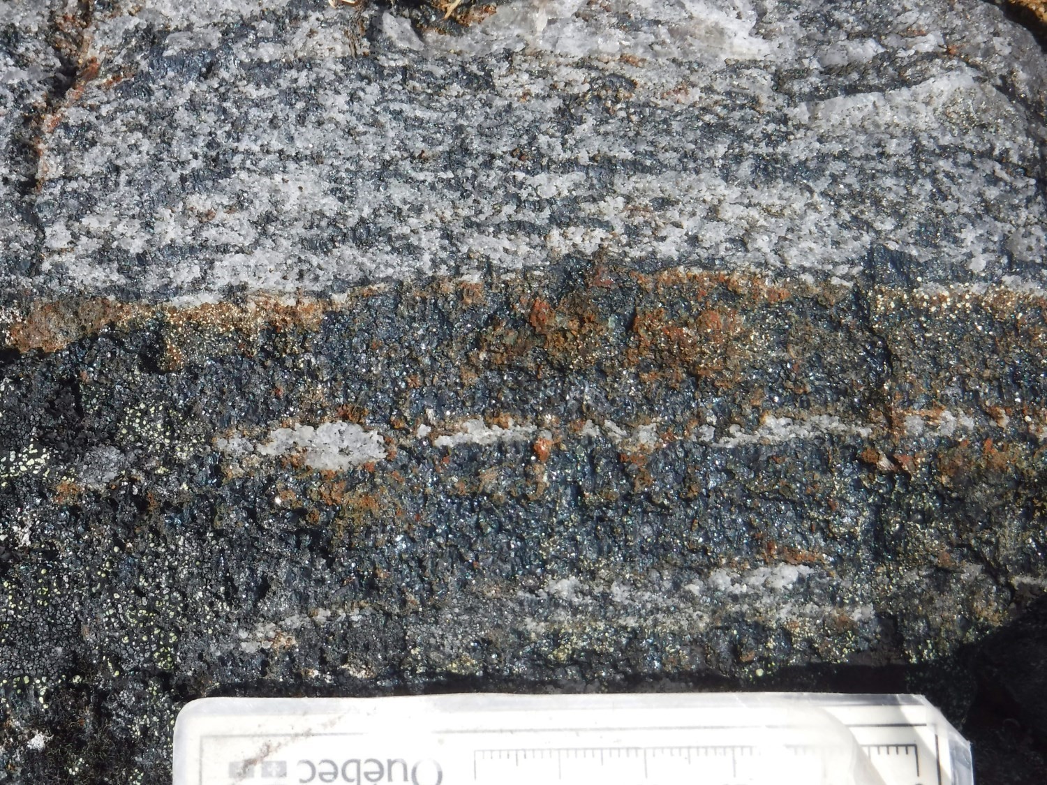
The Dôme de fer prospective zone comprises two distinct areas associated with positive aeromagnetic lineaments 100 m to 400 m wide. The first lineament is >40 km long; it is oriented ENE-WSW in the west and N-S in the east. It extends west of the Sirmiq Lake area (sheet 35K03). The second lineament is ~3.5 km long. It is located ~2 km SE of the first one and follows the same N-S orientation in this area. Iron formation layers associated with smaller aeromagnetic lineaments are also present further east near Hudson Strait. Several showing contents of iron have been obtained in seven mineralized zones (see table of mineralized zones).
On outcrops, the iron formation forms discontinuous klippes (1-60 m wide by 10 m to 1 km long) within enderbite of the Navvaataaq Suite, mafic intrusive rocks of the Pingasualuit Complex and granulitic gneiss of the Estre Complex. It was only seen in contact with migmatized paragneiss of the Erik Cove Complex at outcrop 19-IL-3135. Except for a few centimetric to decimetric bands of semi-massive magnetite, the general appearance is not banded. For these reasons, these areas were initially interpreted as part of a large iron alteration system potentially associated with the Garnot and Magnet prospective zones.
The lateral continuity of the unit, thin-section observations and geochemical analyses suggest instead that these are klippes of iron formation. The granoblastic structure observed under the microscope may explain the loss of primary banding. In addition, general geochemistry with an average SiO2 + Fe2O3 of ~97% and low contents for all other major elements indicates a similarity to that of Precambrian iron formations worldwide (Prasad et al., 2012 and references cited). The lack of enrichment in various metals (e.g. REE-Nb and Cu-Au-U-Ag-REE) also suggests that these magnetite-quartz zones are not connected to an IOCG system, recognized for these types of enrichment (Corriveau, 2006).
The composition of magnetite grains from four samples was analyzed at the electron microprobe to identify their metallogenic environment (Delobel, 2020). The use of this data is limited by the diffusion of magnetite’s trace elements during granulite facies metamorphism, therefore a hydrothermal or chemical precipitation origin appears more likely than magmatic origin.
Considered as iron formations, these rocks were assigned to the Erik Cove Complex. The main oxide facies is dominated by quartz and magnetite (>80%) which form elongated lenses or bands marking foliation. Centimetric to decimetric silicate facies layers also occur. In addition to magnetite, these may contain pyroxene, garnet, quartz, amphibole and olivine. Iron formation is locally rusted and in this case contains 1-8% disseminated sulphides and local graphite.
Discovery of Mafic Intrusions with Potential for Fe-Ti-V Mineralization
Pingasualuit Complex’s magnetite-ilmenite gabbronorite may have potential for magmatic mineralization in iron (<22.6% Fe2O3), titanium (<3% Ti) and vanadium (<615 ppm V). Significant contents of these elements were obtained from samples assigned to unit nApgs1b. This gabbronorite forms boudinaged layers or decimetric to decametric lenses within the Navvaataaq Suite and Estre Complex. The thickest layers were observed on outcrops 19-JV-2068, 19-IL-3142 and 19-IL-3147.
Discovery of Hyperalkaline Rocks with Potential for Rare Metals Mineralization
The occurrence of a 13 km by 6 km dominantly syenitic intrusive mass (Fargues Suite) in the southern part of the study area indicates potential for this type of mineralization. Significant contents of rare earth elements and zirconium were obtained in samples collected on outcrops 19-IL-3102 and 19-MV-1077.
Discovery of Rusted Zones Within Metasedimentary Units
Migmatized metasedimentary rocks of the Erik Cove Complex and Crony Suite, respectively in the Narsajuaq and Kovik lithotectonic domains, contain several decimetric to decametric rusted zones containing up to 5% disseminated sulphides, dominated by pyrite and pyrrhotite with traces of chalcopyrite. Some of these zones yielded anomalous or significant contents of copper, nickel, zinc, cobalt, molybdenum and graphitic carbon.
In the Erik Cove Complex, several of these rusted zones are associated with the occurrence of thin klippes of metamorphosed silicate facies iron formation (quartz-garnet-clinopyroxene-magnetite). At outcrop 19-IL-3073, a sample from one of the many rusted zones yielded an anomalous content of 1290 ppm Cu.
In the Crony Suite, rusted zones are characterized by the presence of millimetric graphite flakes (<10%) in paragneiss. They are also commonly located along lithological contacts and associated with pervasive silicification. Anomalous contents up to 790 ppm Cu (19-MV-1019) and 1.85% Cg (19-IL-3132) were obtained in this context.
Issues for Future Work
Mapping of granulitic terrains is a challenge in identifying protoliths, types of mineralization and stratigraphic relationships. Some rocks in the Lake Sirmiq area have mineralogy, structures, microstructures and a geological context that lead to incongruities at first glance. This is the case with the iron formation unit of the Erik Cove Complex, which forms thin klippes trapped in kilometric masses of igneous rock such as enderbite of the Navvaataaq Suite. The origin of garnetites hosted in mafic rocks of the Pingasualuit Complex is also difficult to identify. The hypothesis used is that of an IOCG-type hydrothermal system. Some components remain missing, such as hydrothermal brecciation zones and large volumes of rocks displaying sodic and potassic alteration.
In terms of stratigraphic relationships, the most problematic unit is the Erik Cove Complex, which consists of migmatized metasedimentary rocks. A quartzite from this complex contains, according to the work of Parish (1989), both detrital zircons dated 1830 Ma, and Archean zircons with metamorphic overgrowth formed in the Paleoproterozoic. He therefore indicates that the age of deposition is earlier, while mentioning that at ~1830 Ma, this sample is affected by regional granulite facies metamorphism. These results appear questionable given the short time between deposition of sediments and the episode of high-grade metamorphism. Detrital zircons may have been mistaken for metamorphic zircons. To clarify the age of deposition of metasedimentary rocks, analysis of sulphide isotopes was performed on ~10 samples (Bui et al., in preparation). Results demonstrate that at least one sample has a sulphide isotopic signature that is indicative of sediments deposited in the Archean. The others are inconclusive. Geochronological analysis of a quartzite sample collected in the summer of 2019 (pending) is expected to confirm the Erik Cove Complex’s age of deposition and produces a stratigraphic diagram for the Narsajuaq Lithotectonic Domain.
In terms of regional tectonics, our work reveals that the Narsajuaq Domain has several characteristics of so-called hot orogens (Chardon et al., 2009; Fossen et al., 2017): the occurrence of migmatization during deformation, a metamorphic peak estimated at ~850°C, penetrative ductile deformation and little spatial variation in metamorphic intensity. The mean crust of this type of orogen is thought to have a low viscosity and behave approximately as a fluid (Vanderhaeghe, 2009), preventing the piling of sheets vertically through highly focused shear zones. The pattern of deformation within warm orogens is more consistent with horizontal or vertical ductile flow (Beaumont et al., 2001; Chardon et al., 2009; Vanderhaeghe, 2009). Thus, the reverse movement observed in the mapped area is interpreted as SSE-oriented ductile flow within a middle to lower crust. The Routhier structural dome could be a sign of instability due to the contrast of buoyancy in a crust lacking continuous rigidity. Further work is needed to validate these interpretations and the relationship between the Narsajuaq and Kovik domains, which could represent the lower and medium crusts of the Ungava Orogen, respectively.
| Authors | Marc-Antoine Vanier, Jr. Eng., M.Sc. marc-antoine.vanier@mern.gouv.qc.ca Isabelle Lafrance, P. Geo., M.Sc. isabelle.lafrance@mern.gouv.qc.ca |
| Geochemistry | Fabien Solgadi, P. Geo., Ph.D. |
| Geophysics | Siham Benhamed, GIT, M.Sc. Rachid Intissar, P. Geo., M.Sc. |
| Potential assessment | Hanafi Hammouche, P. Geo., M.Sc. |
| Logistics | Marie Dussault, coordinator |
| Geomatics | Julie Sauvageau, geomatics technician |
| Template and content compliance | François Leclerc, P. Geo., Ph.D. |
| Coaching/mentoring and critical review | Benoit Charette, P. Geo., M.Sc. |
| English version | Céline Dupuis, P.Geo., Ph.D. |
| Organism | General direction of Géologie Québec, Ministère de l’Énergie et des Ressources naturelles, Government of Québec |
Acknowledgements:
This Geological Bulletin was made possible through the cooperation of many people who have been actively involved in the various stages of the project. We would like to thank geologist Julie Vallières, engineer candidate Thierry-Karl Gélinas, and students Ismaël Couture, Charles D’Amours and Félix-Jérôme Perron. As part of a bachelor’s thesis, Philippe Delobel provided important input on mineralized zones. We would like to acknowledge the excellent work of cook Paméla Fournier, nurse Madeleine Bourassa and camp man Richard Brunet. Field transport was provided by Héli-Inter. Pilot Michel Meunier and mechanics Cynthia Nubien and Esteban Lezana performed their work effectively and professionally.
References
Publications of the Government of Québec
BUI, T.H., HALVERSON, G., CHARETTE, B., In preparation. Analyses des isotopes de soufre des échantillons recueillis à l’été 2017 par Géologie Québec lors du projet de cartographie géologique de l’Orogène de l’Ungava (Province de Churchill). Ministère de l’Énergie et des Ressources naturelles, in collaboration with McGill University, Québec.
CHARETTE, B., BEAUDETTE, M. 2018. Géologie de la région du cap Wolstenholme, Orogène de l’Ungava, Province de Churchill, sud-est d’Ivujivik, Québec, Canada. MERN. BG 2018-03, 2 plans.
DAVIS, D W., SUTCLIFFE, C.N. 2018. U-Pb Geochronology of Zircon and Monazite by LA-ICPMS in Samples from Northern Quebec. University of Toronto. MB 2019-01, 113 pages.
DAVIS, D W., SUTCLIFFE, C.N. 2020. U-Pb Geochronology of Zircon and Monazite by LA-ICPMS in Samples from Northern Quebec. University of Toronto. In preparation.
MAURICE, C., LAMOTHE, D. 2012. Nouveau levé géochimique de sédiments de lac dans l’extrême nord du Québec. MRNF. PRO 2012-03, 10 pages.
Other Publications