


Potential for volcanogenic massive sulphide mineralization in the Laporte Supersuite
Potential for polymetallic mineralization in claystones of the Freneuse Suite

Potential for rare metal mineralization in the Préville Suite
Potential for Cr-Ni mineralization in ultramafic intrusions of the Klein Suite
The Southeastern Churchill Province (SEPC) synthesis has identified the boundaries of the Rachel-Laporte Lithotectonic Domain. A geological map and stratigraphic diagram of this domain is presented in this bulletin. The Rachel-Laporte Domain consists mainly of Laporte Supersuite metasedimentary rocks and mafic intrusive and effusive rocks that have long been considered to be more metamorphosed stratigraphic equivalents of the rocks of the Kaniapiscau Supergroup (Labrador Trough). However, recent detrital geochronology work indicates different sources and depositional contexts for the sedimentary basins of the two lithotectonic domains. The Rachel-Laporte Domain is also characterized by the presence of tectonic slices of bedrock that overlapped Laporte Supersuite units during the New Quebec Orogenesis.
The Rachel-Laporte Domain is prospective for volcanogenic massive sulphide mineralization in sedimentary settings, polymetallic mineralization in claystones, chromium mineralization in ultramafic intrusions and rare metal mineralization in carbonate rocks of the Préville Suite.
Methodology
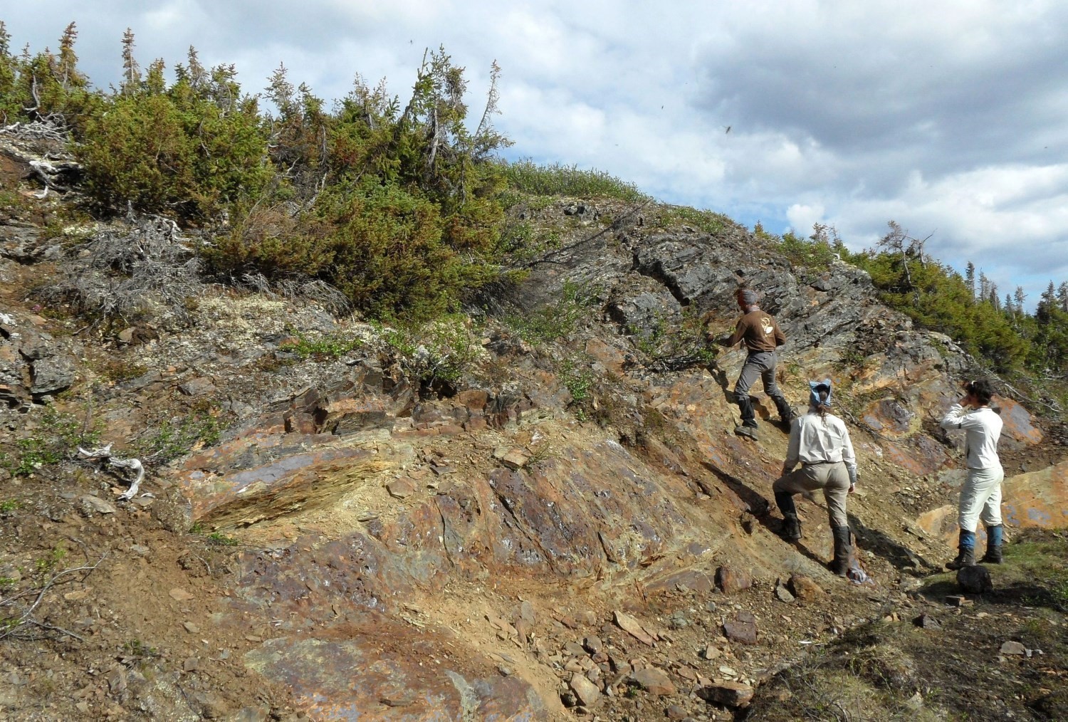
The Rachel-Laporte lithotectonic Domain was mapped using the established method for surveys in isolated areas without road access.
Geological mapping at scale 1:250 000 covering the entire domain was carried out by teams of seven to eight geologists and eight students in the summers of 2011, 2012 and 2015. Field checks were also carried out in the southern part of the domain in the summer of 2016 by a team of four geologists and three students. The Ministère‘s previous mapping work in the southern part of the domain was also taken into account in the processing of the data, including that of the summer of 2009.
The mapping and synthesis of the Baleine Domain have produced and updated information presented in the opposite table.
| Element | Number |
|---|---|
| Described outcrop (“geofiche”) | 2594 |
| Total lithogeochemical analysis | 336 |
| Lithogeochemical analysis of metals of economic interest | 212 |
| Geochronological analysis | 13 |
| Covered thin section | 254 |
| Polished thin section | 41 |
| Sodium cobaltinitrite stain | 18 |
| Stratigraphic unit | 15 |
| Metallic mineralization record | 8 |
| Non-metallic mineralization record | 1 |
Previous Work
The table below provides a list of works carried out in the study area since 1896. It also includes the references cited in the report.
| Auhor(s) | Type of Work | Contribution |
|---|---|---|
| Low, 1896; Bell and Low, 1900 | Geological survey | Initial geological survey work in the Southeastern Churchill Province |
| Fahrig, 1965 | Regional geological mapping at scale 1:250 000 | Annotated map of sheet 24F |
| Geological mapping at scale 1:50 000 | Geology of the Labrador Trough and its eastern boundary: sheets 23O, 23P, 24B, 24F and 24K. Correlations between units of the Labrador Trough and Rachel-Laporte Domain. | |
| Geological mapping at scale 1:250 000 | Geology of sheets 23O, 23P, 24B, 24F and 24K. | |
|
Gélinas, 1956; Sauvé, 1957b; Ferguson, 1958; Bérard, 1959; Moorhead and Hynes, 1990 |
Structural, stratigraphic and metamorphic studies | Shear zone analyses; metamorphic modelling; unit description and stratigraphy; stratigraphic correlations and geochronology |
| Fournier, 1985 | Metallogenic, stratigraphic and structural study | Description of mineralized sites, lithological units and correlations with the Labrador Trough |
|
Bardoux et al., 1988; Poirier et al., 1990 Wardle et al., 1990a; b; Wardle et al., 2002; James and Mahoney, 1994; Kerr et al., 1994 |
Compilation, geological synthesis, lithotectonic divisions and geodynamic implications |
Context and geotectonic evolution of the SECP |
| Geochronology, synthesis and lithotectonic divisions | U-Pb dating in the Rachel-Laporte Domain in Quebec: Freneuse Suite, Giton, Boullé, Highfall, Boulder and Rénia complexes | |
| Geophysical surveys | Aerial magnetic and spectrometric surveys covering the Rachel-Laporte Domain |
Stratigraphy
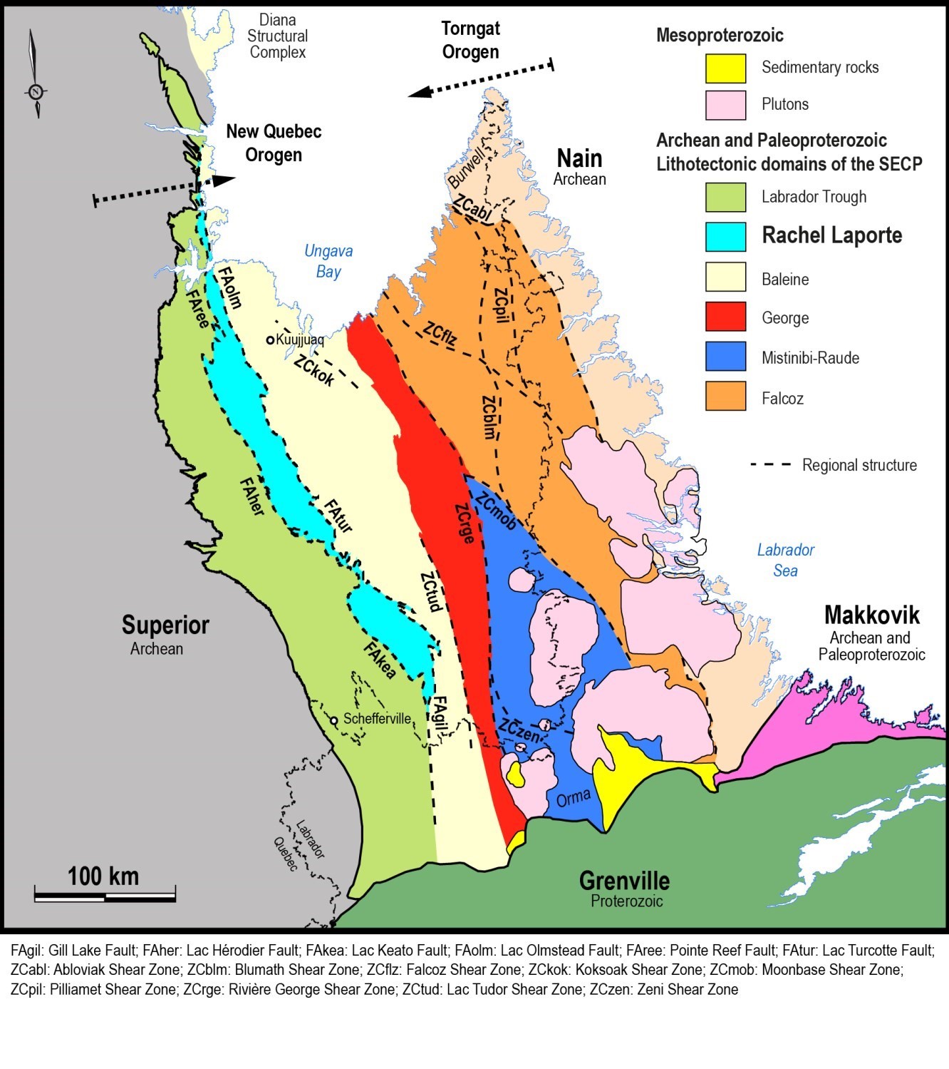
The Rachel-Laporte Lithotectonic Domain is located in the western part of the Southeastern Churchill Province (SECP). It consists mostly of metasedimentary rocks and mafic intrusive and effusive rocks belonging to the Laporte Supersuite. These rocks have long been considered to be more metamorphosed stratigraphic equivalents of those of the Kaniapiscau Supergroup, located in the Labrador Trough just to the west (Harrison, 1952; Gélinas, 1958a, b; Sauvé and Bergeron, 1965; Girard, 1995; Simard et al., 2013). However, significant differences between the detrital zircon populations of these two lithotectonic domains indicate different sources (Henrique-Pinto et al., 2017; Godet et al., 2020), confirming the hypothesis of Charette et al. (2016), who questioned this equivalence based on the apparent thickness and composition of metasedimentary rocks of the two domains. The age distribution of detrital zircons recovered from the Freneuse Suite ranges from 3226 to 1830 Ma (Henrique-Pinto et al., 2017; Godet et al., 2020) and includes Paleoproterozoic and Archean population peaks that are interpreted to indicate provenance from different lithotectonic domains of the SECP, namely the George, Baleine and Mistinibi-Raude domains (Henrique-Pinto et al., 2017, 2019). The source of the Kaniapiscau Supergroup sediments is thought to be the Superior Province, as all detrital zircons are Archean (Henrique-Pinto et al., 2017, 2019).
The eastern contact with the Baleine Domain was redefined by Lafrance et al. (2020) and corresponds to the presence of Archean gneiss not associated with a tectonic slice. In addition, units of the Baleine Domain were strongly affected by migmatization that produced significant amounts of anatectic fluid, whereas within the Rachel-Laporte Domain, indications of partial melting are minor and located at the eastern edge.
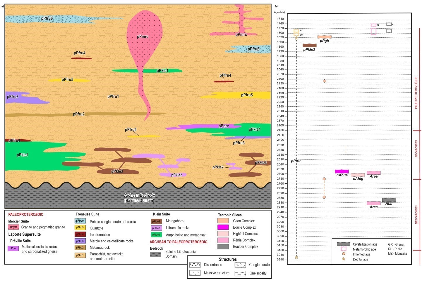
This section provides a summary description of stratigraphic units of the Rachel-Laporte Domain presented according to lithology type, spatial distribution and relative chronology. A more detailed description is available in the Stratigraphic Lexicon via the hyperlinks below. The stratigraphic diagram opposite illustrates the relationships between the different units. It is accompanied by a time scale listing the age of the units. References associated with dating can be found in the legend of the Rachel-Laporte Lithotectonic Domain map and in unit records of the stratigraphic lexicon.
Tectonic Slices
The Rachel-Laporte Domain comprises six structural complexes consisting of Archean or Paleoproterozoic rocks confined to tectonic slices that overthrusted rocks of the Laporte Supersuite during the New Quebec Orogenesis. These complexes include, from north to south, the following units: 1) tonalitic gneiss of the Boulder Complex (Ablr; 2868 Ma; Machado et al., 1989); 2) granitic gneiss of the Rénia Complex (Area; 2692 Ma; Davis et al., 2015); 3) porphyraceous monzogranite and quartz monzonite of the Highfall Complex (nAhig; 2705 Ma; Davis et al., 2015); 4) porphyraceous monzonite and monzodiorite of the Boullé Complex (nAbue; 2690 Ma; Rayner et al., 2017); 5) monzonite, quartz monzonite and monzodiorite of the Horseshoe Complex (ApPhrs); and 6) diatexites and migmatized paragneiss of the Giton Complex (1829 Ma; Rayner et al., 2019). With the exception of the Giton Complex diatexites and paragneiss, units observed in these complexes have a characteristic positive magnetic signature, which has not been recognized elsewhere in the Rachel-Laporte Domain. The crystallization of Giton Complex diatexites is also distinguished by its Paleoproterozoic age. It is still interpreted as a tectonic slice that overthrusted lower-grade metamorphic rocks.
The ages obtained and the lithologies observed within these tectonic slices are similar to those of different units of the Baleine Lithotectonic Domain (Ungava Complex, Saffray Suite, Lhande Suite and Winnie Suite), which would thus represent the basement on which Rachel-Laporte metasediments were deposited, as shown in this figure.
Paleoproterozoic Supracrustal Rocks and Associated Rocks
The Laporte Supersuite, which is the main unit of the Rachel-Laporte Domain, is dominated by Paleoproterozoic metasedimentary rocks of the Freneuse Suite (pPfru; 1834-1804 Ma; Henrique-Pinto et al., 2017; Godet et al., 2020). The latter comprises extensive sequences of biotite-muscovite paraschist, meta-arenite and meta-arkose, as well as lesser amounts of calcosilicate rocks, marble, quartzite, metamudrock, iron formation and metaconglomerate. Locally, the Freneuse Suite also contains a small amount of intermediate tuff-like laminated rocks as well as layers containing lenticular fragments, which may represent lapilli metatuff or lithic metawacke.
The Klein Suite (pPkle; 1883.5 Ma; Houlé et al., 2016) groups the majority of metamorphosed mafic and ultramafic rocks of effusive or intrusive origin in the domain. This unit occurs as decimetric to kilometric strips alternating with metasedimentary rocks of the Freneuse Suite. Mafic and ultramafic intrusions are mostly conformable with amphibolite and metasedimentary rock layers, but sharp crosscutting has been observed locally. The distribution of amphibolite strips and intrusions of the Klein Suite is not uniform throughout the Rachel-Laporte Domain. In some areas, metasedimentary rocks of the Freneuse Suite form large homogeneous sequences containing only rare strips of mafic rocks, whereas a more regular lithological alternation is observed in other places.
Although similar maximum ages of deposition have been obtained within samples of the Freneuse Suite in both the northern and central parts of the Rachel-Laporte Domain (~1834 Ma; Henrique-Pinto et al., 2017; Godet et al., 2020), the ~1883.5 Ma age obtained in gabbro of the Klein Suite indicates that the Freneuse Suite also includes sedimentary rocks deposited prior to 1834 Ma to allow the intrusion of mafic sills.
In the central part of the Rachel-Laporte Domain, the Préville Suite (pPprv) comprises mafic calcosilicate rocks and carbonate gneiss. Although the characteristic composition and geochemistry of rocks in this suite justify their belonging to a separate unit, it is possible that it represents a major metamorphosed alteration zone affecting units of the Klein and Freneuse suites (Charette et al., 2016). However, this unit is within the structural extension of the Lemoyne Complex carbonatite, located ~60 km to the NW, and could thus correspond to carbonatized metavolcaniclastite units.
Also in the central part of the domain, the Laporte Supersuite includes some sequences of meta-arkose, conglomeratic meta-arenite, meta-conglomerate and muscovite-hematite-specularite schist assigned to the Secondon Suite. This suite has not been dated, however, its location near the Boullé and Horseshoe complexes’ tectonic slices suggests that metasedimentary rocks may result from the erosion of these rocks. Boullé Complex rocks are Archean, Horseshoe Complex rocks are undated but may be Paleoproterozoic (equivalent to the Lhande Suite in the Baleine Domain).
Late Tectonic Intrusive Rocks
The Rachel-Laporte Domain differs from the other lithotectonic domains of SECP in that it has a low proportion of felsic intrusive rocks. Restricted to the southern end of the domain, the Hibou Stock groups a series of metric to decametric seams that cut metasedimentary rocks of the Freneuse Suite. These intrusions are variably foliated and considered to be synchronous with deformation by Girard (1995).
The Mercier Suite is concentrated in the northern part of the Rachel-Laporte Domain. It comprises a large (25 km by 5 km) pink granite intrusion that cuts Archean rocks of the Rénia and Highfall complexes, near the Lac Turcotte Fault. This suite also includes numerous felsic dykes and decimetric to decametric sills of pegmatitic granitoids. These intrusions are generally massive.
Mesoproterozoic Dykes
The entire SECP is cut by various swarms of mafic dykes exhibiting ophitic or subphitic texture. These dykes are grouped according to their orientation. They cut all units belonging to the SECP and extend beyond the limits of the lithotectonic domains. Two dyke swarms have been observed in the Rachel-Laporte Domain.
The Slippery Dykes (mPsip) group E-W to ENE-WSW oriented olivine gabbro and olivine gabbronorite dykes of the SECP. Two dykes a few kilometres long and hectometre wide were observed in the western central part of the Rachel-Laporte Domain.
The Falcoz Swarm (mPfal) groups NNW-SSE oriented olivine gabbro dykes of the SECP. A single dyke, approximately 2 km long and 180 m wide, has been assigned to this unit in the northern part of the SECP where it crosses the boundary between the Rachel-Laporte and Baleine domains.
Metamorphism
Like the Labrador Trough, to the west, and the Baleine Lithotectonic Domain, to the east, the Rachel-Laporte Lithotectonic Domain was metamorphosed during the Paleoproterozoic New Quebec Orogenesis. At the orogen scale, the metamorphic footprint is characterized by an increase in metamorphic intensity eastward (Dimroth and Dressler, 1978; Poirier, 1989; Perreault and Hynes, 1990; Clark and Wares, 2004; Godet et al., 2016). The Lac Hérodier Fault marks the transition from greenschist facies in the Labrador Trough to amphibolite facies in the Rachel-Laporte Domain. Further east, the Lac Turcotte Fault marks the upper amphibolite facies and partial melting in rocks of the Baleine Domain (Charette et al., 2016; Godet et al., 2018; Godet et al., 2020).
Fieldwork and microscopic petrographic observations have allowed identifying metamorphic assemblages of the Rachel-Laporte Domain, which show little variation from north to south (Simard et al., 2013; Lafrance et al., 2014; Charette et al., 2016). Metawacke and meta-arenite of the Freneuse Suite (pPfru1b), mostly composed of quartz-plagioclase-biotite-muscovite ± garnet ± K-feldspar ± apatite, are characterized by lepidoblastic and granoblastic textures. Assemblages are more diversified within paraschist (pPfru1a): quartz-plagioclase-biotite-muscovite-garnet ± staurolite ± cordierite ± sillimanite ± kyanite. Mafic rocks of the Klein Suite are composed of plagioclase-quartz-hornblende ± actinolite ± tremolite ± biotite ± garnet. Evidence of partial melting has been observed in metasedimentary rocks of the Freneuse Suite (Simard et al., 2013; Charette et al., 2016, Godet et al., 2016, Vanier, 2016). This phenomenon remains local and involves very small proportions of the affected rocks. All of this information indicates amphibolite facies regional metamorphism and local reach of the upper amphibolite facies, where the onset of partial melting is observed. This regional metamorphism associated with the New Quebec Orogen is part of a west-to-east Barrovian-type metamorphic field gradient.
Rocks of the Freneuse and Klein suites also contain minor amounts of retrograde chlorite and epidote in proximity to biotite, garnet or hornblende. Infill calcite is also common in metabasite, especially in the Jeannin Lake area (Charette et al., 2016).
Petrochronological and phase equilibrium modelling work on paraschist samples of the Freneuse Suite (pPfru1a) in the central segment of the Rachel-Laporte Domain has allowed interpretation of clockwise P-T-t paths (in P-T space) reflecting crustal thickening along an apparent Barrovian gradient (Godet et al., 2020). Burial of these samples is estimated to be around 1804 ±7.5 Ma (Lu-Hf age on garnet) and 1796 ±4 Ma (U-Pb on monazite). Peak metamorphic conditions are estimated at 620-650°C and 5.5-7 kbar. Finally, cooling, probably synchronous across the domain, is dated between 1783 and 1769 Ma (U-Pb on titanite, Machado et al., 1989).
Lithogeochemistry
The lithogeochemistry of units of the Rachel-Laporte Domain is presented separately in tabular form.
Structural Geology
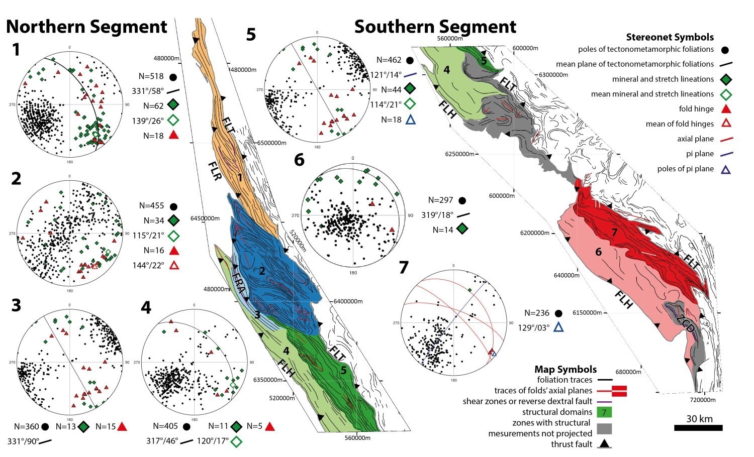
The Rachel-Laporte Lithotectonic Domain is divided into seven structural domains defined according to structural styles. Some areas requiring more detailed analysis have been excluded, so structural measurements for these areas are not projected. In the entire Rachel-Laporte Lithotectonic Domain, stratification and tectonometamorphic foliation measurements are globally equivalent and are therefore projected together on stereograms. The same is true for stretch and mineral lineations.
Structural Domain 1 is occupied by alternating metasedimentary rocks (Freneuse Suite) and metavolcanites (Klein Suite). Foliation traces describe sigmoidal shapes indicating dextral movement, which is consistent with the Pointe Reef and Lac Turcotte faults (Poirier, 1989; Goulet, 1995) that respectively mark the western and eastern boundaries of the Rachel-Laporte Domain in this area. The dominant fabric of Domain 1 is a regular penetrative foliation dipping relatively steeply towards the NE (68°). In general, stretch lineations dip slightly towards the SE. Fold hinges have a similar distribution, but are more dispersed along the great circle marking the mean foliation.
In its southern part, the Pointe Reef Fault no longer marks the boundary of the Rachel-Laporte Domain, but rather the boundary between Structural Domains 1 and 2. The latter is characterized by the presence of Paleoproterozoic tectonic slices consisting of Archean bedrock and emplaced over Paleoproterozoic supracrustal rocks. Thrusting of Archean units onto Paleoproterozoic units occurred via reverse faults acting as major basal detachments (Moorhead and Hynes, 1990). Domain 2 is also characterized by the presence of type 2 crescent fold interference patterns, according to the classification of Ramsay and Huber (1987). The interference pattern is interpreted to indicate the early formation of west-verging, N-S-axis dipping folds that were subsequently folded again by rather upright, shallow-dipping folds having NNW-SSE mean axis (144°/22°), which are the dominant structural feature of the area. Thus, tectonic slices form alternating elliptical domes and upright or SW-overturned synforms (Moorhead and Hynes, 1990). Measured lineations and fold axes (NNW-SSE) are parallel and would have developed concomitantly. Foliation poles are dispersed along a NE-SW great circle reflecting the last folding phase, but further analysis is required to fully account for polyphase folding observed in this domain. In map form, folds’ axial plane traces and foliation traces of this domain tend to have sigmoidal shapes indicating dextral movement, similar to what was observed in Domain 1.
To the SW of these tectonic slices, the dominant fabric is a NNW-SSE oriented subvertical penetrative foliation and a lineation slightly dipping to the SE on average. This domain includes the Lac Rachel reverse fault having a dextral component (Goulet, 1987).
Like their constituent metasedimentary rocks, domains 4 and 5 display a homogeneous and monotonous structural style defined by regular fabrics over several tens of kilometres. The foliation of Structural Domain 4 forms a homoclinal sequence having a mean plane of 316°/46° and in places bearing a stretch lineation slightly dipping towards the SE. Nevertheless, some lineations are close to the slope line or dip slightly towards the NW. Directly to the east, structural Domain 5 is distinguished by the presence of folded foliation traces. In addition, the projection of tectonometamorphic foliation poles forms an asymmetric distribution spread along a great circle, the pole of which lies close to the mean of measured fold hinges (116°/23°). Stretch lineations also have a similar orientation and inclination of 113°/20°. Structural Domain 5 is interpreted as an asymmetric fold sequence with long flanks dipping towards the NE.
Domains 6 and 7 are structurally and lithologically continuous with domains 4 and 5. In Domain 6, foliation is continuous, slightly undulating and very shallowly dipping towards the NE. The mean plane is 310°/16°. Lineations are sparser. Several of them are NE oriented and some are NW oriented. The regional foliation is possibly affected by isoclinal folds (Girard 1995; Vanier et al., 2017). From foliation traces, folds are most evident in Domain 7. However, they remain difficult to characterize given the lack of structural measurements and large areas without outcrops. Foliation poles are ambiguously distributed along a great circle with the 129°/03° pole close to measured fold hinges. Nevertheless, foliation measurements are concentrated in the SW quadrant. This dispersion is interpreted as reflecting asymmetric folds with long flanks dipping towards the NE. According to three axial plane measurements, these folds also dip moderately towards the SW. In the NW and SE parts of Domain 7, the foliation trace is affected by crescent fold interference. Polyphase folding affects the Lac Turcotte thrust fault which marks the boundary with the Baleine Lithotectonic Domain.
The structural geology of the southern end of the Rachel-Laporte Domain has been studied by Girard (1995), where he identified mesoscopic recumbent or SW-overturned folds. Crenulation schistosities are also common in this area, as are crescent fold interference patterns (type 2). Girard (1995) also describes the Lac Deborah Shear Zone. The fabrics within it are distinguished by a higher intensity and a subvertical dip. Lineations are more pronounced and dip slightly towards the SE. Overall, kinematic indicators indicate dextral displacement.
The regional NNW-SSE structural grain was acquired during the New Quebec Orogenesis. Supracrustal rocks of the Rachel-Laporte Lithotectonic Domain and Labrador Trough then developed a fold and thrust belt structural style (Clark and Wares, 2004). In the Rachel-Laporte Domain, deformation is expressed as homoclinal sequence zones (domains 1, 3, 4 and 6), where the regional foliation dips towards the ENE. These domains are located on the western side of the Rachel-Laporte Domain. Within these homoclinal sequences, the most deformed areas, namely domains 1 and 3, display a foliation closer to the vertical. The eastern part of the Rachel-Laporte Domain (domains 5 and 7) has been affected by asymmetric folds dipping <20° towards the SSE and with long flanks dipping towards the ENE. Tectonic slices composed of Archean rocks and emplaced in the Palaeoproterozoic are found sparsely, the most important being in the northern area (Domain 2). Part of Domain 2 is also affected by polyphase folding that produced a crescent-shaped pattern visible on foliation traces. All of the fabrics described above are consistent with a compressive regime of approximately NE-SW to NW-SE axis. The oldest structures are certain reverse faults (Lac Hérodier and Lac Turcotte faults) and westward overturned folds observed in structural domains 2 and 7. Subsequently, and still in compression, upright folds whose axis dips <20° towards the SSE affected almost the entire Rachel-Laporte Domain. This second folding phase seems to be synchronous with the development of the stretch lineation, which also generally dips <20° towards the SSE. These structural features are similar to those of the Labrador Trough (Clark and Wares, 2004), thus supporting a structural continuity between these two lithotectonic domains.
The collision between the Superior Craton and the hinterland to the east (Baleine Domain) is often described as having a strong dextral oblique component that is reflected in later dextral strike-slip structures or partitioning of deformation between reverse faults and dextral strike-slip shears (Moorhead and Hynes 1990; Goulet 1995; Girard, 1995; Hoffman, 1990; Konstantinovskaya, 2019). The Lac Rachel Fault and the Lac Deborah Shear Zone accommodate these dextral movements in the Rachel-Laporte Domain. The evolution of the obliquity of the New Quebec Orogenesis may have resulted in the formation of dextral strike-slip structures. Changes in transport direction or principal stresses reflecting a change in collision obliquity have been proposed previously (Moorhead and Hynes, 1990; Tremblay-Hébert and Lee, 2018; Konstantinovskaya, 2019).
Regional Tectonic
The Rachel-Laporte Domain occupies the central position of the New Quebec Orogen, and the stratigraphic units within it are divided into two main groups: tectonic slices consisting mainly of Archean bedrock and supracrustal rocks of the Laporte Supersuite, including the Freneuse Suite, which was deposited between 1834 Ma (Henrique-Pinto et al., 2017) and 1805 Ma (Godet et al., 2020). Each of these suites captures an aspect of the tectonic evolution of the Rachel-Laporte Domain.
First, the comparative study of detrital zircon populations of the Freneuse Suite and the Kaniapiscau Supergroup by Henrique-Pinto et al. (2017) highlights a major contrast in sedimentation environment between the Labrador Trough and the Rachel-Laporte Domain. In the former, the lag between the minimum age of deposition and crystallization of detrital zircons is in the order of a few hundred million years, consistent with a passive margin or rift geodynamic setting (Cawood et al., 2012). In contrast, the time lag in the Rachel-Laporte Domain is of the order of only 40 million years, suggesting a convergent tectonic setting. The sedimentary environment is interpreted as having evolved from a continental forearc basin, corresponding to the more mature sedimentary units, to a collisional foreland basin during the New Quebec Orogenesis (Henrique-Pinto et al., 2017, 2019). Convergent tectonics active during this orogenesis then led to the development of major thrust faults through which tectonic slices composed mainly of Archean units were emplaced above Paleoproterozoic metasedimentary rocks. The presence of these tectonic slices is evidence of thick-bedded tectonics that may also have caused the local intercalation of rocks originally belonging to the Labrador Trough, but which were tectonically imbedded in the Rachel-Laporte Domain. As many lithologies are similar on both sides, the most effective tool to test this hypothesis would be the more systematic use of geochronology, especially targeted within mafic rocks of the Klein Suite, for which there are insufficient data to place them stratigraphically with confidence.
Burial of the Rachel-Laporte Domain beneath the Baleine Domain during the New Quebec Orogenesis caused regional amphibolite facies metamorphism. The Baleine Domain is interpreted to have been thrusted westward through the Lac Turcotte Fault. Thus, burial of the Rachel-Laporte Domain is synchronous with exhumation of the Baleine Domain and the Lac Turcotte Fault represents a tectonometamorphic discontinuity (Godet et al., 2020).
Geodynamic settings, such as a continental forearc basin and a foreland basin in combination with the mismatch between metamorphism in the inner zone of the orogen (Baleine Domain) and recycling in the foreland basin (Rachel-Laporte Domain) support an accretionary orogenic style similar to that recognized in the Phanerozoic (Godet et al., 2020). Thus, recent work supports the original interpretations that the New Quebec Orogenesis represents an example of Phanerozoic style tectonics as early as the Paleoproterozoic (Hoffman, 1988; Wardle et al., 2002).
Economic Geology
The Rachel-Laporte Lithotectonic Domain is prospective for several types of mineralization:
- Volcanogenic massive sulphide mineralization associated with the Laporte Supersuite;
- Polymetallic mineralization in graphitic claystones of the Freneuse Suite;
- Cr-Ni mineralization in ultramafic intrusions of the Klein Suite;
- Rare metal mineralization associated with the Préville Suite.
The table of mineralized zones below presents analytical results for the 9 known mineralized zones in the area.
| Name | Contents |
|---|---|
| Copper-Bearing Seam | |
| Lac Sinaujarjuaq | 8020 ppm Cu (G) |
| Chromite Mineralization in Mafic and Ultramafic Rocks | |
| Buteux | 46 238.151 ppm Cr (G); 1632.9 ppm Ni (G) |
| Exhalative Sulphide Mineralization | |
| Ballantyne Nord | 308 700 ppm Fe (G); 3471.3 ppm Cu (G) |
| Ballantyne Sud | 362 000 ppm Fe (G) |
| Passe Algérine | 352 000 ppm Fe (G); 365 ppm Cu (G) |
| Rivière Savalette | 10 000 ppm Cu (G); 1000 ppm Ni (G); 1300 ppm Zn (G) |
| Polymetallic Mineralization in Black Shales | |
| Rivière Freydière | 1730 ppm V (G); 792 ppm Cu (G); 28.9% Ctot (G) |
| Marcel | 7.7% Cg (G); 379 ppm Zn (G); 767 ppm V (G); 60 ppm As (G); 24 ppb Au (G); 31 ppm U (G) |
| Mineralization of Undetermined Type | |
| Lac Olmstead | 7 ppm Ag (G); 824 ppm Cu (G) |
(G) Selected sample
The table of lithogeochemical analyses of metals of economic interest gives the location, description and analytical results for 212 selected samples in order to assess the economic potential of the area.
Volcanogenic Massive Sulphide Mineralization Associated with the Laporte Supersuite
The regular alternation of metasedimentary rocks of the Freneuse Suite with amphibolite of the Klein Suite makes the Laporte Supersuite a good environment for volcanogenic massive sulphides (VMS). Disseminated sulphides and rusty layers are commonly observed within these units. Several lenses of massive to semi-massive sulphides associated with hydrothermal alteration (silica, chlorite and carbonate) have also been observed within amphibolite and metasedimentary rocks. Although relatively few showing contents were obtained during the Ministère‘s various mapping campaigns, many rust zones could not be analyzed and further work is required to fully assess the economic potential of the Rachel-Laporte Domain for this type of mineralization.
Mineralization observed in the Rachel-Laporte Domain shares many similarities with Besshi type deposits: 1) rocks that host massive sulphides are dominated by metawacke and metapelite sedimentary rocks; 2) felsic igneous rocks are sparse or absent; 3) the proportion of mafic rocks is generally minor compared to metasedimentary rocks; 4) massive sulphides are dominated by pyrrhotite or pyrite with variable amounts of chalcopyrite and smaller amounts of sphalerite (Peter and Scott, 1999). The presence of graphitic or carbonatized material is also common in Besshi type deposits, also known as pelitic-mafic volcanogenic massive sulphides (Franklin et al., 2005). The settings of these deposits are varied and include forearc basins (Peter and Scott, 1999). The first cycle of the Laporte Supersuite is interpreted by Henrique-Pinto et al. (2017, 2019) as being represented by the deposition of conglomerate and arkose in a continental forearc basin setting.
Two large areas appear particularly prospective: the Olmstead prospective zone (125 km by 2 to 6 km) in the northern part of the Rachel-Laporte, and the Wheeler prospective zone (35 km by 2 to 7 km) further south. The magnetic pattern of these areas includes numerous very strong lineaments over several kilometres and associated with the presence of hectometric to kilometric amphibolite layers. These prospective zones are respectively bounded to the east by the Lac Olmstead et du Lac Turcotte faults. Lake sediment spot anomalies in Zn, Y, La and U are also common in these areas (Lamothe, 2010).
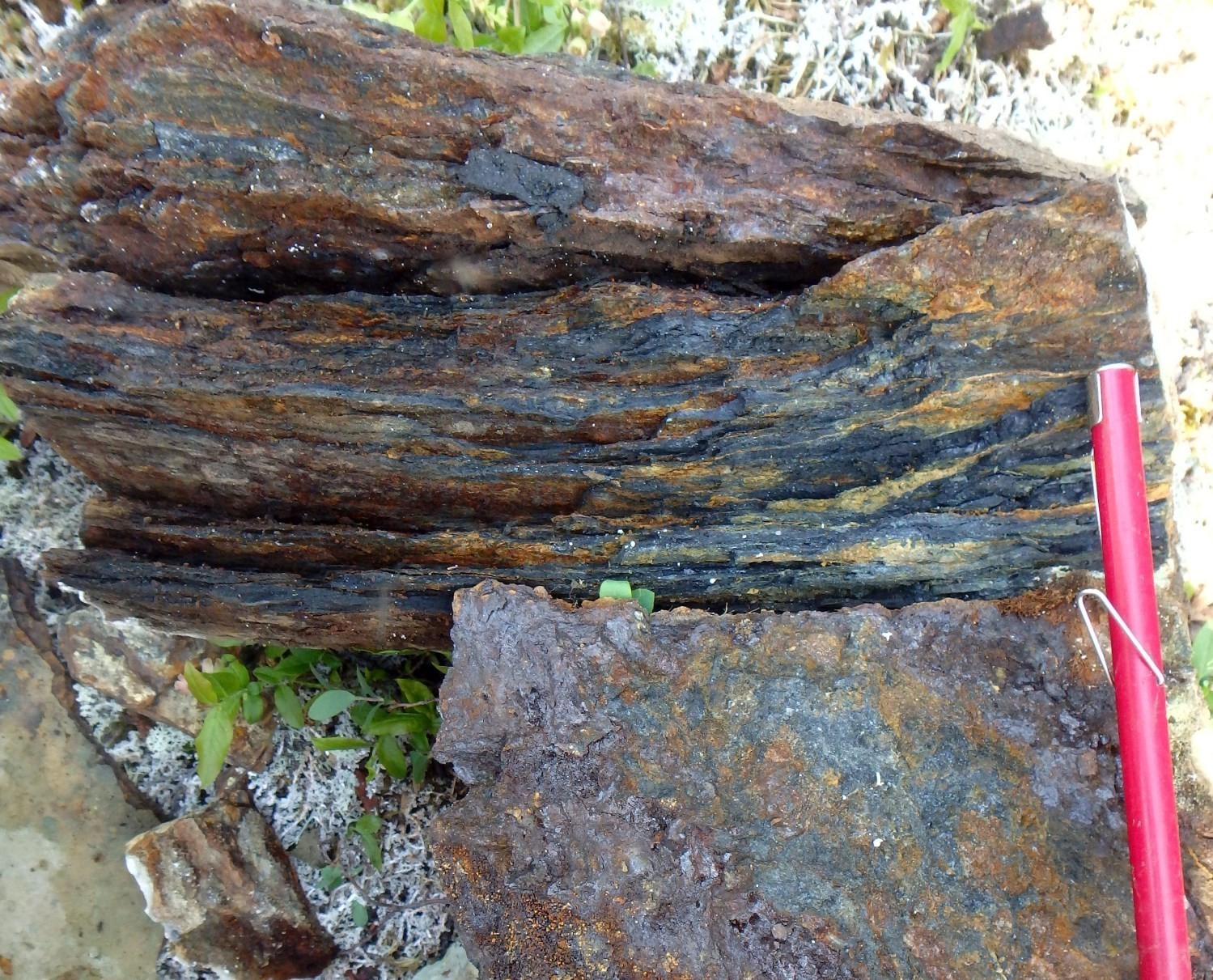
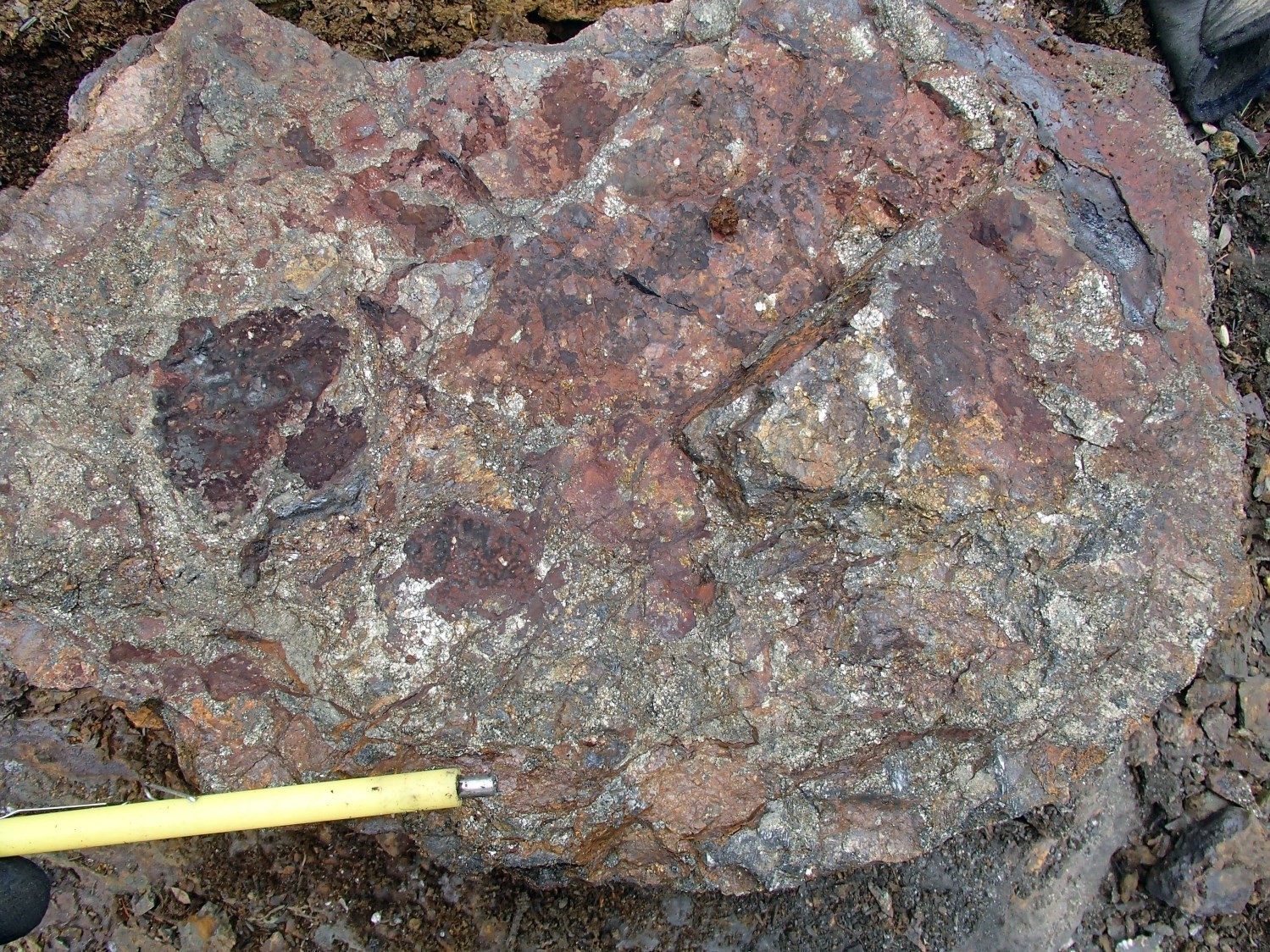
 The Olmstead prospective zone includes three Fe or Ag mineralized zones (showings) (Ballantyne Nord, Ballantyne Sud and Lac Olmstead) and numerous anomalous and significant Cu (<4020 ppm Cu) and Zn (<2100 ppm Zn) contents. Metric to hectometric rusty layers of banded iron formation, black graphite claystone and semi-massive to massive sulphides have been described on nearly thirty outcrops. This type of association between iron formations, claystones and massive sulphides is reminiscent of Type 3a and 2 deposits described by Clark and Wares (2004) in the Labrador Trough. Massive sulphides are brecciated and consist of a fine matrix of pyrrhotite (<70%), pyrite (5 to 10%) and graphite (10%) with felsic fragments of the host rocks. Centimetric to metric quartz ± carbonate veins and millimetric calcite-hematite veinlets cut the host rocks and massive sulphides in several places. These veins and veinlets could represent a deformed stockwork zone, which is no longer in the form of a chimney, typical of VMS. Iron formation layers contain chert, magnetite, amphibole, sulphides ± hematite ± garnet. Sulphides are also finely disseminated in graphitic argillite layers and in the surrounding rocks (amphibolite and metasedimentary rocks). These include pyrite (<10%), pyrrhotite (<10%), chalcopyrite (<5%), chalcocite (<%), bornite (<1%) and arsenopyrite (<10%).
 The Wheeler zone comprises five outcrops having metric to hectometric rusty layers containing disseminated to semi-massive sulphides. The context is similar to that of the Olmstead zone, however, quartz veinlets containing up to 15% pyrrhotite are also present locally. Several anomalous Zn (<3830 ppm) and Cu (<1080 ppm) contents were obtained within selected samples.
The Consigny prospective zone (4 km by 500 m) also represents a similar context, where numerous rusty layers of iron formation, graphite slate and semi-massive sulphides have been observed at the contact between amphibolite and paraschist. Sulphides (5 to 20%) are mostly disseminated with metric layers of semi-massive sulphides (45%). The latter are brecciated and consist mainly of pyrrhotite with traces of sphalerite and chalcopyrite. The host rocks locally contain dismembered quartz veinlets which contain disseminated or clustered sulphides in the walls. Lake sediment anomalies in Zn, Ni, La and Y are spatially associated.
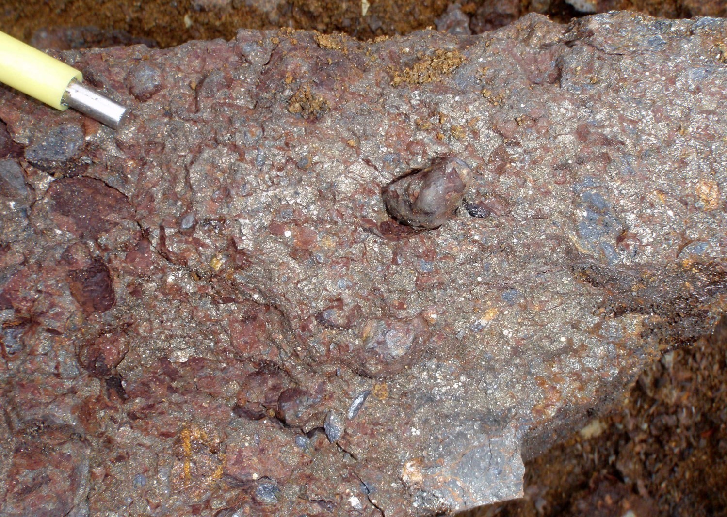
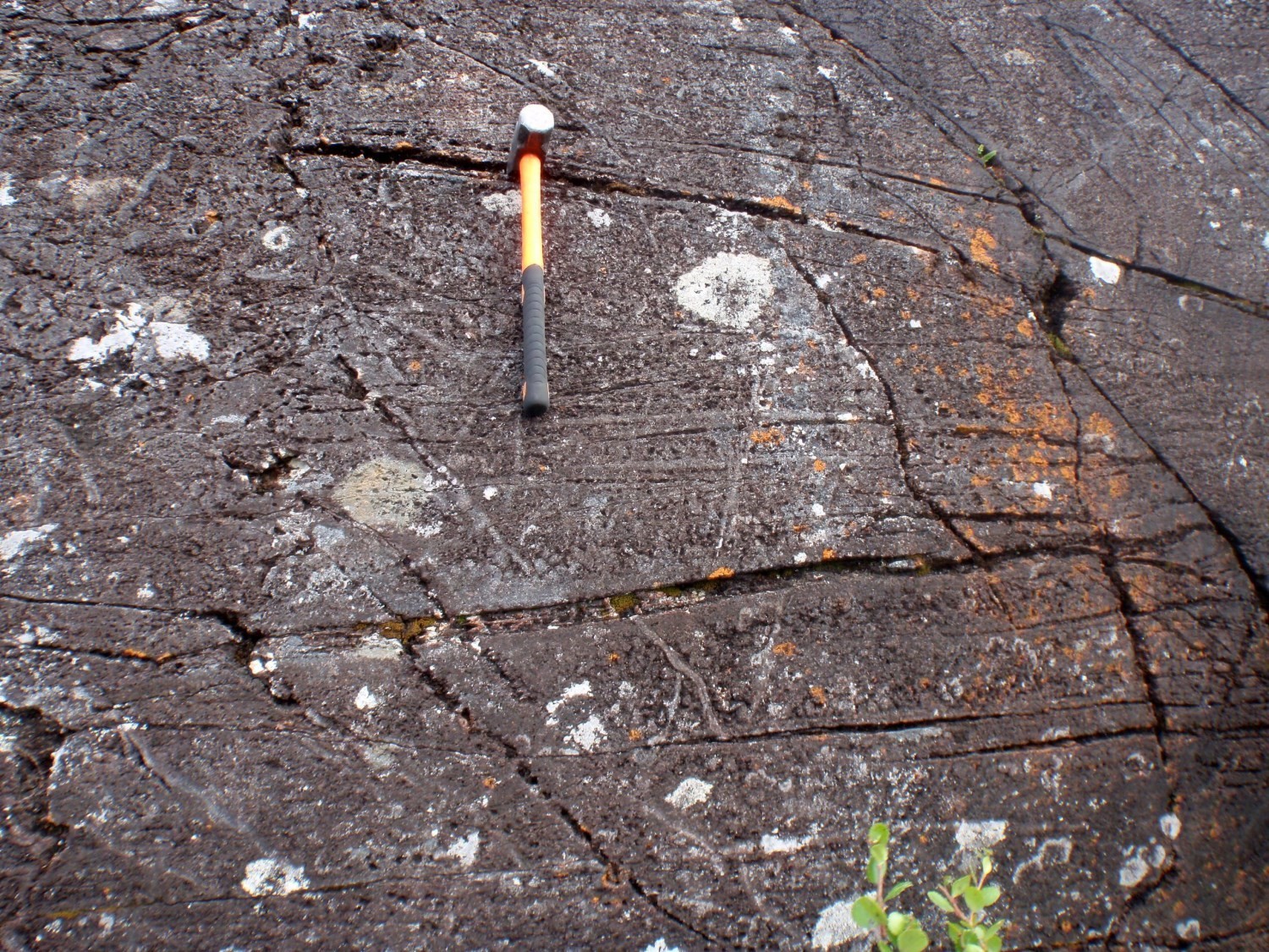
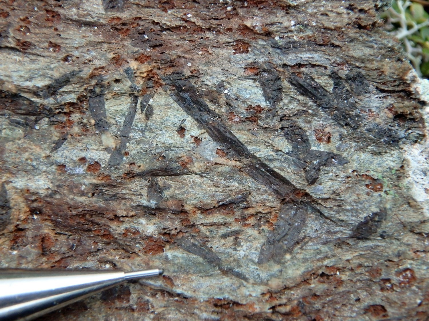
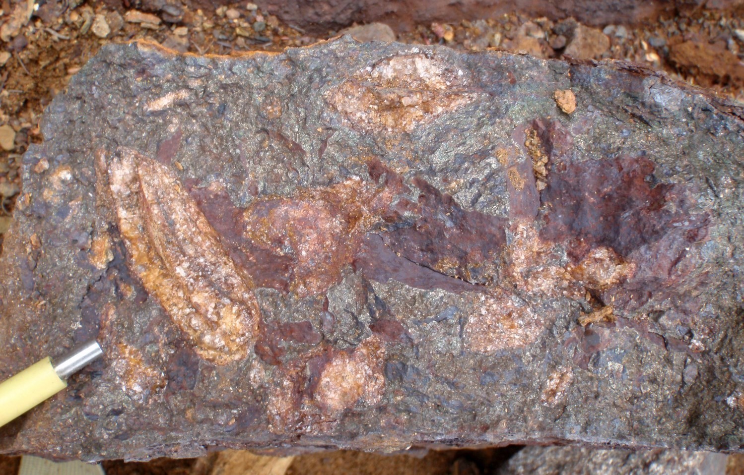 Several other similar, but smaller, rust zones have been observed at various locations in the Laporte Supersuite. Among others, in the area of outcrops 15-LP-2098 and 15-LP-2100 (located 650 m apart along strike), a dismembered massive sulphide horizon is associated with a 10 km long, strongly magnetic lineament. The rock is composed of fine pyrrhotite associated with 2 to 15% subhedral pyrite crystals (1-15 mm). It also contains 15 to 35% subrounded to subangular fragments of chert, quartz and oxidized quartzofeldspathic rocks. This breccia, consisting of competent clasts within a less competent matrix, is reminiscent of a Durchbewegung texture. This type of texture, commonly interpreted as forming in a tectonic context (Marshall and Gilligan, 1989), has been observed, among others. In the Deborah Lake area, a selected sample (1988011512) from a rusty paraschist (10 m by 150 m) yielded anomalous Cu (3270 ppm Cu) and Ni (2320 ppm Ni) contents. Sulphides are disseminated and consist of pyrite (<15%) with traces of chalcopyrite. Schist is located along a shear zone and is cut by decimetric quartz veins. At the Rivière Savalette mineralized zone, a 3 m brecciated layer of semi-massive sulphides (pyrrhotite and chalcopyrite) with graphitic slate elements that sporadically outcrops over a length of nearly 600 m yielded 1% Cu, 0.1% Ni and 0.13% Zn.
Polymetallic Mineralization in Graphitic Claystones of the Freneuse Suite
Black shales, due to their high concentration of organic matter constituting a very reducing environment, represent a good environment for the concentration of various metals. Elements trapped in this way include, among others, base metals (Cu, Pb, Zn, Ni, Co), precious metals (Au, Ag, PGE), rare elements (Li, Be, Ta, Mo, Tl, V, Sn, U and rare earths), graphite and phosphates (Gouin, 2008). The Rachel-Laporte Domain comprises metamudstone sequences, the thickest of which are located at the contact with Labrador Trough units. The Le Moyne prospective zone, dominated by this type of rock, is 1 to 3 km wide and about 100 km long along the contact between the Labrador Trough and the Rachel-Laporte Domain, represented in this area by the Lac Hérodier Fault. This unit has been little visited during regional mapping and deserves special attention since several lake sediment anomalies are associated with it (Lamothe, 2010).
 In its southern part, the Le Moyne prospective zone also corresponds to a linear spectrometric target (D’Amours and Simard, 2012) and includes the Marcel graphite mineralized zone. This site is characterized by a very fine-grained (<1%) rusty garnet rock (Charette et al., 2016). Mineralization consists of graphite locally forming fine flakes (<0.5 mm) aligned along schistosity. Sulphide traces are also observed. Samples 2015062753 and 2015062754 yielded contents >7% graphitic carbon in addition to anomalous vanadium (<767 ppm) and significant Cu, Mo, Y, Zn, Ag and U contents.
In the southern part of the Rachel-Laporte Domain, the Rivière Freydière mineralized zone, breccia containing graphite fragments hosted in graphitic phyllites, is also enriched in various metals, such as vanadium (<1730 ppm V), copper (<792 ppm Cu), zinc (<1090 ppm Zn), molybdenum (<135 ppm Mb) and gold (<112 ppb Au). The breccia zone is visible over 200 m in length and 10 m in thickness and then sporadically outcrops for a further 800 m (Girard, 1995). Fragments are centimetric to decimetric, angular and represent >80% of the rock. They consist of powdery graphite (up to 28.9% Cg) in a micro-grained quartz paste. Fine dissemination of pyrrhotite containing sphalerite and chalcopyrite inclusions are locally present. The breccia matrix is composed of hydrothermal quartz (80%) and sulphides (20%), mainly pyrite and pyrrhotite (Girard, 1995). Pyrite also occurs in a network of veinlets invading fragments or the surrounding rock.
Rare Metal Mineralization in the Préville Suite
 The enrichment in low mobile elements (Nb, Ta, P, Y, Zr and light REE) as well as in Ba and Sr of several samples collected within the Préville Suite led Charette et al. (2016) to question the origin of the rocks of this suite and to consider it as a prospective unit for rare metal mineralization. The Préville Suite, which consists of calcosilicate rocks and carbonatized gneiss, is located in the structural extension of the Le Moyne Complex (65 km to the NNW), which hosts nine niobium, tantalum, zirconium and rare earth mineralized zones, including the Ashram deposit. Préville Suite rocks may thus correspond to carbonatized metavolcaniclastite units related to rocks of the Le Moyne Complex, which includes carbonatite intrusions and mafic, ultramafic and carbonatitic volcaniclastites (Birkett and Clark, 1991).
 However, the Préville Suite may also represent a vast zone of metamorphic alteration hosted within mafic rocks of the Klein Suite and metasedimentary rocks of the Freneuse Suite. In this sense, fragmentary massive sulphide layers have also been observed locally within the Préville Suite on outcrops 15-MP-1085, 15-MO-7068 and15-JC-5067. The matrix of these breccias is composed of fine pyrrhotite with some millimetric pyrite (<2%) and the fragments (5 to 15%), millimetric to centimetric, consist of quartzofeldspathic rocks and quartz. Pyrrhotite and pyrite veinlets locally cut mafic rocks near massive sulphide layers. Several samples have anomalous copper contents (<700 ppm). However, more work is required to fully evaluate the potential of this unit.
Chromium Mineralization in Ultramafic Intrusions of the Klein Suite
 Peridotite of the Klein Suite contains 3 to 7% opaque minerals in disseminated form or in nodules. These opaque minerals consist of chromite, which forms 2-3 mm cubic crystals, and very fine magnetite and pyrrhotite. Contents locally reach 6.76% Cr2O3 at the Buteux mineralized zone, which corresponds to a magnetic lineament nearly 3 km long and 500 m wide. The chromite mineralized rock is peridotite containing relics of olivine cumulus in gradual contact with pyroxenite and then with gabbro.
Other areas of interest are represented by the Turgis and Boullé prospective zones. The former comprises two differentiated gabbro and peridotite intrusions associated with magnetic lineaments 3 km and 10 km long, respectively. The second consists of two peridotite intrusions containing olivine cumuli and corresponding magnetic lineaments a few kilometres long. Several anomalous Cr contents (<0.94% Cr2O3) were obtained in various samples taken from outcrops in these areas. A 0.76% Cr2O3 content was also obtained in a peridotite sample from outcrop 15-RP-2133, which corresponds to a magnetic lineament approximately 1 km long in the Rachel Lake area. Anomalous nickel contents (<1940 ppm Ni) in these samples are not significant and appear to be associated with silicates such as pyroxene, olivine and serpentine.
| Authors |
Isabelle Lafrance, P.Geo., M.Sc. isabelle.lafrance@mern.gouv.qc.ca Marc-Antoine Vanier, Jr. Eng., M.Sc. marc-antoine.vanier@mern.gouv.qc.ca |
| Geomatics | Julie Sauvageau |
| Critical review | Carl Bilodeau, P.Geo., M.Sc. |
| Editing | Simon Auclair, P.Geo., M.Sc. |
| Template and content compliance | François Leclerc, P. Geo., Ph.D. |
| English version | Céline Dupuis, P. Geo., Ph.D. |
| Organism | General direction of Géologie Québec, Ministère de l’Énergie et des Ressources naturelles, Government of Québec |
Acknowledgements:
This Geological Bulletin was made possible through the cooperation of many people who actively took part in the various stages of the project. We would like to thank the entire crew of geologists, students and support staff who participated in the Ministère’s mapping work during the summers of 2009, 2011, 2012, 2015 and 2016. The authors would also like to thank Antoine Godet and James Moorhead for relevant discussions and comments that helped to deepen the understanding of the geology of the area and to clarify the presentation of these ideas.
References
Publications Available Through Sigéom Examine
BOURQUE, Y. 1991. Géologie de la région du lac Mina (Territoire-du-Nouveau-Québec). MRN. ET 88-08, 49 pages and 4 plans.
CHARETTE, B., LAFRANCE, I., VANIER, M.-A., 2016. Géologie de la région du lac Jeannin. MERN; BG 2015-01, 1 plan.
CLARK, T., 1978. Région du lac Hérodier. MRN, Québec; DPV-568, 43 pages, 2 plans.
CLARK, T., 1980. Région de la rivière Koksoak (Nouveau Québec). MER, Québec; DPV-781, 20 pages, 1 plan.
CLARK, T., 1987. Stratigraphie, pétrographie et pétrochimie de la Formation de Fer de Baby, région du lac Hérodier (Fosse du Labrador). MER, Québec; ET 87-13, 42 pages.
CLARK, T., WARES, R., 2004. Synthèse lithotectonique et métallogénique de l’Orogène du Nouveau-Québec (Fosse du Labrador); MM 2004-01, 182 pages, 1 plan.
D’AMOURS, I., INTISSAR, R., 2012a. Levé magnétique et spectrométrique aéroporté dans le secteur du lac Le Moyne, Province de Churchill. MRNF; DP 2011-06, 8 pages, 200 plans.
D’AMOURS, I., INTISSAR, R., 2012b. Levé magnétique et spectrométrique aéroporté de la rivière Koksoak, Province de Churchill. MRNF; DP 2011-07, 8 pages, 180 plans.
D’AMOURS, I., INTISSAR, R., 2013. Levé magnétique et spectrométrique aéroporté dans le secteur du lac Romanet, Province de Churchill. MRN; DP 2013-02, 10 pages, 280 plans.
D’AMOURS, I., SIMARD, M., 2012. Cibles d’exploration déterminées à partir des données de spectrométrie dans les secteurs du lac Le Moyne et de la rivière Koksoak, Province de Churchill. MRNF; PRO 2012-01, 8 pages.
DANIS, D. 1988. Géologie de la région du lac Recouet (Territoire-du-Nouveau-Québec). MRN. ET 86-11, 62 pages and 4 plans.
DAVIS, D.W., MOUKHSIL, A., LAFRANCE, I., HAMMOUCHE, H., GOUTIER, J., PILOTE, P., TALLA TAKAM, F., 2015. Datations U-Pb dans les provinces du Supérieur, de Churchill et de Grenville effectuées au JSGL en 2012-2013. MERN; RP 2014-07, 56 pages.
DIMROTH, E., 1978. Région de la fosse du Labrador entre les latitudes 54° 30′ et 56° 30′. MRN; RG 193, 417 pages, 16 plans.
DRESSLER, B., CIESIELSKI, A. 1979. Région de la Fosse du Labrador. MRN. RG 195, 136 pages and 14 plans.
DUMONT, R., DOSTALER, F., 2010. Séries des cartes géophysiques, parties des SNRC 24K et 24L, Levé magnétique aéroporté de la région de la Baie d’Ungava, Québec. MRNF, Québec; DP 2010-08, 6 pages, 2 plans, numerical data.
FOURNIER, D. 1985. Minéralisation de la partie orientale du géosynclinal du Labrador (Groupe de Laporte). MRN. ET 83-23, 57 pages and 4 plans.
FREEDMAN, R.O., PHILPOTTS, J.A., 1958. Report on Red Dog Iake area (Ungava). Ministère des Mines, Québec, DP 49, 13 pages, 1 plan.
GÉLINAS, L. 1958a. Rapport préliminaire sur la région du lac Gabriel (partie ouest), Nouveau-Québec. MRN. RP 373, 13 pages and 1 plan.
GÉLINAS, L. 1958b. Rapport préliminaire sur la région du lac Thévenet (moitié est), Nouveau-Québec. MRN. RP 363, 11 pages and 1 plan.
GIRARD, R. 1995. Géologie de la région du lac Deborah, Territoire-du Nouveau-Québec. MRN. MB 95-20, 186 pages and 3 plans.
GODET, A., GUILMETTE, C., LABROUSSE, L., VANIER, M-A., CHARETTE, B., 2017. Caractérisation du gradient métamorphique dans la croûte moyenne de l’Orogène du Nouveau-Québec et relations à la tectonique. Université Laval, Laboratoire de tectonique, MERN; MB 2017-16, 177 pages.
GODET, A., LABROUSSE, L., VANIER, M-A., CHARETTE, B., GUILMETTE, C., 2016. Étude pétrographique de la Zone de Rachel-Laporte et de la Zone noyau (SNRC 24B), Province de Churchill SE, Québec. Université Laval, Université Pierre et Marie Curie, MERN; MB 2016-09, 28 pages.
GODET, A., VANIER, M.-A., GUILMETTE, C., LABROUSSE, L., CHARETTE, B., LAFRANCE, I., 2018. Chemins PT et style d’exhumation du Complexe de Mistinibi, Province du Churchill Sud-Est, Canada. MERN, UNIVERSITE LAVAL, SORBONNE UNIVERSITE; MB 2018-31, 32 pages.
GOLD, D.P., 1962. Rapport préliminaire sur la région de la baie opes Advance, Nouveau-Québec. MRN; RP 442, 13 pages, 1 plan.
GOULET, N., 1986. Étude tectonique et stratigraphique de la partie nord de la Fosse du Labrador – région de la baie aux Feuilles et du lac Bérard. MER, Québec; MB 86-27, 22 pages, 6 plans.
GOULET, N., 1987. Étude tectonique de la partie nord de la fosse du Labrador, rapport intérimaire. MER, Québec; MB 87-21, 33 pages, 4 plans.
GOULET, N., 1995. Étude structurale, stratigraphique et géochronologique de la partie nord de la Fosse du Labrador. Ministère des Ressources naturelles, Québec; MB 95-36, 39 pages, 1 plan.
TREMBLAY HEBERT, S., LEE, C., 2018. Technical report, 2018 exploration program, Kan project. OSISKO BAIE-JAMES SENC, assessment work submitted to the Government of Québec. GM 71136, 1828 pages, 14 maps.
HAMMOUCHE, H., LEGOUIX, C., GOUTIER, J., DION, C., PETRELLA, L., 2011. Géologie de la région du lac Bonaventure. MRNF; RG 2011-03, 37 pages, 1 plan.
LAFRANCE, I., SIMARD, M., BANDYAYERA, D., 2014. Géologie de la région du lac Saffray (SNRC 24F, 24G). MRN; RG 2014-02, 51 pages, 1 plan.
LAMOTHE, D., 2010. Modélisation de cibles de l’environnement secondaire par des techniques de seuils naturels et de régression spatiale multiple. MRNF; EP 2010-01, 28 pages.
SAUVÉ, P. 1956. Rapport préliminaire sur la région du lac de Freneuse (moitié ouest), Nouveau-Québec. MRN. RP 332, 10 pages and 1 plan.
SAUVÉ, P. 1957a. Rapport préliminaire sur la région du lac de Freneuse (moitié est), Nouveau-Québec. MRN. RP 358, 10 pages and 1 plan.
SAUVÉ, P. 1959. Rapport préliminaire sur la région du le la baie aux Feuilles, Nouveau-Québec. MRN. RP 399, 15 pages and 1 plan.
SAUVÉ, P., BERGERON, R., 1965. Région des lacs Gerido et Thévenet, Nouveau-Québec. Ministère des Richesses naturelles, Québec; RG 104, 124 pages, 3 plans. RG 104
SIMARD, M., LAFRANCE, I., HAMMOUCHE, H., LEGOUIX, C., 2013. Géologie de la région de Kuujjuaq et de la baie d’Ungava (SNRC 24J, 24K). MRN. RG 2013-04, 62 pages, 1 plan.
VANIER, M-A., GUILMETTE, C., HARRIS, L., GODET, A., CLEVEN, N., CHARETTE, B., LAFRANCE, I., 2017. Analyse structurale et microstructures des zones de cisaillement de la Rivière George et du Lac Tudor. Université Laval, INRS, MERN; MB 2017-12, 50 pages.
Other Publications
BARDOUX, M., DIGONNET, S., DONOHUE, L., GIARD, B., ROBILLARD, M., DAVID, J., PARENT, M., GARIÉPY, C., 1998. Paleoproterozoic tectonics affecting Archean lower crust of southern Ungava Bay. In : Eastern Canadian Shield Onshore–Offshore Transect (ECSOOT), Report of the 1998 Transect Meeting. Compiled by RJ Wardle and J. Hall. The University of British Columbia, Lithoprobe Secretariat, Report, volume 68, pages 1-17.
BELL, R., LOW, A.P., 1900. Map of the coast of Hudson Strait and Ungava Bay, district Franklin and Ungava. Geological Survey of Canada. doi.org/10.4095/107521
BÉRARD, J., 1959. Géologie de la région du lac aux Feuilles, Nouveau-Québec. Thèse de doctorat, Université Laval, Québec, Québec, 368 pages.
BIRKETT, T.C., CLARK, T. 1991. Géologie et potentiel métallifère de la carbonatite protérozoïque du lac LeMoyne dans le nord du Québec. Commission géologique de Canada; Forum des travaux en cours, Programme et Résumés, page 20.
CAWOOD, P. A., HAWKESWORTH, C. J., DHUIME, B., 2012. Detrital zircon record and tectonic setting. Geology, volume. 40, no 10, pages 875-878. doi.org/10.1130/G32945.1
DE ROMER, H. S., 1956. The geology of the eastern border of the « Labrador Trough », east of Thevenet lake, New Quebec. M. Sc. Thesis, McGill University, Montréal, Québec, 93 pages. Source
DIMROTH, E., DRESSLER, B., 1978. Metamorphism of the Labrador trough. In: Metamorphism in the Canadian Shield (Fraser, J.A., Heywood, W.W., editors). Geological Survey of Canada, Paper 78-10, pages 215-236. doi.org/10.4095/104534
FAHRIG, W.F., 1965. Geology, Lac Herodier, Québec. Geological Survey of Canada; « A » Series Map 1146A, 1 sheet. doi.org/10.4095/107520
FERGUSON, J., 1958. A study of metamorphic strata near Fort Chimo, Northern Quebec. McGill university; M. Sc. thesis, 117 pages. Source
FRANKLIN, J.M., GIBSON, H.L., JONASSON, I.R., GALLEY, A.G., 2005. Volcanogenic massive sulfide deposits. In: Economic Geology One Hundredth Anniversary Volume (Hedenquist, J.W., Thompson, J.F.H., Goldfarb, R.J., Richards, J.P. (editors). Society of Economic Geologists, pages 523-560.
GÉLINAS, L., 1956. Les aplites à nodules dans la région de Fort-Chimo. Université Laval; mémoire de maîtrise, 97 pages.
GODET, A., GUILMETTE, C., LABROUSSE, L., DAVIS, D.W., VANIER, M.-A., LAFRANCE, I.. CHARETTE, B., 2020a. Contrasting P-T-t paths reveal a metamorphic discontinuity in the New Quebec Orogen: insights into Paleoproterozoic orogenic processes. Precambrian Research; volume 342, article 105675. doi.org/10.1016/j.precamres.2020.105675
GOUIN, J., 2008. Mode de genèse et valorisation des minerais de type black shales: cas du Kupferschiefer (Pologne) et des schistes noirs de Talvivaara (Finlande). Université d’Orléans; thèse de doctorat. Source
HARRISON, J.M., 1952. The Quebec-Labrador iron belt, Quebec and Newfoundland. Geological Survey of Canada; Paper 52-20, 21 pages. doi.org/10.4095/123923
HENRIQUE-PINTO, R., GUILMETTE, C.,BILODEAU, C.,McNICOLL, V., 2017. Evidence for transition from a continental forearc to a collisional pro-foreland basin in the eastern Trans-Hudson Orogen: Detrital zircon provenance analysis in the Labrador Trough, Canada. Precambrian Research; volume 296, pages 181-194. doi.org/10.1016/j.precamres.2017.04.035
HENRIQUE-PINTO, R., GUILMETTE, C., BILODEAU, C., STEVENSON, R., CARVALHO, B.B., 2019. Petrography, geochemistry, and Nd isotope systematics of metaconglomerates and matrix-rich metasedimentary rocks: implications for the provenance and tectonic setting of the Labrador Trough, Canada. Canadian Journal of Earth Sciences; volume 56, pages 672-687. doi.org/10.1139/cjes-2018-0187
HOFFMAN, P., 1990. Subdivision of the Churchill Province and extent of the Trans-Hudson Orogen. In: The Early Proterozoic Trans-Hudson Orogen of North America: Lithotectonic Correlations and Evolution (Lewry, J.F. and Stauffer, M.R., editors). Geological Association of Canada; Special Paper 37, pages 15-39.
HOFFMAN, P., 1988. United Plates of America, the birth of a Craton: Early Proterozoic assembly and growth of ProtoLaurentia. Annual Reviews of Earth and Planetary Sciences; volume 16, pages 543-603. doi.org/10.1146/annurev.ea.16.050188.002551
HOULE, M., McNICOLL, V., CORRIGAN, D., 2016. Preliminary U-Pb Results from Mafic-Ultramafic Intrusions in the Labrador Trough: Stratigraphic and Metallogenic Implications. 2016 Churchill Workshop, Québec. Geomapping for Energy and Minerals (GEM-2); may 18th, 2016. Natural Resources Canada.
JAMES, D. T., MAHONEY, K. L., 1994. Structural, metamorphic and intrusive relations in the hinterland of the eastern Churchill Province, western Labrador. Current Research. Newfoundland and Labrador Department of Mines and Energy, Geological Survey; Report, pages 94-1.
KERR, A., JAMES, D.T., FRYER, B.J., 1994. Nd isotopic geochemical studies in the Labrador shield: a progress report and preliminary data from the Churchill (Rae) Province. Geological Survey of Newfoundland and Labrador, Department of Natural Resources, pages 51-61.
KONSTANTINOVSKAYA, E., IVANOV, G., FEYBESSE, J. L., LESCUYER, J. L., 2019. Structural Features of the Central Labrador Trough: A Model for Strain Partitioning, Differential Exhumation and Late Normal Faulting in a Thrust Wedge under Oblique Shortening. Geoscience Canada; volume 46, pages 5-30.doi.org/10.12789/geocanj.2019.46.143
LOW, A.P., 1896. Report on exploration in the Labrador peninsula along the East Main, Koksoak, Hamilton, Manicouagan and portions of other rivers in 1892-93-94-95. Geological Survey of Canada; Annual Report 1895, volume VIII. doi.org/10.4095/293888
MACHADO, N., GOULET, N., GARIÉPY, C., 1989. U-Pb geochronology of reactivated Archean basement and of Hudsonian metamorphism in the northern Labrador Trough. Canadian Journal of Earth Sciences; volume 26, pages 1-15. doi.org/10.1139/e89-001
MARSHALL, B., GILLIGAN, L.B., 1989. Durchbewegung structure, piercement cusps, and piercement veins in massive sulfide deposits; formation and interpretation. Economic Geology; volume 84, pages 2311-2319. doi.org/10.2113/gsecongeo.84.8.2311
MOORHEAD, J., 1989. Stratigraphy, structure and metamorphism of the Renai basement gneiss body and the adjacent cover succession in the western hinterland zone of the northern Labrador Trough, west of Kuujjuaq, northern Quebec. McGill University; M.Sc. thesis, 284 pages. Source
MOORHEAD, J., HYNES, A., 1990. Nappes in the internal zone of the northern Labrador Trough: Evidence for major early, NW-vergent basement transport. Geoscience Canada; volume 17, pages 241-244. Source
PERREAULT, S., HYNES, A., 1990. Tectonic evolution of the Kuujjuaq terrane, New Québec Orogen. Geosciences Canada; volume 17, pages 238-240. Source
PETER, J.M., SCOTT, S.D. 1999. Chapter 12. Windy Craggy, Northwestern British Columbia: The World’s Largest Besshi-Type Deposit In: Volcanic-Associated Massive Sulfide Deposits: Processes and Examples in Modern and Ancient Settings (Barrie, C.T., Hannington, M.D., editors). Reviews in Economic Geology; volume 8, pages 261-295.
POIRIER, G., 1989. Structure and metamorphism of the eastern boundary of the Labrador trough near Kuujjuaq, Quebec, and its tectonic implications. McGill University; Ph.D. thesis. Source
POIRIER, G., PERREAULT, S., HYNES, A., 1990. Nature of the eastern boundary of the Labrador Trough near Kuujjuaq, Quebec. The Early Proterozoic Trans-Hudson Orogen of North America: Lithotectonic Correlations and Evolution (Lewry, JF and Stauffer, MR, editors). Geological Association of Canada, pages 397-412.
RAMSAY, J.G., HUBER, M.I., 1987. The Technics of Modern Structural Geology Volume 2: Folds and fractures. Academic Press; 700 pages.
RAYNER, N.M., LAFRANCE, I., CORRIGAN, D., CHARETTE, B., 2017. New U-Pb zircon ages of plutonic rocks from the Jeannin Lake area, Quebec: an evaluation of the Kuujjuaq Domain and Rachel-Laporte Zone. Geological Survey of Canada; Current Research 2017-4; 14 pages. doi.org/10.4095/306180
RAYNER, N.M., LAFRANCE, I., CORRIGAN, D., CHARETTE, B., 2019. SHRIMP U-Pb zircon results from the Jeannin Lake area, Quebec. Geological Survey of Canada; Open File 8626, 6 pages. doi.org/10.4095/315450
SAUVÉ, P., 1957b. The geology of the east of the Gerido lake area, New Quebec. John Hopkins University; Ph.D. thesis.
TAYLOR, F.C., SKINNER, R., 1964. Fort Chimo, New Quebec. Geological Survey of Canada; Paper 63-47, 4 pages, 1 sheet. doi.org/10.4095/101031
VANIER, M.A., 2016. Étude thermobarométrique de la Zone de Rachel-Laporte, Province du Churchill Sud-Est, Nunavik. B.Sc. thesis, Université Laval, 81 pages. Source
WARDLE, R.J., JAMES, D.T., SCOTT, D.J., HALL, J., 2002. The southeastern Churchill Province: synthesis of a Paleoproterozoic transpressional orogen. Canadian Journal of Earth Science; volume 39, pages 639-663. doi.org/10.1139/e02-004
WARDLE, R.J., RYAN, B., ERMANOVICS, I., 1990a. The eastern Churchill Province, Torngat and New Québec orogens: An overview. Geoscience Canada; volume 17, pages 217-222. Source
WARDLE, R.J., RYAN, B., NUNN, G.A.G., MENGEL, F.C., 1990b. Labrador segment of the Trans-Hudson Orogen: crustal development through oblique convergence and collision. In The Early Proterozoic Trans-Hudson Orogen of North America: Lithotectonic Correlations and Evolution (Lewry, J.F. and Stauffer, M.R., editors). Geological Association of Canada; Special Paper 37, pages 353-369.