

First published: 21 October 2019
Last modified: 10 December 2020
DISCLAIMER: This English version is translated from the original French. In case of any discrepancy, the French version shall prevail.
| Author(s): | Gélinas, 1965 |
| Age: | Archean |
| Stratotype: | Boulder Lake, located ~45 km west of Kuujjuaq, is the type locality |
| Type area: | Kuujjuaq area (NTS sheet 24K) |
| Geological province: | Churchill Province |
| Geological subdivision: | Rachel-Laporte Lithotectonic Domain |
| Lithology: | Tonalitic gneiss |
| Category: | Lithodemic |
| Rank: | Complex |
| Status: | Formal |
| Use: | Active |
None
Background
Gélinas (1965) described gneiss in the Boulder Lake area by giving them the informal name of “Lac Boulder Complex”. Simard et al. (2013) formally named the unit Boulder complex. These gneisses are confined to a thrust sheet within the Rachel-Laporte Lithotectonic Domain and thus represent a structural complex.
Description
The Boulder Complex consists of two units: tonalitic gneiss (Ablr1) and amphibolite (Ablr2).
Boulder Complex 1 (Ablr1): Tonalitic Gneiss
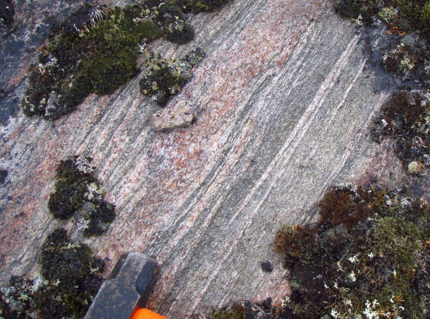 Unit Ablr1 consists of grey tonalitic gneiss containing 15-40% millimetre to centimetre-wide bands of pink granite and, more locally, 10-20% whitish bands. Gneiss is locally migmatized to varying degrees. It is medium to fine-grained and contains 5-10% ferromagnesian minerals (biotite ± hornblende ± epidote). Locally, the granitic phase dominates and contains remnants of tonalite.
Boulder Complex 2 (Ablr2): Amphibolite

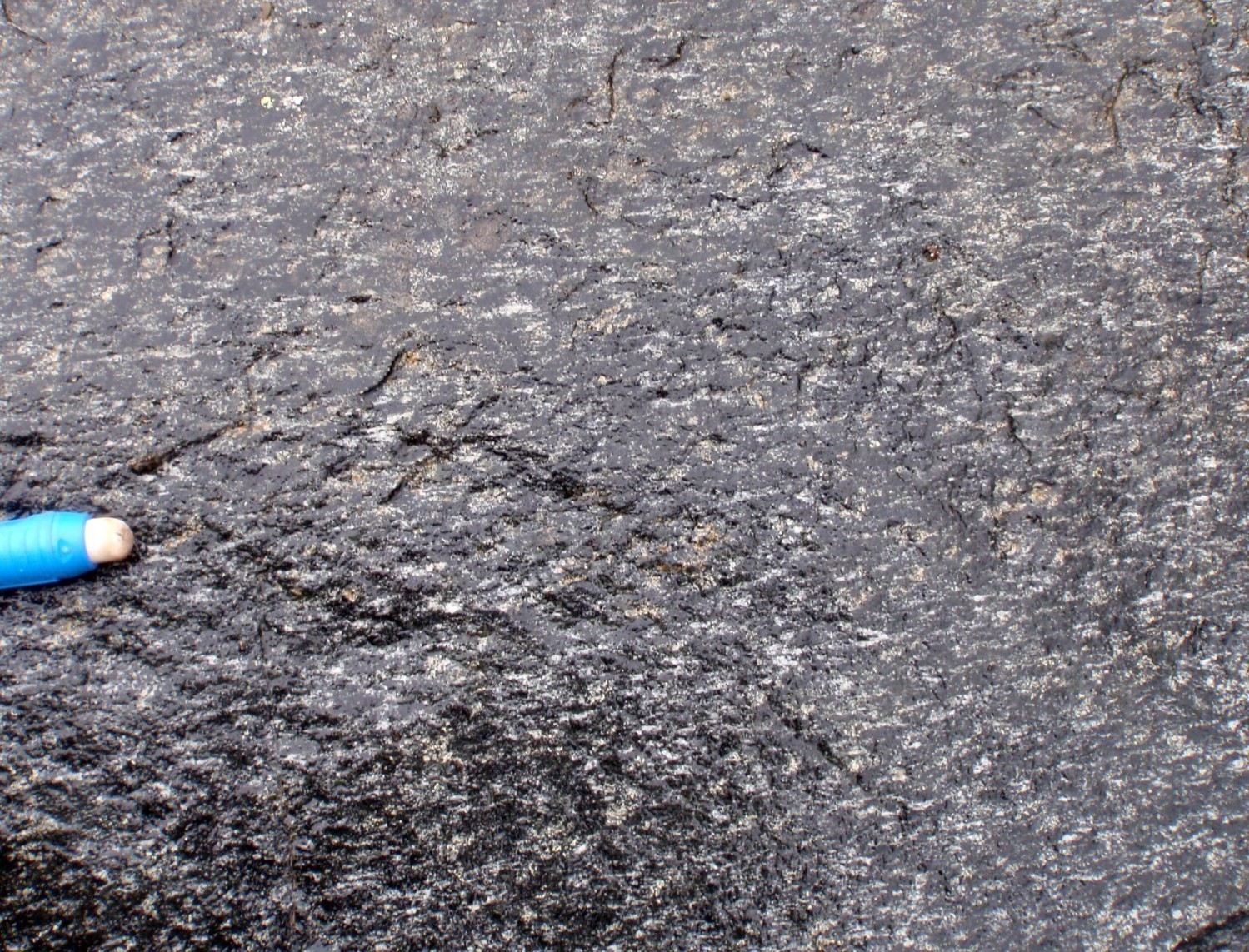 Gneiss (Ablr1) contains several layers and enclaves of hornblende-biotite amphibolite, which are derived from basalt, gabbro or diorite, and which have been grouped into unit Ablr2. Amphibolite layers are dismembered or boudinaged, usually decimetre to metre-wide but locally reaching a few hundred metres, interstratified in gneiss sequences. Amphibolite contains >60% ferromagnesian minerals, mostly hornblende, and it is well foliated, locally mylonitic.
Thickness and distribution
The Boulder Complex is located within a thrust sheet ~30 km long by 5 km wide in the Rachel-Laporte Lithotectonic Domain (Lafrance and Vanier, 2021). It is located in the axial part a large regional antiform structure oriented NW-SE and overturned towards the SW, in the south-central part of the Kuujjuaq area (sheet 24K). It covers an area of ~170 km2.
Dating
The Archean age around 2868 Ma is interpreted as that of the gneiss protolith. It is comparable to ages obtained in tonalites of the Douglas Harbour Domain (2879-2857 Ma) in the Superior Province, directly west of the Labrador Trough (Simard et al., 2008). The lithological assemblages and age of the complex are also similar to those observed in the different units of the Ungava Complex.
| Unit | Sample | Isotopic System | Mineral | Crystallization Age (Ma) | (+) | (-) | Metamorphic Age (Ma) | (+) | (-) | Reference(s) |
| Ablr1 | Boulder dome | U-Pb | Zircon | 2868 | 8 | 8 | 1783 | 11 | 11 | Machado et al., 1989 |
| Rutile | 1740 | 5 | 5 |
Stratigraphic Relationship(s)
The Boulder Complex is interpreted as a thrust sheet (Moorhead and Hynes, 1990) in fault contact with Paleoproterozoic rocks of the Laporte Supersuite. The different thrust sheets of the Rachel-Laporte Lithotectonic Domain are interpreted to have overthrusted Paleoproterozoic rocks during the New Quebec Orogenesis (1.82-1.77 Ga; Machado et al., 1989). Unit Ablr1 rocks of the Boulder Complex are similar to unit Aung3 of the Ungava Complex.
Paleontology
Does not apply.
References
Publications available through SIGÉOM Examine
LAFRANCE, I., VANIER, M.-A. 2021. Domaine lithotectonique de Rachel-Laporte, sud-est de la Province de Churchill, Québec, Canada : synthèse de la géologie. MERN; BG 2021-01
SIMARD, M., LAFRANCE, I., HAMMOUCHE, H., LEGOUIX, C., 2013. GEOLOGIE DE LA REGION DE KUUJJUAQ ET DE LA BAIE D'UNGAVA (SNRC 24J, 24K). MRN; RG 2013-04, 62 pages, 1 plan.
Other publications
GÉLINAS, L. 1965. Géologie de la région de Fort Chimo et des lacs Gabriel et Thévenet, Nouveau-Québec. Thèse de doctorat, Université Laval, Québec, 212 pages.
MACHADO, N., GOULET, N., GARIÉPY, C. 1989. U-Pb geochronology of reactivated Archean basement and of Hudsonian metamorphism in the northern Labrador Trough. Canadian Journal of Earth Sciences; volume 26, pages 1-15. https://doi.org/10.1139/e89-001
MOORHEAD, J., HYNES, A. 1990. Nappes in the internal zone of the northern Labrador Trough: Evidence for major early, NW-vergent basement transport. Geoscience Canada; volume 17, pages 241-244.
Suggested Citation
Ministère de l’Énergie et des Ressources naturelles (MERN). Boulder Complex. Quebec Stratigraphic Lexicon. https://gq.mines.gouv.qc.ca/lexique-stratigraphique/province-de-churchill/complexe-de-boulder_en [accessed on Day Month Year].
Contributors
|
First publication |
Isabelle Lafrance, P. Geo., M.Sc. isabelle.lafrance@mern.gouv.qc.ca (redaction) Mehdi A. Guemache, P. Geo., Ph.D. (coordination); Benoit Charette, P. Geo., M.Sc. (critical review); Simon Auclair, P. Ge, M.Sc. (editing); Céline Dupuis, P. Geo., Ph.D. (English version); Ricardo Escobar Moran (HTML editing). |