

Last modification:
| Author(s) | Poirier, 1989 |
| Methodology | Defined from geological surveys and geophysical data |
| Geological(s) subdivision(s) | Churchill Province / Baleine Lithotectonic Domain |
| Main movement | Reverse dextral |
| Deformation style | Thrusting followed by late dextral movement |
| Metamorphic facies (mean facies related to main deformation) | Amphibolites |
Background and Methodology
The Lac Turcotte Fault (FAtur) was first traced by Poirier (1989) during work carried out as part of a master’s project. This author considered this fault to be a major structure that constituted the eastern boundary of the “Lac Rachel – Lac Murray” block, which roughly corresponds to the Rachel-Laporte Lithotectonic Domain. According to Wardle et al. (2002) and Corrigan et al. (2018), the northern part of the Lac Tudor Shear Zone (ZCtud) gradually curves towards the NW where it joins the FAtur. The 1:250 000 scale mapping work carried out between 2011 and 2016 by the Ministère and recent geophysical surveys (D’Amours and Intissar, 2012a, 2012b, 2013; Intissar et al., 2014) did not, however, allow Lafrance et al. (2020) to link the two structures.
As part of their synthesis of the Southeastern Churchill Province (SECP), Lafrance et al. (2020) shifted the boundary between the Rachel-Laporte and Baleine domains westwards in some areas. In the northern part, this boundary now corresponds to the appearance of Archean gneiss of the Ungava Complex, which coincides in this area with the Lac Olmstead Fault (FAolm). The trace of the FAtur now joins the FAolm in the Diana Lake area (NTS sheet 24K06). The boundary between the two lithotectonic domains has also been moved westward in the southern part of the SECP. The exclusive presence of detrital zircons of Archean age in the Grand Rosoy Suite allowed Lafrance et al. (2020) to include this unit in the Baleine Domain. The FAtur was thus continued southwards along the western border of this unit.
The information available on the FAtur is limited as it is rarely exposed and the work was carried out at scale 1:250 000. Descriptions are supported by local observations.
Boundaries and Morphology
| Width | <2 km |
| Length | 684 km |
| Orientation | NNW-SSE to N-S |
The Lac Turcotte Fault is part of a system of large relay faults that mark the boundary between the Rachel-Laporte and Baleine lithotectonic domains, to the west and east respectively. In the NW part of the SECP, it is the Lac Olmstead Fault that marks this boundary, as far as the southern end of Olmstead Lake (sheet 24K06), where the FAtur takes over. In this area, the two faults are <3 km apart and parallel for ~65 km towards the SE, then the FAolm joins the FAtur. This structure has been observed sporadically in the field along its 684 km long trace. Its width is undetermined, but mylonitized layers were locally recognized up to a few kilometres on either side of the fault trace.
Stratigraphic Units Concerned
The FAtur affects units located on either side of it, along the western edge of the Baleine Domain and the eastern edge of the Rachel-Laporte Domain. These are the Akiasirviup, Curot, False, Winnie, Champdoré and Grand Rosoy suites in the Baleine Domain, and the Freneuse and Klein suites in the Rachel-Laporte Domain.
Structural Characteristics
❯ Main Fabrics
The main fabric of the FAtur is represented by planes of secondary tectonometamorphic mineral foliation Sn. This fabric is commonly folded due to the imprint of a later deformation phase (Poirier, 1989). The general orientation is NNW-SSE, except in the southern part, where it is rather N-S. As for other thrust faults (Gabriel, Lac Hérodier, Lac Olmstead, Pingiajjulik, Rachel and Pointe Reef) in the western part of the SECP, the FAtur is associated with an early NW-verging thrust phase and then folded during a subsequent deformation phase (Clark and Wares, 2004).
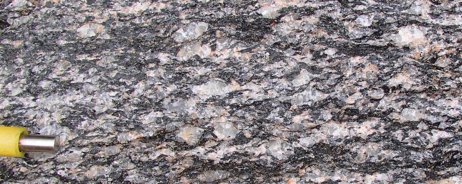
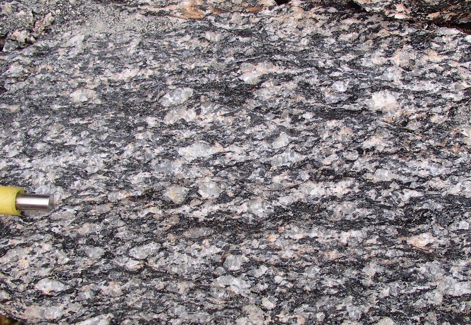 Centimetric to decametric layers of mylonite and protomylonite were locally observed along the FAtur. These more deformed layers have a protomylonitic or mylonitic planar fabric containing locally a subhorizontal stretch lineation towards the ESE, the east or the ENE. However, the number of lineation measurements is insufficient for a structural analysis. These more deformed zones contain feldspar porphyroclasts, discontinuous quartz bands and weak C/S fabrics. The leucosome of the False and Winnie suites, as well as quartz veins are boudinaged and folded in places.
❯ Other Fabrics
Not observed.
❯ Folds
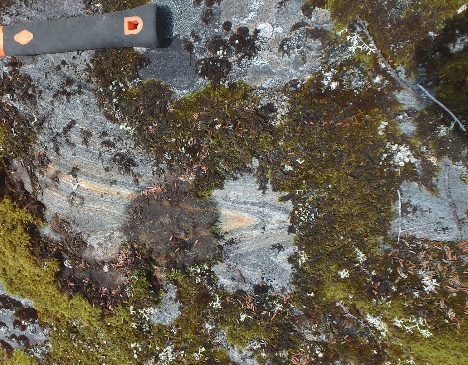
Clark and Wares (2004) attribute the development of large open NW-SE folds having shallow plunges to the SE to a late dextral strike-slip movement along large thrust faults associated with the New Quebec Orogen. According to Lafrance et al. (2020), open folds associated with this movement were observed mainly in the northern part of the Baleine Domain, whereas folds are rather tight to isoclinal in the south where they constitute an important structural element. The latter type of folds is locally observed at the scale of the outcrop along the FAtur.
Overturned folds associated with thrusting of the Baleine Domain on the Rachel-Laporte Domain during the New Quebec Orogenesis have also been described by Moorhead and Hynes (1990) in the Rénia Complex (Rachel-Laporte). These folds would have subsequently been repeated by the second phase of folding associated with the dextral strike-slip movement described above.
❯ Crosscutting Relationships
Not observed.
❯ Kinematics
The few kinematic indicators observed along the FAtur consist of plagioclase or microcline porphyroclasts and weak C/S fabrics. However, these indicators are associated with the last episode of strike-slip deformation and confirm a dextral movement.
Deformation Style
The main movement consists of thrusting followed by late dextral strike-slip. According to Perreault and Hynes (1990), the first movement would imply overthrusting of the Baleine Domain on the Rachel-Laporte Domain.
Metamorphic Characteristics
The FAtur generally marks a boundary between a less metamorphosed domain in the west and the attainment of anatexis conditions in the east (Charette et al., 2016; Godet et al., 2020a). In the northern part of Baleine Domain, this limit is represented by the Lac Olmstead Fault. Fieldwork suggests a gradual increase in the intensity of metamorphism of the Rachel-Laporte Domain as it approaches the Baleine Domain (Poirier, 1989; Perreault and Hynes, 1990). Metamorphic modelling and pretrochronology work of Godet et al. (2020) confirms that the metamorphic conditions reached are higher in the east than in the west of the FAtur, but also indicates the existence of a significant metamorphic discontinuity between the two domains. This discontinuity is revealed by the metamorphic diachronism between the Baleine and Rachel-Laporte domains, rather than by a gradient observed in the field which would reveal a gradual increase in metamorphic intensity.
In the Rachel-Laporte Domain, on the edge of the FAtur, the pressure and temperature conditions during the metamorphic paroxysm are estimated at 650°C and 0.76 GPa, whereas they are 790°C and 0.72 GPa in the central part of the Baleine Domain (Godet et al., 2020). Another sample from a more westerly area in the Rachel-Laporte Domain indicates conditions estimated at 620°C and 0.55 GPa (Godet et al., 2020).
Alterations
Metric alteration zones of hematite, epidote and silica are locally recognized in the vicinity of the FAtur. It is likely that these are late compared to the movement of the fault.
Geophysical Characteristics
The FAtur corresponds to a more or less sharply undulating magnetic lineament on the regional aeromagnetic map.
Chronological Markers
The major collision event in the western part of the SECP corresponds to the edification of the New Quebec Orogen, which occurred between 1.82 Ga and 1.77 Ga (Wardle et al., 2002). Transpressive stresses developed during this oblique collision resulted in the formation of thrust and strike-slip faults (Clark and Wares, 2004). Faults in the western part of the SECP, including the Lac Olmstead Fault, would have acted as thrust faults at the beginning of the orogenic phase, and would have been transformed into dextral strike-slip faults towards the end of the orogenic phase (Clark and Wares, 2004).
Godet et al., 2020 suggest that the FAturrepresent a tectonometamorphic discontinuity between the two lithotectonic domains from ~1830 Ma to 1800 Ma. During this period, westward thrusting of the Baleine Domain on the Rachel-Laporte Domain led to isothermal decompression of the former and amphibolite facies burial of the latter. Recent dating indicates burial of metasedimentary rocks in the Rachel-Laporte Lithotectonic Domain – located west of the Baleine Domain – under conditions of average crustal thickness at ~1804 Ma (Godet et al., 2020). This episode of thrusting and crustal thickening appears to predate the final dextral strike-slip movement, which would have occurred between 1793 Ma and 1783 Ma (Machado et al., 1989; Clark and Wares, 2008).
References
Publications Available Through Sigéom Examine
CHARETTE, B., LAFRANCE, I., VANIER, M.-A., 2016. Géologie de la région du lac Jeannin. MERN; BG 2015-01, 1 plan.
CLARK, T., WARES, R., 2004. Synthèse lithotectonique et métallogénique de l’Orogène du Nouveau-Québec (Fosse du Labrador). MRNFP; MM 2004-01, 182 pages, 1 plan.
D’AMOURS, I., INTISSAR, R., 2012a. Levé magnétique et spectrométrique aéroporté dans le secteur du lac Le Moyne, Province de Churchill. MRNF; DP 2011-06, 8 pages, 200 plans.
D’AMOURS, I., INTISSAR, R., 2012b. Levé magnétique et spectrométrique aéroporté de la rivière Koksoak, Province de Churchill. MRNF; DP 2011-07, 8 pages, 180 plans.
D’AMOURS, I., INTISSAR, R., 2013. Levé magnétique et spectrométrique aéroporté dans le secteur de la rivière à la Baleine, Province de Churchill. MRN; DP 2013-03, 10 pages, 170 plans.
DAVIS, D W., SUTCLIFFE, C N., 2018. U-Pb Geochronology of Zircon and Monazite by LA-ICPMS in Samples from Northern Quebec. University of Toronto, MERN; MB 2019-01, 113 pages.
INTISSAR, R., BENAHMED, S., D’AMOURS, I., 2014. Levé magnétique et spectrométrique aéroporté dans le secteur sud de la rivière George, partie sud-est de la Province de Churchill. MRN; DP 2014-01, 9 pages, 250 plans.
LAFRANCE, I., VANIER, M.-A., CHARETTE, B., 2020. Domaine lithotectonique de Baleine, sud-est de la Province de Churchill, Nunavik, Québec, Canada : synthèse de la géologie. MERN. BG 2020-07, 2 plans.
Other Publications
CORRIGAN, D., WODICKA, N., McFARLANE, C., LAFRANCE, I., VAN ROOYEN, D., BANDYAYERA, D., BILODEAU, C., 2018. Lithotectonic framework of the Core Zone, Southeastern Churchill Province. Geoscience Canada; volume 45, pages 1-24. doi.org/10.12789/geocanj.2018.45.128
GODET, A., GUILMETTE, C., LABROUSSE, L., DAVIS, D.W., VANIER, M.-A., LAFRANCE, I., CHARETTE, B., 2020. Contrasting P-T-t paths reveal a metamorphic discontinuity in the New Quebec Orogen: insights into Paleoproterozoic orogenic processes. Precambrian Research; article 105675. doi.org/10.1016/j.precamres.2020.105675
MACHADO, N., GOULET, N., GARIÉPY, C., 1989. U-Pb geochronology of reactivated Archean basement and of Hudsonian metamorphism in the northern Labrador Trough. Canadian Journal of Earth Sciences; volume 26, pages 1-15. doi.org/10.1139/e89-001
PERREAULT, S., HYNES, A., 1990. Tectonic evolution of the Kuujjuaq terrane, New Québec Orogen. Geosciences Canada; volume 17, pages 238-240. journals.lib.unb.ca/index.php/GC/article/view/3695
POIRIER, G.G., 1989. Structure and metamorphism of the eastern boundary of the Labrador Trough near Kuujjuaq, Québec, and its tectonic implications. McGill University; master thesis, 174 pages.
WARDLE, R.J., JAMES, D.T., SCOTT, D.J., HALL, J., 2002. The southeastern Churchill Province: synthesis of a Paleoproterozoic transpressional orogen. Canadian Journal of Earth Science; volume 39, pages 639-663. doi.org/10.1139/e02-004
Suggested Citation
Contributors
|
First publication |
Isabelle Lafrance, P. Geo., M.Sc. isabelle.lafrance@mern.gouv.qc.ca; Marc-Antoine Vanier, Jr. Eng., M.Sc. marc-antoine.vanier@mern.gouv.qc.ca, (redaction); Ghyslain Roy, P. Geo. (coordination); Claude Dion, Eng., M.Sc. (critical review); Simon Auclair, P. Geo., M.Sc. (editing); André Tremblay (HTML editing); Céline Dupuis, P. Geo., Ph.D. (english version) |