

Last modification:
| Author(s) | Poirier, 1989 |
| Methodology | Defined from geological surveys and geophysical data |
| Geological(s) subdivision(s) | Churchill Province / Baleine Lithotectonic Domain |
| Main movement | Reverse dextral |
| Deformation style | Thrusting followed by late dextral movement |
| Metamorphic facies (mean facies related to main deformation) | Amphibolites to granulites |
Background and Methodology
The Pingiajjulik Fault (FApin) was traced NE of Gabriel Lake (Poirier, 1989; Poirier et al., 1990; Perreault and Hynes, 1990), where it is considered an important structure separating two lithotectonic blocks: the Gabriel Domain to the west and the Berthet Domain to the east. For Simard et al. (2013) and Lafrance et al. (2014), this fault also marks the eastern limits of the Baie aux Feuilles and Buteux domains. Lafrance et al. (2020) did not retain these divisions in their synthesis of the Southeastern Churchill Province (SECP). For these authors, the FApin constitutes a structure within the Baleine Lithotectonic Domain.
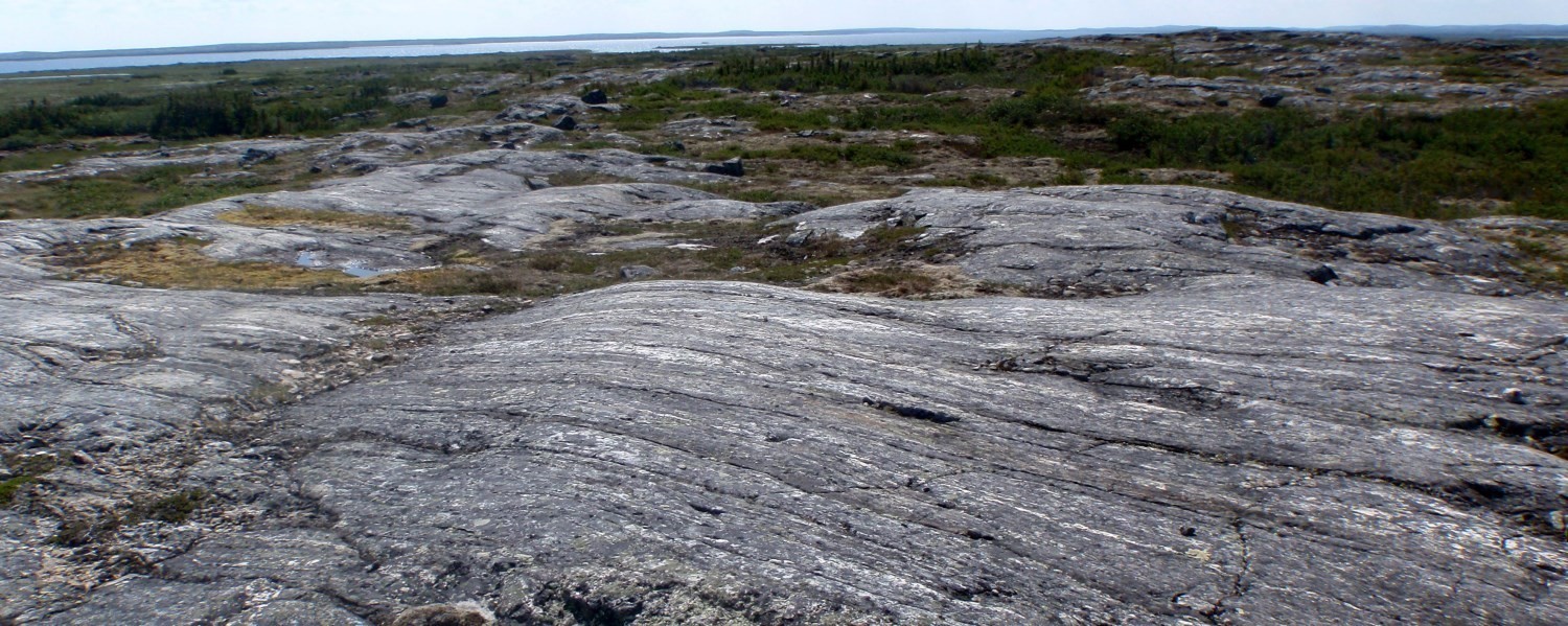
The information available on the FApin is limited as it is rarely exposed and the work was carried out at scale 1:250 000. Descriptions are supported by local studies.
Boundaries and Morphology
| Width | Undetermined |
| Length | 402 km |
| Orientation | Globally N-S |
The Pingiajjulik Fault crosses the northern half of the Baleine Lithotectonic Domain, where it generally separates Paleoproterozoic units in the west from Archean units in the east. Its 402 km long trace is folded and defines the contact of Archean units.
Stratigraphic Units Concerned
Lithodemic units affected by the Pingiajjulik Fault are the False Suite and the Kaslac, Ungava and Qurlutuq complexes.
Structural Characteristics
❯ Main Fabrics
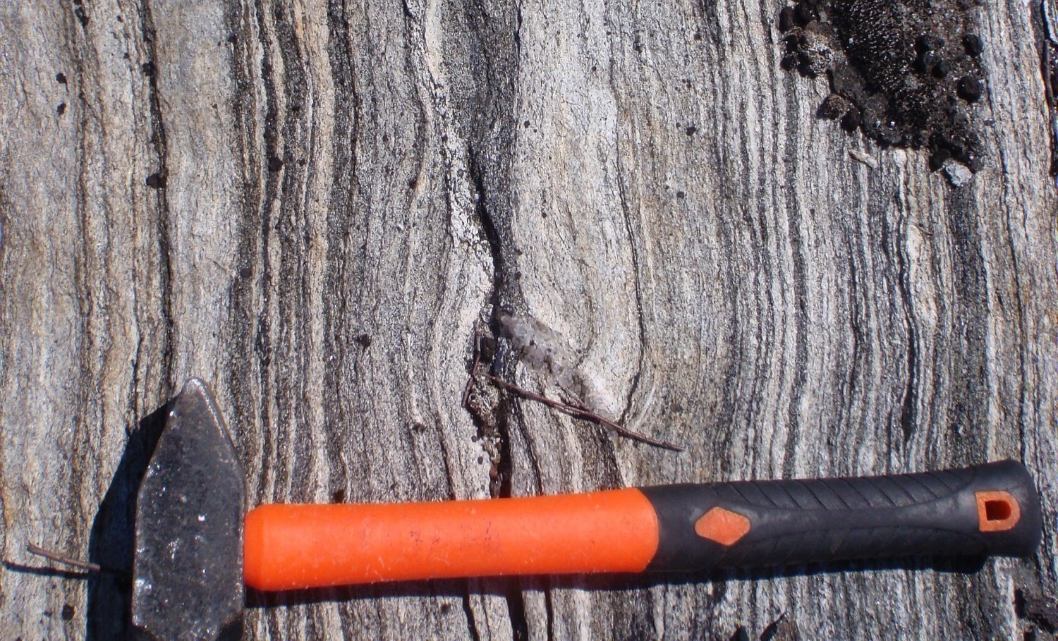 Poirier (1989) mentions that the FApin represents a large zone of highly recrystallized mylonite that separates two lithological blocks of different ages, in the area located NE of Gabriel Lake. It is characterized by well-developed mylonitic foliation or banding (Sn) and, locally, by quartz porphyroclasts and bands. Its northern and southern extensions (Simard et al., 2013; Lafrance et al., 2014) were interpreted using geophysical maps and correspond to lithological contacts between Paleoproterozoic units to the west and Archean units to the east. The structure does not outcrop much. On the other hand, rocks of the Kaslac Complex, located between the Pingiajjulik and Gabriel faults (located 5-25 km to the west), have commonly undergone intense deformation characterized by the presence of mylonitic textures and quartz bands.
The orientation of the FApin, globally N-S, is variable since it moulds the contact of lithodemic units. As with other thrust faults (Gabriel, Lac Hérodier, Lac Olmstead, Rachel, Pointe Reef and Lac Turcotte) in the western part of the SECP, the FApin would be associated with an early NW-verging thrust phase, then folded during a subsequent deformation phase (Clark and Wares, 2004).
❯ Other Fabrics
Not observed.
❯ Folds
Clark and Wares (2004) attribute the development of large open NW-SE folds having a shallow plunge towards the SE to a late dextral strike-slip movement along large thrust faults associated with the New Quebec Orogen.
❯ Crosscutting Relationships
Not observed.
❯ Kinematics
A late dextral movement was determined from pressure shadows observed around porphyroblasts (Perreault and Hynes, 1990).
Deformation Style
Thrusting followed by late dextral movement.
Metamorphic Characteristics
Rocks located to the east of the FApin are metamorphosed to the upper amphibolite facies and granulite facies. Rocks located to the west of this same structure are metamorphosed to the upper amphibolite facies. Strong recrystallization of mylonite indicates that metamorphic conditions were sufficient to allow static recrystallization after the main episode of deformation (Poirier, 1989).
Alterations
Not observed.
Geophysical Characteristics
The Pingiajjulik Fault corresponds to a more or less sharp lineament that follows the contour of lithodemic units on the regional aeromagnetic map.
Chronological Markers
The major collision event in the western part of the SECP corresponds to the edification of the New Quebec Orogen, which occurred between 1.82 Ga and 1.77 Ga (Wardle et al., 2002). Transpressive stresses developed during this oblique collision resulted in the formation of thrust and strike-slip faults (Clark and Wares, 2004). Faults in the western part of the SECP, including the Gabriel Fault, would have acted as thrust faults at the beginning of the orogenic phase, and would have been transformed into dextral strike-slip faults towards the end of the orogenic phase (Clark and Wares, 2004). Recent dating indicates burial of metasedimentary rocks in the Rachel-Laporte Lithotectonic Domain - located west of the Baleine Domain - under conditions of average crustal thickness at ~1804 Ma (Godet et al., 2020). This episode of thrusting and crustal thickening appears to predate the final dextral strike-slip movement, which would have occurred between 1793 Ma and 1783 Ma (Machado et al., 1989; Clark and Wares, 2008).
The FApin is masked in several places by Paleoproterozoic intrusive rocks of the Aveneau (1817-1811 Ma; Davis et al., 2014; 2015) and Dancelou (1805-1748 Ma; Perreault and Hynes, 1990; Davis, pers. comm., 2017; Rayner et al., 2017; McFarlane and Corrigan, pers. comm., 2017; Van Rooyen, pers. comm., 2017; Davis and Sutcliffe, 2018) suites. It therefore predates the emplacement of these intrusive suites.
References
Publications Available Through Sigéom Examine
CLARK, T., WARES, R., 2004. Synthèse lithotectonique et métallogénique de l’Orogène du Nouveau-Québec (Fosse du Labrador). MRNFP; MM 2004-01, 182 pages, 1 plan.
DAVIS, D.W., SUTCLIFFE, C.N., 2018. U-Pb Geochronology of Zircon and Monazite by LA-ICPMS in Samples from Northern Quebec. University of Toronto, MERN; MB 2019-01, 113 pages.
DAVIS, D.W., MOUKHSIL, A., LAFRANCE, I., HAMMOUCHE, H., GOUTIER, J., PILOTE, P., TALLA TAKAM, F., 2015. Datations U-Pb dans les provinces du Supérieur, de Churchill et de Grenville effectuées au JSGL en 2012-2013. University of Toronto, MERN; RP 2014-07, 56 pages.
DAVIS, D.W., SIMARD, M., HAMMOUCHE, H., BANDYAYERA, D., GOUTIER, J., PILOTE, P., LECLERC, F., DION, C., 2014. Datations U-Pb effectuées dans les provinces du Supérieur et de Churchill en 2011-2012. University of Toronto, MERN; RP 2014-05, 62 pages.
LAFRANCE, I., VANIER, M.-A., CHARETTE, B., 2020. Domaine lithotectonique de Baleine, sud-est de la Province de Churchill, Nunavik, Québec, Canada : synthèse de la géologie. MERN; BG 2020-07, 2 plans.
LAFRANCE, I., SIMARD, M., BANDYAYERA, D., 2014. Géologie de la région du lac Saffray (SNRC 24F, 24G). MRN; RG 2014-02, 51 pages, 1 plan.
SIMARD, M., LAFRANCE, I., HAMMOUCHE, H., LEGOUIX, C., 2013. Géologie de la région de Kuujjuaq et de la baie d’Ungava (SNRC 24J, 24K). MRN; RG 2013-04, 62 pages, 1 plan.
Other Publications
CORRIGAN, D., WODICKA, N., McFARLANE, C., LAFRANCE, I., VAN ROOYEN, D., BANDYAYERA, D., BILODEAU, C., 2018. Lithotectonic framework of the Core Zone, Southeastern Churchill Province. Geoscience Canada; volume 45, pages 1-24. doi.org/10.12789/geocanj.2018.45.128
GODET, A., GUILMETTE, C., LABROUSSE, L., DAVIS, D.W., VANIER, M.-A., LAFRANCE, I., CHARETTE, B., 2020. Contrasting P-T-t paths reveal a metamorphic discontinuity in the New Quebec Orogen: insights into Paleoproterozoic orogenic processes. Precambrian Research; article 105675. doi.org/10.1016/j.precamres.2020.105675
MACHADO, N., GOULET, N., GARIÉPY, C., 1989. U-Pb geochronology of reactivated Archean basement and of Hudsonian metamorphism in the northern Labrador Trough. Canadian Journal of Earth Sciences; volume 26, pages 1-15. doi.org/10.1139/e89-001
PERREAULT, S., HYNES, A., 1990 -Tectonic evolution of the Kuujjuaq terrane, New Québec Orogen. Geosciences Canada; volume 17 pages 238-240. journals.lib.unb.ca/index.php/GC/article/view/3695
POIRIER, G.G., 1989. Structure and metamorphism of the eastern boundary of the Labrador Trough near Kuujjuaq, Québec, and its tectonic implications. McGill University; master thesis, 174 pages.
POIRIER, G., PERREAULT, S., HYNES, A., LEWRY, J.F., STAUFFER, M.R., 1990. Nature of the eastern boundary of the Labrador Trough near Kuujjuaq, Quebec. In The Early Proterozoic Trans-Hudson Orogen of North America: Lithotectonic Correlations and Evolution (Lewry, J.F. and Stauffer, M.R., editors). Geological Association of Canada; Special Paper 37, pages 397-412.
RAYNER, N.M., LAFRANCE, I., CORRIGAN, D., CHARETTE, B., 2017. New U-Pb zircon ages of plutonic rocks from the Jeannin Lake area, Quebec: an evaluation of the Kuujjuaq Domain and Rachel-Laporte Zone. Geological Survey of Canada; Current Research 2017-4, 14 pages. doi.org/10.4095/306180
WARDLE, R.J., JAMES, D.T., SCOTT, D.J., HALL, J., 2002. The southeastern Churchill Province: synthesis of a Paleoproterozoic transpressional orogen. Canadian Journal of Earth Science; volume 39, pages 639-663. doi.org/10.1139/e02-004
Suggested Citation
Contributors
|
First publication |
Isabelle Lafrance, P. Geo., M.Sc. isabelle.lafrance@mern.gouv.qc.ca; Marc-Antoine Vanier, Jr. Eng., M.Sc. marc-antoine.vanier@mern.gouv.qc.ca, (redaction); Ghyslain Roy, P. Geo. (coordination); Claude Dion, Eng., M.Sc. (critical review); Simon Auclair, P. Geo., M.Sc. (editing); André Tremblay (HTML editing); Céline Dupuis, P. Geo., Ph.D. (english version) |