


Geology of the Montagnes Lake Area, La Grande, Nemiscau and Opatica Subprovinces, Eeyou Istchee James Bay, Quebec, Canada
Project for NTS sheets 32O11, 32O12 and 32O14
Daniel Bandyayera and Emmanuel Caron-Côté
BG 2019-03
Translated on 3 March 2020


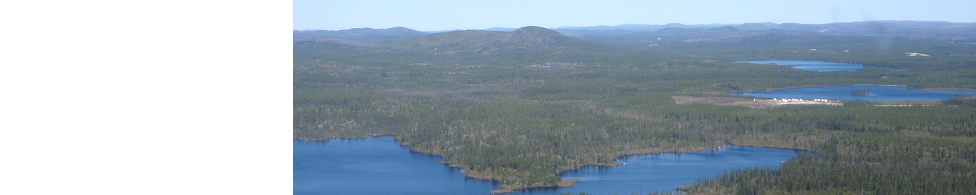
A new geological map of the Montagnes Lake area was produced at 1:50 000 scale following a survey conducted in the summer of 2018. Our work has defined several new units and subunits. The Hutte Complex forms tonalitic gneiss domes in the central part of the Nemiscau Subprovince. The Voirdye Formation groups metasedimentary rocks of the Lac des Montagnes volcano-sedimentary Belt (LMB). Horizons of tholeiitic basalt have also been recognized and assigned to the Lac des Montagnes Group. The Arques Intrusion corresponds to a strong circular magnetic anomaly. Structurally, our work has extended the Poste Albanel, Rivière Nemiscau and Rivière Rupert regional shear zones. Plutonic and gneissic rocks of the La Grande and Opatica subprovinces generally show recrystallization textures related to upper amphibolite facies conditions, whereas mineralogical assemblages of supracrustal rocks of the LMB indicate upper greenschist facies metamorphism, SW of the belt, that increases to reach the amphibolite facies towards the NE.
Methodology
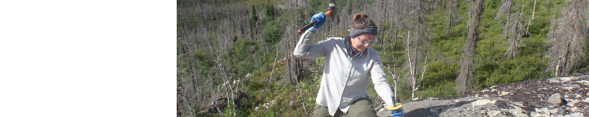
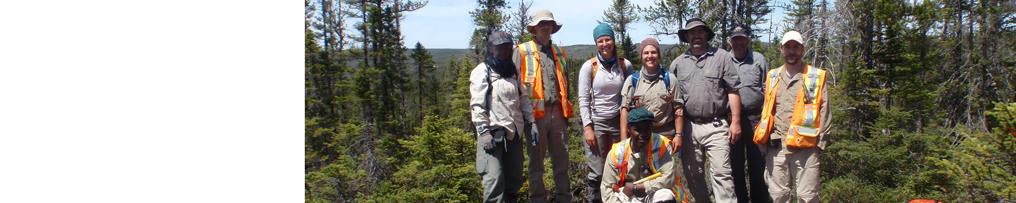
The area was mapped using the established method for surveys in isolated areas with some road access. Geological mapping was conducted by a team of six geologists and six students between June 1st and August 17, 2018. Geological mapping of the study area has produced and updated information presented in the table to the right:
| Element | Number |
|---|---|
| Described outcrop (“geofiche”) | 1281 outcrops |
| Total lithogeochemical analysis | 421 samples |
| Lithogeochemical analysis of metals of economic interest | 78 samples |
| Geochronological analysis | 6 samples |
| Covered thin section | 381 |
| Polished thin section | 15 |
| Sodium cobaltinitrite stain | 226 |
| Stratigraphic unit | 19 |
| Metallic mineralization record | 22 |
| Non-metallic mineralization record | 3 |
Previous Work
The table below lists the work that has been done in the study area since 1896. It also includes references cited in the report.
| Author(s) | Type of Work | Contribution |
|---|---|---|
| Mapping of different areas in the Montagnes Lake region | First geological cover of the study area; first areas of focus for polymetallic mineralization and industrial minerals | |
| Regional geological syntheses | Delineation of the La Grande, Nemiscau and Opatica subprovinces; identification of regional structural fabrics | |
| Detailed mapping and mining exploration | Initial mineral exploration drilling in the area; discovery of several mineralization of nickel, copper, chromium, zinc, silver, gold and platinum group elements | |
| Aeromagnetic surveys | Full coverage of the region by high-resolution aeromagnetic surveys |
Lithostratigraphy
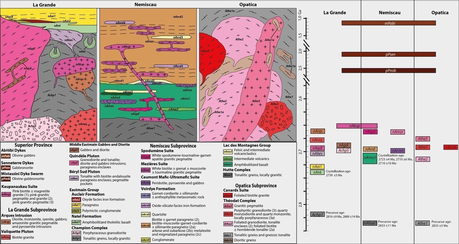
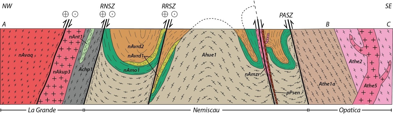
The Montagnes Lake area is in contact with three subprovinces of the Superior Province: the La Grande to the NW, the Nemiscau in the centre, and the Opatica to the southeast (Card and Ciesielski, 1986; Sawyer and Benn, 1993; Hocq et al., 1994; Benn, 2006; Percival et al., 2012). The contact between the Opatica and Nemiscau is marked by the Poste Albanel Shear Zone (PASZ), while the contact between La Grande and Nemiscau is defined by the Rivière Rupert Shear Zone (RRSZ). The stratigraphic diagram opposite shows the relationships between the different lithostratigraphic and lithodemic units of the study area.
OPATICA SUBPROVINCE
The Opatica Subprovince refers to an ensemble of Mesoarchean to Neoarchean volcano-plutonic and gneissic rocks (Benn et al., 1992; Sawyer and Benn, 1993; Davis et al., 1995; Benn and Middle, 2008; Percival et al., 2012). In the mapped area, it consists of the Théodat Complex itself composed of seven units. Tonalitic gneiss (Athe1a and Athe1b) occupy nearly one third of the Théodat Complex and represent Archean bedrock (2833 Ma; Jean David, personal communication, 2018) interpreted as the equivalent of the Rodayer Pluto intruded between 2835 and 2816 Ma (Sawyer and Benn, 1993; Davis et al., 1994; Davis et al., 1995; Percival et al., 2012; Bandyayera and Daoudene, 2017). Foliated granodiorite and tonalite (Athe2) make up almost half the surface of the Théodat Complex. Porphyritic granodiorite, granite, monzodiorite and quartz monzonite units (Athe3, Athe4 and Athe5) cut tonalite and granodiorite of unit Athe2 and are dated 2693.3 Ma (David et al., 2019a). The age of these intrusions, in addition to their petrographic and geochemical similarities, classifies them as late-tectonic porphyraceous intrusions recognized in the La Grande and Opatica subprovinces (Augland et al., 2016), which also include intrusions of the La Sicotière Suite (sheet 32N08, 2690 Ma; Jean David, personal communication, 2018). The Canards Suite groups foliated to gneissic granite and pegmatitic granite intrusions that cut the Théodat Complex, south of the Poste Albanel Shear Zone.
LA GRANDE SUBPROVINCE
The Champion Complex includes tonalitic gneiss, locally granitic (Achp1), and porphyritic granodiorite (Achp5) from the central part of the mapped area. This NE-oriented unit borders the Rivière Rupert River Shear Zone, which marks the boundary with the Nemiscau Subprovince. The emplacement of Achp1 gneiss between 2889 and 2881 Ma (Isnard and Gariépy, 2004; Bynoe, 2014) indicates that the Champion Complex probably represents Mesoarchean bedrock on which Eastmain Group volcano-sedimentary rocks have been deposited. Porphyritic granodiorite (Achp5) has strong similarities to late-tectonic porphyraceous intrusions of the Opatica Subprovince dated at ~2690 Ma (Augland et al., 2016; Jean David, personal communication 2019).
The Eastmain Group consists of mafic volcanic rocks of the Natel Formation overlain by sedimentary rocks of the Auclair Formation. The age of Natel Formation amphibolite (nAnt1, 2739 Ma; Moukhsil et al., 2003) coincides with the end of the first volcanic cycle of the Middle and Lower Eastmain Greenstone Belt (2730-2740 Ma; Moukhsil et al., 2003). Areas of amphibolite derived from tholeiitic basalt found in the Champion Complex have also been assigned to the Natel Formation. Although Moukhsil and Legault (2002) included in the Auclair Formation migmatized paragneiss of the Opinaca and Nemiscau subprovinces, our work shows that the latter only encompasses Eastmain Group sedimentary rocks. In the study area, the Auclair Formation consists of paragneiss (nAai1), polymictic conglomerate (nAai4) and oxide facies iron formations (nAai2).
The Béryl Sud (nAbes1) and Quindèle (nAqdl1) plutons intruded at the contact between the Champion Complex and Eastmain Group. They consist of tonalite and granodiorite. The Quindèle Pluton is intruded by gabbro and diorite assigned to the Moyenne Eastmain Gabbro and Diorite unit (nAgdi1). The Arques Intrusion is a new unit of late-tectonic and polyphase intermediate intrusive rocks characterized by a series of circular concentric anomalies. It was emplaced on the edge of the Rivière Rupert Shear Zone in tonalitic gneiss of the Champion Complex.
NEMISCAU SUBPROVINCE
The Hutte Complex is a new unit consisting of tonalitic gneiss that are locally granitic (2833 Ma; Jean David, personal communication, 2019) occurring as gneissic domes forming structural windows through rocks of the Lac des Montagnes volcano-sedimentary Belt (2723 Ma; Jean David, personal communication, 2019).
The Lac des Montagnes Group consists of the entire package of volcano-sedimentary rocks found within a block delineated by the Rivière Rupert and Poste Albanel shear zones. In the mapped area, the Lac des Montagnes Group includes four units of mafic to felsic rocks (nAmo1, nAmo2, nAmo3 and nAmo5) that are interstratified and folded. Basalt consists of magnesian and ferriferous tholeiites, while intermediate volcanics and volcaniclastics are of calc-alkaline affinity. Two U-Pb zircon dating from lapilli and ash tuffs of unit nAmo3 yielded crystallization ages of 2707 Ma (David 2019b) and 2723 Ma (Jean David, personal communication 2019; David 2019b).
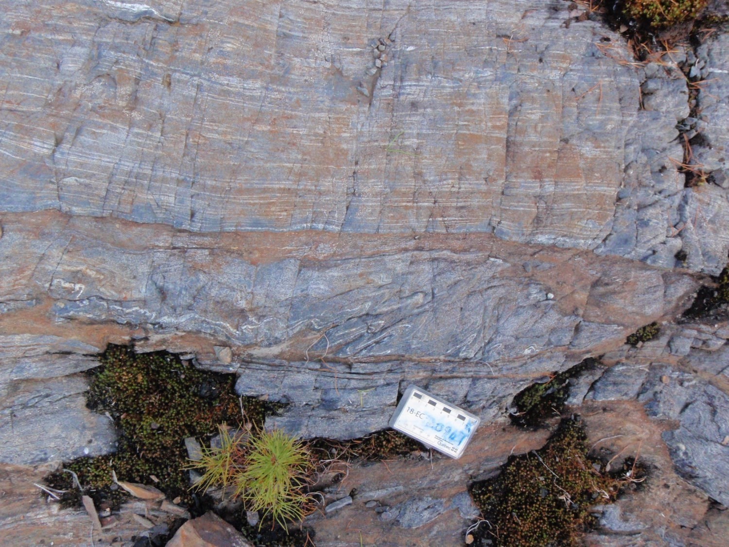
The Voirdye Formation is a new unit introduced to describe a sequence of metasedimentary rocks in the Lac des Montagnes Belt. Overlying volcanic units of the Lac des Montagnes Group, it consists of conglomerate (nAvrd1), paragneiss (nAvrd2), quartzite (nAvrd3), iron formations (nAvrd4) and metasomatic rocks (nAvrd5).
The Caumont Mafic-Ultramafic Suite groups mafic and ultramafic sills intruding into the Lac des Montagnes Group volcano-sedimentary sequence. The Lac des Montagnes Ultramafic Intrusion is the largest ultramafic stratiform intrusion of the Caumont Suite and the only one containing metre to decametre-thick zones of layered chromitite. It consists of peridotite (nAmot1), chromitite (nAmot1a), pyroxenite (nAmot2) and, incidentally, gabbro (nAmot3). This sill shows NE-SW oriented magmatic layering, as well as a steep dip and stratigraphic polarity both towards the SE.
The Mezières Suite consists of polyphase intrusions of white biotite ± garnet ± muscovite ± tourmaline granitic pegmatite. These rocks intruded between 2691 and 2672 Ma (David, 2019b; Davis et al., 1995) into Voirdye Formation metasedimentary rocks. The abundance of biotite schlierens and the ubiquitous presence of paragneiss and migmatite enclaves suggest that the Mezières Suite is the evolved product of partial melting of metasedimentary rocks.
The Spodumène Suite is a new lithodemic unit grouping intrusions of white spodumene-muscovite-garnet-tourmaline ± beryl ± apatite ± lepidolite ± petalite pegmatite that intrudes into amphibolitized basalt of the Lac des Montagnes Group. The edges of intrusions are generally deformed and sheared, suggesting a syntectonic to late-tectonic emplacement. A crystallization age of 2577 ±13 Ma obtained on zircons from the Whabouchi deposit's spodumene pegmatite (Beland, 2011) demonstrates that this unit is the latest felsic intrusive phase of the Nemiscau Subprovince.
UNITS BELONGING TO MULTIPLE SUBPROVINCES
The Kaupanaukau Suite groups late intrusions of pink granite and granitic pegmatite (nAkup1-nAkup3) that cut all the rocks of the Nemiscau Subprovince, Champion Complex and Valiquette Pluton. It corresponds to granite and granitic pegmatite units of the Théodat Complex (Athe4 and Athe5) found in the Opatica Suprovince.
Diabase Dykes
The study area is cut by three diabase dyke swarms, the NW-SE oriented Mistassini Dyke Swarm (2515 Ma), the NE-SW oriented Senneterre Dykes (2221 Ma and 2216 Ma) and the E-W oriented Abitibi Dykes (1141 Ma).
Structural Geology
At least three phases of deformation have been recognized in the study area. The first (D2) resulted in a S2 planar fabric generally oriented E-W in the Opatica and La Grande subprovinces. The second phase of deformation (D3) generated an S3 planar fabric having of average orientation equal to 240°/85°, as well as NE-SW oriented thrust faults mainly recognized in the Nemiscau Subprovince and in Opatica and La Grande rocks at the edge of shear zones limiting the Nemiscau Subprovince. These S3 structures are locally overprinted by an NNE-SSW oriented S4 fabric. Overall, these three planar fabrics could be associated with a single phase of progressive Archean deformation or separate events.
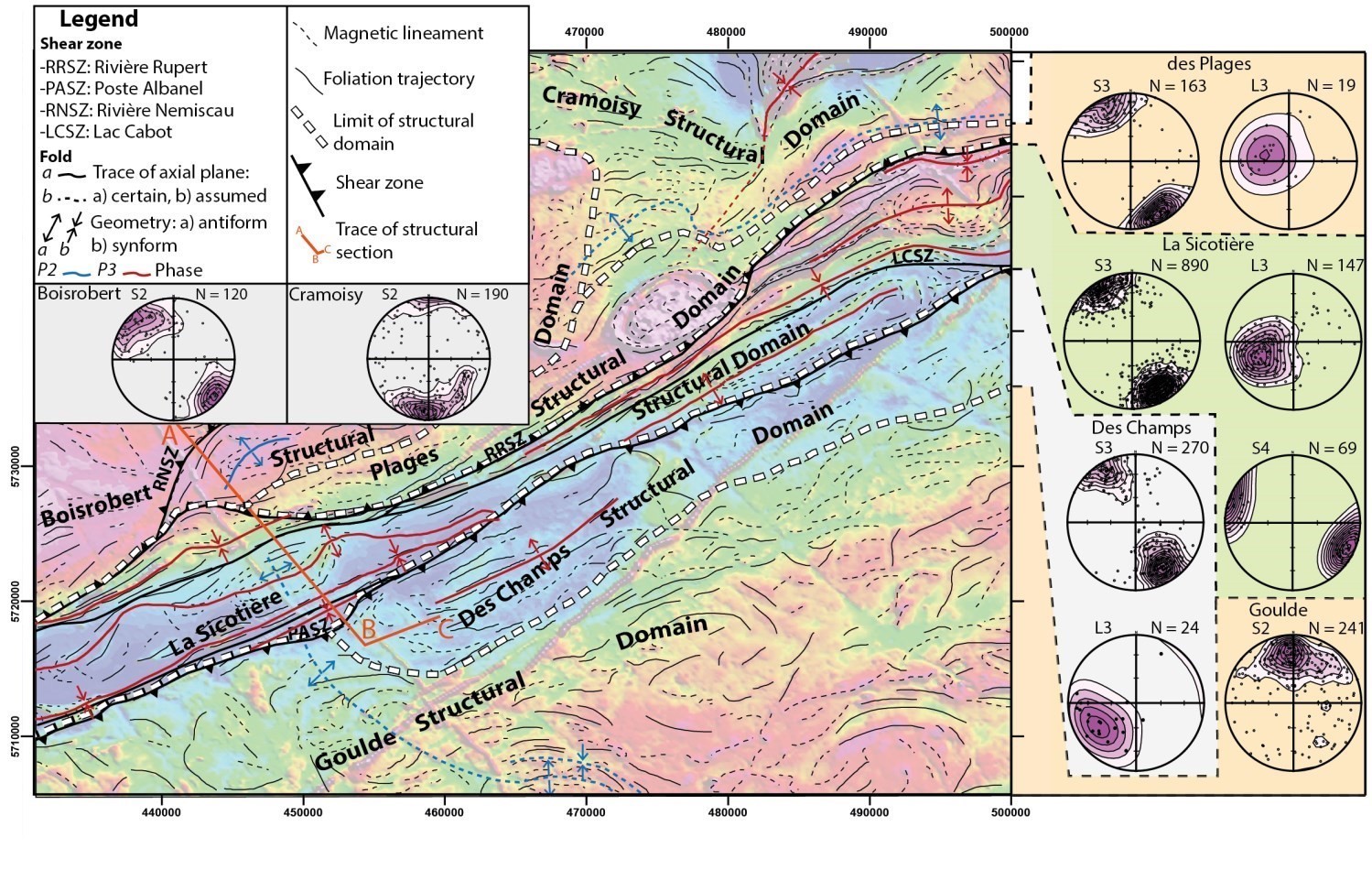
Structural Domains
The study area was divided into six structural domains based on their lithological, structural and geophysical characteristics. From north to south are the Cramoisy, Boisrobert, Plages, La Sicotière, Des Champs and Goulde domains.
The Cramoisy Structural Domain includes rocks of the La Grande Subprovince in the northern part of sheet 32O14. The S2 fabric is essentially oriented E-W and has a steep northward dip. P2 folds are overprinted by P3 folds that affect both intrusive and volcano-sedimentary rocks in the northern section of sheet 32O14.
The Boisrobert Structural Domain consists of rocks of the La Grande Subprovince in the NW portion of sheet 32O11. In the western part of the study area, it is in structural contact with the La Sicotière Domain and is separated by the Rivière Nemiscau Shear Zone (RNSZ). The foliation's orientation varies from NNE to NE.
The Plages Structural Domain is separated from the La Sicotière Domain by the Rivière Rupert Shear Zone (RRSZ). It includes unit Achp1 gneiss of the Champion Complex, which forms the basement of the La Grande Subprovince. This domain is affected by the same D3 deformation event that caused the main structures of the La Sicotière Domain. Gneissosity is transposed parallel to the NE-SW fabric of the Nemiscau Subprovince. Its steep dip is mainly towards the NW, but locally towards the SE. Lineations show a steep plunge towards the W or NW.
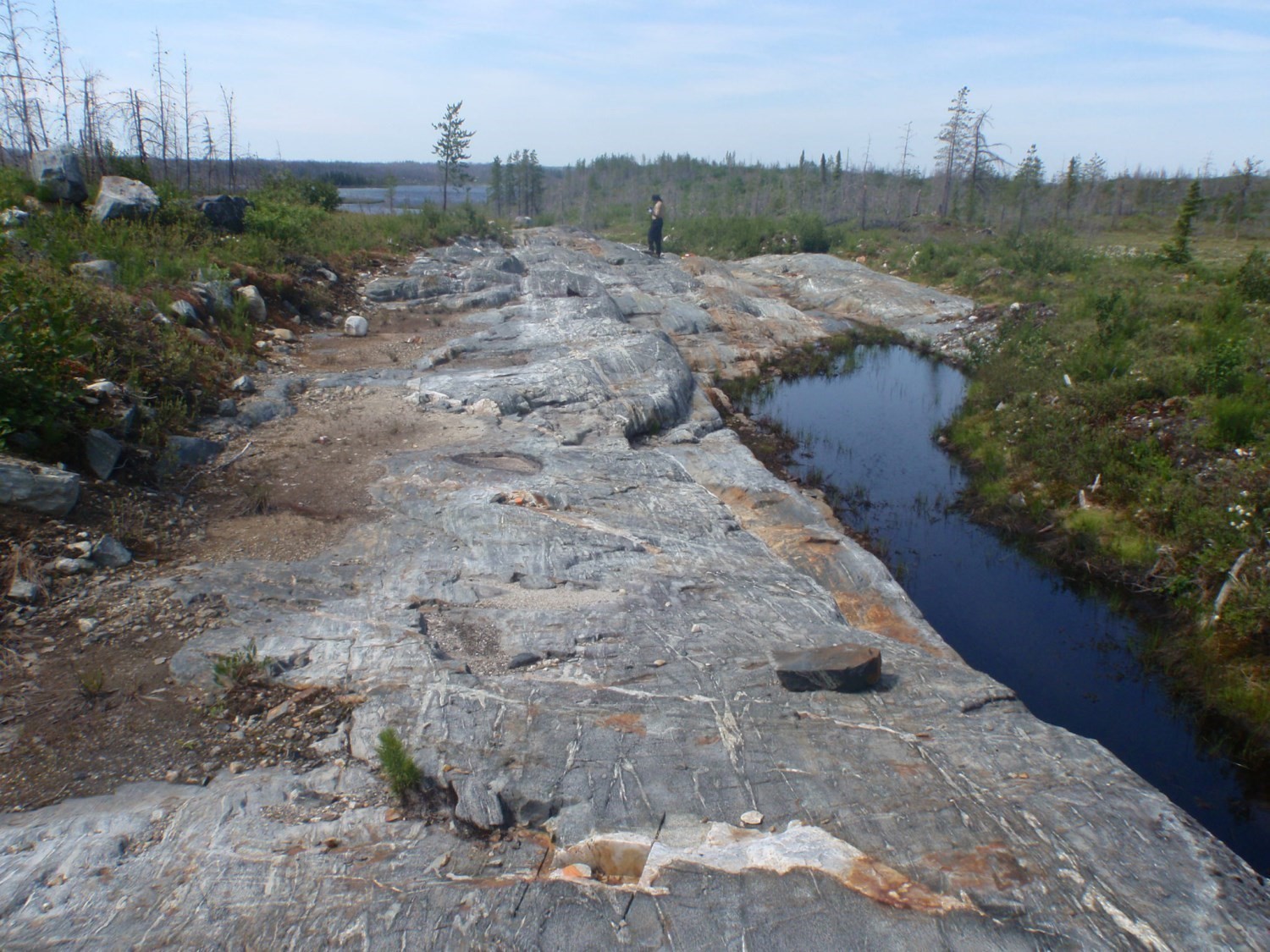
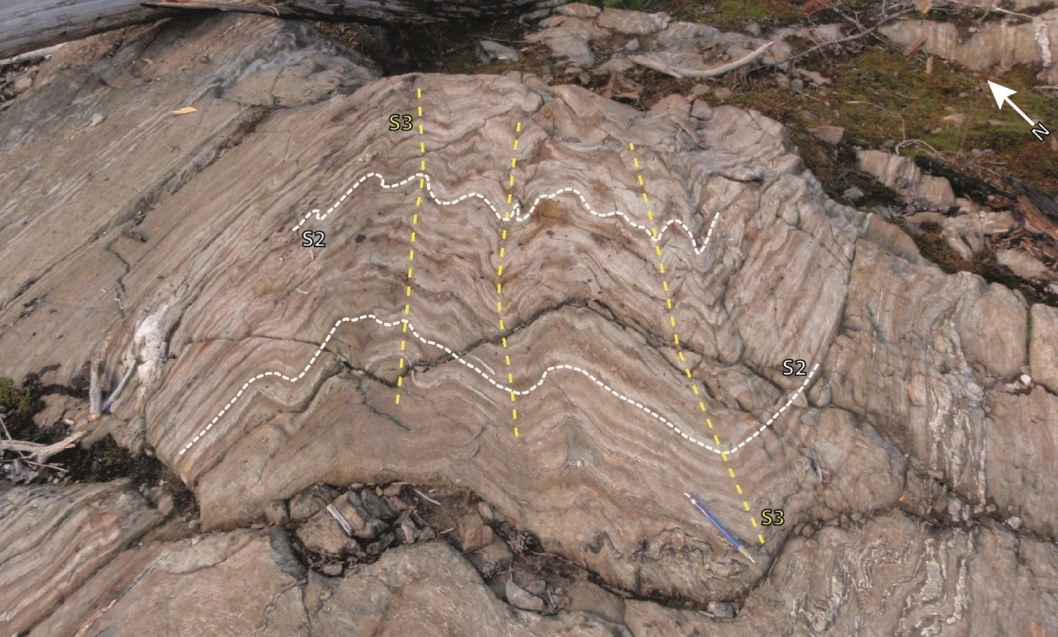 The La Sicotière Structural Domain coincides with the Nemiscau Subprovince. It is delineated by the Rivière Rupert Shear Zone (RRSZ) to the north and Poste Albanel Shear Zone (PASZ) to the south. Preserved primary structures, such as cross lamination and stratification, are commonly found in sedimentary rocks of the Voirdye Formation. Two structural fabrics associated with different deformation phases are also recognized. Bedding is transposed according to the S3 foliation, which is generally oriented 060°-240° and has a steep dip towards the NW and the SE, resulting in NE-SW axial plane P3 folds. The L3 lineation plunges 20° to 60° towards the SW. A NNE-SSW oriented crenulation cleavage affects the S3 schistosity locally.
The La Sicotière Structural Domain also contains gneissic domes (Hutte Complex) centred on P3 antiforms in the central part of the Nemiscau Subprovince. Emplacement of these domes is not well understood, as another folding phase is required to explain their formation. These rocks may have suffered the same D2 deformation that affected bedrocks of the Opatica and La Grande subprovinces. In fact, a regional antiform located in the south of the map, in the Opatica Subprovince, continues in the Nemiscau Subprovince along a NNW-SSE trend. Superimposition of this P2 antiform and a P3 antiform in the Nemiscau Subprovince could explain the formation of the dome located west of Hutte Lake. The formation of these domes could also be the result of a P4 folding phase which axial plane would be parallel and synchronous to the NNE-SSW oriented S4 crenulation cleavage (020°-200°).
The Des Champs Structural Domain is separated from the La Sicotière Domain by the Poste Albanel Post Shear Zone (PASZ). Rocks of the Théodat Complex, interpreted as Opatica bedrock, are possibly affected by the D3 deformation with structures oriented 060°-240°, parallel to those of the La Sicotière Domain. The main fabric shows moderate to steep dip, mainly towards the NW and locally towards the SE. Lineations have the same orientation as the La Sicotière Domain with an SW direction and a plunge generally ranging from 20° to 60°.
The Goulde Structural Domain includes plutonic and gneissic rocks of the Théodat Complex in the Opatica Subprovince. It is separated from the La Sicotière Domain by the PASZ. Planar structures are oriented E-W to NE-SW. Southward steeply dipping E-W fabrics predominate.
Shear Zones
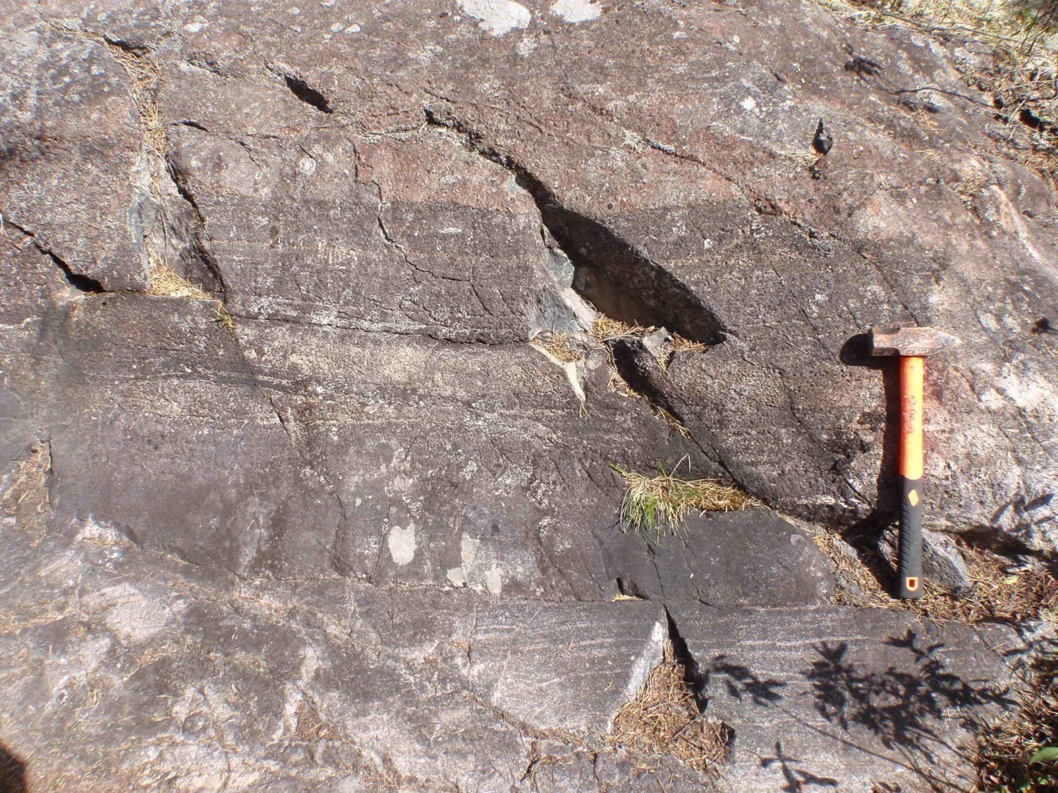
Several regional shear zones are found in the study area and have already been described (Bandyayera and Daoudene, 2018; Pedreira et al., 2018, 2019). They are mostly oriented NE-SW and show steep dips. Stretch lineations typically plunge moderately towards the SW. The majority of kinematic indicators indicate dextral component reverse movements, although local evidence of a sinistral component is observed.
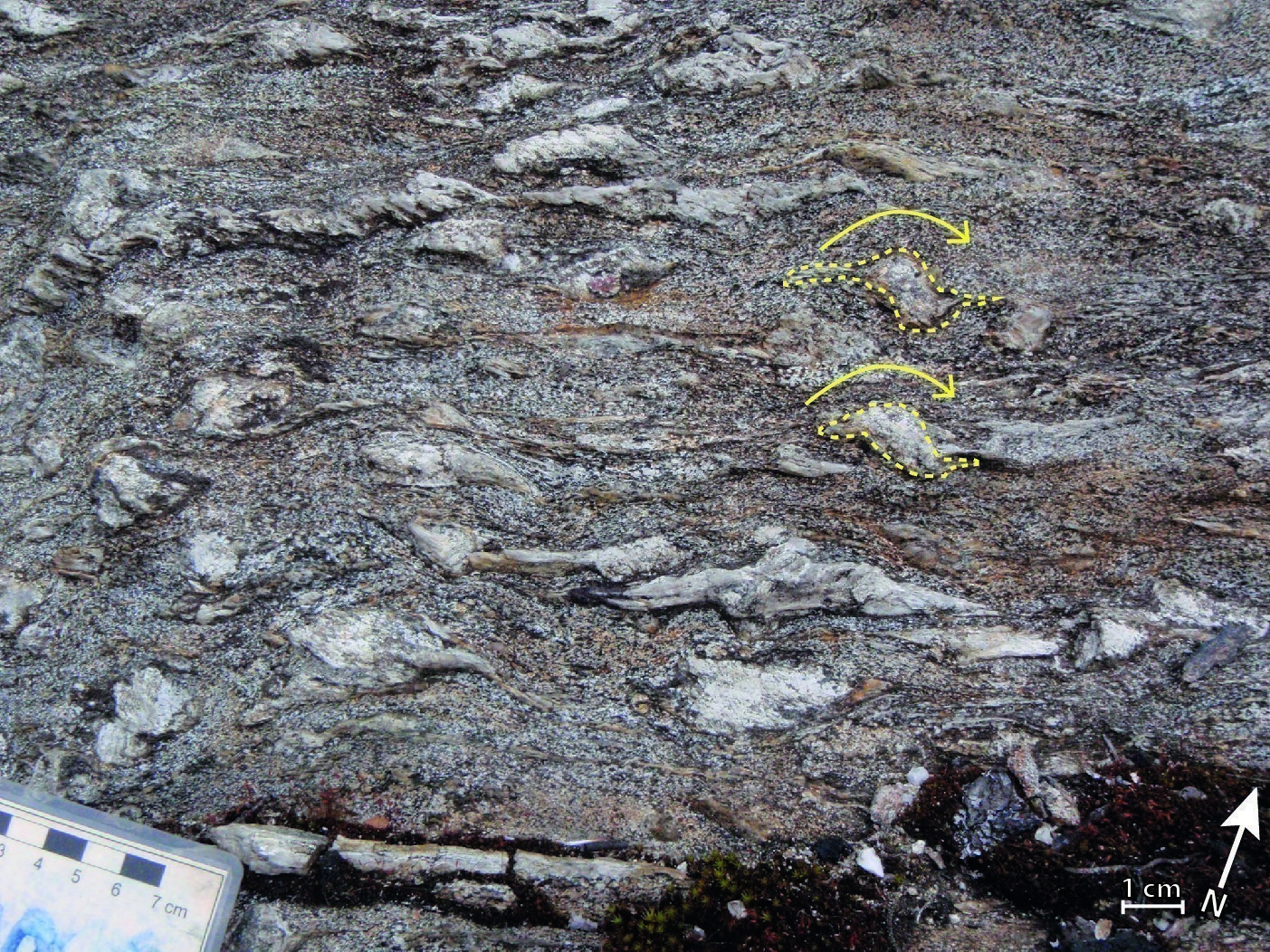 In the study area, the Rivière Rupert Shear Zone (RRSZ) delineates and affects rocks of the Nemiscau and La Grande subprovinces. Paragneiss and volcanic rocks show C/S structures and shear bands in biotite-rich horizons. Sillimanite and cordierite porphyroblasts also exhibit local sigmoid forms. Intrusive rocks show a mylonitic foliation and L-S structures. Kinematic indicators indicate a dextral component thrust apparent movement and observed lineations plunge 35 to 60° towards the SW.
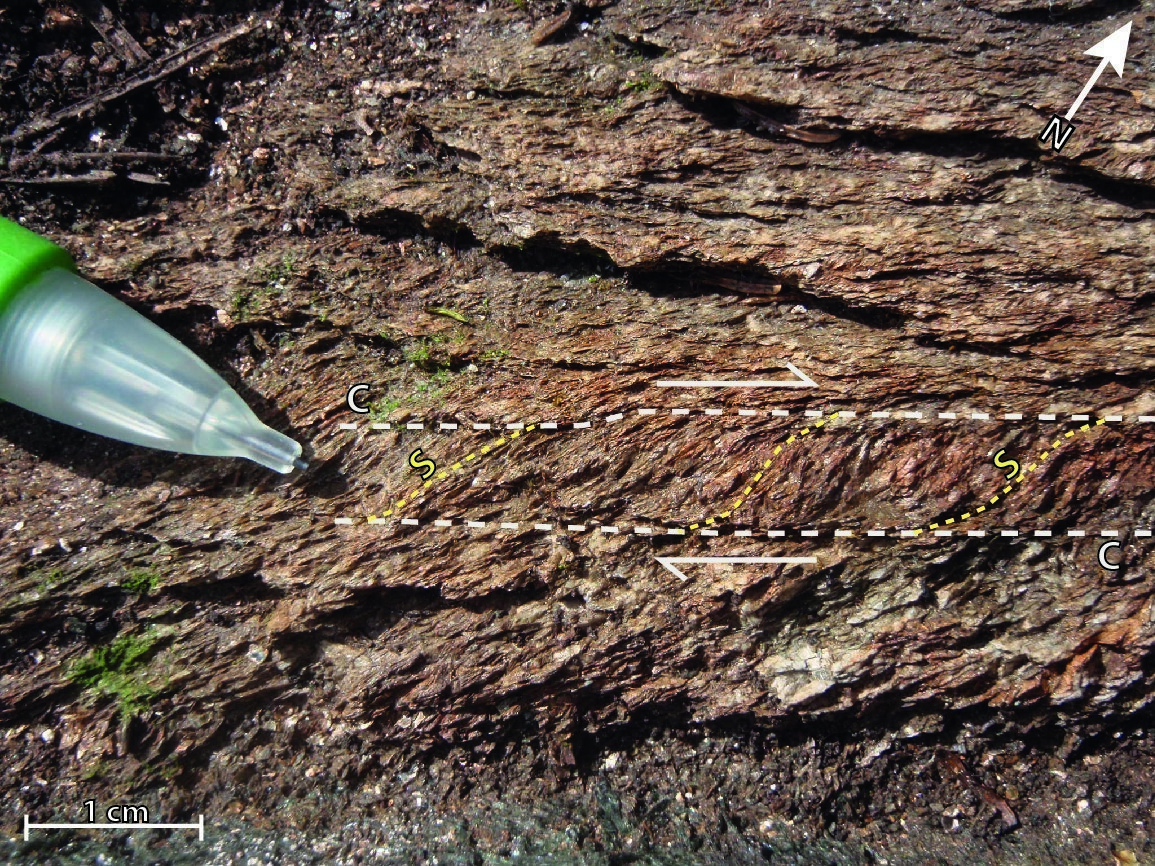 The Poste Albanel Shear Zone (PASZ) delineates and mainly affects rocks of the Nemiscau and Opatica subprovinces. Deformed rocks transformed into L-S tectonites have strong stretch lineations. These plunge 45 to 70° towards the SW. Sigmoid shapes indicate apparent dextral movement. The Rivière Nemiscau Shear Zone (RNSZ) locally marks the Nemiscau and Opatica subprovince boundary. It shows very similar characteristics to the RRSZ such as lineations having moderate plunge towards the SW and indicators of dextral component thrust kinematics.
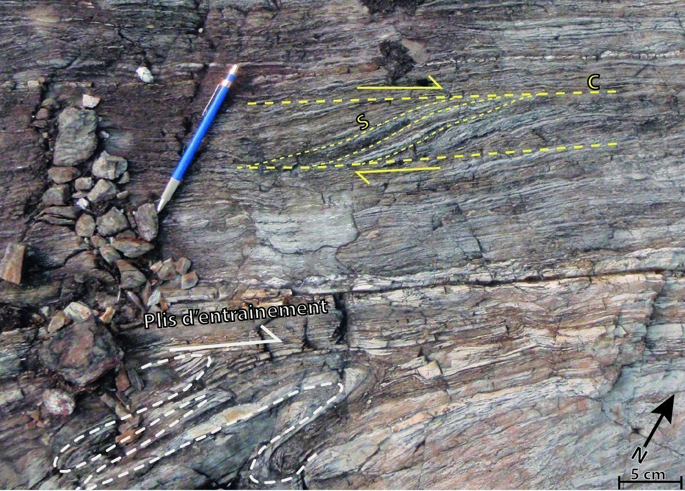 The Lac Cabot Shear Zone (LCSZ) is exclusively found within the Nemiscau Subprovince and also shows characteristics very similar to the RRSZ. However, Pedreira et al. (2019) locally observed two separate linear fabrics in the vicinity of outcrop 18-RP-6171. The first fabric is visible in mafic volcanic rocks and is associated with vertical lineations plunging towards the NW. The second, recognized in paragneiss, is accompanied by subhorizontal lineations with dextral kinematic indicators.
Metamorphism
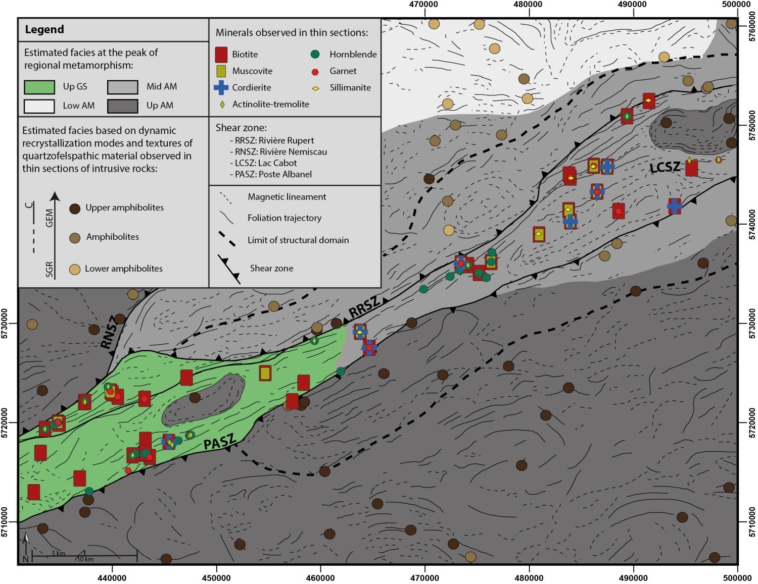
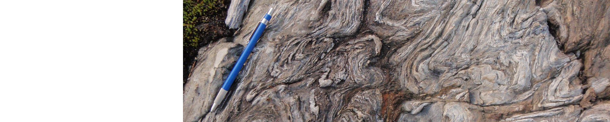
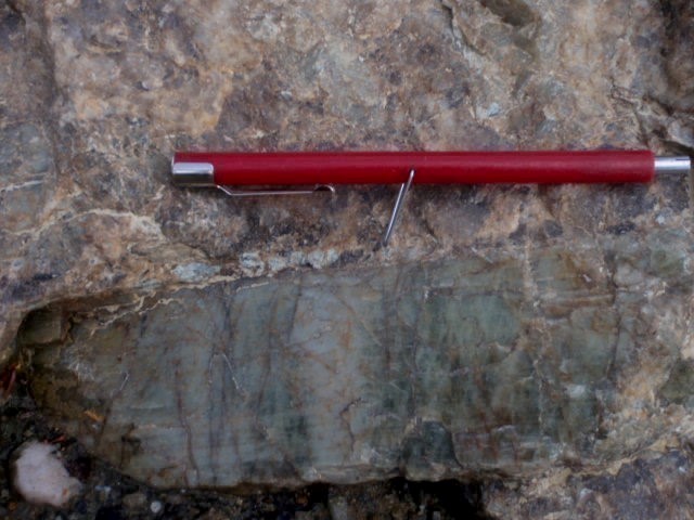
Mineralogical assemblages and recrystallizing textures observed in thin section indicate metamorphism ranging from the upper greenschist facies to the upper amphibolite facies (metamorphic map). In Nemiscau supracrustal rocks (Lac des Montagnes Group and Voirdye Formation), mineralogical assemblages suggest an increase in the intensity of metamorphism from SE to NE, from the upper greenschist facies to the middle amphibolite facies. To the SW, paragneiss show a quartz-plagioclase-biotite-garnet mineralogical assemblage, while amphibolites show a plagioclase-hornblende-actinolite assemblage. In the NE part of the Nemiscau Subprovince, paragneiss are characterized by a biotite-muscovite-cordierite-sillimanite-garnet paragenesis and amphibolites by a plagioclase-hornblende association. The presence of cordierite and sillimanite in paragneiss indicates upper amphibolite facies metamorphic conditions.
Metamorphic conditions of felsic intrusive rocks of the La Grande and Opatica subprovinces were evaluated using dynamic recrystallization modes and textures of quartzofeldspathic material (Passchier and Trouw, 1996). South of the PASZ and west of the RNSZ, as well as in Hutte Complex domes in central Nemiscau, textures suggest upper amphibolite facies metamorphic conditions. There, quartz shows a dynamic recrystallization mode dominated by grain-edge migration (GEM) and commonly shows chessboard extinctions. Feldspar is locally recrystallized by GEM, but the main recrystallizing mechanism is subgrain rotation (SGR).
North of the RRSZ and east of the RNSZ, the intensity of metamorphism appears to be decreasing, from south to north, from middle to lower amphibolite facies. This transition is marked by more moderate GEM quartz recrystallization and the disappearance of chessboard extinction. Feldspar recrystallization is still dominated by SGR.
Economic Geology
The Montagnes Lake area has prospective zones for different types of mineralization:
- magmatic Ni-Cu-Cr (± PGE ± Au) mineralization associated with mafic to ultramafic intrusions;
- base metal mineralization associated with Besshi-type volcanogenic massive sulphides;
- lithium mineralization associated with granitic pegmatites;
- gold mineralization associated with orogenic-type veins;
- gold mineralization associated with hydrothermal breccias;
- base metal mineralization associated with exhalative sulphides in sedimentary rocks (Sedex);
- gold mineralization associated with iron formations;
- disseminated and replacement gold mineralization;
- rare metal mineralization associated with rocks of intermediate composition.
The table of mineralized zones below presents analytical results for the twenty-six (26) known mineralized zones in the area.
| Name | Contents |
|---|---|
| Gold mineralization associated with orogenic-type veins | |
| Lac de la Chlorite | 10 000 ppm As over 0.6 m (R); 4760 ppb Au over 0.6 m (R) |
| Gold mineralization associated with iron formations | |
| Golden Butterfly | 7.7 g/t Ag (G); 4400 ppb Au over 5 m (D) |
| Disseminated and replacement gold mineralization | |
| Lac de la Sillimanite | 12.5% As (G); 4700 ppb Au (G) |
| Lithium mineralization associated with granitic pegmatites | |
| Graab | 720 ppm Be over 0.8 m (D); 26 800 ppm Li over 6 m (R); 2.16% Li2O over 18 m (D); 291 ppm Ta over 0.7 m (D) |
| Graab SW | 20 900 ppm Li over 1 m (R); 2.26% Li 2 O over 6.1 m (D) |
| La Baie-16824 | 282 ppb Au (G); 8470 ppm Mo (G) |
| Lac des Montagnes | 500 ppm Be over 6.4 m (D); 18 700 ppm Li over 1 m (R) |
| WHA-11-118 | >10 000 ppm Mo over 1.1 m (D) |
| Whabouchi | Measured and reported resources: 25.1 Mt at 1.54% Li2O and 140 ppm BeO; assumed resources: 4.4 Mt at 1.51% Li2O and 136 ppm BeO (Laferrière, 2011) |
| Éch.16608 | 450 ppm Be (G) |
| Rare metal mineralization associated with rocks of intermediate composition | |
| Lac Arques-SO | 1044.89 ppm Th (G); 479.06 ppm U (G) |
| RUP-11-03 | 1030 ppm Ce over 1 m (D); 1891 ppm REE over 1 m (D); 555 ppm La over 1 m (D); 25.5 ppm Nb over 1 m (D); 368 ppm Nd over 1 m (D); 835 ppm Sr over 1 m (D); 59.2 ppm Y over 1 m (D) |
| Magmatic or hydrothermal Ni-Cu-PGE mineralization | |
| Duval | 308 g/t Ag (G); 1.935 g/t Au (G); 10 000 ppm Cr (G); 65 400 ppm Cu (G); 350 ppb PGE over 3.6 m (D); 12 300 ppm Ni (G); 60 ppb Pd over 3.6 m (D); 290 ppb Pt over 3.6 m (D); 5300 ppm Zn (G) |
| Magmatic Ni-Cu mineralization associated with mafic to ultramafic intrusions | |
| Lac Valiquette | 9.6 g/t Ag (G); 1025 ppm Co (G); 10 000 ppm Cr (G); 15 800 ppm Cu over 0.3 m (R); 1741 ppb PGE (G); 26 600 ppm Ni over 3.2 m (D); 2121 ppb Pd over 0.3 m (R); 719 ppb Pt (G) |
| Nisk-1 | Measured resources: 1 255 000 t at 1.09% Ni, 0.56% Cu, 0.07% Co, 1.1 g/t Pd and 0.2 g/t Pt; reported resources: 783 000 t at 1.0% Ni, 0.53% Cu, 0.06% Co, 0.29 g/t Pt and 0.91 g/t Pd; inferred resources: 1 053 000 t at 0.81% Ni, 0.32% Cu, 0.06% Co, 0.5 g/t Pt and 1.06 g/t Pd |
| Éch. 16640 | 2320 ppm As (G); 2600 ppm Ni (G) |
| Chromite magmatic mineralization associated with mafic to ultramafic intrusions | |
| Lac des Montagnes-Sud | 303 600 ppm Cr (G); 150 700 ppm Fe (G) |
| Exhalative sulphide mineralization in sedimentary rocks (Sedex) | |
| Lac Bourier | 2.6 ppm Ag over 1.5 m (D); 11 600 ppm Zn over 0.5 m (R) |
| Besshi-type volcanogenic massive sulphide mineralization | |
| Lac Lemare-Ouest | 80.6 ppm Ag over 3 m (D); 55 600 ppm Cu (G) |
| Lac Voirdye | 11.45 ppm Ag (G); 543 ppb Au (G); 12 600 ppm Cu (G) |
| Éch. L943304 | 2.62 ppm Ag (G); 5130 ppm Cu (G); 2290 ppm Zn (G) |
| Undetermined type of mineralization | |
| Éch. 16014 | 15.5 ppm Ag (G); 1370 ppm Bi (G) |
| Éch. 753656 | 6 ppm Ag over 0.5 m (R); 2261 ppm Cu over 0.5 m (R) |
| Sillimanite mineralization | |
| Lac Rond | Paragneiss containing 25% sillimanite |
| Lac Lemare-1 | Paragneiss rich in sillimanite crystals up to 5 cm long |
| Lac Chlorite | Impure quartzite containing 45% sillimanite |
(G): Selected sample; (R): Channel–chip sample; (D): Diamond drilling
The table of lithogeochemical analyses of metals of economic interest provides the location, description, and analytical results for sixty-five (78) samples selected to assess the economic potential of the area.
Magmatic Ni-Cu-Cr (± PGE ± Au) Mineralization Associated with the Caumont Mafic-Ultramafic Suite

In the Montagnes Lake area, the Caumont Mafic-Ultramafic Suite has mineral potential for Ni-Cu-PGE ± Cr ± Au (Valiquette prospective zone). This suite consists of intrusions that are generally associated with positive magnetic anomalies. The Nisk-1b deposit and Valiquette mineralized zone are characterized by horizons of magmatic massive sulphides composed of pentlandite, chalcopyrite and pyrrhotite.
The Caumont Mafic-Ultramafic Suite also has potential for chromium mineralization (Groupe du lac des Montagnes prospective zone), as evidenced by the Lac des Montagnes-Sud mineralized zone located within the Lac des Montagnes Ultramafic Intrusion. Mineralization forms three chromitite horizons hosted in the peridotite unit. These chromite-bearing horizons consist of several centimetric to metric layers of disseminated to massive chromite (10-85% chromite).
The Voirdye Formation, a Prospective Zone for Base Metal Mineralization Associated with Besshi-Type Volcanogenic Massive Sulphides

The Voirdye prospective zone contains mineralization associated with a sequence of garnet-cordierite-sillimanite-anthophyllite metasomatized rocks. These altered rocks assigned to the Voirdye Formation are derived from clastic sedimentary rocks or felsic to intermediate volcaniclastics characterized by a strong magnetic signature. They span an area of 7.3 km x 250 m west of Lemare Lake and SE of Voirdye Lake. This sequence contains stratiform mineralization of disseminated pyrrhotite, chalcopyrite and pyrite, locally as semi-massive to massive lenses. Mineralized horizons are characterized by silicification and intense aluminous alteration marked by the abundance of garnet; they contain 30 to 50% garnet, 10 to 20% aluminosilicates and 5 to 20% sulphides.
Lithium Mineralization Associated with Granitic Pegmatites of the Spodumène Suite
The occurrence of spodumene deposits in the Montagnes Lake area has been known since the Ministère's mapping work in 1962 (Valiquette, 1963). In the Spodumène prospective zone, lithium mineralization is hosted in a white spodumene-tourmaline-garnet-apatite-muscovite granitic pegmatite intruding into amphibolitized basalts of the Lac des Montagnes Group. Metre to hectometre-thick dykes are generally oriented NE-SW and have steep dips ranging from 60° to 80°. Beryl and petalite are observed in places. Spodumene is disseminated in pegmatite with contents of 2 to 15%, locally up to 40%. Crystals generally range in size from 1 to 10 cm, but can reach 55 cm in places.
The Whabouchi deposit is the largest lithium deposit in the Nemiscau Subprovince. A total of seven lithium mineralized zones are listed in the study area.
Poste Albanel and Rivière Rupert Shear Zones Prospective for Gold Mineralization in Orogenic-Type Veins
In the Montagnes Lake area, the Poste Albanel and Rivière Rupert shear zones are prospective for orogenic-type gold-bearing veins (Chlorite prospective zone). Some areas near these shear zones contain centimetre to decimetre-thick quartz-tourmaline veins. The Lac de la Chlorite mineralized zone is the best example of orogenic-type gold mineralization in the area. Mineralization is disseminated in quartz-tourmaline-arsenopyrite veins and in their mafic volcanic host rocks.
Gold Mineralization Associated With Hydrothermal Breccias
The Hutte prospective zone consists of two hectometric hydrothermal breccia sites recognized in 2018 associated and associated with granophyric felsic intrusions or intermediate intrusions. These breccias are cut by felsic, gabbro, diabase and garnet pegmatite dykes. They contain networks of polyphase fractures that exhibit structure, intensity, density and association with felsic dykes characteristic of Au-Cu-Ag mineralization-bearing magmatic-hydrothermal systems. Some fracture networks show alteration fronts composed of biotite that may correspond to potassic alteration, while others are composed of hornblende-garnet, quartz-chlorite or quartz.
Base Metal Mineralization Associated with Exhalative Sulphides in Sedimentary Rocks (Sedex)
The Voirdye Formation includes quartzite horizons that are prospective for polymetallic (Cu-Zn-Au-Ag) mineralization associated with exhalative sulphides (Bourier prospective zone). Several metre to decametre-thick sulphide-mineralized horizons have been listed in the area (Lévesque Michaud et al., 2011; Tremblay et al., 2012). Mineralization is disseminated in quartzite or semi-massive to massive in exhalite. Some horizons of graphitic and sulphidic black shale were also observed. The Lac Bourier mineralized zone is an example of this type of mineralization in the area.
Gold Mineralization Associated with Iron Formations
The Voirdye and Auclair sedimentary formations contain Algoma-type iron formations. The Lamothe prospective zone highlights the gold potential associated with iron formations of the Auclair Formation in the southern extension of the Eastmain Group. These iron formations have polyphase folding and are cut by shear zones, reflecting a complex tectonic history. The Golden Butterfly mineralized zone is an example of this type of mineralization. Iron formations mostly are at the oxide facies and, in lesser proportions, at the silicate and sulphide facies. Gold mineralization would be linked to quartz-arsenopyrite-pyrrhotite veins and iron formation replacement (Chapdelaine and Lachance, 1998; Lanthier and St-Cyr, 1997). The best gold and silver contents come from drilling AC-97-15 which yielded 4.4 g/t Au over 5 m (Lanthier and St-Cyr, 1997) and from selected sample 22265 that contains 7.7 g/t Ag (Lanthier and Ouellette, 1996).
The Du Glas prospective zone highlights the gold potential associated with iron formations of the Voirdye Formation. These units are mainly located in sheet 32O14. They occur as decimetric to metric horizons, usually interstratified with wackes.
Disseminated and Replacement Gold Mineralization
The Sillimanite prospective zone highlights the potential for disseminated gold mineralization associated with the Voirdye Formation and the Lac des Montagnes Group. The most prominent example of this type of mineralization in the area is the Lac de la Sillimanite mineralized zone. Mineralization consists of 1 to 10% disseminated arsenopyrite, mainly hosted in quartzite. Mineralization is greater in fold hinges having N-S oriented axes. Gold contents appear to be associated with arsenopyrite and black tourmaline (Tremblay and Lalancette, 2012; Richard et al., 2012). Contents of 4.7 g/t Au were reported (Tremblay and Lalancette, 2012).
Rare Metal Mineralization Associated with Alkaline and Intermediate Rocks
The Arques Intrusion has mineral potential for rare metals (Arques prospective zone). It is located at the contact zone between the La Grande and Nemiscau subprovinces, along the RRSZ. The RUP-11-03 mineralized zone highlights the potential of the Arques Intrusion for rare earth element (REE) mineralization. Anomalous REE contents are localized in alteration zones rich in pyroxene, biotite, carbonates and chlorite (Aubin et al., 2012).
Discussions and Conclusion
The geological survey of the Montagnes Lake area resulted in a major realignment of the boundary between the Opatica and Nemiscau subprovinces. South of the study area, a large area covering sheets 32O11 and 32O12 is now associated with the Opatica Subprovince. Plutonic rocks in this area have been assigned to the Théodat Complex.
Previous work assigned the Lac des Montagnes Group to either the Nemiscau or Opinaca Subprovince (Hocq et al., 1994; Card and Ciesielski, 1986; Percival et al., 2012). Like Bandyayera and Daoudene (2018), we have assigned this group to the Nemiscau Subprovince. This new survey suggests, however, that this unit could instead be associated with the La Grande Subprovince. It contains a well-preserved metasedimentary sequence (the Voirdye Formation), very different in terms of lithology and metamorphism from those of the Rupert Complex (Nemiscau) and Laguiche Complex (Opinaca), both of which consist mainly of migmatized paragneiss, metatexite and diatexite. The Voirdye Formation would share more similarities with the Eastmain Group's Auclair Formation. The place of Lac des Montagnes Group volcanic rocks in the Nemiscau Subprovince was also discussed. Volcanic rocks of this group, although younger, can be correlated with those of the Natel Formation (Eastmain Group), located in the north, and could therefore be associated with the second volcanic cycle of the Eastmain Group. Mapping work NE of the study area is recommended to confirm this hypothesis.
The discovery of gneissic domes in the centre of the Lac des Montagnes Belt, known as the “Hutte Complex”, is also a new contribution to understanding the geology of the area. The Mesoarchean age of this unit (2833 Ma) involves synchronous crystallization to gneiss of the Théodat, Rodayer and Champion complexes (Sawyer and Benn, 1993; Davis et al., 1995; Béland, 2011; Bynoe, 2014). This raises the question of whether the La Grande and Opatica subprovinces formed separate blocks during their formation in the Mesoarchean or constituted a single terrane. We recommend that an isotopic study of Mesoarchean basement gneiss from these three subprovinces be undertaken to test this hypothesis.
In the mapped area, there is a variation in metamorphic contrast from SW to NE between structural blocks delineated by large regional fault zones. Thus, in the SW portion of the area, the Lac des Montagnes Belt exhibits greenschist facies metamorphism that strongly contrasts with the amphibolite facies metamorphism of adjacent units of the Opatica and La Grande subprovinces. The increase in metamorphic facies of rocks of the Lac des Montagnes Belt from SW to NE results in a decrease in metamorphic contrast between the subprovinces.
| Authors | Daniel Bandyayera, P.Geo., Ph.D. daniel.bandyayera@mern.gouv.qc.ca Emmanuel Caron-Côté, GIT, M.Sc. emmanuel.caron-cote@mern.gouv.qc.ca |
| Geochemistry | Fabien Solgadi, P.Geo., Ph.D. |
| Geophysics | Siham Benhamed, GIT, M.Sc. Rachid Intissar, P.Geo., M.Sc. |
| Potential assessment | Hanafi Hammouche, P.Geo., M.Sc. |
| Logistics | Clotilde Duvergier, GIT, B.Sc. |
| Geomatics | Julie Sauvageau Kathleen O'Brien |
| Template and content compliance | François Leclerc, P.Geo., Ph.D. |
| Coaching/mentoring and critical review | Patrice Roy, P.Geo., M.Sc. |
| English version | Céline Dupuis, P.Geo., Ph.D. |
| Organism | General Direction of Géologie Québec, Ministère de l'Énergie et des Ressources naturelles, Government of Québec |
Acknowledgements:
This Geological Bulletin was made possible through the cooperation of many people who have been actively involved in the various stages of the project. We thank geologist Julie Vallières, geologists-in-training Charles St-Hilaire, Rocio Pedreira Pérez and Nathalie Desjardins and students Alexane Perosa, Laura Gonzalez-Morena, Nguessan Alex de Dieu Tondoh, Jefferson Chevillet-Le Gris, Frédéric Jacques, Frédérik Croteau and Samuel Lacombe. We salute the excellent work of cook Daniel Crépeau and camp man Robert Gallant. We also thank Dany Trudel, Jonathan Aubin and Jacques Paquet from the Ministère for material preparation and installation of the camp. Ground transportation was provided by Héli-Express. Helicopter pilot Lionel Humbert and mechanic Marc Sévigny performed their duties with pleasure, efficiency and professionalism. Discussions with geologists Yannick Daoudene and Patrice Roy have been very beneficial.
References
Publications Available through Sigéom Examine
AUBIN, J., LALANCETTE, J., CARON, Y. 2012. CAMPAGNES 2011 ET 2012 DE FORAGE ET D'EXPLORATION SUR LA PROPRIETE ARQUES. RESSOURCES MONARQUES. Assessment work submitted to the Government of Québec. GM 67325, 228 pages and 12 plans.
AUGLAND, L E., DAVID, J., PILOTE, P., LECLERC, F., GOUTIER, J., HAMMOUCHE, H., LAFRANCE, I., TALLA TAKAM, F., DESCHENES, P.L., GUEMACHE, M. 2016. Datation U-Pb dans les provinces de Churchill et du Supérieur effectuées au GEOTOP en 2012-2013. MERN, GEOTOP. RP 2015-01, 43 pages.
BANDYAYERA, D., DAOUDENE, Y. 2017. Géologie de la région du lac Rodayer (SNRC 32K13-32K14-32N03 et 32N04-SE). MERN. RG 2017-01, 60 pages and 2 plans.
BANDYAYERA, D., DAOUDENE, Y. 2018. Géologie de la région du lac Nemiscau, secteur ouest de la rivière Rupert (SNRC 32N06, 32N07 et 32N11). MERN. RG 2018-03, 58 pages and 1 plan.
CHAPDELAINE, M., LACHANCE, S. 1998. RAPPORT TECHNIQUE DES SONDAGES, AUTOMNE 1998, PROJET AUCLAIR. MINES D'OR VIRGINIA. Assessment work submitted to the Government of Québec. GM 56493, 137 pages and 4 plans.
DAVID, J. 2019a. Datations U-Pb dans la Province du Supérieur effectuées au GEOTOP en 2015-2016. Ministère de l’Énergie et des Ressources naturelles, Québec; MB 2018-16.
DAVID, J. 2019b. Datations U-Pb dans les provinces de Grenville et du Supérieur effectuées au GEOTOP en 2016-2017. Ministère de l’Énergie et des Ressources naturelles, Québec; MB 2018-17.
D'AMOURS, I. 2011a. Levé magnétique aéroporte de la partie sud-est de la Sous-province de Nemiscau et de la partie nord de la Sous-province d'Opinaca, Baie-James, Québec. MRNF. DP 2011-02, 8 pages and 92 plans.
D'AMOURS, I. 2011b. Synthèse des levés magnétiques de la Baie-James. MRNF. DP 2011-08, 5 pages and 2 plans.
DESBIENS, H. 1997. GEOLOGIE DE LA PROPRIETE NEMISCAU. MINES ET EXPLORATION NORANDA INC. Assessment work submitted to the Government of Québec. GM 55737, 74 pages and 4 plans.
HOCQ, M., VERPAELST, P., CLARK, T., LAMOTHE, D., BRISEBOIS, D., BRUN, J., MARTINEAU, G. 1994. Géologie du Québec. MRN. MM 94-01, 172 pages.
LAFERRIÈRE, A., 2010. NI 43-101 Technical report mineral resource estimation, Whabouchi lithium deposit. Exploration Nemaska. Assessment work submitted to the Government of Québec. GM 66007, 159 pages.
LANTHIER, G., OUELLETTE, J.-F. 1996. RAPPORT DES TRAVAUX, ÉTÉ 1996, PROJET AUCLAIR. MINES D'OR VIRGINIA. Assessment work submitted to the Government of Québec. GM 54301, 197 pages and 14 plans.
LANTHIER, G., ST-CYR, R D. 1997. RAPPORT SOMMAIRE FORAGE, PROJET AUCLAIR. MINES D'OR VIRGINIA. Assessment work submitted to the Government of Québec. GM 55430, 441 pages and 39 plans.
LAVALLEE, J., RIOUX, P. 2017. WORK REPORT ON THE LEMARE PROPERTY. CORPORATION ELEMENTS CRITIQUES. Assessment work submitted to the Government of Québec. GM 70093, 320 pages and 11 plans.
LEVESQUE-MICHAUD, M., RICHARD, L.P., BUSSIERES, Y. 2011. TRAVAUX ETE-AUTOMNE 2010, PROPRIETES LAC ARQUES ET LAC LEVAC. EXPLORATION NEMASKA. Assessment work submitted to the Government of Québec. GM 65731, 285 pages and 6 plans.
MOUKHSIL, A., LEGAULT, M., BOILY, M., DOYON, J., SAWYER, E., DAVIS, D.W. 2003. Synthèse géologique et métallogénique de la Ceinture de roches vertes de la Moyenne et de la Basse-Eastmain (Baie-James). MRN. ET 2002-06, 57 pages and 1 plan.
MOUKHSIL, A., LEGAULT, M. 2002. Géologie de la région de la Basse-Eastmain occidentale. MRN. RG 2002-09, 32 pages and 4 plans.
PEDREIRA PEREZ, R., DAOUDENE, Y., TREMBLAY, A., BANDYAYERA, D. 2018. Étude structurale et métamorphique du secteur du lac Nemiscau, Sous-province de Nemiscau, Baie-James, Québec : évolution tectonique d'un bassin sédimentaire. Résultats préliminaires. UQAM, MERN. MB 2018-10, 55 pages.
PEDREIRA PEREZ, R., TREMBLAY, A., DAOUDENE, Y., BANDYAYERA, D. 2019. Étude structurale du secteur sud-est de la Sous-province de Nemiscau, Baie-James, Québec; preliminary results. UQAM, MERN. MB 2019-07, 68 pages.
RICHARD, L.P., LALANCETTE, J., TREMBLAY, P. 2012. CAMPAGNE DE DECAPAGE AUTOMNE 2012, PROPRIETE LEMARE. RESSOURCES MONARQUES. Assessment work submitted to the Government of Québec. GM 67424, 220 pages and 3 plans.
TREMBLAY, P., LALANCETTE, J. 2012. CAMPAGNE D'EXPLORATION, ETE 2012, PROPRIÉTÉ LEMARE. RESSOURCES MONARQUES. Assessment work submitted to the Government of Québec. GM 67326, 217 pages and 4 plans.
TREMBLAY, P., LALANCETTE, J., LEVESQUE MICHAUD, M., RICHARD, L.P. 2012. DRILLING PROGRAM 2011, DUVAL PROPERTY. RESSOURCES MONARQUES. Assessment work submitted to the Government of Québec. GM 66537, 127 pages and 9 plans.
VALIQUETTE, G. 1963. GEOLOGIE DE LA REGION DU LAC DES MONTAGNES, TERRITOIRE DE MISTASSINI. MRN. RP 500, 12 pages and 1 plan.
VALIQUETTE, G., 1975. Rapport géologique, région de la rivière Nemiscau. MRN; RG 158, 171 pages, 3 maps.
Other Publications
BELAND, C. 2011. Geochemistry and Geochronology of the Whabouchi Pegmatite Dykes as Revealed Through Zircon. University of Toronto; Bacchelor's Thesis, 103 pages. Source.
BENN, K. 2006. Tectonic delamination of the lower crust during late Archean collision of the Abitibi-Opatica and Pontiac terranes, Superior Province, Canada. In Archean Geodynamics and Environments (Benn, K., Condie, K.C., Mareschal, J.C., editors). American Geophysical Union; Geophysical Monograph 164, pages 267–282. doi.org/10.1029/164GM17.
BENN, K., MOYEN, J.F. 2008. The late Archean Abitibi-Opatica terrane, Superior Province: a modified oceanic plateau. In When did plate tectonic begin on planet Earth (Condie, K.C., Pease, V., editors). Geological Society of America; Special Paper 440, pages 173–197. doi.org/10.1130/2008.2440(09).
BENN, K., SAWYER, E.W., BOUCHEZ, J.-L. 1992. Orogen parallel and transverse shearing in the Opatica belt, Quebec: implications for the structure of the Abitibi Subprovince. Canadian Journal of Earth Sciences; volume 29, pages 2429–2444. doi.org/10.1139/e92-191.
BYNOE, L. 2014. Shear zone influence on the emplacement of a giant pegmatite: The Whabouchi lithium pegmatite, Québec, Canada. University of Western Ontario; Master's thesis, 136 pages. Source.
CARD, K.D., CIESIELSKI, A. 1986. Subdivisions of the Superior Province of the Canadian Shield. Geoscience Canada; volume 13, pages 5-13. Source.
DAVIS, W.J., GARIÉPY, C., SAWYER, E.W. 1994. Pre-2.8 Ga crust in the Opatica gneiss belt: A potential source of detrital zircons in the Abitibi and Pontiac subprovinces, Superior Province, Canada. Geology; volume 22, pages 1111–1114. doi.org/10.1130/0091-7613(1994)022<1111:PGCITO>2.3.CO;2.
DAVIS, W.J., MACHADO, N., GARIÉPY, C., SAWYER, E.W., BENN, K. 1995. U-Pb geochronology of the Opatica tonalite-gneiss belt and its relationship to the Abitibi greenstone belt, Superior Province, Quebec. Canadian Journal of Earth Sciences; volume 32, pages 113–127. doi.org/10.1139/e95-010.
ISNARD, H., GARIÉPY, C. 2004. Sm-Nd, Lu-Hf and Pb-Pb signatures of gneisses and granitoids from the La Grande belt: Extent of late Archean crustal recycling in the northeastern Superior Province, Canada. Geochimica et Cosmochimica Acta; volume 68, pages 1099–1113. doi.org/10.1016/j.gca.2003.08.004.
PASSCHIER, C.W., TROUW, A.J. 1996. Microtectonics. Springer-Verlag, 289 pages.
PERCIVAL, J.A., SKULSKI, T., SANBORN-BARRIE, M., STOTT, G.M., LECLAIR, A.D., CORKERY, M.T., BOILY, M. 2012. Geology and tectonic evolution of the Superior province, Canada. Chapter 6. In Tectonic styles in Canada: The Lithoprobe perspective (Percival, J.A. Cook, F.A., Clowes, R.M., editors). Geological Association of Canada; Special Paper 49, pages 321–378.
SAWYER, E.W., BENN, K. 1993. Structure of the high-grade Opatica Belt and the adjacent low-grade Abitibi Subprovince, Canada: an Archean mountain front. Journal of Structural Geology; volume 15, pages 1443–1458. doi.org/10.1016/0191-8141(93)90005-U.
BANDYAYERA, D., CARON-CÔTÉ, E., 2019. Geology of the Montagnes Lake Area, La Grande, Nemiscau and Opatica Subprovinces, Eeyou Istchee James Bay, Quebec, Canada. MRNF; BG 2019-03, 2 plans.