

Last modification: 30 september 2024
| Author(s) | Beauchamp, 2020 |
| Methodology | Defined from geological survey and geophysical data |
| Geological(s) subdivision(s) | Superior Province/Opatica Subprovince |
| Main movement | Does not apply |
| Deformation style | Polyphase folding |
| Metamorphic facies (mean facies related to main deformation) | Amphibolites |
Background and Methodology
The Dolent Structural Domain was defined by Beauchamp (2020) following a mapping survey conducted in the Cadieux Lake area in the summer of 2018, in conjunction with an analysis of the regional aeromagnetic survey (D’Amours, 2011) and detailed magnetic maps (Wade et al., 2014). It is superimposed on the western branch of the Upper Eastmain Greenstone Belt (UEGB) and on the Cadieux Suite. Chartier-Montreuil et al. (2025) extended the boundaries of the domain to include the entire UEGB, using aeromagnetic maps by Benahmed and Intissar (2016) and Cleven et al. (2020), as well as mapping works by Talla Takam and Beauchamp (2016), Beauchamp et al. (2018) and Beauchamp (2020). The domain takes its name from the Dolent Lake, located directly north of the western branch of the UEGB (NTS sheet 33A08).
Boundaries and Morphology
| Width (km) | 0.5 to 12 |
| Length (km) | 115 |
| Orientation | ENE-WSW elongation |
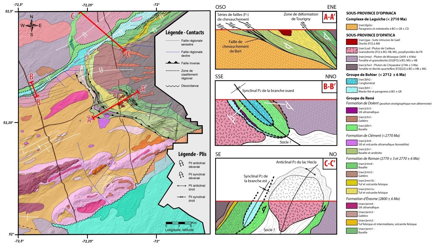
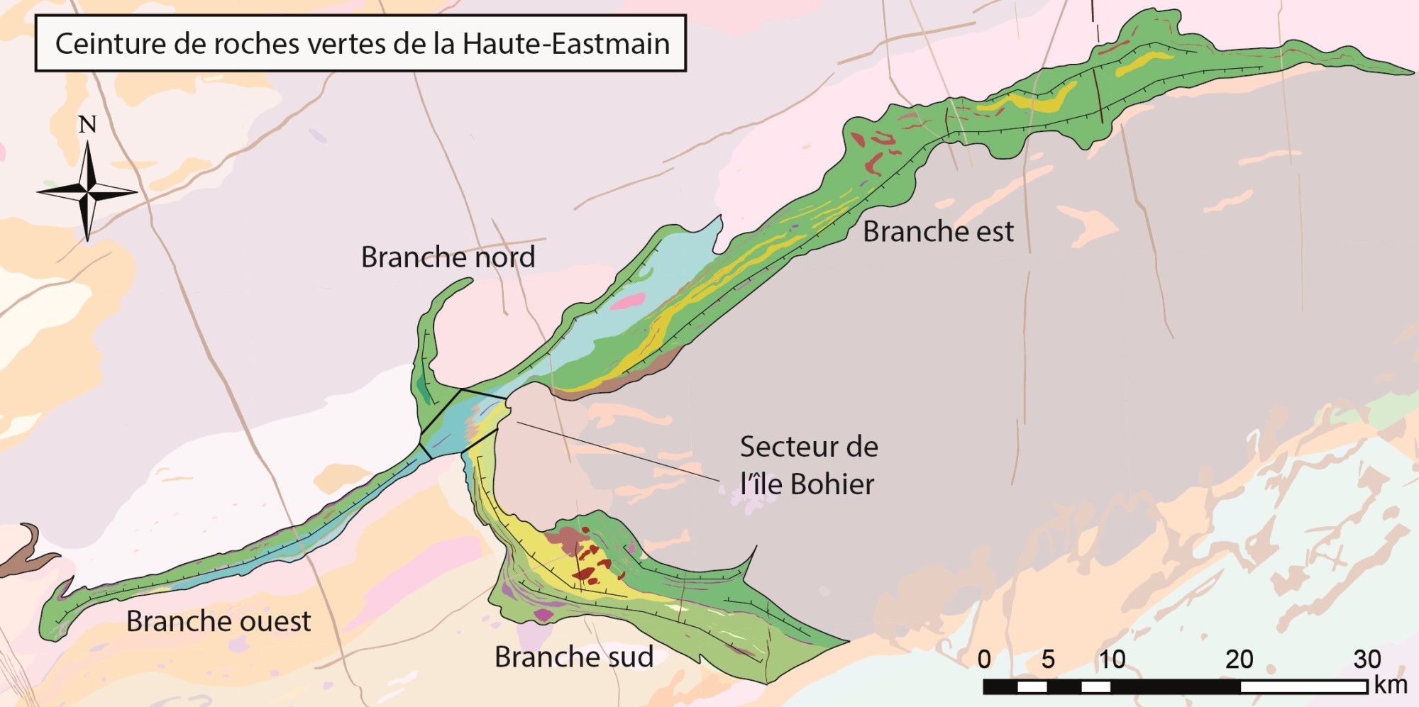 The Dolent Structural Domain is defined by the UEGB, which bears witness to a complex geological evolution. It is made up of four branches that are connected in the centre of sheet 33A08, in the Bohier Island area. The two largest branches trend mainly ENE-WSW to NE-SW, while the other two trend NNW-SSE to NW-SE. In the interest of simplicity, they will be referred to as the northern, southern, eastern and western branches. The western branch is bounded to the north by the Digne Shear Zone, separating the Dolent Formation (UEGB) volcanic rocks and the Digne Pluton in the Cadieux Structural Domain. The southern contact of this branch is also sheared, separating the UEGB rocks from those of the Cadieux Suite. At its SW end, the domain undulates due to regional folding. The eastern branch is wedged between the Wahemen Structural Domain to the north and the Chiyaaskw Structural Domain to the south. Both are composed of later plutonic rocks. The northern branch, measuring 12 km in length, moulds itself to a Cadieux Suite pluton. The southern branch is bounded by the Bart Fault to the SW and by the Chiyaaskw Structural Domain to the NE.
Stratigraphic Units Concerned
The lithostratigraphic and lithodemic units that make up the Dolent Structural Domain are listed here:
- the René Group (Are), which includes:
- the Érasme Formation (mAerm);
- the Roman Formation (nArmn);
- the Clément Formation (nAcln);
- the Dolent Formation (nAdln);
- the Bohier Group (nAbh);
- the Cadieux Suite (nAcad);
- the Bohier Island Pluton (nAibo);
- the Gaël Intrusive Suite (nAgae);
- the Wahemen Suite (nAwah);
- the Dominique Ultramafic Suite (nAdmq).
Structural Characteristics
❯ Main Fabrics
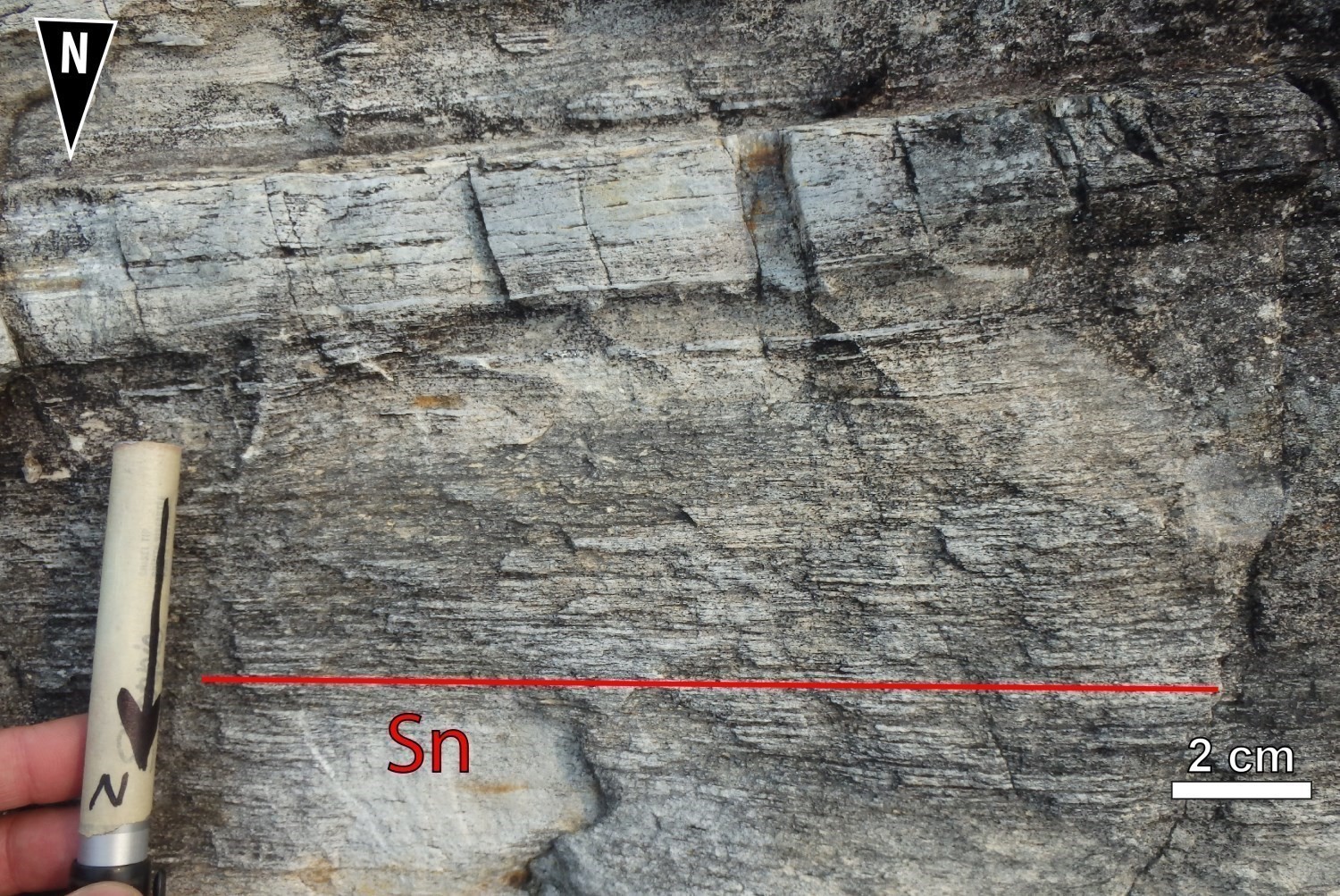 The dominant planar fabric of the Dolent Structural Domain is the Sn foliation, which results from the regional Dn deformation phase. The Sn foliation affects most Archean units in the domain, with the exception of the late intrusive rocks of the Wahemen Suite and Dominique Ultramafic Suite. This highly penetrative foliation is distinguished by the millimetric spacing between flattening planes. Whether in volcanic rocks of the Dolent Formation or in metasedimentary rocks of the Bohier Group, the Sn foliation is marked by the preferential orientation of ferromagnesian minerals such as biotite and hornblende. In areas that have accommodated a large amount of deformation, it is also marked by the flattening of quartz and feldspar grains.
 The Dolent Structural Domain shows a clear dichotomy in its main fabric. The rocks of the eastern and northern branches are affected by an ENE oriented Sn foliation with a moderate dip to the SSE, whereas the western and southern branches of the UEGB show an E-W oriented Sn foliation with a moderate dip to the north. This difference appears to have been caused by the juxtaposition of UEGB rocks and adjacent late plutons, such as the Chiyaaskw Pluton to the east, a Cadieux Suite pluton to the north, the Digne Pluton to the west and the Bohier Island Pluton to the south. In the extreme west of the domain, there is an undulating Sn fabric caused by the closure of synformal and antiformal Pn folds. The UEGB has accommodated more deformation than the adjacent rocks and is characterized by moderate to high deformation. The structural complexity of the Bohier Island area, where all four branches of the UEGB meet, can be attributed to the presence of several fabrics. Here, the regional Sn fabric is oriented ENE-WSW.
 The types of deformation affecting rocks in this area are dominated by flattening and stretching. Sedimentary rocks of the Bohier Group have accommodated deformation better than volcanic rocks and mafic-ultramafic sills of the René Group. The banded appearance of polymictic metaconglomerate is caused by a very high degree of flattening of the clasts. In places, the rock forms L-S tectonites. The deformation is so intense that clasts are very difficult to identify. Basalt pillows of the Dolent Formation are also very flattened, implying the loss of indicators of stratigraphic polarity. Near the southern contact of the UEGB, pillows are so flattened that they are locally difficult to recognize. They form bands of 10 cm to 20 cm in thickness by 0.5 m to 1 m in length. Pillow closures are clearly visible from the side (outcrop 18-AB-1040).
In intrusive rocks of the Cadieux Suite, the Sn foliation is well developed and defined by the alignment of phyllosilicates (biotite and white mica) and hornblende in spaced flattening planes. As deformation rate increases, K-feldspar porphyroids are flattened in the direction of Sn.
| Main Fabric | Type of Fabric | Direction (°) | Dip (°) | Number of Measurements | Comments |
| Sn foliation | Penetrative tectonometamorphic foliation and schistosity | 56 | 22 | 404 | Two families of measurements can be distinguished, corresponding roughly to the eastern and western parts of the UEGB. |
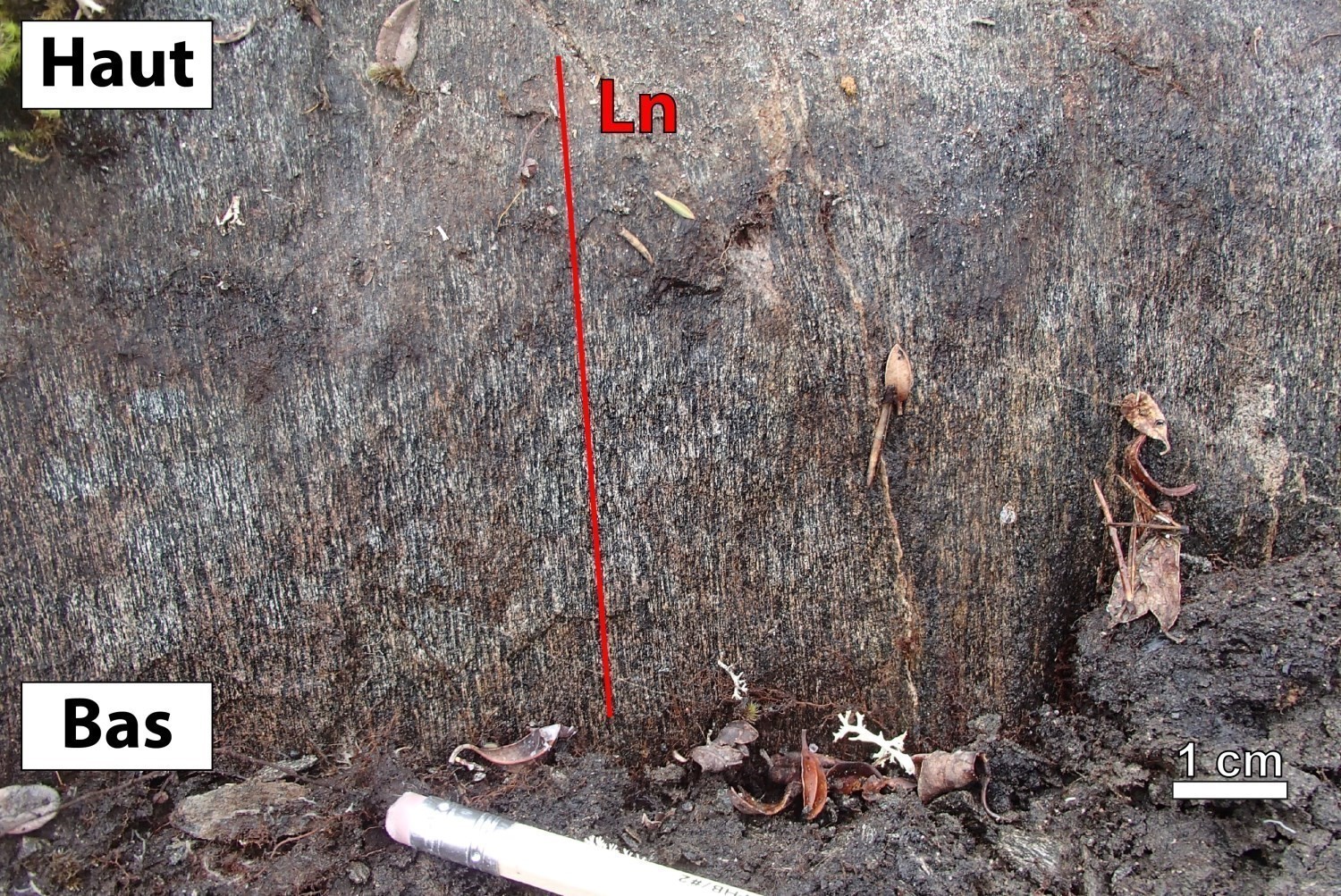
| Ln lineation | Mineral lineation and stretching lineation | 114 | 73 | 160 |
Highly variable measurements with an ESE trend |
❯ Other Fabrics
 In addition to the Sn fabric, S0 stratification as well as Sn-1 and Sn+1 fabrics were observed in the Dolent Domain.
1) Early Fabrics
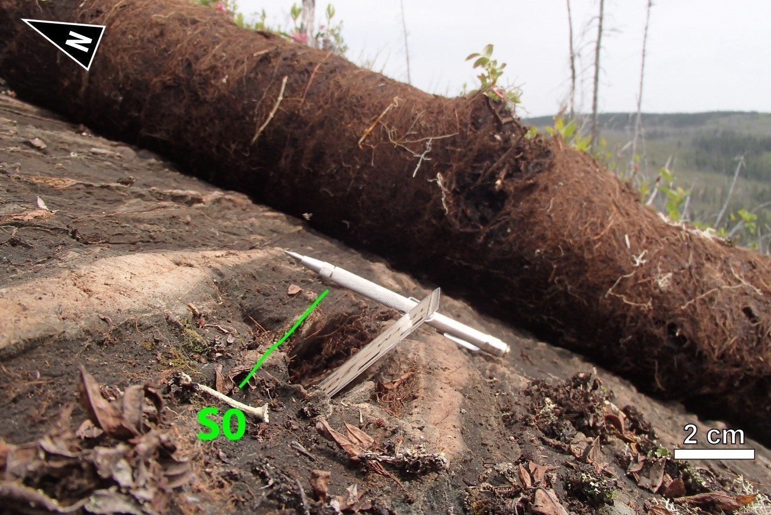 S0 fabric: S0 stratification was observed locally in the Dolent Domain. It was identified by the orientation of pillows (peduncles), quartz chambers in the René Group basalt and compositional banding in the Bohier Group conglomerate. Indicators of stratigraphic polarity in basalt indicate that the volcanic sequence has been reversed. At the base of the stratigraphy are mafic and ultramafic (intrusive and volcanic) rocks. They are overlain by basalt. The core of the western branch syncline is occupied by polymictic conglomerate from the Bohier Group, which unconformably overlie (masked by a fault) volcanic rocks of the René Group.
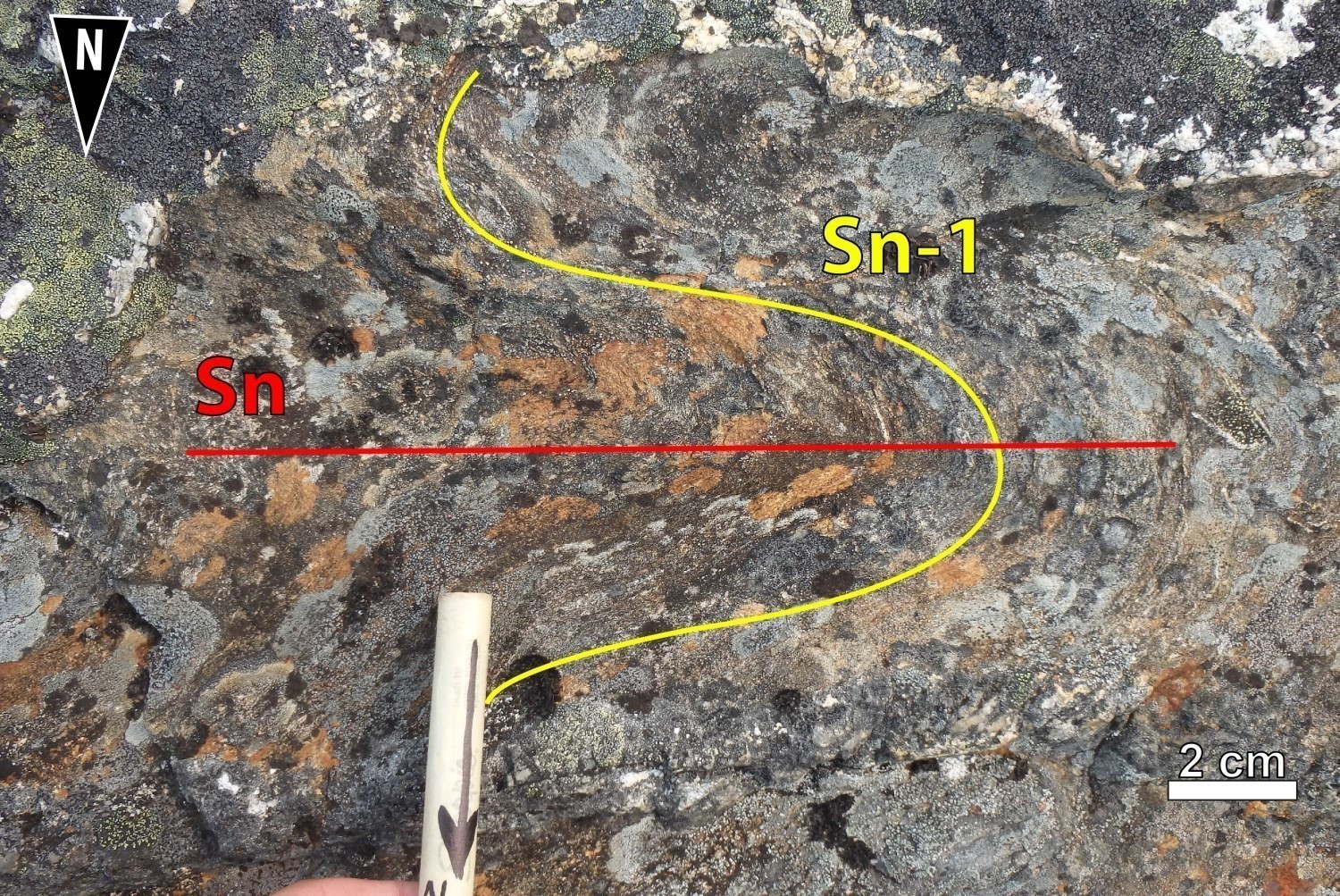
Sn-1 fabric: Sn-1 foliation is marked by the preferential orientation of ferromagnesian minerals such as biotite and hornblende. Between lakes Lépante and Digne, S0 stratification and Sn-1 fabric both seem to be transposed into the Sn fabric or at least reoriented almost parallel to Sn. At the western end of the domain, where the UEGB bevels, there is an angularity between Sn-1 and Sn fabrics. This angularity exists as the result of the succession of regional Pn fold hinges. Both Sn-1 and Sn foliations are present at outcrops 18-AB-1044 and 18-MP-5127. In the hinge of Pn regional synform (Oriental Anticline), the Sn-1 fabric’s direction varies from 30° to 310°. It is folded by a Pn fold whose Pn fabric axial plane is oriented WSW-ENE. In the Bohier Island area, the Sn-1 fabric and Ln-1 stretching lineation have been clearly identified in the centre of Bohier Island in nodular paraschist (nAbh1a) (Beauchamp et al., 2018).
2) Late Fabrics
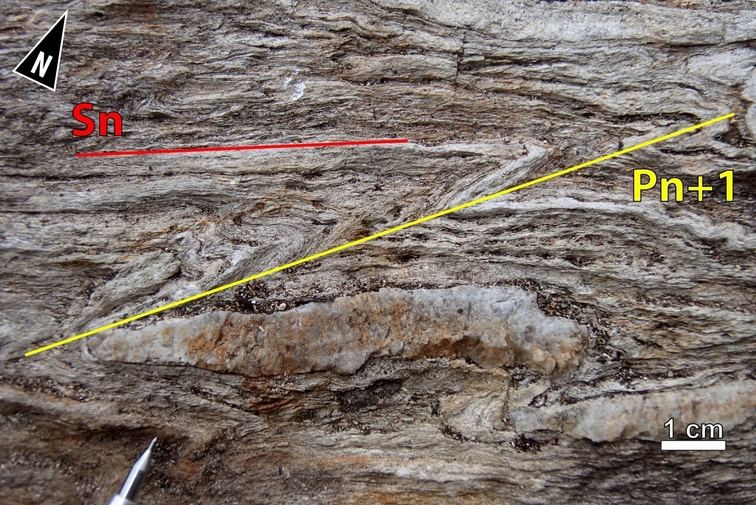
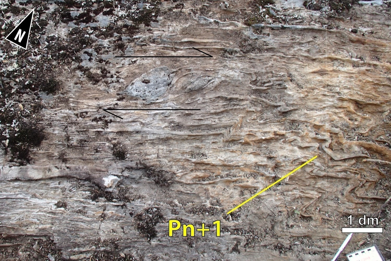
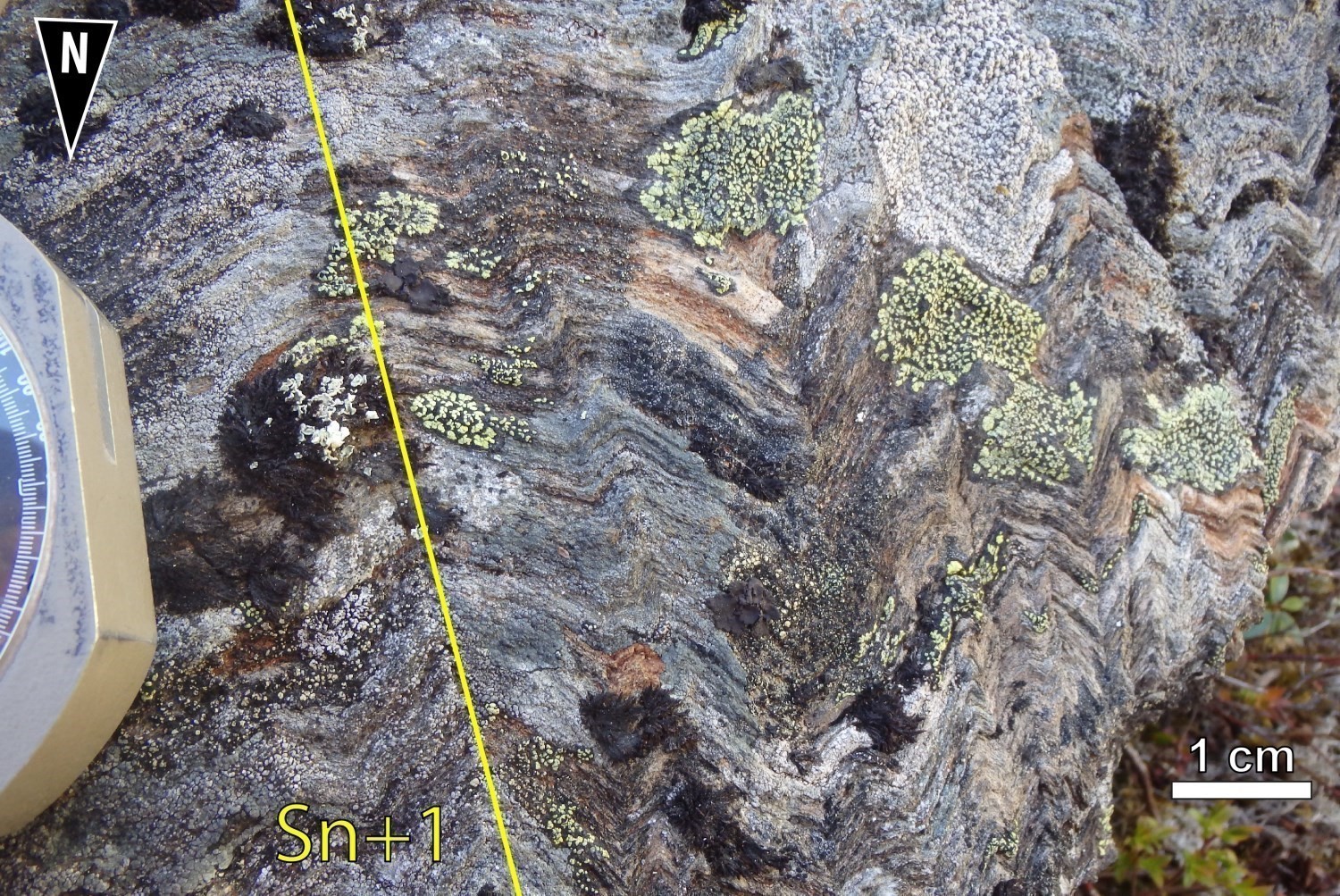 Sn+1 fabric: Sn foliation is picked up by a Sn+1 crenulation cleavage. The Sn+1 fabric is clearly visible on most conglomerate outcrops and on some basalt outcrops. This crenulation cleavage, with flattening planes ~1 cm apart, is oriented NNE-SSW. Pn+1 folds having NNE-SSW axial planes form Z-shaped structures (outcrops 18-MP-5030, 18-AB-1084, 18-SG-7023,18-SG-7024, 18-FM-2018 and 18-LP-6027).
❯ Folds
The western end of the Dolent Structural Domain is affected by a succession of several open to isoclinal regional Pn folds. Reverse polarities in pillow basalts of the Dolent Formation indicate increasingly younger layers on either side of the Oriental Anticline. The western branch represents a synclinal fold overturned towards the SE and plunging to the NE. The core of the western branch syncline is occupied by polygenic conglomerate of the Bohier Group (<2712 ± Ma; Davis and Sutcliffe, 2018b), which unconformably overlie volcanic rocks of the René Group.
This fold continues into the eastern branch, where the sequence rotates and overturns towards the NW, with an NE plunge. Its trace is lost, masked by the intrusions of the Wahemen Suite. Further east, in the Roman Formation, to the south of the theoretical extension of the Bohier Group, the rocks show no evidence of major folding. However, at minimum, an ENE-WSW oriented antiform overturned towards the NW can be deduced from the attitude of the tectonometamorphic fabric and magnetic bands. In the wider sections of the eastern branch, the magnetic bands associated with iron formations define a succession of at least two WNW-ESE oriented folds, an open synform followed by a tight antiform.
The southern branch is moulded onto an anticlinal dome, known as the Bohier Island Anticline, the central part of which is occupied by the Bohier Island Synvolcanic Pluton and the Chiyaaskw Pluton. The geometric relationship between the southern (49° dip) and eastern (60° dip) branches suggests that the axial plane of the anticline would be slightly overturned towards the south (Beauchamp et al., 2018).
The northern branch forms the northern and western flanks of a synformal anticline with the central part to the east occupied by Cadieux Suite rocks. The axial plane of the Hécla Lake Anticline overturns towards the NW and dips to the SE. The stratification is highlighted by a level of porphyritic to glomeroporphyritic basalt, oriented N-S, observed over several kilometres (Beauchamp et al., 2018).
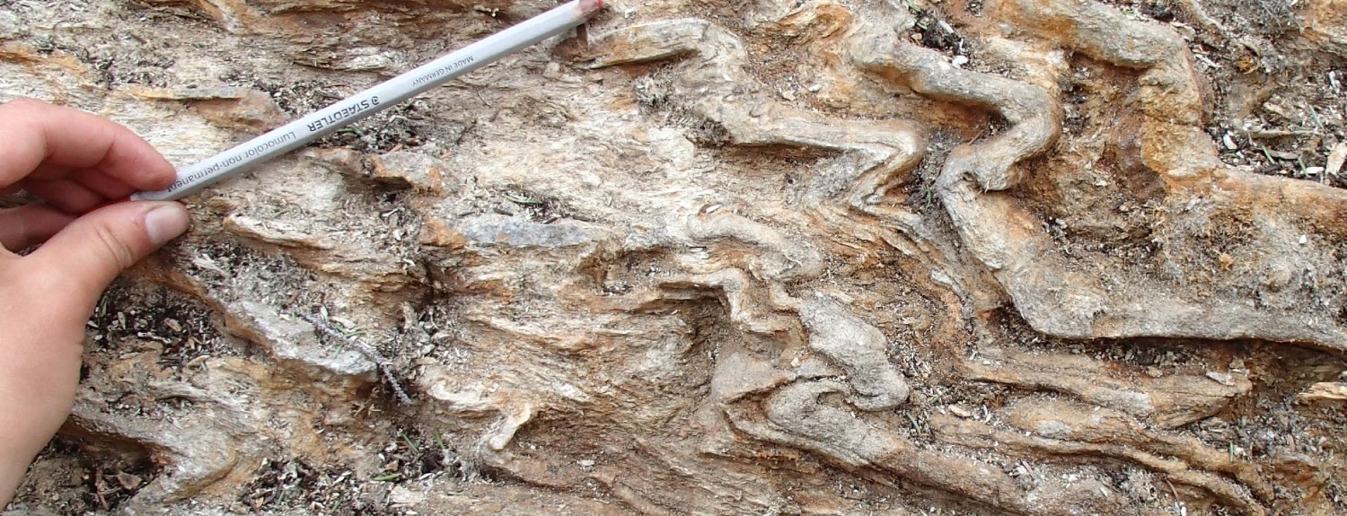
In the Dolent Structural Domain, magnetic field maps locally reveal geometries that could be the result of at least two folding phases, which can be confirmed by the folded trajectories of Sn foliation. Pn folds are folded by Pn+1 folds of axial plane subparallel to Sn+1 schistosity. At the outcrop scale, Pn+1 folds are chevron-shaped and commonly Z-shaped.
Geometric Parameters of Regional Folds:
| Fold or Family of Folds | Type (Anticline, Syncline or Undetermined) | Shape (Antiform or Synform) | Attitude (Overturned or Upright) | Axial Plane | Fold Axis | Position (Certain or Probable) | Deformation Phase | Comments | ||
| Direction | Dip | Direction | Plunge | |||||||
| Pn fold | Syncline and anticline | Antiform and synform | Upright and overturned | E-W to ENE-WSW | – | NE | – | Probable and certain | Dn | Open to isoclinal folds |
| Pn+1 fold | Undetermined | Unknown | Upright and overturned | NE-SW to NNE-SSW | – | – | – | Probable and certain | Dn+1 | Chevron, kink and Z folds |
| Western Branch Syncline | Syncline | Synform | Overturned | NE-SW | NW | NE to ENE | – | Certain | Dn | – |
| Eastern Branch Syncline | Syncline | Synform | Overturned | NE-SW | SE | – | – | Certain | Dn | – |
| Oriental Anticline | Anticline | Synform | Upright | NNE-SSW to NE-SW | – | – | – | Certain | Dn | – |
| Bohier Island Anticline | Anticline | Synform | Upright to slightly overturned | E-W | Strong towards the north | East | Moderate | Certain | Dn | – |
| Hécla Lake Anticline | Anticline | Synform | Overturned | NE-SW | SE | NE | Moderate | Certain | Dn | – |
❯ Crosscutting Relationships
Contacts between the sedimentary units of the Bohier Group and the various volcanic units in the UEGB are interpreted as being generally sheared. The contact between the western branch of the UEGB and the Digne Pluton is marked by the Digne Shear Zone.
In the eastern branch, there are several deformation zones following the general NE to ENE trend of the UEGB, including the Lake Harbour and Lake Banane shear zones.
The Lake Harbour Shear Zone, which is ∼50 m thick, was described by Francoeur and Chapdelaine (1995). It has an ENE orientation, a ∼55° dip to the SE and exhibits reverse dextral movement. Kinematic indicators (stretching lineations, phenocrysts, CS fabrics and boudinaged quartz veins) also indicate reverse movement with a dextral strike-slip component (Francoeur and Chapdelaine, 1995). The Lake Banane Shear Zone is parallel to the Lake Harbour Shear Zone located 700 m to the south. The attitude of this brittle-ductile deformation zone remains unknown, but its metallogenic importance is recognized.
The Tourigny Deformation Zone (Tourigny, 1989) developed during the main deformation phase in the southern branch. Frappier-Rivard (2015) describes two main faults, one at the wall of the deformation zone, the other at the roof. The wall fault, which overlies an ultramafic sill, is more developed than the roof fault. These faults are up to 10 cm thick and subparallel to the stratification. Kinematic indicators (C/S fabrics, asymmetric boudinage) are oriented NE-SW and generally imply reverse movement (Tourigny, 1989; Couture, 1993; Frappier-Rivard, 2015). However, a few drill core observations in 2010 and 2011 recorded both normal and reverse movement (Frappier-Rivard, 2015). The heterogeneities (mechanical and chemical) between the ultramafic rocks and their surrounding rocks could have fostered and circumscribed the development of the Tourigny Deformation Zone.
The Clément Formation, in the southern branch, is affected along its length by a series of NE-dipping reverse thrust faults, including the Bart Fault.
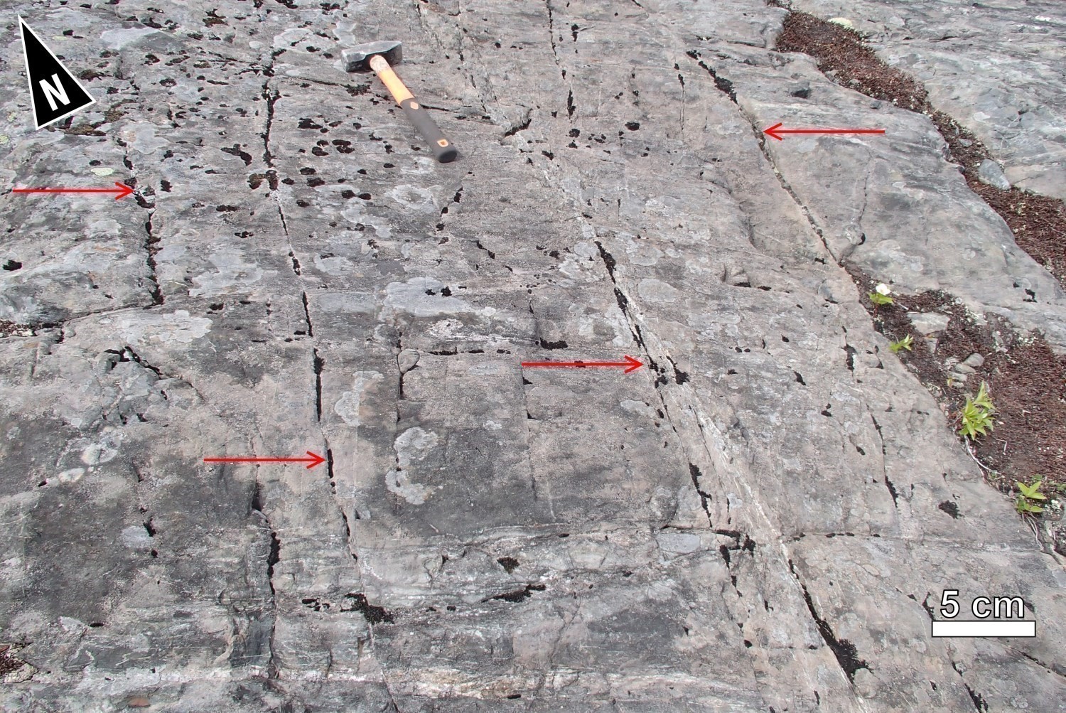 The existence of very detailed magnetic maps in the Dolent Structural Domain (Wade et al., 2014) has allowed mapping of numerous late fragile faults. These families of conjugated faults offset rocks in a dextral or sinistral manner. Field evidence corroborates the presence of faults and indicates that these fractures are characterized by steep dips. Families of diaclases and minor faults with displacements of a few centimetres to ~ 1 dm have been observed on several outcrops.
A family of ENE-WSW to E-W sinistral faults, including the René Fault (see Map of Structural Domains), displaces the units in the Bohier Island area and in the southern branch. Volcanic and sedimentary units show a shift on either side of Lake René; the iron formations (nAcln5), which constitute a marker level in the southern branch of the UEGB due to their high magnetic susceptibility, have been displaced over 250 m by a sinistral movement. The existence of highly detailed magnetic maps along the southern branch of the UEGB (St-Hilaire, 2013; Dubé, 2015) allowed the mapping of numerous fragile faults in this area. The sinistral kinematics of the majority of these faults are observed at the level of the mineralized zones in the Eastmain Mine sector, where a sinistral fault displaces and marks the boundary between Zones A and B of the deposit (Yassa, 2018; Beauchamp et al., 2018). Finally, a family of faults subsequent to the previous ones, oriented NW-SE, show dextral movements/displacements. These faults cut the Cadieux Pluton to the south of the western branch of the UEGB.
Geometric Parameters of Regional Faults Cutting the Dolent Structural Domain:
| Fault or Family of Faults | Type | Mean Direction (°) | Mean Dip (°) | Lineation Plunge in the Fault Plane | Estimated Width (m) | Estimated Length (km) | Apparent Movement | Position | Comments |
| Digne Shear Zone | Regional shearing | ENE-WSW | Unknown | Unknown | Unknown | 30 | Reverse | Certain | Western branch |
| Lake Harbour Shear Zone | Regional shearing | ENE-WSW | 55 towards the SE | Moderate towards the SE | 50 | 15 | Reverse dextral | Certain | Eastern branch |
| Lake Banane Shear Zone | Regional shearing | ENE-WSW | Unknown | Unknown | Unknown | 20 | Unknown | Certain | Eastern branch |
| Tourigny Deformation Zone | Regional shearing | NW-SE | Moderate towards the NE | Moderate towards the NE | 0.1 | 6 | Reverse | Certain | Southern branch, associated with the Eastmain Mine |
| Family of faults | Regional thrust fault | NW-SE to NNW-SSE | Moderate towards the NE | Unknown | Unknown | 8 to 30 | Reverse | Certain | Southern branch, comprising the Bart Fault |
| Family of faults | Regional shearing | E-W to WSW-ENE | Unknown | Unknown | Unknown | 4 to 25 | Sinistral | Certain | Southern branch, comprising the René Fault |
❯ Kinematics

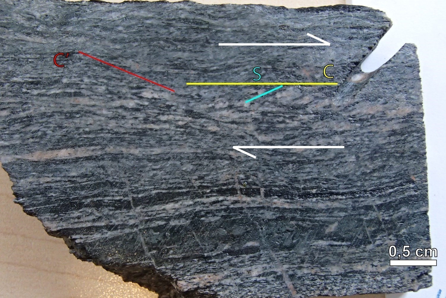 Flattening and stretching deformation is significant. Sigmoids, asymmetric Z-folds and centimetric to decimetric mylonitic levels within the conglomerate suggest reverse-dextral movement.
Deformation Style
In general, the Dolent Structural Domain displays evidence of very high deformation. This is characterized by significant transposition of primary and early structures in the main fabric.
The Dolent Structural Domain has a complex structural architecture. The first phase of Dn-1 deformation, associated with Sn-1 foliation, is globally oriented ENE-WSW. This deformation phase seems to have led to the development of domes exposing plutonic rocks, and of synclines preserving volcano-sedimentary sequences. In the Cadieux Lake area, exhumation of the Misasque Complex and Digne Pluton within a dome would then have led to early folding of the overlying Dolent Formation. Vertical movements during Dn-1 would also have been accommodated by shear zones located at the interface between the domes’ gneisso-plutonic packages and the synclines’ supracrustal units (e.g., the Digne Shear Zone).
Subsequently, during the Dn deformation phase, an episode of NNW-SSE shortening could have prolonged the subsidence of the supracrustal sequence in an ENE-WSW syncline, occupied by the Bohier Group. Along the edge of this basin, ENE-WSW shear zones appear to have contributed to the burial of supracrustal rocks. However, NNW-SSE shortening also resulted in the lateral creep of deeper crustal domains, such as the Misasque dome. This creep would have resulted, on the one hand, in the parallelization of Pn-1 fold axes and Ln mineral and stretching lineation in a NE plunging direction and, on the other hand, led to the overturning of the lithostratigraphic pile at the SW termination of the Misasque dome (see interpretative model of the Lac Cadieux Geological Bulletin; Beauchamp, 2020).
Finally, the Dn+1 deformation phase would have folded earlier fabrics, but could represent a late increment related to main Dn deformation episode.
Metamorphic Characteristics
The supracrustal rocks of the Dolent Structural Domain have reached the amphibolite facies. Mafic units nAdln1 and nAdln2 of the Dolent Formation are composed of a typical hornblende-plagioclase-epidote ± sphene assemblage. Actinolite and clinopyroxene are present locally and indicating that they have reached the lower and upper amphibolite facies, respectively. Mafic-ultramafic sills (nAdln3) are mainly composed of amphibole (± hornblende ± cummingtonite ± actinote), plagioclase and several retrograde minerals (epidote ± talc ± chlorite ± biotite). Finally, volcanic rocks and ultramafic sills (nAdln4) are characterized by prograde tremolite-magnetite ± olivine and retrograde serpentine-talc-chlorite assemblages.
Alterations
Does not apply.
Geophysical Characteristics
Maps of the vertical gradient of the total magnetic field from the Ministère and Wade et al. (2014) indicate that this domain is heterogeneous in terms of magnetic susceptibility. Rocks of the UEGB are characterized by a banded magnetic structure and weak to strong magnetic contrasts. Basalt of the Roman and Dolent Formation as well as conglomerate of the Bohier Group generally do not contain magnetite, and thus correspond to zones of low magnetic susceptibility. Topographic and magnetic lineaments in the western branch of this domain are clearly superimposed on Sn foliation trajectories.
The western branch of the UEGB is characterized by a shagreened pattern of low magnetic susceptibility, with thin strips characterized by positive magnetic anomalies that correspond to more or less continuous layers of ultramafic volcanic rocks and mafic-ultramafic sills from the Dolent Formation. These magnetic strips are sparse, straight and relatively continuous. To the south, they are cut by the Cadieux Suite rocks, which are characterized by very high magnetic susceptibility. At the western end of the western branch, curved lineaments indicate the closure of a synformal anticline Pn fold that folds the Sn-1 fabric. In the centre of the domain, the strong magnetic intensity of a Cadieux Suite pluton to the north and the Bohier Island Pluton in the Chiyaaskw Structural Domain contrasts sharply with the UEGB rocks. In the southern branch, the domain has well-defined continuous bands, with high density and an orientation that is parallel to the UEGB. To the east, the same phenomenon is observed, but the bands are regularly sectioned. In the centre of sheet 23D12, they are affected by the magnetic signature of silicate iron formation strips from the Roman Formation (nArmn4), giving them a more chaotic orientation.
Chronological Markers
A datation was obtained from a wacke paragneiss sample belonging to the Laguiche Complex (16-HH-1654-A, sheet 33A10). Monazite in this sample yielded a uniform age of 2692 ±6 Ma (Davis and Sutcliffe, 2018a), which represents the metamorphic age and the minimum age of deposition for sedimentary rocks. This age appears to date the main metamorphic episode associated with the Sedimentary Complex, and could therefore date the Dn deformation phase.
Since rocks in the MacLeod Batholith (2704 ±2 Ma, Davis, 2019) and Cadieux Suite (2700 ±3 to 2699 ±5 Ma, Davis, 2019; Davis and Sutcliffe, 2018b) are foliated by the Sn fabric, their emplacement either predates or is synchronous with Dn deformation. Their age of crystallization could date the beginning of the Dn deformation phase. The Dn deformation is earlier than 2640 Ma (Davis and Sutcliffe, 2018a), corresponding to the age of the Wahemen Suite, which is unaffected by deformation and metamorphism.
References
Publications Available Through Sigéom Examine
BEAUCHAMP, A.-M., MASSEI, F., DAOUDENE, Y., 2018. Géologie de la région de l’île Bohier, au contact entre les sous-provinces d’Opatica, d’Opinaca et le bassin d’Otish, au nord de Mistissini, Eeyou Istchee Baie-James, Québec, Canada. MERN; BG 2018-02, 2 plans.
BEAUCHAMP, A.-M., 2020. Géologie de la région du lac Cadieux, sous-provinces d’Opatica et d’Opinaca, Eeyou Istchee Baie-James, Québec, Canada. MERN; BG 2019-02, 2 plans.
BENAHMED, S., INTISSAR, R., 2016. LEVÉ MAGNÉTIQUE AÉROPORTÉ DANS LE SECTEUR DES MONTS OTISH. MERN, EON GEOSCIENCES INC; DP 2016-04, 7 pages, 2 plans.
CHARTIER-MONTREUIL, W., TALLA TAKAM, F., BEAUCHAMP, A.-M., MASSEI, F., 2025. Géologie de la région du lac Léran, sous-provinces d’Opatica, d’Opinaca et de la Grande, Eeyou Istchee Baie-James, Québec, Canada. MRNF; BG 2016-01, 1 plan
CLEVEN, N. R., HARRIS, L. B., GUILMETTE, C., 2020. Structural interpretation of enhanced high-resolution aeromagnetic depth slices of the Eeyou Istchee Baie-James region, Québec Superior province. UNIVERSITÉ LAVAL, INRS, MERN; MB 2020-02, 84 pages.
COUTURE, J.-F., 1993. Géologie et gîtologie du gisement de la rivière Eastmain. UQAC. TH 1745, 277 pages.
D’AMOURS, I., 2011. Synthèse des levés magnétiques de la Baie-James. MRNF; DP 2011-08, 5 pages, 2 plans.
DAVIS, D.W., 2019. Rapport sur les datations U-Pb de roches du Québec 2018-2019, projets Lac Cadieux et Lac Watts. UNIVERSITY OF TORONTO; MB 2019-09, 82 pages.
DAVIS, D.W., SUTCLIFFE, C.N., 2018a. U-Pb Geochronology of Zircon and Monazite by LA-ICPMS in samples from northern Quebec. UNIVERSITY OF TORONTO; MB 2018-18, 54 pages.
DAVIS, D.W., SUTCLIFFE, C.N., 2018b. U-Pb Geochronology of Zircon and Monazite by LA-ICPMS in Samples from Northern Quebec. UNIVERSITY OF TORONTO. MB 2019-01, 113 pages.
FRANCOEUR, G., CHAPDELAINE, M., 1995. Rapport des travaux 1994, projet rivière Eastmain (40349). Ministère des Ressources naturelles, Québec; GM 53057, 48 pages and 7 plans.
FRAPPIER-RIVARD, D., 2015. TECHNICAL REPORT AND RECOMMENDATIONS, SUMMER 2013-2014 EXPLORATION PROGRAM, EASTMAIN MINE PROJECT. EASTMAIN MINES INC, Assessment work submitted to the Government of Québec; GM 69062, 1293 pages, 3 plans.
ST-HILAIRE, C., 2013. HELIBORNE HIGH RESOLUTION AEROMAGNETIC SURVEY, EASTMAIN MINE AND RUBY HILL EAST PROPERTIES. EASTMAIN RESOURCES INC, EASTMAIN MINES, C, Assessment work submitted to the Government of Québec; GM 69075, 26 pages, 6 plans.
TALLA TAKAM, F., BEAUCHAMP, A.-M., 2016. Géologie-Lac Léran. MERN; CG-2016-08, 1 plan.
WADE, T., COCIORBA, T., LEGAULT, J., PLASTOW, G., 2014. REPORT ON 3-AXIS HELICOPTER-BORNE MAGNETIC GRADIOMETER GEOPHYSICAL SURVEY, RUBY HILL WEST BLOCK. EASTMAIN RESOURCES INC. Assessment work submitted to the Government of Québec; GM 68338, 40 pages and 36 plans.
Other Publications
DUBÉ, B., GOSSELIN, P., MERCIER-LANGEVIN, P., HANNINGTON, M., GALLEY, A., 2007. Gold-rich volcanogenic massive sulphide deposits, In: Goodfellow W.D., ed., Mineral Deposits of Canada: A synthesis of Major Deposit-Types, District Metallogeny, the Evolution in Geological Provinces, and Exploration Methods: Geological Association of Canada, Mineral Deposits Division, Special Publication 5, pages 75-94.
TOURIGNY, G., 1989. Reconnaissance structural analysis of the Eastmain River gold deposit, Mistassini Territory, Quebec. Rapport préparé pour Placer-Dome Inc. et Resources MSV Itée. IREM-MERI, Montréal.
YASSA, A., 2018. NI 43-101 Technical report and initial mineral resource estimate on the Eastmain Mine Property James Bay District, Quebec for Eastmain Resources Inc.
Suggested Citation
Contributors
|
First publication |
Anne-Marie Beauchamp, P. Geo., M.Sc. anne-marie.beauchamp@mern.gouv.qc.ca (redaction) Ghyslain Roy, P. Geo. (coordination); Patrice Roy, P. Geo., Ph.D. (critical review); Simon Auclair, P. Geo., M.Sc. (editing); Ricardo Escobar (HTML editing); Céline Dupuis, P. Geo., Ph.D. (English version) |
|
Revision |
William Chartier-Montreuil, P. Geo. william.chartier-montreuil@mrnf.gouv.qc.ca (redaction) Hanafi Hammouche, P. Geo., M.Sc. (coordination); Daniel Bandyayera, P. Geo., Ph.D. (critical review); Simon Auclair, P. Geo., M.Sc. (editing); André Tremblay (HTML editing); Catherine Tremblay (English version) |