

Last modification:
Background
Several names have been used to refer to the Rachel-Laporte lithotectonic domain. The term “Rachel Zone” has been used in the northern part (Wares and Goutier, 1989, 1990; Wardle et al.., 1990; Bardoux, 1998; Hall et al., 2002), and the terms “Laporte Terrane” (Wardle et al., 1990; Kerr et al., 1994; Hall et al., 2002) and “Laporte Domain” (Van der Leeden et al., 1990) have been used in the southern part. Wardle and Van Kranendonk (1996) and Wardle et al. (2002) used the term Rachel-Laporte Zone to refer to the area comprising the northern and southern parts. This term has subsequently been used by the whole scientific community.
This area was renamed the Rachel-Laporte Lithotectonic Domain as part of a synthesis of the Southeastern Churchill Province (SECP; Lafrance et al., 2018). Boundaries were redefined by Lafrance and Vanier (2021) following a 1:250 000 scale mapping campaign carried out by the Ministère between 2011 and 2017.
Description
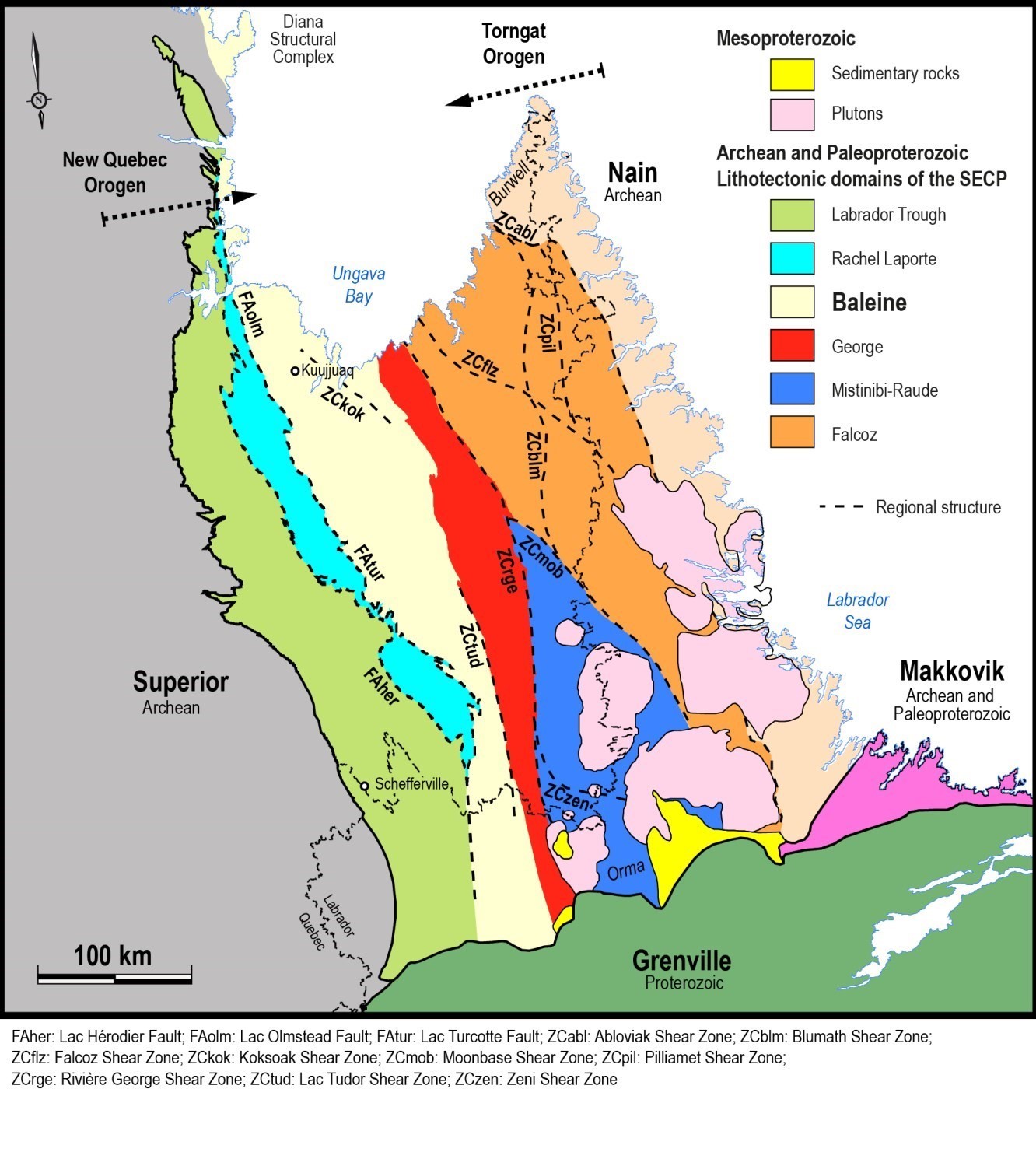 The Rachel-Laporte lithotectonic domain is located in the western part of the SECP. It is nearly 600 km long and 30 km to 40 km wide, with a total area of 13 674 km2. Its width is considerably reduced (2-15 km) at its northern and southern ends and in the Wheeler Complex area. The Rachel-Laporte Domain is generally NNW-SSE trending and is bounded to the east by the Baleine Lithotectonic Domain, with which it is in fault contact via a system of large relay thrust faults. These are represented, from north to south, by the Lac Olmstead and Lac Turcotte faults. To the west, the contact style is similar to the Labrador Trough and is formed by the Pointe-Reef, Lac Hérodier and Lac Keato faults. At its southern end, the Rachel-Laporte Domain pinches off at the Gill Lake Fault, which then directly brings the rocks of the Labrador Trough into contact with those of the Baleine Lithotectonic Domain.
Geology
The Rachel-Laporte Lithotectonic Domain is dominated by the Laporte Supersuite, which consists mainly of Paleoproterozoic metasedimentary rocks of the Freneuse Suite (1834-1804 Ma; Henrique-Pinto et al., 2017; Godet et al., 2020) and, to a lesser extent, mafic and ultramafic intrusive and effusive rocks of the Klein Suite. These rocks were metamorphosed to the amphibolite facies and were generally unaffected by significant partial melting that characterizes units of the Baleine Lithotectonic Domain directly to the east (Lafrance and Vanier, 2021). However, evidence of partial melting has been observed locally at the eastern edge of the Rachel-Laporte Domain (Lafrance and Vanier, 2021).
The Rachel-Laporte Domain also includes six structural complexes consisting of Archean or Paleoproterozoic rocks that are contained within tectonic slices that overthrusted Paleoproterozoic rocks during the New Quebec Orogenesis. These units are, from north to south: the Boulder Complex (2868 Ma), the Rénia Complex (2883-2692 Ma), the Highfall Complex (2705 Ma), the Boullé Complex (2690 Ma), the Horseshoe Complex and the Giton Complex (1829 Ma).
The different units of the domain are also locally intruded by felsic and commonly pegmatitic dykes or sills of the Mercier Suite.
| MESOPROTEROZOIC | ||
| mPsip | Slippery Dykes | Subophitic olivine gabbro |
| mPfal | Falcoz Swarm | Subphitic and massive olivine gabbro and olivine gabbronorite |
| PALEOPROTEROZOIC | ||
| pPmer | Mercier Suite | Massive pegmatite and granite |
| pPhib | Hibou Stock | Felsic intrusive rocks |
| pPavn | Giton Complex | Diatexite and migmatized paragneiss |
| Laporte Supersuite | ||
| pPprv | Préville Suite | Deformed and metamorphosed calcosilicate rocks |
| pPkle | Klein Suite | Amphibolite; mafic and ultramafic intrusive rocks |
| pPfru | Freneuse Suite | Metawacke, meta-arenite, paragneiss and paraschist |
| pPsec | Secondon Suite | Metamorphosed arkose, conglomeratic arenite and conglomerate |
| ARCHEAN AND PALEOPROTEROZOIC | ||
| ApPhrs | Horseshoe Complex | Speckled and foliated monzonite, quartz monzonite and monzodiorite |
| ARCHEAN | ||
| nAbue | Boullé Complex | Porphraceous and foliated monzonite, monzodiorite and quartz monzodiorite |
| Area | Rénia Complex | Granitic gneiss |
| nAhig | Highfall Complex | Porphraceous and foliated monzogranite and quartz monzonite |
| Ablr | Boulder Complex | Tonalitic gneiss |
Geological Evolution
Several authors have proposed that volcano-sedimentary rocks of the Laporte Supersuite are mostly more strongly metamorphosed equivalents of rocks of the Kaniapiscau Supergroup in the Labrador Trough (Harrison, 1952; Gélinas, 1958a, b; Sauvé and Bergeron, 1965; Simard et al., 2013).
However, significant differences between detrital zircon populations of these two lithotectonic domains indicate different sources (Henrique-Pinto et al., 2017; Godet et al., 2020), confirming the hypothesis of Charette et al. (2016) who questioned this equivalence based on the apparent thickness and composition of metasedimentary rocks of both domains. The age distribution of detrital zircons from the Freneuse Suite ranges from 3226 Ma to 1830 Ma (Herrique-Pinto et al., 2017; Godet et al., 2020). There are Paleoproterozoic and Archean population peaks that are interpreted to indicate provenance from different lithotectonic domains of the SECP, namely the George, Baleine and Mistinibi-Raude domains (Henrique-Pinto et al., 2017; 2019). The source of Kaniapiscau Supergroup sediments is thought to be the Superior Province, as all detrital zircons are Archean in age (Henrique-Pinto et al., 2017; 2019).
The work of Henrique-Pinto et al. (2017, 2019) also suggests different settings between the Laporte Supersuite (Rachel-Laporte Domain) and the Kaniapiscau Supergroup (Labrador Trough). The latter would have been deposited along an intraplate continental margin characterized by a predominance of Archean recycled sources. In the case of the Laporte Supersuite, analysis of the age distribution of detrital zircons indicates an evolution of the depositional environment through time, i.e. a first cycle corresponding to the deposition of conglomerate and arkose in a continental forearc basin setting, followed by a second cycle of feldspathic wacke deposition within a foreland basin (Henrique-Pinto et al., 2017; 2019).
Supracrustal rocks of the Rachel-Laporte Domain overthrusted those of the Labrador Trough during the New Quebec Orogenesis (1.82-1.77 Ga; Wardle et al., 2002). Based on petrochronology and metamorphic modelling, Godet et al.. (2020) propose that the Baleine Domain overthrusted the Rachel-Laporte Domain along the Lac Turcotte Fault, between 1830 Ma and 1800 Ma, causing burial and amphibolite facies metamorphism of the latter at ~1793 Ma (Machado et al., 1989).
As for tectonic scales of Archean crust or Paleoproterozoic rocks, they were emplaced by thick-skin tectonics associated with westward thrusting (Charette et al., 2016; Lafrance and Vanier, 2021). They were brought into a higher structural position than metasedimentary rocks through thrust faults (Boulder, Rénia, Highfall, Boullé and Giton complexes) or folding (Horseshoe Complex).
References
Publications Available Trough SIGÉOM Examine
CHARETTE, B., LAFRANCE, I., MATHIEU, G., 2016. Géologie de la région du lac Jeannin, Québec, Canada. MERN; BG 2015-01, 1 plan.
GELINAS, L., 1958. RAPPORT PRELIMINAIRE SUR LA REGION DU LAC GABRIEL (PARTIE OUEST), NOUVEAU-QUEBEC. MRN; RP 373, 13 pages, 1 plan.
GELINAS, L., 1958. RAPPORT PRELIMINAIRE SUR LA REGION DU LAC THEVENET (MOITIE EST), NOUVEAU-QUEBEC. MRN; RP 363, 11 pages, 1 plan.
LAFRANCE, I., CHARETTE, B., VANIER, M-A., 2018. Sud-est de la Province de Churchill, Nunavik, Québec, Canada: synthèse de la géologie. MERN; BG 2018-12
LAFRANCE, I., VANIER, M.-A., 2021. Domaine lithotectonique de Rachel-Laporte, sud-est de la Province de Churchill, Québec, Canada : synthèse de la géologie. Ministère de l’Énergie et des Ressources naturelles. BG 2021-01
N A C S N, 1986. CODE STRATIGRAPHIQUE NORD-AMERICAIN. DV 86-02, 76 pages.
SAUVE, P., BERGERON, R., 1965. REGION DES LACS GERIDO ET THEVENET, NOUVEAU-QUEBEC. MRN; RG 104, 141 pages, 3 plans.
SAUVE, P., BERGERON, R., 1965. GERIDO LAKE – THEVENET LAKE AREA, NEW QUEBEC. MRN; RG 104(A), 131 pages, 3 plans.
SIMARD, M., LAFRANCE, I., HAMMOUCHE, H., LEGOUIX, C., 2013. GEOLOGIE DE LA REGION DE KUUJJUAQ ET DE LA BAIE D’UNGAVA (SNRC 24J, 24K). MRN; RG 2013-04, 62 pages, 1 plan.
WARES, R., GOUTIER, J., 1989. METALLOGENIE DES INDICES DE SULFURES AU NORD DU 57e PARALLELE (ETAPE II) – FOSSE DU LABRADOR. MRN; MB 89-38, 122 pages, 1 plan.
WARES, R., GOUTIER, J., 1990. SYNTHESE METALLOGENIQUE DES INDICES DE SULFURES AU NORD DU 57e PARALLELE – FOSSE DU LABRADOR – RAPPORT INTERIMAIRE – ETAPE III. IREM-MERI; MB 90-25, 104 pages, 2 plans.
Other Publications
BARDOUX, M., DIGONNET, S., DONOHUE, L., GIRAD, B., ROBILLARD, M., DAVID, J., PARENT, M., GARIÉPY, C., 1998. Paleoproterozoic tectonics affecting Archean lower crust of southern Ungava Bay. In: Eastern Canadian Shield Onshore–Offshore Transect (ECSOOT), Report of the 1998 Transect Meeting. Compiled by RJ Wardle and J. Hall. The University of British Columbia, Lithoprobe Secretariat, Report, voulum 68, pages 1-17.
EASTON, R.M., 2009. A guide to the application of lithostratigraphic terminology in Precambrian terrains. Stratigraphy; , 2009, volume 6, no 2, pages 117-134.
GODET, A., GUILMETTE, C., LABROUSSE, L., DAVIS, D.W., VANIER, M.-A., LAFRANCE, I., CHARETTE, B., 2020. Contrasting P-T-t paths reveal a metamorphic discontinuity in the New Quebec Orogen: insights into Paleoproterozoic orogenic processes. Precambrian Research; article 105675. doi.org/10.1016/j.precamres.2020.105675
HARRISON, J.M., 1952. The Quebec-Labrador iron belt, Quebec and Newfoundland. Geological Survey of Canada; Paper 52-20, 21 pages. dx.doi.org/10.4095/123923
HALL, J., LOUDEN, K.E., FUNCK, T., DEEMER, S., 2002. Geophysical characteristics of the continental crust along the Lithoprobe ECSOOT transect: a review. Canadian Journal of Earth Sciences; Volume 39, pages 569-587. dx.doi.org/10.1139/e02-005
HENRIQUE-PINTO, R., GUILMETTE, C.,BILODEAU, C., McNICOLL, V., 2017. Evidence for transition from a continental forearc to a collisional pro-foreland basin in the eastern Trans-Hudson Orogen: Detrital zircon provenance analysis in the Labrador Trough, Canada. Precambrian Research; volume 296, pages 181-194. doi.org/10.1016/j.precamres.2017.04.035
HENRIQUE-PINTO, R., GUILMETTE, C., BILODEAU, C., STEVENSON, R., CARVALHO, B.B., 2019. Petrography, geochemistry, and Nd isotope systematics of metaconglomerates and matrix-rich metasedimentary rocks: implications for the provenance and tectonic setting of the Labrador Trough, Canada. Canadian Journal of Earth Sciences, volume 56, pages 672-687. doi.org/10.1139/cjes-2018-0187
KERR, A., JAMES, D.T., FRYER, B.J., 1994. Nd isotopic geochemical studies in the Labrador shield: a progress report ans preliminary data from the Churchill (Rae) Province. Geological Survey of Newfoundland and Labrador, Department of Natural Resources, pages 51-61.
MACHADO, N., GOULET, N., GARIÉPY, C., 1989. U-Pb geochronology of reactivated Archean basement and of Hudsonian metamorphism in the northern Labrador Trough. Canadian Journal of Earth Sciences; volume 26, pages 1-15. doi.org/10.1139/e89-001
NACSN, 2005. North American Stratigraphic Code. The American Association of Petroleum Geologist Bulletin; volume 89, pages 1547-1591. doi.org/10.1306/07050504129
VAN DER LEEDEN, J., BÉLANGER, M., DANIS, D., GIRARD, R., MARTELAIN, J., 1990. Lithotectonic domains in the high-grade terrain east of the Labrador Trough (Quebec). In: The Early Proterozoic Trans-Hudson Orogen (Lewry, J.F., Stauffer, M.R., editors). Geological Association of Canada; Special Paper 37, pages 371-386.
WARDLE, R.J., VAN KRANENDONK, M.J., 1996. The Paleoproterozoic Southeastern Churchill Province of Labrador-Quebec, Canada: orogenic development as a consequence of oblique collision and indentation. In: Precambrian Crustal Evolution in the North Atlantic Region (Brewer, T.S., editor). Geological Society; Special Publication, volume 112, pages 137-154. doi.org/10.1144/GSL.SP.1996.112.01.08
WARDLE, R.J., JAMES, D.T., SCOTT, D.J., HALL, J., 2002. The southeastern Churchill Province: synthesis of a Paleoproterozoic transpressional orogen. Canadian Journal of Earth Science; volume 39, pages 639-663. doi.org/10.1139/e02-004
WARDLE, R.J., RYAN, B., ERMANOVICS, I., 1990. The eastern Churchill Province, Torngat and New Québec orogens: An overview. Geoscience Canada; volume 17, pages 217-222.
Suggested Citation
Ministère de l’Énergie et des Ressources naturelles (MERN). Rachel-Laporte Lithotectonic Domain. Quebec Stratigraphic Lexicon. https://gq.mines.gouv.qc.ca/lexique-stratigraphique/province-du-superieur/zone-de-rachel-laporte_en [accessed on Day Month Year].
Contributors
|
First publication |
Isabelle Lafrance, P. Geo., M.Sc. isabelle.lafrance@mern.gouv.qc.ca; Marc-Antoine Vanier, Jr. Eng., M.Sc. marc-antoine.vanier@mern.gouv.qc.ca (redaction) Mehdi A. Guemache, P. Geo., Ph.D. (coordination); Carl Bilodeau, P. Geo., M.Sc. (critical review); Simon Auclair, P. Geo., M.Sc. (editing); Céline Dupuis, P. Geo., Ph.D. (English version); André Tremblay (HTML editing). |