


Geology of the Champion Lake Region, La Grande and Nemiscau Subprovinces, East of Waskaganish, Eeyou Istchee James Bay, Quebec, Canada
Project for NTS sheets 32N08 and 32N09
Daniel Bandyayera and Yannick Daoudene
BG 2018-06
Translated on 20 November 2018


Prospective zones for Ni-Cu±Cr±Co±PGE mineralization south of Caumont Lake, southeast of Champion Lake and south of Valiquette Lake
Mafic to ultramafic intrusions (gabbro, pyroxenite and peridotite), which are generally highly magnetic, have been recognized within the Lac des Montagnes Group’s volcano-sedimentary sequence…

The Lac des Montagnes Group, a prospective zone for polymetallic deposits
The Lac des Montagnes Group is composed of volcanic and sedimentary rocks metamorphosed to the amphibolite facies. These rocks contain disseminated sulphides in places or in the form of laminae or platings in fractures…

Prospective zone for Zn-Ag±Pb±Au mineralization associated with stratiform exhalative sulphide horizons south of Indien Lake
Paragneiss of the Rupert Complex south of Indien Lake, generally weakly or not migmatitized, contain stratiform horizons prospective for Zn-Ag (±Pb±Au) mineralization…
A new 1:50,000-scale geological map of the Champion Lake region (NTS sheets 32N08 and 32N09) was produced following a survey conducted in summer 2017. At the centre of the mapped area is a kilometric belt of volcano-sedimentary rocks Lac des Montagnes Group), which represents the junction between the subprovinces of La Grande in the north and Nemiscau and Opatica in the south. The belt’s contacts with the Archean subprovinces are prime metallotects, just as the Opinaca-La Grande contact is recognized further north.
Mapping of this area delineated volcano-sedimentary units of the Lac des Montagnes Group. Mafic and ultramafic sills, bearing Ni-Cu (±Cr±Co±PGE) mineralization, have been mapped and assigned to the Caumont Mafic-Ultramafic Suite. Our work has also helped to better define the context for stratiform exhalative polymetallic mineralization hosted in paragneiss of the Rupert Complex and in volcano-sedimentary rocks of the Lac des Montagnes Group.
Methodology
The region was mapped using the established method for surveys in isolated areas with some road access.
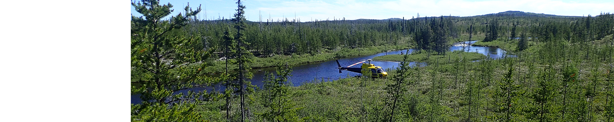
This area has been systematically covered by spaced pathways of approximately 1 km in volcano-sedimentary rocks and 2.5 to 5 km in intrusive rocks, as well as by helicopter (“leapfrog technique”) in areas with more repetitive geology. Fieldwork was completed by a team of six geologists and six students between June 15 and August 15, 2017.
The mapping of the study area produced and updated the information presented in the table below.
| Elements | Number |
|---|---|
| Outcrops described (“geofiches”) | 1021 |
| Total lithogeochemical analyses | 262 |
| Lithogeochemical analyses of metals of economic interest | 89 |
| Geochronological analyses | 5 |
| Covered thin sections | 325 |
| Polished thin sections | 8 |
| Sodium cobaltinitrite stains | 147 |
| Stratigraphic units | 14 |
| Mineralization records | 9 |
Previous Work
The table below provides a list of the work done in the study area since 1962.
| Author(s) | Type of Work | Contribution | Link(s) |
|---|---|---|---|
| Mapping of various areas in the Champion Lake region | Initial geological coverage of the study area; identifying the first sectors of interest for mineral exploration for polymetallic and industrial minerals mineralization. |
||
| Regional geological syntheses | Definition of boundaries of the La Grande, Nemiscau and Opatica subprovinces; identification of regional structural fabrics. | ||
|
Lalancette and Lévesque Michaud, |
Detailed mapping and mining exploration | Early mineral exploration drilling in the region. Several showings of nickel, copper, zinc, silver, gold and platinum group elements were discovered in prospective zones of Caumont Lake, Southeast Champion Lake, Southwest Valiquette Lake, Indien Lake and Lake des Montagnes. | |
| D'Amours, 2011a, 2011b | Aeromagnetic surveys | Complete coverage of the region by high-resolution aeromagnetic surveys. | |
| Beaumier and Kirouac, 1996 | Lake bottom sediment surveys by the Ministère | Multi-element geochemical anomaly maps. | MB 96-22 |
Lithostratigraphy
The Champion Lake region is located west of Nemiscau Lake, straddling three Archean subprovinces of the Superior : the Nemiscau, La Grande and Opatica subprovinces (Card and Ciesielski, 1986; Sawyer and Benn, 1993; Hocq et al., 1994; Benn, 2006; Percival et al., 2012).
This region is primarily composed of intrusive and metasedimentary rocks. Volcanic rocks are present in small proportions. In the southern half of the study area, the Nemiscau Subprovince is dominated by metasedimentary rocks migmatized to varying degrees and assigned to the Rupert Complex. The northern portion is occupied by intrusive rocks assigned to the Champion Complex, which represents the southwest extension of the La Grande Subprovince. In contact with the Champion Complex, the Nemiscau Subprovince contains a volcano-sedimentary belt assigned to the Lac des Montagnes Group.
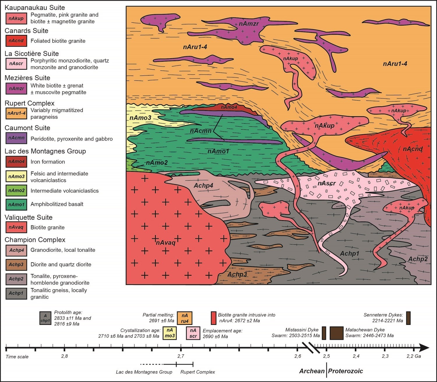
Rocks of the various lithostratigraphic and lithodemic units in the region are described in the following paragraphs according to their age and the subprovince to which they belong. The simplified stratigraphic diagram shows the relationships between the different lithostratigraphic units in the study area, to help the reader better understand their spatial and chronological arrangements. It is accompanied by a chronological timeline that lists the ages of certain units, estimated from U-Pb datings and crosscutting relationships observed in the field.
LA GRANDE SUBPROVINCE
The Champion Complex (Bandyayera and Daoudene, 2018) consists mainly of units forming a large multi-phase intrusive mass of the Lac Champion Plutonic Terrain (Hocq et al., 1994), assigned by Card and Ciesielski (1986) to the La Grande Subprovince. It is bounded to the north by the Eastmain Group, to the west and south by the Nemiscau metasedimentary Subprovince, and to the east by the Opinaca Subprovince. In the mapped region, the Champion Complex includes five units consisting of 1) tonalitic gneiss, locally granitic (Achp1); 2) pyroxene and hornblende tonalite and granodiorite (Achp2); 3) quartz diorite and diorite (Achp3); 4) granodiorite, locally tonalitic (Achp4); and 5) porphyritic granodiorite (Achp5).
Units Achp1 and Achp2 have been defined in the La Grande Subprovince (Bandyayera and Daoudene, 2018). These units have also been recognized in the heart of the Nemiscau Subprovince, where they occur in the form of exhumed ancient domes, dated between 2816 ±9 Ma and 2833 ±11 Ma (Jean David, personal communication, 2018), and of kilometric dimensions (Bandyayera and Daoudene, 2018). These Mesoarchean rocks are therefore present in both the subprovinces of La Grande, Nemiscau and probably Opatica (Davis et al., 1995). The gneissic texture is primarily marked by alternating millimetric to centimetric bands, tonalitic, dioritic and granitic. This banding is locally accentuated by centimetric intrusions of pink granite or granodiorite, parallel to foliation planes. Rocks assigned to unit Achp2 usually outcrop with tonalitic gneiss of unit Achp1. They are characterized by the local presence of pyroxene and the ubiquitous presence of hornblende. Unit Achp3, which is very limited in size, is composed of rocks of intermediate composition. In the Champion Lake area, it is observed in the NE corner of sheet 32N09 and north of sheet 32N08. Unit Achp4 is located south of the Champion Lake area, north of the Rivière Rupert Shear Zone (RRSZ). It is made up of an assemblage of tonalite and foliated granodiorite, which is difficult to distinguish in outcrop. The rock is granoblastic, greyish in fresh exposure and grey-beige in altered surface. Unit Achp5 was defined in the Lake Boisrobert area (sheet 32N011), where it is located in the heart of the Lac de Champion Plutonic Terrain. In the Champion Lake area, unit Achp5 is of limited extension and is located in the NE corner of sheet 32N09. It is made up of homogeneous, massive to foliated granodiorite, which is distinguished by its porphyraceous texture with K-feldspar phenocrystals of 1 to 2 cm, euhedral, locally subrounded. Outcrops assigned to unit Achp5 contain locally up to 30% granite in diffuse or transitional intrusive contact with granodiorite.
The Anatacau-Pivert Formation is represented by klippes of metabasalt and amphibolite (unit nAnp1) and metagrauwackes (unit nAnp7), in enclave in the granodiorite of the Champion Complex or in the Valiquette Pluton. The metabasalt is fine grained, dark grey-green in altered surface, and greyish green in fresh exposure, of tholeitic to transitional affinity. Metgrawackes are typically paragneiss rich in biotite (30%) and garnet (20%), locally weakly migmatized.
The Valiquette Pluton (nAvaq) is made of biotite granite, which is generally massive and very homogeneous. It covers the northern half of sheet 32N09. In places, it contains metric enclaves of gneissic tonalite, amphibolite, diorite and porphyritic granodiorite. Chemically, biotite granite is type I, peraluminous, alkaline-calcic to shoshonitic, potassium-rich (K2O >4 wt.%) and characterized by negative Eu anomalies. This granite is distinguished from other granitic rocks in the region by its high Rb contents. Its geochemical signature clearly places it among syncollisional granites (Pearce et al., 1984).
NEMISCAU SUBPROVINCE
In the mapped area, the Nemiscau is represented by a volcano-metasedimentary group cut by multiple multi-phase intrusions of felsic to ultramafic composition.
The Lac des Montagnes Group was introduced to describe all volcano-sedimentary rocks located south of the RRSZ, between the Champion Complex in the north and migmatitized paragneiss of the Nemiscau Subprovince in the south. In the Champion Lake region, the Lac des Montagnes Group includes four units. Unit nAmo1 is made up of variably metamorphosed basalt, which occur as massive to pillow flows and flow breccias. Lithogeochemical analyses show that this is a sequence of tholeiitic basalts and andesitic basalts of transitional affinity. Most tholeiitic basalts display rare earth diagrams and trace element ratios typical of those of N-MORB (Pearce, 2008; Wood, 1980). Unit nAmo2 is made up of intermediate volcanics, generally described as amphibolites after basalts in outcrop. Their classification is essentially based on the results of lithogeochemical analyses. These rocks are meta-andesites of calc-alkaline affinity. UnitnAmo3 is composed of felsic volcanoclastics, interstratified with metabasalts of the nAmo1 unit. The best preserved lithologies are lapilli and ash tuffs. Lithogeochemical analyses show that the nAmo3 tuffs are of rhyodacitic composition, calc-alkaline affinity, significantly enriched in light rare earth elements. Two U-Pb datings on zircons gave intrusion ages of 2710 ±6 Ma and 2703 ±8 Ma and inherited zircons at 2755 Ma and 2810 Ma (Jean David, personal communication, 2018). Unit nAmo4 consists of iron formation horizons observed at the top of amphibolitized basalts. Iron formations are usually at the oxide facies and, locally, at the silicate facies.
The Rupert Complex includes all variably migmatitized metasedimentary rocks of the Nemiscau Subprovince (Bandyayera and Daoudene, 2017). It stratigraphically overlies the Lac des Montagnes Group. Five units were defined in the works of Remick (1963), Valiquette (1975) and Gillain (1965). Unit nAru1 is composed of biotite-hornblende-garnet ± sillimanite ± cordierite paragneiss containing less than 10% mobilisate. It is generally located near the metamorphosed volcanic sequence of the Lac des Montagnes Group. Primary structures of the paragneiss are locally preserved. Aluminosilicates (sillimanite and cordierite) are abundant in the southeast of sheet 32N09. They are generally concentrated in specific horizons, probably more pelitic, in the form of millimetric to centimetric porphyroblasts. Unit nAru2 consists of migmatitized paragneiss containing 10-20% mobilisate. This unit is not widespread in the study area. The largest horizons are interstratified with unit Aru1, but are also found in the middle of diatexites (unit nAru4). Unit nAru3 consists of metatexite after paragneiss containing 20 to 50% mobilisate. It is well exposed to the south of the region, at the contact or in the middle of diatexites (unit nAru4). Nebulitic and stromatic textures are widespread in this migmatite. Some metatexite outcrops show horizons of paragneiss where primary textures are locally preserved. Unit nAru4 includes all migmatites after paragneiss containing 50 to 90% mobilisate and interpreted as diatexites. It covers almost the southern half of sheet 32N08. The rock is typically heterogeneous, with nebulitic, stromatic, and locally porphyraceous textures. Diatexite is also characterized by the presence of numerous biotite schlierens. Orthopyroxene and garnet are present in places in the form of poikilitic crystals. Chemically, all diatexites in unit nAru4 are peraluminous, type S, and enriched with potassium. A U-Pb dating on a porphyraceous diatexite sample (outcrop 2017-DB-1050) gave a crystallization age of 2691 ±5.9 Ma (Jean David, personal communication, 2018), while a granite cutting the diatexite, located 90 km WSW in the study area, was dated to 2672 Ma (Davis et al., 1995).
The Caumont Mafic-Ultramafic Suite (nAcmn) consists of mafic and ultramafic sills (peridotite, pyroxenite and gabbro) observed in the volcano-sedimentary sequence of the Lac des Montagnes Group. Some sills have, in some places, thin horizons of peridotite containing serpentine acicular rods, interpreted as olivine spinifex relics in a komatiitic lava. The extent of these komatiitic lavas could not be determined. The normative composition of peridotite is harzburgite, that of pyroxenite is olivine websterite, and that of mafic rocks is norite and gabbronorite. Ultramafic rocks are of komatiitic to tholeiitic affinity, while mafic rocks are tholeiitic.
The Mezières Suite (nAmzr) is composed of white to beige-pink granitic pegmatite, usually associated with the Rupert Group’s migmatitic rocks. It usually contains metric to decametric paragneiss enclaves, which are usually boudinaged and resemble in places partially digested restites. The rock typically contains biotite (up to 10%), muscovite (up to 5%), garnet (1-5%) and magnetite grains, disseminated or in centimetric clusters. The Mezières Suite is interpreted as being the most evolved rocks from partial melting of metasediments of the Rupert Complex. From a geochemical perspective, they are peraluminous and type S.
UNITS BELONGING TO MULTIPLE SUBPROVINCES
The La Sicotière Suite is a new lithodeme introduced to describe a package of typically foliated porphyritic plutonic rocks that intrude the Rupert Complex and also cut gneissic domes assigned to the Champion Complex. It consists of two units. Unit nAscr1 is associated with one of the strongest magnetic anomalies located south of the region. It consists mainly of homogeneous, locally porphyriticc, weakly to strongly foliated monzodiorite and quartz monzonite. The unit shows local outcrops of quartz diorites interpreted as enclaves. These rocks contain pyroxene in places. Unit nAscr2 outcrops east of sheet 32N08. It consists of generally foliated granodiorite, characterized by a porphyraceous texture linked to the presence of euhedral to subhedral K-feldspar phenocrystals 1 to 8 cm long.
The Canards Suite (nAcnd) is a new lithodeme introduced to describe a series of generally foliated granite intrusions that intrude both the metasedimentary sequence of the Rupert Complex and gneissic domes of the Champion Complex. It consists mainly of biotite granite, medium to coarse-grained, locally pegmatitic, typically deformed, foliated and locally gneissic.
The Kaupanaukau Suite (nAkup) is a new lithodeme that groups late intrusions of granite and pink granitic pegmatite that cut all over the rock package of the Champion Lake region. Unit nAkup1 is composed of pink biotite-magnetite granite. Unit nAkup2 consists a package of pink granitic pegmatite and granite, not mappable separately on a 1:50,000 scale. Unit nAkup3 consists of pale pink granitic pegmatite with a graphic texture. The rock has a massive and heterogranular appearance, as well as a locally visible pegmatitic bedding or zoning. It regularly contains centimetric clusters of K-feldspar (up to 5 cm) cemented by quartz. At the SE of the Nemiscau Lake region (sheet 32N07), between the Rupert River and Nemiscau Lake, a kilometric pink pegmatite intrusion assigned to the Kaupanaukau Suite contains up to 20% migmatite after paragneiss enclaves originating from surrounding units of the Rupert Complex.
Diabase Dykes
The study area is cut by four swarms of Neoarchean, Paleoproterozoic and Mesoproterozoic diabase dykes.
The Mistassini Dyke Swarm consists of NW-SE oriented diabase dykes, locally plagioclase porphyritic, which cut the Rupert Complex to the SW of the study area.
The Matachewan Dyke Swarm consists of N-S-oriented diabase dykes that cut throughout the study area from north to south.
The Senneterre Dykes belong to a large swarm of diabase dykes that cut the southern part of the study area in a NE-SW direction.
The Abitibi Dykes represent the youngest diabase dykes in the region. These preferred E-W dykes cut the north of the Champion Complex and are not visible on aeromagnetic maps.
LITHOLOGICAL UNITS
An intrusion of charnockite (orthopyroxene granite) is observed in the SE corner of the region where it is associated with a strong positive kilometric magnetic anomaly. This magnetic anomaly continues southeast in sheet 32O05 over 15km and may in the future be a significant new unit in the region.
Mafic-ultramafic intrusions that intrude into the Rupert Complex have been grouped into a lithological unit. They do not seem to have any connection with the Caumont Mafic-ultramafic Suite, which is closely and probably genetically associated with the volcanic rocks of the Lac des Montagnes Group.
Structural Geology
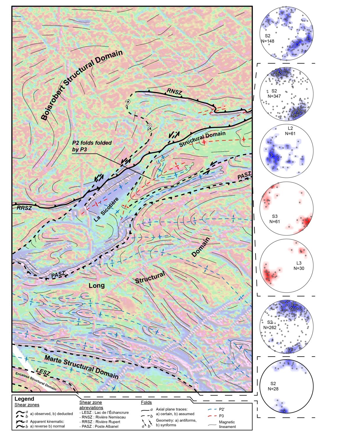
STRUCTURAL DOMAINS
The lithological, structural and geophysical criteria allow the region to be subdivided into five lithotectonic domains, which are the structural domains of Boisrobert, La Sicotière, Long, Marte and Encaissé. To the north, the Boisrobert Structural Domain forms the southern extension of the La Grande Subprovince. The other four structural domains to the south belong to the Nemiscau Subprovince.
In the descriptions that follow, the two main deformation phases identified in the region are referred to as D2 and D3, and refer to the regional nomenclature that has already been used by Bandyayera and Daoudene (2017). A D2' phase has been introduced here. It reflects a first regional folding phase of the main planar factory S2, but which likely occurred along the D2 deformation continuum.
Boisrobert Structural Domain
The Boisrobert Structural Domain, previously known as the Lac Champion Plutonic Terrain (Bandyayera and Daoudene, 2018), is composed mainly of intrusive rocks of intermediate to felsic composition. Generally, the more differentiated the rock is, the less deformed it is. Thus, diorites and tonalites show very marked penetrative S2 foliation, usually gneissic, while granodiorites and granites are not or little deformed. At the domain level, S2 foliation is oriented E-W to NE-SW (structural map). The structural domains of Boisrobert and La Sicotière are separated by the Rivière Rupert and Rivière Nemiscau shear zones.
La Sicotière Structural Domain
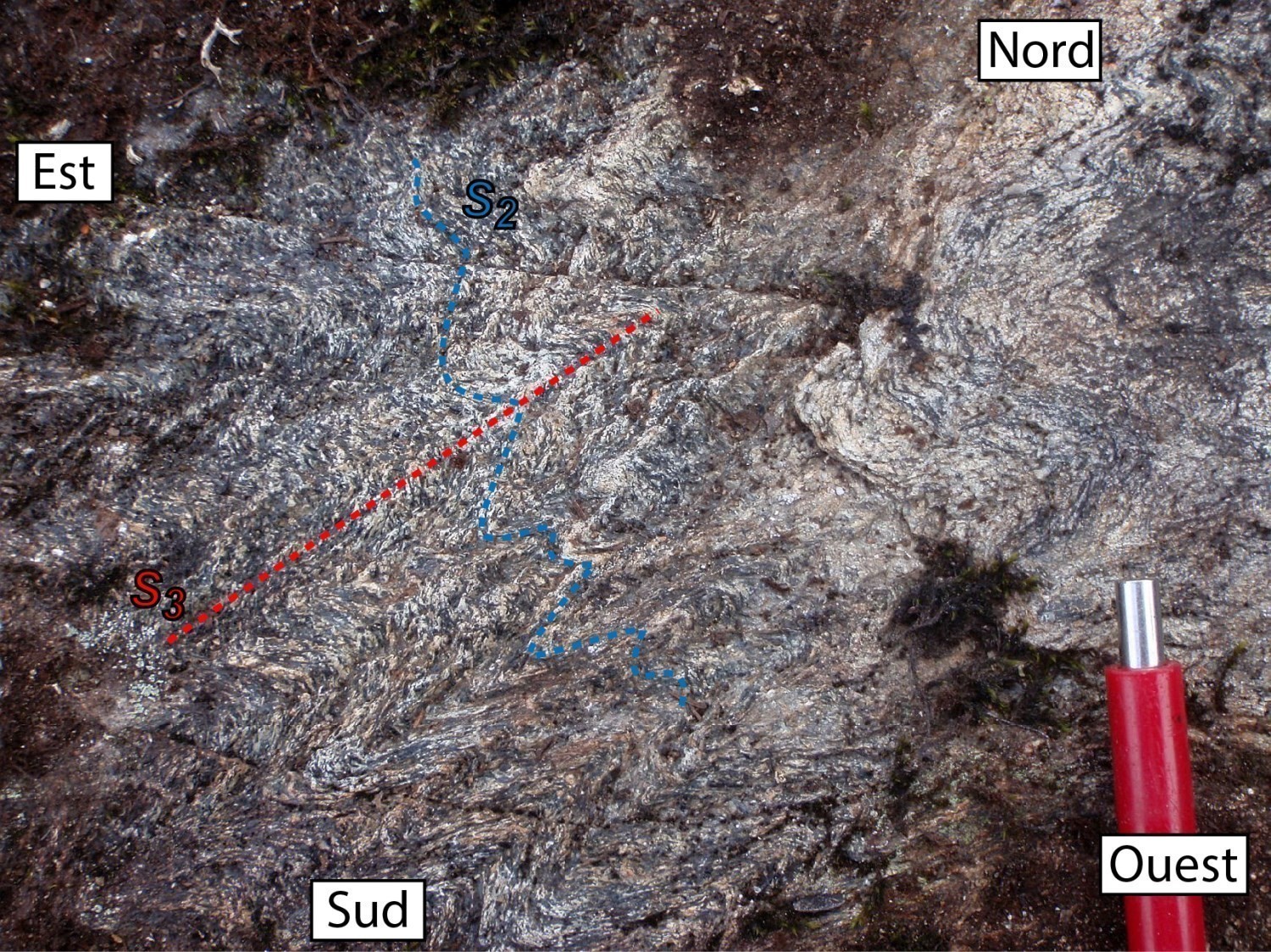
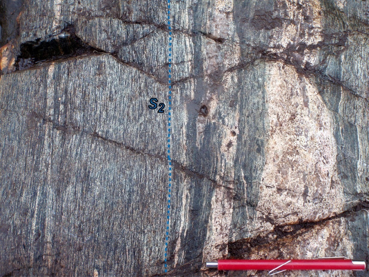
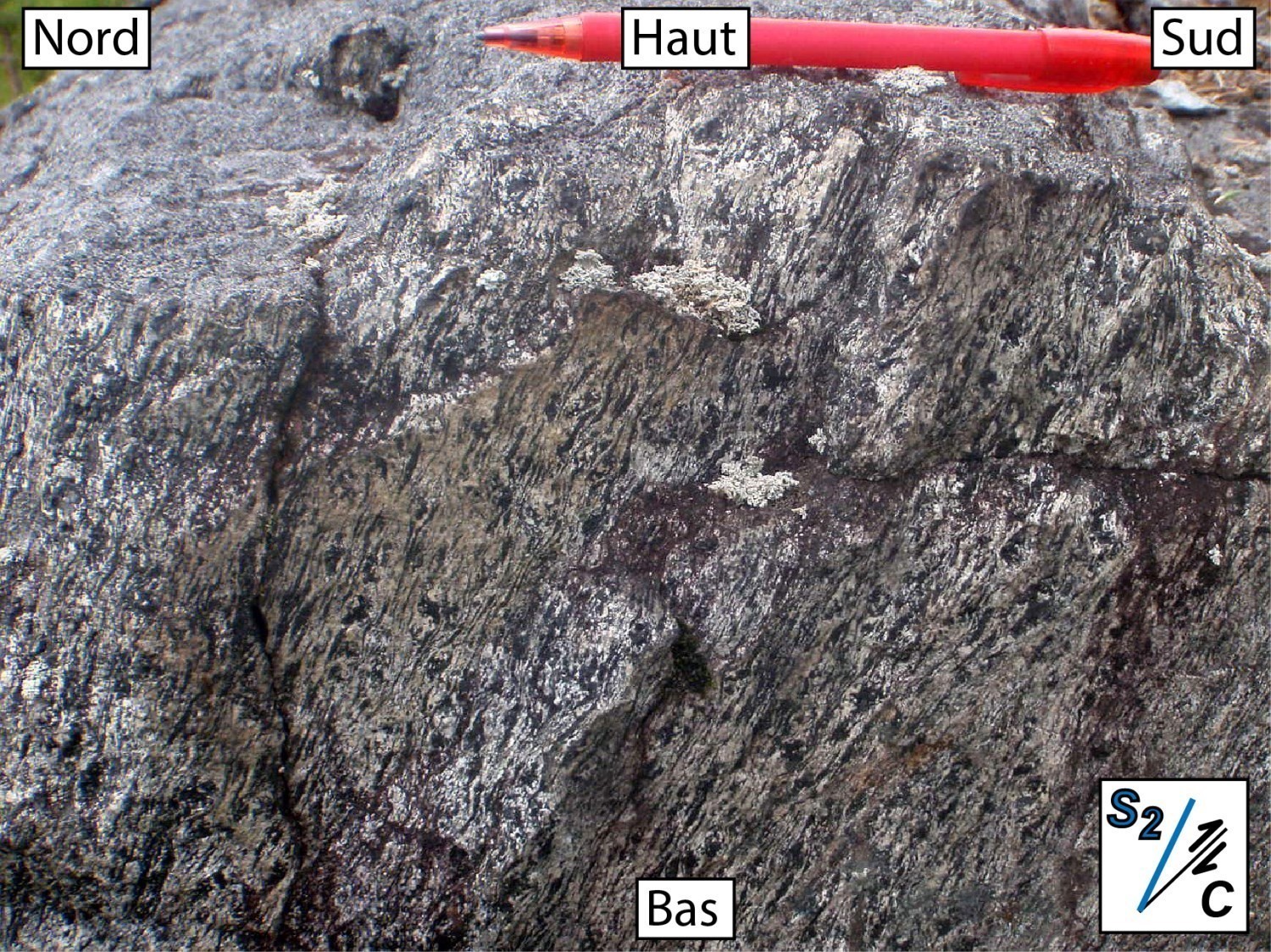
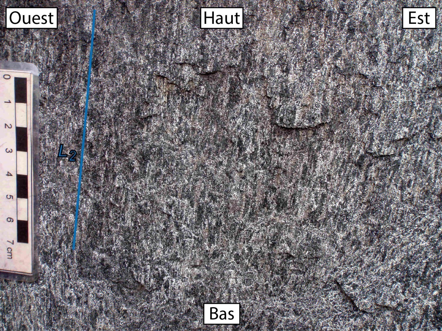
The La Sicotière Structural Domain is the one that shows the greatest diversity in terms of lithologies; paragneiss little or not migmatitized, metavolcanic rocks, iron formations, ultramafic-mafic sills and various felsic intrusive bodies. This domain also shows structural fabrics associated with at least two deformation phases, D2 and D3. The early D2 phase corresponds to migmatitic banding of paragneiss, a penetrative foliation in volcanic and sedimentary units (outcrop 2017-DB-1030), and gneissosity in some intrusive units. S2 foliation is generally marked by the preferential orientation of biotite and hornblende, as well as flattening of quartz and feldspath grains in the most deformed rocks. At the domain level, although S2 foliation appears to be predominantly ENE-WSW with a strong dip, its attitude is variable (structural map). S2 foliation bears a mineral lineation L2, which often dips to the SW at a moderate angle.
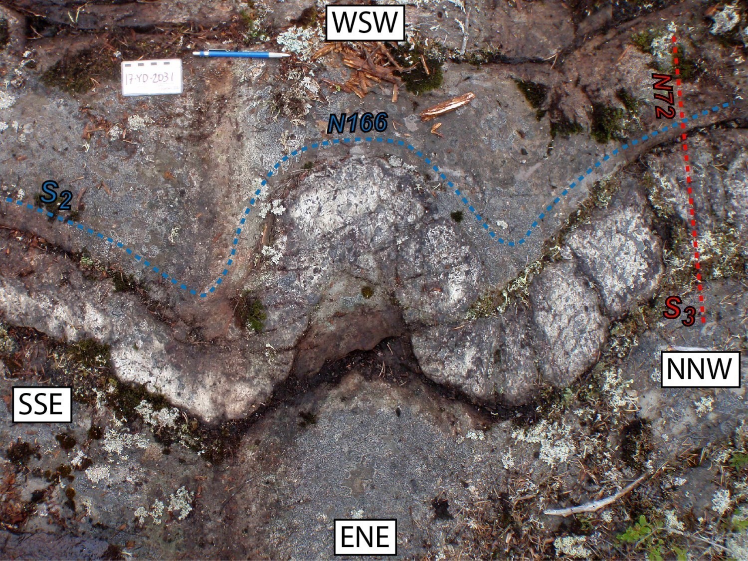
In the La Sicotière Structural Domain, foliation S2 is commonly overprinted by a more spaced S3 crenulation schistosity (outcrop 2017-DB-1030). Under the microscope, S3 schistosity is observed by the preferential orientation of chlorite, actinolite-tremolite or sericite grains, minerals typically associated with greenschist facies metamorphic conditions. Regionally, it is NE-SW oriented and has a dip greater than 70° (structural map). It bears a mineral and stretching lineation that generally dips slightly towards the SW.
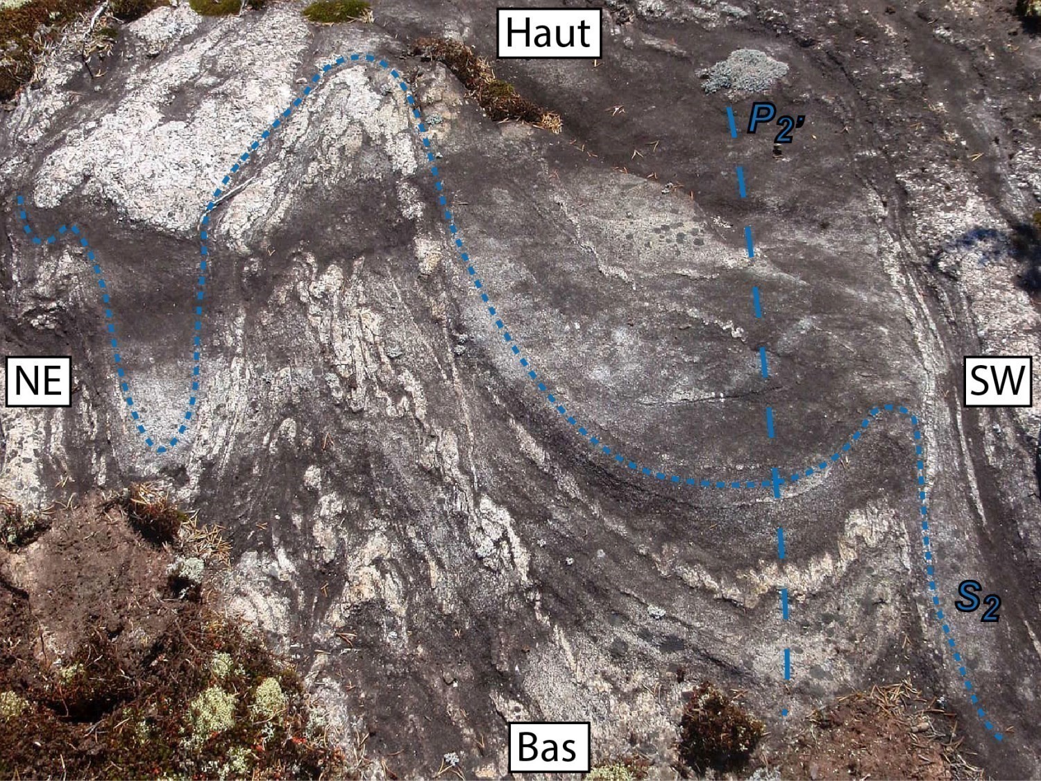
Regionally, the La Sicotière Structural Domain seems to form a vast synform, more or less well delineated to the north and south by units of the Lac Montagnes Group, and essentially filled by paragneiss of the Rupert Complex. This synform could have developed late in the D2 phase (during a D2' phase) as S2 foliation was regionally folded first before the D3 phase. Indeed, magnetic field maps show at the heart of the domain fold geometries that could be the result of at least two deformation phases, which also seems to be marked by the trajectory of the main S2 fabric (structural map). P2' folds would have been folded by axial NE-SW folds subparalated to S3 schistosity. At the outcrop scale, P3 folds are open to tight (outcrop 2017-YD-2031) and have strongly dipping axes. Two phases of folding could explain the dismemberment, across the La Sicotière Domain, of units of the Lac des Montagnes Group, which are by their nature more competent than those of the Rupert Complex (geological map). They could also explain the presence of a tonalitic gneiss dome of the Champion Complex, probably exhumed during the D3 phase, in the heart of the domain.
Long Structural Domain
The Long Structural Domain is distinguished primarily from the previous one by the scarcity of volcanic rocks, the presence of migmatites after paragneiss showing a very high proportion of mobilisate, and by numerous granodiorite and gneissic tonalite blocks. In this domain, the main planar fabric S2 is expressed by migmatitic banding of paragneiss (outcrop 2017-FT-3061) and by gneissosity or penetrative foliation in certain felsic intrusive rocks (outcrop 2017-PA-8045). Macroscopically and depending on the rock type, this S2 foliation is marked by the preferential orientation of biotite and hornblende. The La Sicotière Intrusive Suite locally exhibits magmatic foliation (outcrop 2017-RP-6101), which is conformable with the S2 foliation of neighbouring units. This feature seems to indicate intrusion more or less contemporaneous with the D2 deformation. To the west of the domain, S2 foliation is oriented E-W, but gradually turns towards the SE in the southeast. This domain, which is affected by P2' folds, has overall dome and basin geometry.


Marte Structural Domain
The Marte Structural Domain is mainly composed of migmatites after paragneiss, whose mobilisate ratio is generally greater than 30%. Within this domain, S2 foliation, underlined by very clear migmatitic banding, is regularly oriented WNW-ESE and generally has a strong dip (structural map).
Encaissé Structural Domain
The Encaissé Structural Domain, previously known as the Lac Encaissé Sub-Domain (Bandyayera and Daoudene, 2018), forms the southwestern corner of the mapped area. The few structural data that have been measured here do not describe the domain architecture in sheet 32N08 (structural map). However, to the west, in sheets 32N06 and 32N07, Bandyayera and Daoudene (2018) describe the structure of this domain in domes and basins. The main planar fabric S2 is E-W and has a strong dip. It is mainly marked by migmatitic banding of paragneiss of the Rupert Complex in the basin areas, and by foliation and gneissosity of felsic and intermediate intrusive rocks of the Champion Complex in the dome areas.
MAIN SHEAR ZONES
Rivière Rupert Shear Zone
In the western part of the mapped area, the Rivière Rupert Shear Zone (RRSZ) separates the Boisrobert Structural Domain in the north from the La Sicotière Structural Domain in the south. The RRSZ is the boundary between the La Grande and Nemiscau subprovinces in the region. It has already been described in detail in sheets 32N06 and 32N07 (Bandyayera and Daoudene, 2018). In the Champion Lake area, the RRSZ is marked by numerous corridors of extreme deformation, from metric to decametric thickness, affecting all units of the Lac des Montagnes Group. Within these deformation corridors, the original rock is generally unrecognizable or difficult to identify. Foliation is usually mylonitic (outcrop 2017-DB-1030) and bears a strong stretch lineation, of variable orientation, but with a dip generally between 40 and 60° eastward. The kinematic indicators, such as the C/S fabric in a sheared gabbro (outcrop 2017-RP-6037), suggest that the movement of the RRSZ has an inverse vertical component. With the dip of S2 foliation frequently moving northward, the movement of the RRSZ would have allowed uplift of the Boisrobert Structural Domain relative to that of La Sicotière.
Rivière Nemiscau Shear Zone
Like the RRSZ, the Rivière Nemiscau Shear Zone (RNSZ) delineates, in the eastern part of the mapped area, the Boisrobert Structural Domain from that of the La Sicotière. Although the two shear zones cannot be correlated on a map, they separate the same units and show similar structural characteristics. Thus, the RNSZ is also characterized by the presence of numerous corridors of intense deformation, from metric to decametric thickness, cutting all the rocks of the Lac des Montagnes Group. Within these corridors, mylonitic foliation bears a mineral and stretching lineation whose steep dip (outcrop 2017-YD-2058) is indicative of a predominantly vertical movement. Kinematic indicators observed along the RNSZ (outcrop 2017-YD-2070) also suggest that the Boisrobert Structural Domain was uplifted relative to the one of La Sicotière.

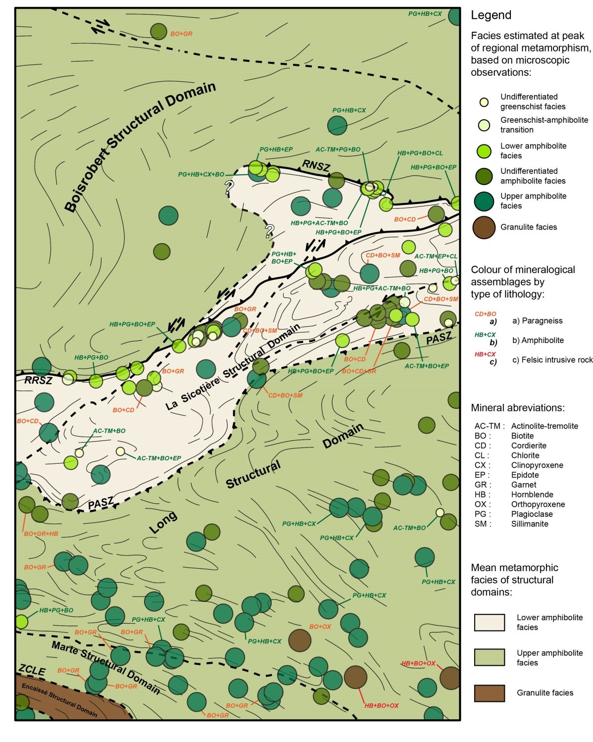
Poste Albanel Shear Zone
The Poste Albanel Shear Zone (PASZ) is not well exposed in outcrop. In its path, gneissic rocks and granitic injections are heavily deformed and quartz veins are boudinaged. The PASZ marks the boundary between two very contrasting domains of the Nemiscau Subprovince (structural map). In the north, the La Sicotière Structural Domain is composed of a wide variety of lithologies, including paragneiss, which are generally little or not migmatitized. On the other hand, in the south, the Long Structural Domain is less diverse in terms of lithologies and paragneiss composing it are generally very rich in mobilisate, reflecting a higher metamorphic facies. Microscopic observations of samples from both sides of the PASZ support this interpretation (see metamorphism chapter below). At the same time, the domains on both sides of the PASZ show different structural characteristics. The Long Structural Domain appears to have been affected by a single phase of folding, while the La Sicotière Structural Domain shows at least two.
Metamorphism
The majority of Archean rocks in the region show mineralogical assemblages and structural characteristics that indicate a high-temperature regional metamorphic event.
South of the PASZ, the Rupert Complex is represented by diatexites that typically have a high percentage of mobilisate (>50%). In the Long Structural Domain, mafic rocks consistently have plagioclase, hornblende and clinopyroxene mineralogy, indicating that they have reached the upper amphibolite facies (metamorphic map). Hornblende and clinopyroxene mark S2 foliation. In the southeastern part of the domain, the presence of orthopyroxene in a paragneiss and in felsic to intermediate intrusive rocks attests to the fact that certain areas of the Long Structural Domain have reached the granulite facies.
The La Sicotière Structural Domain has significant variability in terms of mineralogical assemblages associated with particular metamorphic conditions (metamorphic map). Some areas have cordierite and sillimanite paragneiss, typical of the upper amphibolite facies. Cordierite forms flattened poikiloblasts perpendicular to S2 foliation; their growth thus appears to be early in the D2 deformation phase. Sillimanite, in fibrolite clusters or more rarely in euhedral prisms, marks S2 foliation. In other areas of the domain, mafic volcanic rocks show metamorphic assemblages of hornblende and/or actinolite-tremolite, biotite and epidote, reflecting lower temperature conditions typical of the lower amphibolite facies or the greenschist facies. The variability of metamorphic conditions within the La Sicotière Structural Domain could be linked to its architecture, which would result from at least two phases of deformation (structural map). According to this hypothesis, the second phase of folding during event D3 may have folded the previously developed isogrades during phase D2. The main shear zones in the region may also have played an important role in the distribution of metamorphic facies. Indeed, these appear to coincide with areas where mafic rocks show metamorphic mineral assemblages generally associated with lower temperatures. In these areas, hornblende is commonly retrograded into actinolite-tremolite, biotite is chloritized, and epidote growth is overprinted on primary S2 foliation.
In the Boisrobert Structural Domain, metamorphic conditions experienced by older units are difficult to determine given their nature. However, tonalitic or granodioritic gneiss show dynamic recrystallization textures, typically associated with high-temperature metamorphic conditions. Quartz and feldspars show evidence of the dynamic migration of their grain borders. These are usually large, very rounded or amiboid. The usual presence of quartz grains with chessboard texture suggests that metamorphic conditions have reached the upper amphibolite facies. This is corroborated by the presence of clinopyroxene in amphibolite enclaves within granites and granodiorites (metamorphic map).
Economic Geology
Six prospective zones for base or precious metal mineralization have been identified in the Champion Lake region. These mineralizations can be classified into 3 types:
- magmatic nickel-copper mineralization (± chromium ± cobalt ± platinum group elements) associated with mafic to ultramafic intrusions in the Lac des Montagnes Group volcano-sedimentary sequence;
- polymetallic mineralization (copper ± iron ± zinc ± gold ± silver) associated with disseminated sulphide horizons or massive to semi-massive sulphide lenses in the Lac des Montagnes Group volcano-sedimentary sequence;
- exhalative sulphide mineralizations (zinc-silver ± lead ± gold) associated with stratiform horizons in paragneiss of the Rupert Complex.
The showing table below presents the results of analyses for the ten known showing in the area, as well as the one that was uncovered as part of our work.
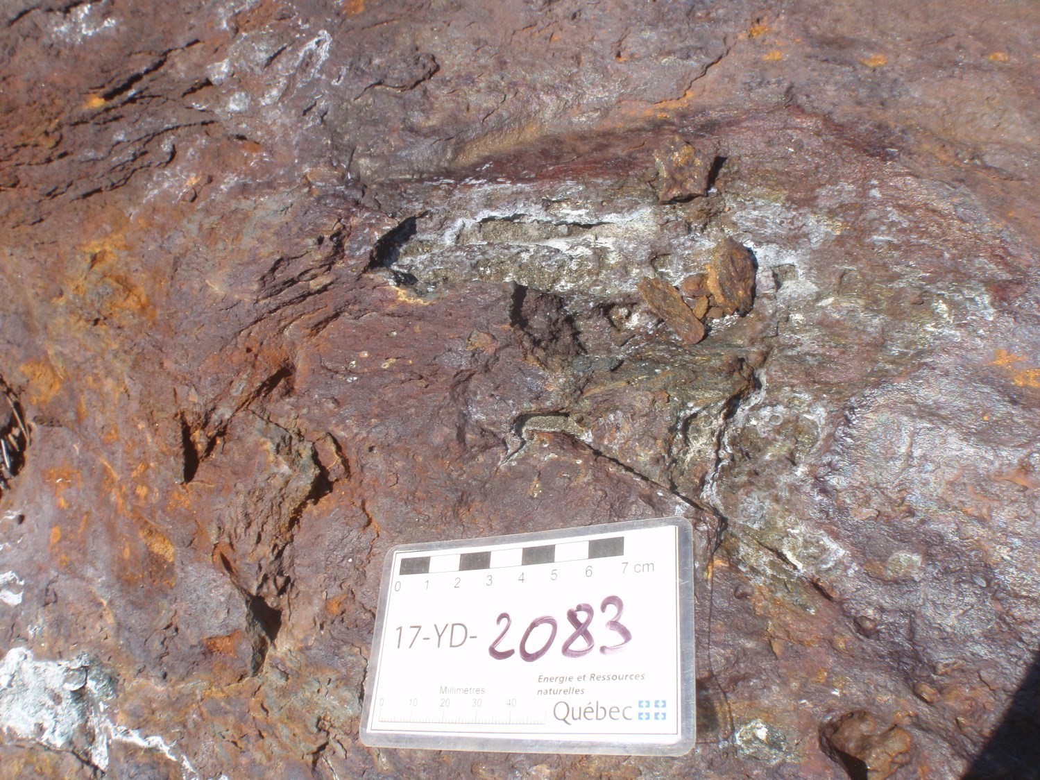
2017 complementary analysis: 1.21% Cu, 0.572% Ni, 27.7% Fe, 0.081% Cr, 0.071% Co, 2.6 ppm Ag and 0.231 ppm Pd (E) (17YD2083-E2, SGDAC 2017069958)
2017 complementary analysis: 23.6% Fe, 0.039% Cu, 342 ppb Au and Ag content below detection limit (<0.05 ppm) (E) (17YD2073-B1, SGDAC 2017069908)
2017 complementary analysis: 1.59% Zn and 0.43% Pb (E) (17YD2093-B1; SGDAC 2017069960)
(E): selected sample; (R): channel; (F): drillhole
The table of lithogeochemical analyses of metals of economic interest provides the location, description and results of the 89 samples selected to assess the economic potential of the region.
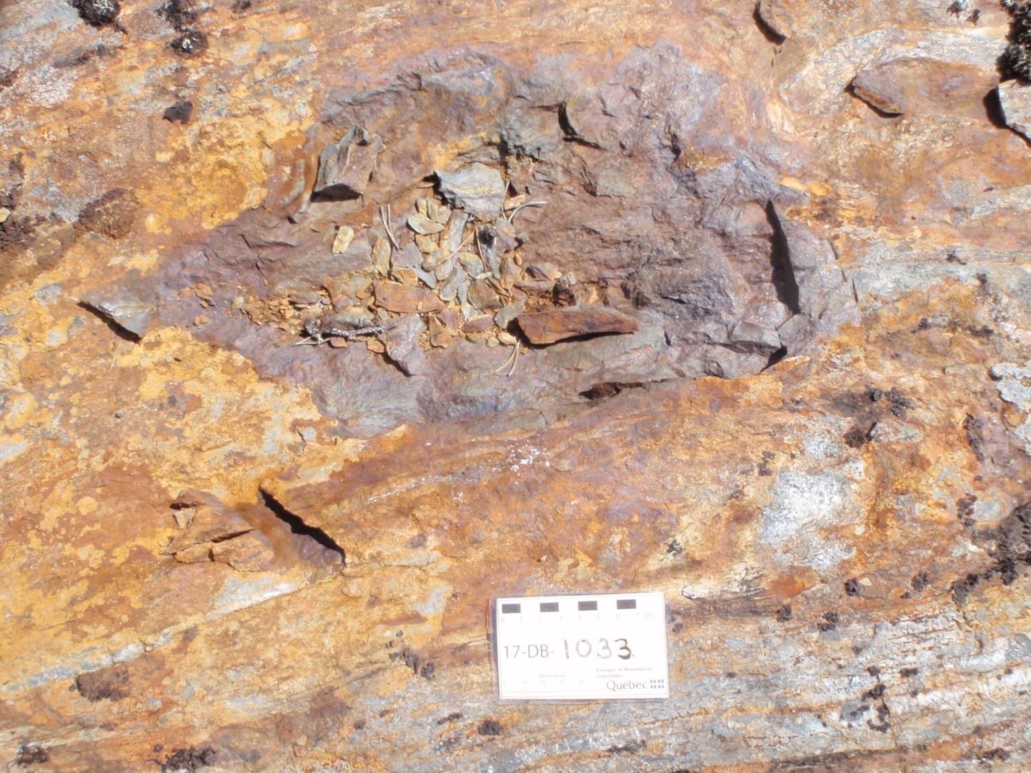
PROSPECTIVE ZONES FOR NI-CU±CR±CO±PGE MINERALIZATION SOUTH OF CAUMONT LAKE, SOUTHEAST OF CHAMPION LAKE AND SOUTH OF VALIQUETTE LAKE
 Mafic to ultramafic intrusions (gabbro, pyroxenite and peridotite), which are generally highly magnetic, have been recognized within the volcano-sedimentary sequence of the Lac des Montagnes Group. The mapping work carried out by the MERN in the summer of 2017 helped to clarify the spatial distribution of these intrusions (interactive map). They are divided into three prospective zones for magmatic Ni-Cu ±Cr±Co±PGE mineralization which are, from southwest to northeast, Lac Caumont-Sud, Lac Champion sud-est and Lac Valiquette sud. These long-shaped prospective zones are oriented NE-SW to E-W; they are between 3 and 7 km long and 400 to 600 m wide. Two of these zones (Lac Champion sud-est and Lac Valiquette sud) are marked positive anomalies on the magnetic field map. The third zone (Lac Caumont-Sud) comprises a string of small circular anomalies several hundred metres in diameter along the north edge of a long and very strong positive NE-SW anomaly. This latter anomaly may indicate the presence of an even more magnetic unit which may correspond to one or more horizons of iron formation. Exploration work has revealed the presence of rocks of this type in this region (Lévesque Michaud and Caron, 2012), but they were not observed in the field. Peridotites, gabbros and pyroxenites usually contain sulphides with contents up to 10% of the total volume of the rock. Sulphide grains are generally finely disseminated. Locally, they form millimetre-thick veins.
Only the prospective zone of Lac Caumont-Sud is associated with Ni-Cu-PGE showings. A compilation of statutory work contents reveals 28 analyses that are equal to or greater than 0.25% Ni, 26 analyses greater than or equal to 0.50% Cu, 36 analyses greater than or equal to 200 ppb Pd and 3 analyses greater than or equal to 200 ppb Pt. Several samples contain showing levels of copper, nickel, palladium, platinum, silver and gold (table). Although no showing value has been obtained at this time in the prospective zones Lac Champion sud-est and Lac Valiquette sud, statutory reports have shown that outcropping mafic and ultramafic intrusive rocks have significantly high contents of nickel (1245 ppm), copper (385 ppm), chromium (1710 ppm) and cobalt (111.5 ppm) locally (Lévesque-Michaud and Lalancette, 2012; Tremblay and Lalancette, 2013).
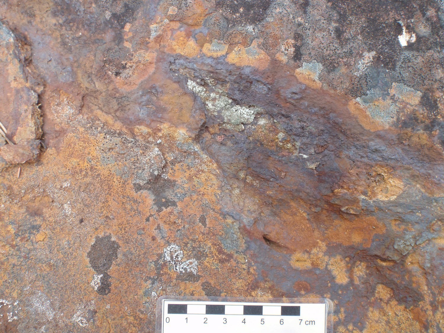
LAC DES MONTAGNES GROUP, A PROSPECTIVE ZONE FOR POLYMETALLIC DEPOSITS
 The Lac des Montagnes Group is composed of volcanic and sedimentary rocks, metamorphosed to the amphibolite facies. These rocks contain disseminated sulphides in places or in the form of laminae or platings in fractures. The sulphide content can be as high as 10%. In addition, this unit contains many decimetric to metric alteration zones rich in chlorite and sericite. These heavily rusted alteration zones are arranged parallel to regional foliation and generally correspond to areas of high deformation. Altered volcanic rocks can be intensely silicified and very rich in garnet (up to 20%). This high garnet content is associated with significant amounts of chlorite and/or sericite, suggesting a volcanogenic origin. Massive to semi-massive sulphide horizons or lenses are regularly observed in association with these zones.
Prior to our work, three polymetallic showings were listed in the Lac des Montagnes Group. At showing L943004, one paragneiss sample containing disseminated pyrite and two massive sulphide samples provided up to 30.2% Fe, 4.02% Cu and 16.10 ppm Ag (Lévesque Michaud and Caron, 2012). At the Lac Caumont-SE showing, analysis of a quartz vein in contact with a zone rich in muscovite and arsenopyrite yielded a value of 1.6 ppm Au (Lalancette and Lévesque Michaud, 2012). The third showing L947012, located approximately 7 km west of Valiquette Lake, exhibits a rusty 20 m long by 1 m wide zone from which a massive pyrrhotite sample was collected that provided 6.0 ppm Ag (Tremblay and Lalancette, 2013). In addition to these showings, several anomalous values in Fe, Zn, Ni, Cu, Ag and Au were reported in the three prospective zones of the mapped area (Lévesque Michaud and Caron, 2012; Tremblay and Lalancette, 2013).
PROSPECTIVE ZONES FOR ZN-AG±PB MINERALIZATION ASSOCIATED WITH STRATIFORM EXHALATIVE SULPHIDE HORIZONS SOUTH OF INDIEN LAKE
 Usually weakly or not migmatitized paragneiss of the Rupert Complex outcropping south of Indien Lake contain stratiform horizons prospective for Zn-Ag ±Pb±Au mineralization. This 9 km by 1 km zone, oriented NE-SW, has many rusted alteration zones of metre thickness rich in chlorite and disseminated sulphides (trace to 25%). Some of these alteration zones correspond to high deformation ENE-WSW corridors. Alteration zones also contain
lenses or boudinaged centimetric horizons of semi-massive sulphides. Valiquette (1975) noted this prospective zone in its geological report (rusted zone, Figure 47 and Map 1756).
The prospective zone includes three lead, zinc and silver showings that were uncovered as a result of exploration (Lalancette and Tremblay, 2013). On the Lac de l'Indien showing, samples from a stratiform metric horizon with alternating carbonate and sphalerite- galena silica beds gave up to 4.64% Zn, 3.05% Pb and 2.15 ppm Ag. At showings L942709 and L942416, a paragneiss containing 10% pyrrhotite and pyrite in veinlets and a semi-massive pyrite horizon have contents of 0.7% Zn and 9.24 ppm Ag. The prospective zone also has about 40 anomalies in Zn (0.102-0.728%), three in Pb (0.14-0.387%), 20 in Ag (1.02-2.7 ppm) and five in Au (66-285 ppb). These anomalies are mainly hosted in more or less graphitic and magnetic paragneiss that can contain up to 25% sulphide, or in semi-massive sulphides (Lalancette and Tremblay, 2013). The location of these anomalies coincides with a strong positive magnetic anomaly that passes through the prospective zone from east to west. The stratiform appearance of alteration zones and their enrichment in Zn, Pb and Ag indicate that this prospective zone is conducive to the presence of exhalative sulphide horizons in a volcano-sedimentary setting.
| Authors | Daniel Bandyayera, P.Geo., Ph.D. daniel.bandyayera@mern.gouv.qc.ca Yannick Daoudene, P.Geo., Ph.D. yannick.daoudene@mern.gouv.qc.ca |
| Geochemistry | Fabien Solgadi, P.Geo., Ph.D. |
| Geophysics | Siham Benhamed, GIT, M.Sc. Rachid Intissar, P.Geo., M.Sc. |
| Potential assessment | Hanafi Hammouche, P.Geo., M.Sc. |
| Logistics | Clotilde Duvergier, GIT, B.Sc. |
| Geomatics |
Julie Sauvageau Karine Allard |
| Editing | Céline Dupuis, P.Geo., Ph.D. |
|
Critical review and update of deposit records |
James Moorhead, P.Geo., M.Sc. Jean Goutier, P.Geo., M.Sc. Alban Duvernois, Jr. Eng. Pierre Lacoste, P.Geo. |
| English version | Céline Dupuis, P.Geo., Ph.D. |
| Organism | General direction of Géologie Québec, Ministère de l'Énergie et des Ressources naturelles, Government of Québec |
Acknowledgements:
This Geological Bulletin was made possible through the cooperation of many people. We thank geologists Francis Talla Takam and Charles St-Hilaire, geologists-in-training Rocio Pedreira Perez, Morgann Perrot and Pape Doudou Tague, and students Pierre-Argoud, Aboubacar Sidiki Koulibaly, Hubert Langevin, Claudia Perreault, Amy Laberge, Ariane Savaria and Carl Philippe Folkensson. We salute the excellent work of cook Yves Brisson and camp man Jolyn Hébert. The construction of the camp by CIVILCO was supervised by Stéphane Carignan of the Ministère. Field transportation was provided by Panorama Helicopter Inc. Pilots Christophe Chatel and Jérôme Roy, as well as mechanics Philippe Pednault and Antonin Larochelle, performed their work effectively and professionally.
References
Publications available through Sigeom Examine
Other publications
BANDYAYERA, D., DAOUDENE, Y., 2018. Geology of the Champion Lake Region, La Grande and Nemiscau Subprovinces, East of Waskaganish, Eeyou Istchee James Bay, Quebec, Canada. MRNF; BG 2018-06, 2 plans.