| Author(s) | Beauchamp, 2020 |
| Methodology | Defined from geological survey and geopysical data |
| Geological(s) subdivision(s) | Superior Province/Opatica Subprovince |
| Main movement | Does not apply |
| Deformation style | Homogeneous |
| Metamorphic facies (mean facies related to main deformation) | Undetermined |
Background and Methodology
The Cadieux Structural Domain was defined by Beauchamp (2020) following a mapping survey conducted in the Cadieux Lake area in the summer of 2018, in addition to the analysis of SIGÉOM aeromagnetic surveys (D’Amours, 2011). Chartier-Montreuil et al. (2025) have extended the domain to include a greater proportion of rocks belonging to the Misasque Complex, based on geophysical processing by Cleven et al. (2020) and mapping work in the Emmanuel and Léran lake areas (Massei and Hammouche, 2016; Talla Takam and Beauchamp, 2016). The Cadieux Structural Domain takes its name from the eponymous lake located at the centre of NTS sheet 33A07.
Boundaries and Morphology
| Width (km) | 10 to 25 |
| Length (km) | 115 |
| Orientation | NE-SW elongation |
The Cadieux Structural Domain corresponds to a NE-SW trending layer that is parallel to the UEGB and the Dolent Structural Domain, located to the SE. The Digne Shear Zone borders this contact. At its southernmost boundary, the Cadieux Domain is in intrusive contact with the Eastmain-Sorbier Shear Zone. The western part of the domain is occupied by paragneiss and granite from the Opinaca Subprovince, which do not belong to any formally defined structural domain. The metasedimentary rocks of the Ayr and Kaawaischiskau structural domains correspond to the NW-boundary of the Cadieux Domain. This boundary coincides with the contact between the Opatica and Opinaca subprovinces. Finally, the NE corner of the domain is occupied by the Wahemen Structural Domain.
Stratigraphic Units Concerned
The Cadieux Structural Domain is composed of intrusive rocks of the Opatica Subprovince. It comprises the following lithostratigraphic and lithodemic units:
- the MacLeod Batholith (nAmcl);
- the Misasque Complex (Amiq);
- the Digne Pluton (mAdig);
- the Dutreuil Suite (nAdut1).
Structural Characteristics
❯ Main Fabrics
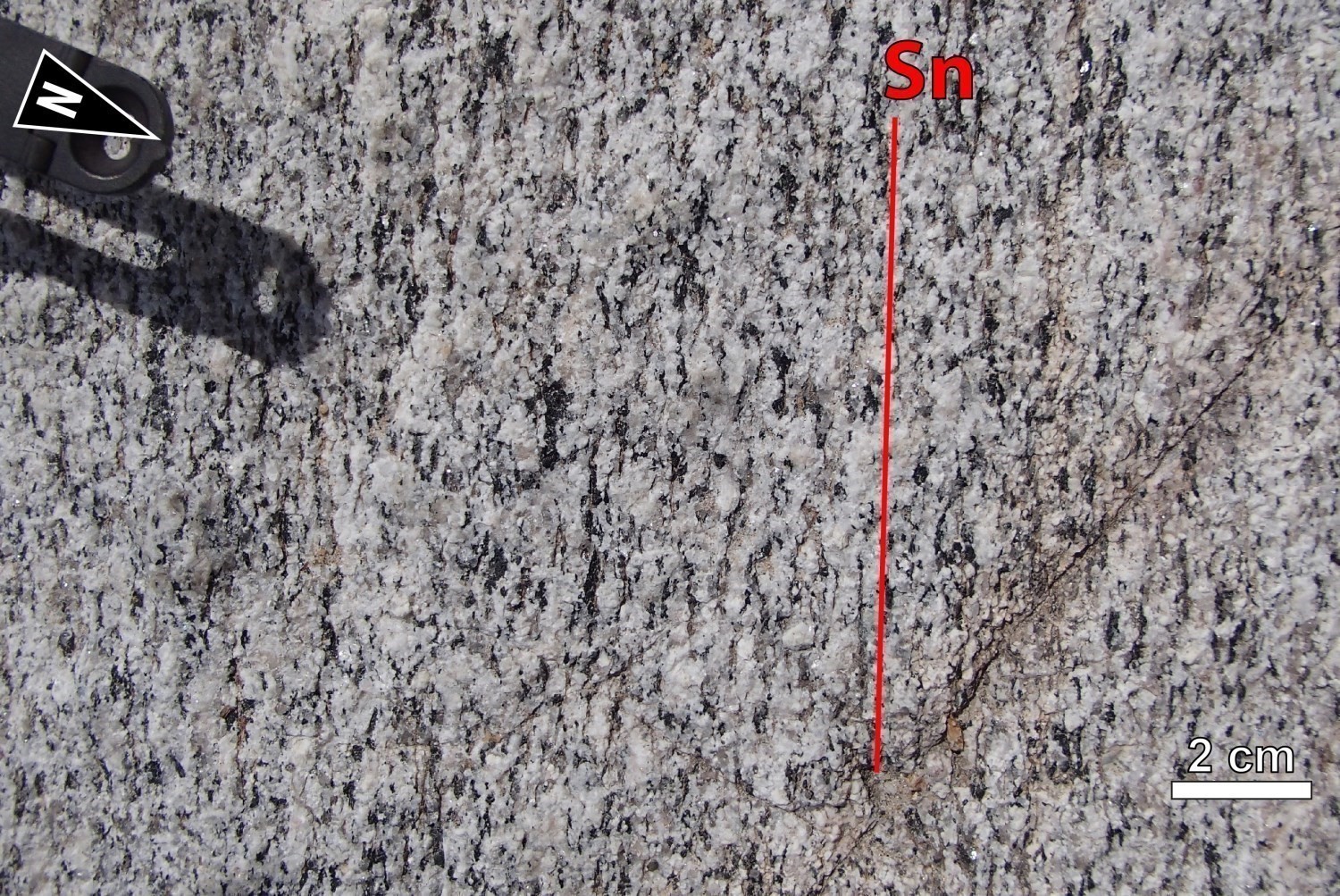
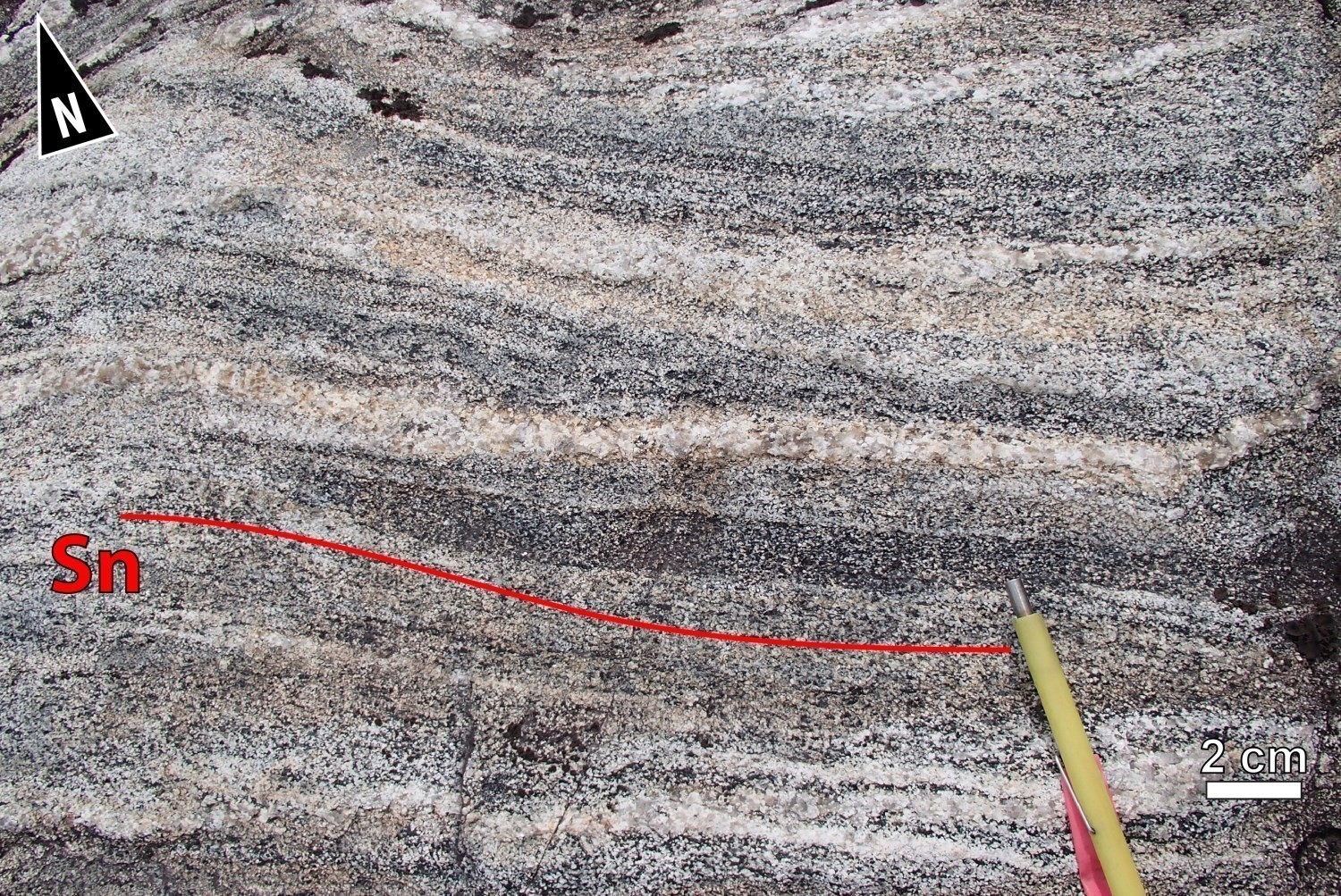
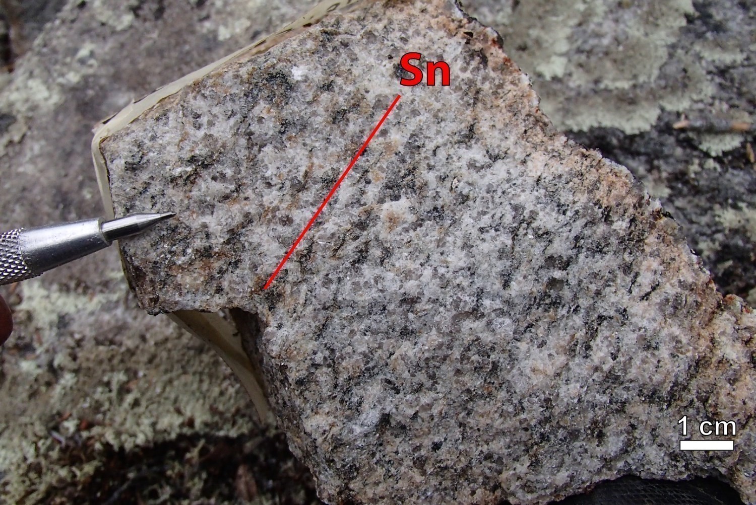
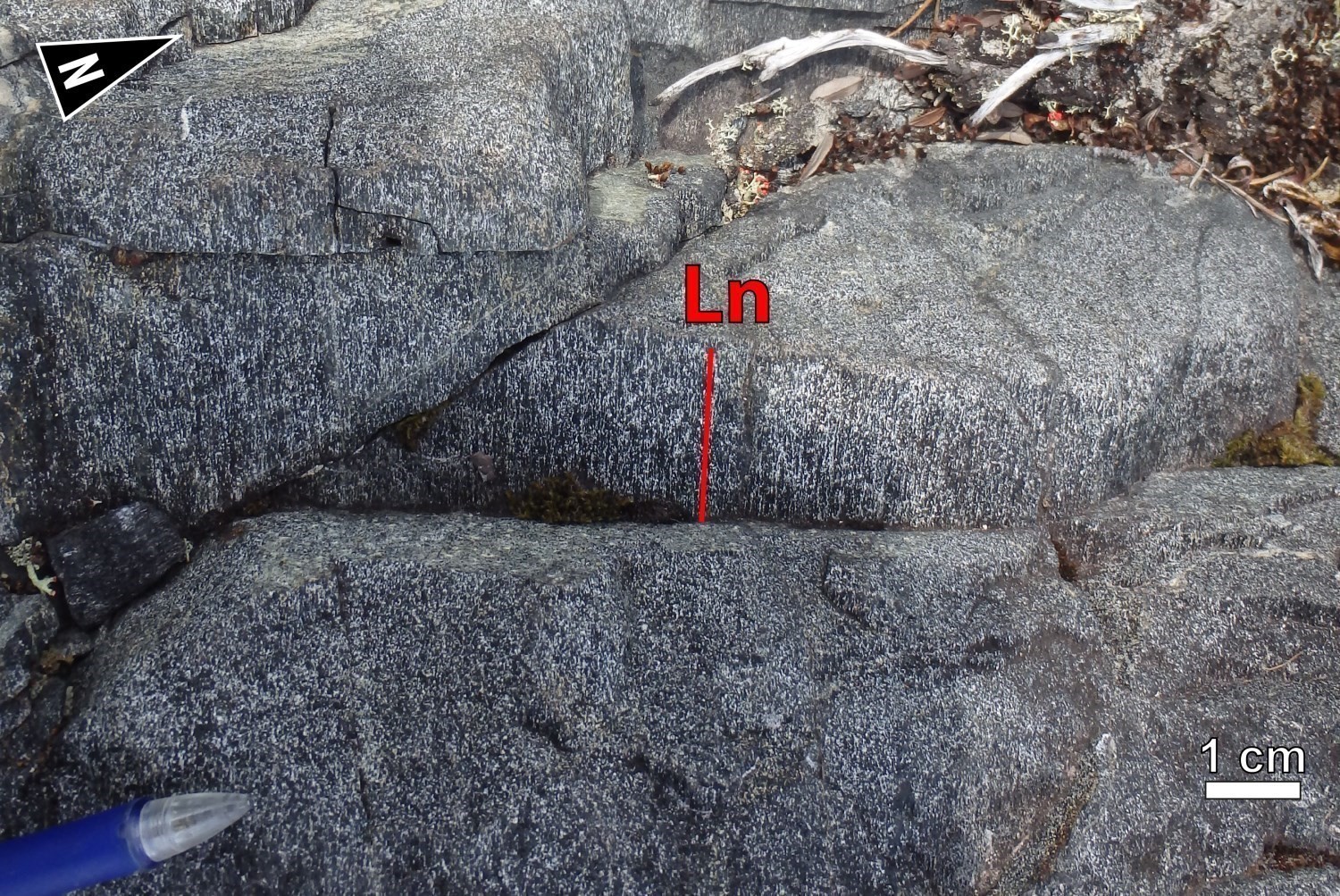 The main Sn fabric present in the Cadieux Structural Domain is a moderately developed penetrative foliation defined by the preferential alignment of ferromagnesian minerals (biotite, hornblende) affecting the MacLeod Batholith and Digne Pluton. Millimetric to centimetric lenses of ferromagnesian minerals and foliated granoblastic diorite enclaves are aligned along the main Sn foliation in the MacLeod Batholith. In the Misasque Complex, the main fabric is marked by irregular and contrasting clear gneissosity, forming alternating mafic (biotite ± hornblende) and whitish quartzofeldspathic layers, and is accentuated by the presence of subconformable granitic injections.
The MacLeod Batholith and Misasque Complex are characterized by poorly developed Ln lineations defined by the stretching of hornblende. The Ln lineations are better developed in the southern part of the Digne Pluton, especially towards the Digne Shear Zone. The Ln lineations are also very present in highly granoblastic diorite and gabbro enclaves found in the Misasque Complex and Digne Pluton. These intermediate to mafic rocks make up the oldest units within intrusive suites and commonly form L>S tectonites.
At the scale of the Cadieux Structural Domain, even if the Sn foliation appears mainly oriented ENE-WSW with a moderate dip, its attitude is still variable. On the map, these variations, both in terms of orientation and dip, indicate that it is folded. The Sn foliation locally bears an Ln mineral lineation which often dips towards the NE at a moderate angle.
| Main Fabric | Type of Fabric | Direction (°) | Dip/Plunge (°) | Number of Measurements | Comments |
| Foliation Sn | Tectonometamorphic foliation and gneissosity | 302 | 23 | 201 | The Sn foliation poles are grouped around a major NNW axis, which highlights significant folding. |
| Lineation Ln | Stretch lineation and mineral lineation | 53 | 46 | 32 |
The plunge of lineations varies globally from NW to east. |
❯ Other Fabrics
Not observed.
❯ Folds
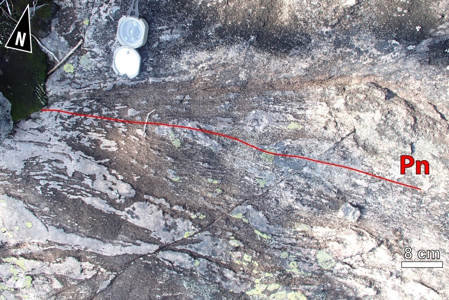 The MacLeod Batholith is structurally very homogeneous. The Sn foliation contains an Ln mineral lineation in places. Magnetic maps available on SIGÉOM (tilt and vertical gradient) and Rapid Eye Imagery indicate that the MacLeod Batholith is affected by a succession of antiformal and synformal folds. However, a very small percentage of outcrops visited exhibited folding. Outcrop 18-FM-2075, located at the edge of the batholith, exposes a diorite intensely deformed by a succession of tight to isoclinal folds. The E-W axial trace is particularly evident in felsic injections and silicified zones which are folded and in positive relief inside the diorite. Outcrop 18-PG-4080 also reveals that quartz monzodiorite and granitic injections are folded by Pn. The MacLeod Batholith appears to be saucer-shaped.
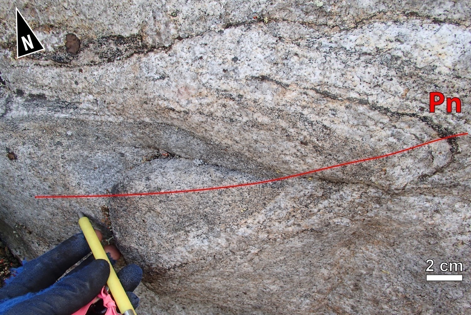 The Misasque Complex is very heterogeneous. It consists of a banded sequence of tonalite, quartz diorite and diorite injected by several generations of granite. A few Pn folds can be recognized on outcrops through magmatic flow textures. Alternating dip attitudes over short distances indicate that the unit comprises a series of ENE-WSW folds. An antiformal upright fold oriented ENE-WSW is interpreted in the NE part of the unit. It is possible that this fold is a major structure affecting the entire Cadieux Structural Domain and defining the theoretical dome required to exhume the Mesoarchean basement.
Although Sn foliation measurements tend to demonstrate that the Digne Pluton is also folded, no fold structure was observed in outcrops.
Geometric Parameters of Regional Folds:
| Fold or Family of Folds | Type (Anticline, Syncline or Undetermined) | Shape (Antiform or Synform) | Attitude (Overturned or Upright) | Axial Plane | Fold Axis | Position (Certain or Probable) | Deformation Phase | ||
| Direction | Dip | Direction | Plunge | ||||||
| Pn Fold | Undetermined | Antiform and synform | Mostly overturned, some upright | ENE-WSW | Unknown | – | – | Certain and probable | Dn |
❯ Crosscutting Relationships
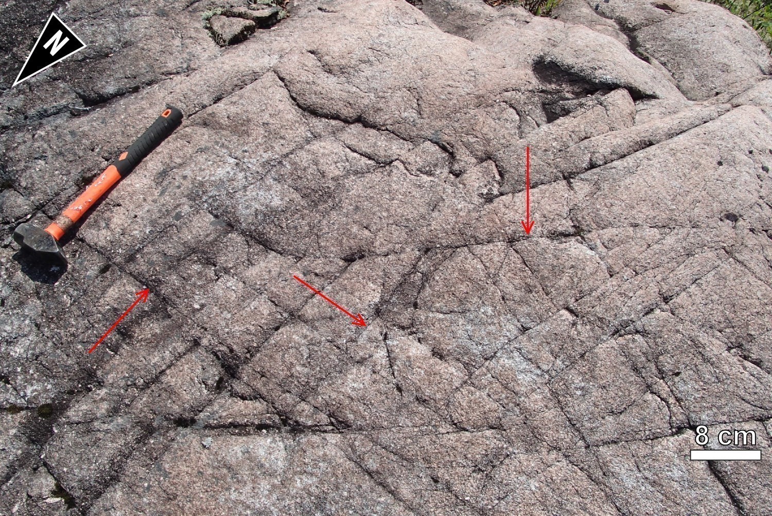
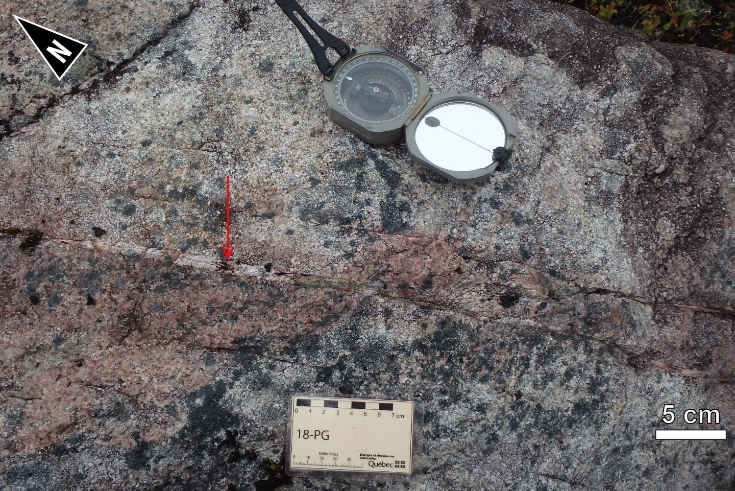 The Cadieux Structural Domain is cut by late faults that were inferred from the analysis of magnetic field maps.
In the SW portion of the domain, there is a family of subdecametric faults with apparent dextral or sinistral movement, locally offsetting the intrusive units of the Opatica Subprovince. Some field evidence indicates that they consist of slightly altered fault networks measuring <1 m wide. Some fractures cutting the MacLeod Batholith and Misasque Complex are hematitized and/or epidotized.
Geometric Parameters of Regional Faults Cutting the Cadieux Structural Domain:
| Fault or Family of Faults | Type | Mean Direction (°) | Mean Dip (°) | Lineation Plunge in the Fault Plane | Estimated Width (m) | Estimated Length (km) | Apparent Movement | Position |
| Family of faults | Regional faults | NNW-SSE to NW-SE | Steep | Unknown | <1 | 10 | Dextral | Probable |
| Family of faults | Regional faults | E-W | Steep | Unknown | <1 | >5 | Sinistral | Probable |
| Family of faults | Regional faults | NNW-SSE | Unknown | Unknown | Unknown | >50 | Dextral | Probable |
❯ Kinematics
Does not apply.
Deformation Style
This structural domain is relatively homogeneous and mainly affected by regional deformation Dn, which consists of a NNW-SSE shortening.
Metamorphic Characteristics
The mineralogical composition of intrusive rocks belonging to the Opinaca Subprovince is not sufficient to establish the metamorphic conditions that these rocks underwent. Since rocks in the adjacent structural domains have reached the amphibolite facies, it is very likely that the Cadieux Structural Domain rocks also reached these pressure and temperature conditions.
Alterations
The MacLeod Batholith is characterized by slight to strong alteration that appears to be zoned. Potassic alteration (biotite, magnetite and K-feldspar in variable amounts) is present in the centre of the intrusion. Propylitic alteration (quartz, chlorite and epidote) and silicification are located at the edge of the intrusion. Later hematite-epidote veinlets cut the Sn foliation, and remobilize part of the Cu-Mo-Ag-Au-W mineralization hosted in the MacLeod Batholith and in metasedimentary units surrounding the intrusion.
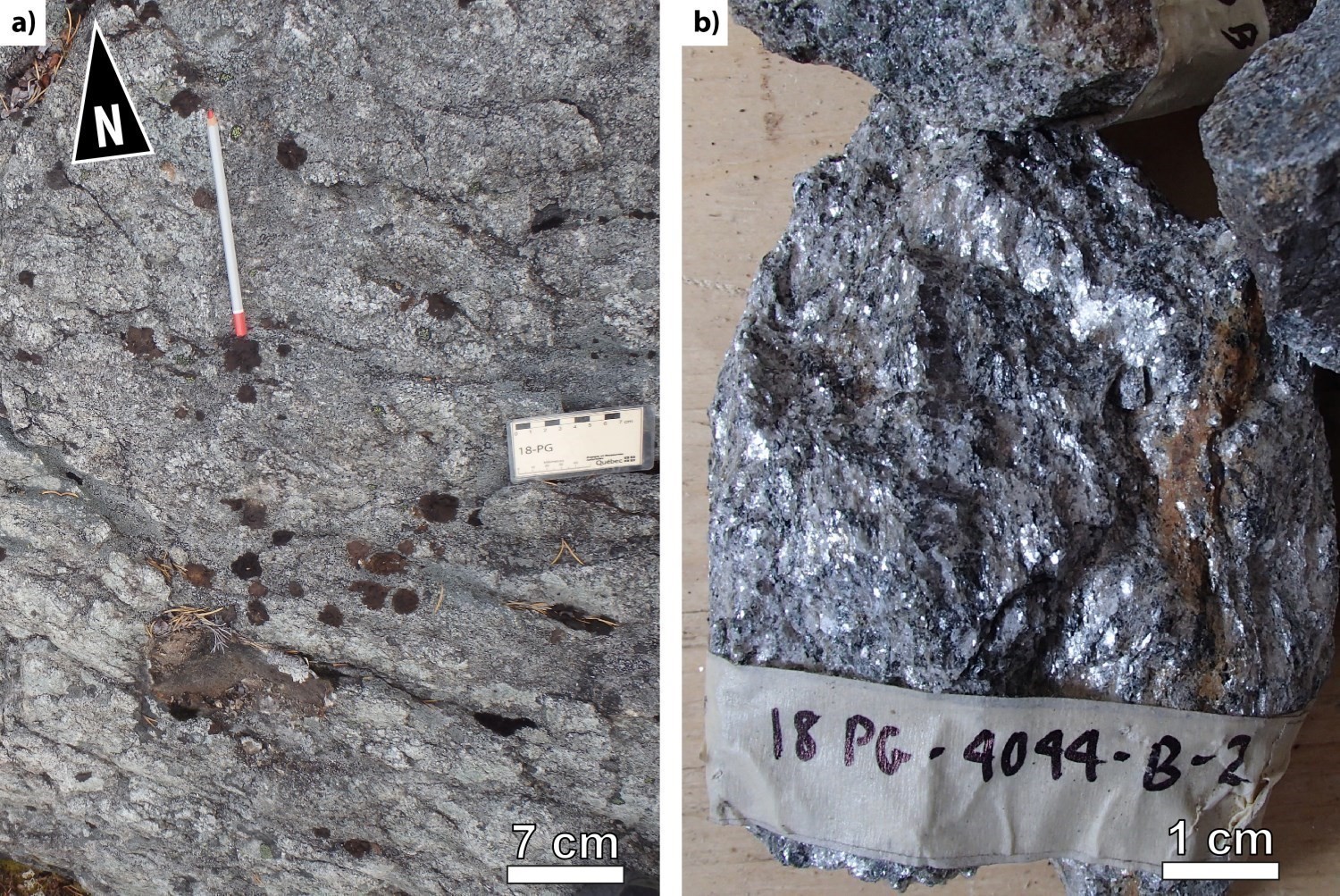
The rocks belonging to the Digne Pluton have undergone muscovitization, which seems to be of hydrothermal origin and transforms feldspar into an assemblage dominated by quartz and muscovite. Some outcrops expose anastomosing networks of muscovite veins and quartz veins (outcrops 18-PG-4044, 18-PG-4045 and 18-PG-4046).
Finally, with the exception of hematitization and epidotization in some outcrops, the Misasque Complex does not appear to be particularly altered.
Geophysical Characteristics
Residual magnetic field and vertical gradient maps reveal that this domain is relatively heterogeneous. On the residual magnetic field map, the Misasque Complex and MacLeod Batholith are characterized by high magnetic susceptibility. A high-density, moderately intense banded structure defines the pattern of rocks in the SW part of the Misasque Complex. This structure gradually fades towards the NE in favour of a more granulated pattern. The MacLeod Batholith has a lobed, homogeneous structure. The Digne Pluton is very homogeneous and has a low magnetic susceptibility. Magnetic lineaments, some of which are similar to the trace of the Sn regional foliation, are predominantly straight. Some lineaments are undulating, indicating the presence of possible folds. Families of brittle fractures are very apparent on magnetic maps.
Chronological Markers
The Dn deformation postdates the emplacement of the Digne Pluton (2814 ±7 Ma, Davis, 2019). It either postdates or is synchronous with the emplacement of the MacLeod Batholith (2704 ±2 Ma, Davis, 2019) and the youngest tonalitic phase dated in the Misasque Complex (2695 ±8 Ma, Davis and Sutcliffe, 2018; 2698 ±28 Ma, Davis, 2019). It is older than 2640 Ma (Davis and Sutcliffe, 2018) and corresponds to the age of the Wahemen Suite, which is unaffected by deformation and metamorphism.
References
Publications Available Through Sigéom Examine
BEAUCHAMP, A.-M., 2020. Géologie de la région du lac Cadieux, sous-provinces d’Opatica et d’Opinaca, Eeyou Istchee Baie-James, Québec, Canada. MERN; BG 2019-02, 2 plans.
CHARTIER-MONTREUIL, W., TALLA TAKAM, F., BEAUCHAMP, A.-M., MASSEI, F., 2025. Géologie de la région du lac Léran, sous-provinces d’Opatica, d’Opinaca et de La Grande, Eeyou Istchee Baie-James, Québec, Canada. MRNF. BG 2016-01, 1 plan.
CLEVEN, N.R., HARRIS, L.B., GUILMETTE, C., 2020. Structural interpretation of enhanced high-resolution aeromagnetic depth slices of the Eeyou Istchee Baie-James region, Québec Superior province. UNIVERSITÉ LAVAL, INRS, MERN; MB 2020-02, 84 pages.
D’AMOURS, I., 2011. Synthèse des levés magnétiques de la Baie-James. MRNF; DP 2011-08, 5 pages, 2 plans.
DAVIS, D.W., 2019. Rapport sur les datations U-Pb de roches du Québec 2018-2019, projets Lac Cadieux et Lac Watts. UNIVERSITY OF TORONTO; MB 2019-09, 82 pages.
DAVIS, D.W., LAFRANCE, I., GOUTIER, J., BANDYAYERA, D., TALLA TAKAM, F., GIGON, J., 2018. Datations U-Pb dans les provinces de Churchill et du Supérieur effectuées au JSGL en 2013-2014. MERN; RP 2017-01, 63 pages.
DAVIS, D.W., SUTCLIFFE, C.N., 2018. U-Pb Geochronology of Zircon and Monazite by LA-ICPMS in samples from northern Quebec. UNIVERSITY OF TORONTO; MB 2018-18, 54 pages.
HAMILTON, M.A., 2009. U-Pb Isotopic Dating of a Diabase Dyke of the Mistassini Swarm, Québec. UNIVERSITY OF TORONTO, JACK SATTERLY GEOCHRONOLOGY LABORATORY; MB 2009-17, 13 pages.
MASSEI, F., HAMMOUCHE, H., 2016. Géologie – Région du lac Emmanuel. MERN; CG-2016-09, 1 plan.
TALLA TAKAM, F., BEAUCHAMP, A.-M., 2016. Géologie-Lac Léran. MERN; CG-2016-08, 1 plan.
Suggested Citation
Contributors
|
First publication |
Anne-Marie Beauchamp, P. Geo., M.Sc., anne-marie.beauchamp@mern.gouv.qc.ca (redaction) Ghyslain Roy, P. Geo. (coordination); Patrice Roy, P. Geo., Ph.D. (critical review); Simon Auclair, P. Geo., M.Sc. (editing); Ricardo Escobar (HTML editing); Céline Dupuis, P. Geo., Ph.D. (English version) |
| Revision |
William Chartier-Montreuil, P. Geo., william.chartier-montreuil@mrnf.gouv.qc.ca (redaction) Hanafi Hammouche, P. Geo., M.Sc. (coordination); Daniel Bandyayera, P. Geo., Ph.D. (critical review); Simon Auclair, P. Geo., M.Sc. (editing); André Tremblay (HTML editing); Catherine Tremblay (English version) |


