


Last modified: 6 October 2022
DISCLAIMER: This English version is translated from the original French. In case of any discrepancy, the French version shall prevail.
| Author(s): | Duquette, 1964 |
| Age: | Neoarchean |
| Stratotype: | None |
| Type area: | Chibougamau region |
| Geological province: | Superior Province |
| Geological subdivision: | Abitibi Subprovince |
| Lithology: | Volcaniclastic and sedimentary rocks |
| Category: | Lithostratigraphic |
| Rank: | Formation |
| Status: | Formal |
| Use: | Active |
- Roy Group
-
- Bordeleau Formation
- Ruisseau Dalime Formation
- Scorpion Formation
- Phooey Member
- Blondeau Formation
- Bruneau Formation
- Waconichi Formation
- Allard Member
- Scott Member
- Deux Orignaux Member
- Winchester Member
- Lemoine Member
- Portage Member
- Lacs Member
- Îles Member
- Coyote Member
- Chevrier Member
- Queylus Member
- Andy Member
- Obatogamau Formation
- Pichamobi Member
- Wachigabau Member
- David Member
Background
The Blondeau Formation was established by Duquette (1964) following geological mapping in the Roy Township’s NW quarter. The unit’s name originates from Blondeau Lake (sheet 32G16-200-0202).
Description
The Blondeau Formation (Duquette, 1964) comprises intermediate to felsic volcaniclastic rocks, sedimentary rocks (arkose to mudstone), rhyodacite and variolitic basalt (Duquette, 1982; Lefebvre, 1991).
An outcrop located on the side of Road 167, on the north side of the Chibougamau Syncline, exposes variolitic basalts characterizing the Blondeau Formation’s base (northern half of NTS sheet 32G16, UTM NAD83, Zone 18: 557923 m E, 5537601 m N). Further south along the same road, other outcrops show volcaniclastic rocks (lapilli tuff) and sedimentary rocks (arkose, graphitic mudstone with pyrite laminae). Sedimentary figures (sorting, channels) indicating a southward polarity are consistent with the position on the north flank of the Chibougamau Syncline.
Blondeau Formation Undivided (nAbl): Volcaniclastic Rock, Feldspathic Sandstone, Rhyodacite, Variolitic Basalt, Andesitic Basalt, Mudrock, Mudstone, Graphitic Clayshale and Conglomerate
Mapping of the Blondeau Formation in the Geoff Lake area (sheet 32G16-200-0202) identified six facies with transitional contacts consisting of volcaniclastic and sedimentary rocks (Lefebvre, 1991). At this time, mapping details do not allow to specify the lateral extension of these six facies which, however, characterize the entire Blondeau Formation in association with the variolitic basalt described above. These different lithologies are therefore grouped in unit nAbl.
Facies 1 includes rhyolitic breccia, massive sulphide lenses and felsic coarse debris flows. At Marianne Lake (sheet 32G16-200-0202), breccia and coarse lapilli tuffs contain bombs and blocks of rhyolite and pyrrhotite-pyrite massive sulphides containing traces of chalcopyrite.
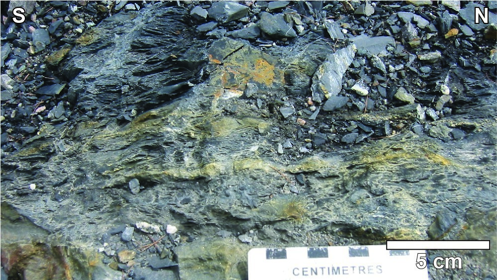
Facies 2 consists of finely bedded volcaniclastic rocks. This facies is characterized by decimatric to metric, light-grey to dark-grey sorted beds with parallel, oblique and crossbedded laminations, as well as convoluted beds typical of the lower portion of a Bouma sequence (Ta-Tb-Tc-Td). The coarser parts of debris flows are composed of subangular to rounded fragments of medium-grey to beige intermediate to felsic volcanic rocks. Larger fragments commonly have a lighter rim that could indicate a high temperature of emplacement.

Facies 3 consists of wacke, arkose, volcanogenic conglomerate and coarse volcaniclastic rocks. In the Marianne Lake area and Road 167 road-cut outcrop west of Cummings Lake, arkoses and, more locally, volcanogenic conglomerates form decimetric beds. Some of these beds are sorted with a finer-grained upper section of siltstone. In the Roy Township’s NW quarter and in the Blondeau Lake area (sheet 32G16-200-0202), Duquette (1964) noted the presence of thick lenses of unsorted volcanogenic conglomerates similar to conglomerates observed in the Cummings Lake Road 167 road-cut outcrop. Stones and cobbles consist of porphyritic rhyolite, sandstone and siltstone in a grey, sandy matrix.

Facies 4 groups turbidites consisting of alternating millimetric to decimetric beds of volcanogenic arkose, siltstone and mudstone. In the Cummings Lake cross-section, these turbidites have oblique or parallel laminations, current wrinkles and convolute beds. Stratification is affected by synsedimentary folds and faults. Beige to white siltstone beds are dismembered and folded inside rusted black mudstone layers that also show dysharmonic folds, suggesting an unstable depositional environment.
Facies 5 consists of pumiceous tuffs, interpreted as plinian fallouts, volcanogenic arkoses and smaller amounts of graphitic ash tuffs. This massive yellowish-white patina unit forms centimetric to decimetric beds with multiple normal to reverse sorting that indicate continuous, but pulsating eruptive activity (Lefebvre, 1991).
Facies 6 is a unit of siltstone, mudstone and ash tuff. This unit outcrops particularly well along Road 167 in the Cummings Lake cross-section, as well as on type locality outcrops on the north side of the Chibougamau Syncline. It consists of centimetric to millimetric, dark-grey to black graphite-rich beds, and locally contains beds of euhedral, nodular or framboidal pyrite. This facies has also been recognized over an E-W distance of more than 2 km NW of Dolomieu Lake (sheet 32G14-200-0102) as discontinuous lenses a few tens of metres thick located in contact with gabbroic sills (I3Ac).
The area between Cooke Mine and Laura Lake (sheet 32G15-200-0102) is characterized by massive flows of grey rhyolite and rhyodacite containing up to 5% plagioclase phenocrysts, interstratified with volcaniclastic rocks (Morin, 1994). These felsic rocks were not recognized by Lefebvre (1991) in the Chibougamau area.
The detailed study of the facies characterizing the Blondeau Formation was made possible through stratigraphic drilling carried out in 1979 by the Ministère in the Barlow Lake area NE of Chapais (sheet 32G15-200-0202; Morin et al., 1996). The different facies recognized by Archer (1983) during the analysis of drill core correspond to those defined by Lefebvre (1991) in the Marianne Lake area north of Chibougamau. These correlations are illustrated in the table below.
| Facies recognized by Archer (1983) in the Barlow Lake area, NE of Chapais (sheet 32G15-200-0202) | Facies of Lefebvre (1991) in the Marianne Lake area, NE of Chibougamau |
| Two volcaniclastic flows dominated by felsic fragments, the first with a zone of pyrite nodules accumulation and shale and silt intraclasts |
Facies 1 (rhyolitic breccia, massive sulphide lenses, coarse debris flows) Facies 2 (volcaniclastic rocks finely bedded) |
| Volcanogenic and intraclastic sedimentary rocks | Facies 3 (wacke, siltstone, conglomerate) |
| Mixed sedimentary rocks and black shale | Facies 4 (turbidites) |
| – | Facies 5 (pumiceous tuff, volcanogenic arkose, ash tuff) |
| Fine-grained sedimentary rocks (shale and green silt, grey shale, black shale) | Facies 6 (siltstone, mudstone and ash tuff) |
Blondeau Formation 1 (nAbl1): Basalt and Andesitic Basalt
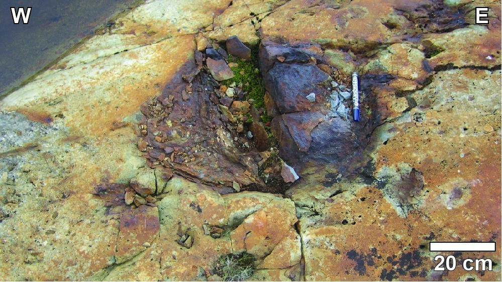
The basal part of the unit, in close proximity to contact with mafic volcanic rocks of the Bruneau Formation, is characterized by the presence of basalt and andesitic basalt, which commonly have a variolitic texture. These massive, pillowed and brecciated basalts form unit nAbl1. Light green, they typically contain 1 to 40% millimetric to centimetric varioles. Variolitic lavas have been recognized at several locations including: (a) east of Marianne Lake (sheet 32G16-200-0202); (b) at the base of the reference section exposed on the side of Road 167, along a NE-oriented segment between Cummings Lake and the northern boundary of sheet 32G16 (Duquette, 1970); (c) northeast of Roberge Lake on the UMA Property mineralized stripping (sheet 32H13-200-0201); (d) on an outcrop south of Philippon Lake (sheet 32G15-200-0202); and (e) along Road 113, near the western exit of the town of Chapais (sheet 32G15-200-0101). Unit nAbl1 also has a series of shallow flows (<2 m) of massive, pillowed and brecciated basalt without variolitic texture. In cross-section, the long axis of pillows is 30 to 40 cm in diameter. Higher in the unit, pillows contain vesicles and amygdules evenly distributed throughout the rock (up to 2%). Breccia fragments (up to 15 cm in diameter) are distinguished from the darker chloritic matrix by their beige to light green colour.
Blondeau Formation 2 (nAbl2): Andesite, Amygdaloidal Basalt and Volcaniclastic Rocks
Unit nAbl2 has been identified in the la Trêve Lake area. Here, the rocks consist mainly of volcaniclastic rocks of andesitic composition and calc-alkaline magmatic affinity (Daoudene and Beaudette, 2021). They are variably deformed due to the proximity of the shear zone that marks the contact between the volcanic rocks of the Roy Group and the sedimentary rocks of the Opémiska Group. Despite the deformation, primary structures are preserved. Quartz and feldspar crystals as well as lithic fragments showing a laminar flow banding structure are common in the rhyolitic rocks (outcrop 2021-YD-2082). Fragments range from 1 cm to 20 cm in length and 1 mm to 5 mm in thickness. The proportion of fragments can locally represent up to 10% of the volume of the rock. The proportion of crystals varies across the outcrop, which may reflect the presence of a primary bedding (outcrops 2021-MB-3095 and 2021-MB-3055).
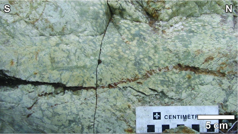
Polygenic lapilli tuff is present at the edge of the la Trêve Lake. The rock contains two main types of fragments of presumed volcanic origin. The first is aphanitic and whitish grey; the second contains ~30% plagioclase phenocrysts surrounded by chlorite. In total, the lapilli represent 25-30% of the volume of the rock and range in size from 1 to 5 cm in length and 2 mm to 2 cm in thickness. Fragments of massive sulphides (mainly pyrite) are also present, but their proportion does not represent more than 1% of the volume of the rock. The matrix around the lapilli is rich in chlorite and contains 2 to 3% of disseminated millimetre-sized pyrite. Drill cores (80-DAN-D-3, D-4, D-5 and F-1) in this area also show the presence of fine, banded and locally cherty tuff containing 5-10% pyrite and millimetre-sized pyrrhotite grains (Beauregard et al., 1980; Cornet and Girard, 1981).
In thin section, the volcaniclastic rocks show a microlithic texture with ~40% plagioclase crystals. The crystals are tabular and generally fresh, although locally some are sericitized. They are surrounded by a very fine-grained matrix composed mainly of plagioclase (40-50%) and quartz (5-10%). Trace minerals present are white mica, greenish biotite, epidote, chlorite, sphene and apatite (outcrops 2021-YD-2118 and 2021-YD-2119). Locally, porphyritic millimetre-sized fragments are observed and represent ~30% of the rock (outcrop 2021-YD-2116).
Drill core descriptions (80-DAN-D-3 and 80-DAN-D-5) from the la Trêve Lake area also indicate the presence of andesite and amygdaloidal basalt. The amygdules are filled with calcite and the rocks have carbonate veinlets (Beauregard et al., 1980; Cornet and Girard, 1981).
Geophysical Characteristics
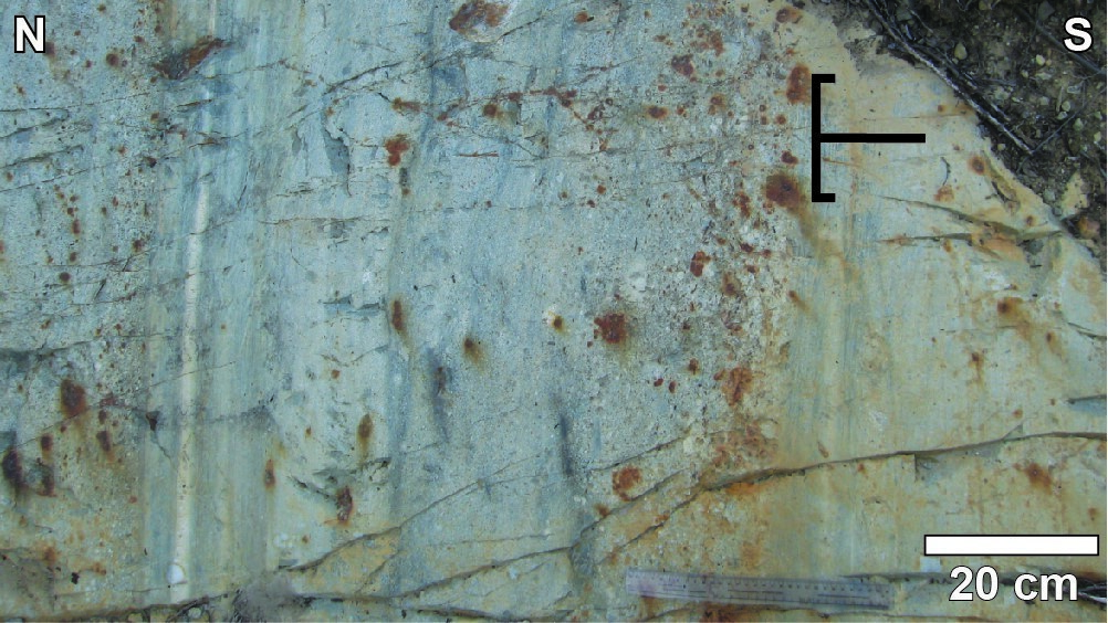
In the la Trêve Lake area, the rock level representing the Blondeau Formation is characterized on the aeromagnetic map by low magnetic susceptibility and the absence of textural variations. Electromagnetic anomalies appear to be absent.
Thickness and Distribution
The Blondeau Formation mainly outcrops along the Chibougamau Syncline axis, where its thickness is estimated to be approximately 1000 m (Duquette, 1982; Daigneault and Allard, 1990). The Blondeau Formation also appears on the western edge of the France Pluton in the Waconichi Tectonic Zone (sheet 32I04-200-0101). It is found on the sides of the Waconichi Syncline, on both sides of the Chebistuan Formation’s sedimentary rock unit. Within this synclinal structure, rocks of the Blondeau Formation also outcrop along second-order E-W anticlinal structures. To the SE of Chibougamau Lake (Dollier Lake area, sheets 32G09-200-0202 and 32G16-200-0102), in the Chapais Syncline, rocks of the Blondeau Formation outcrop over a thickness of ~500 m (Daigneault, 1986).
Dating

At Marianne Lake (sheet 32G16-200-0202), peperitic textures indicate that sedimentary rocks of the Blondeau Formation were not yet consolidated during intrusion of the Roberge Sill, which is the basal unit of the Cummings Intrusive Suite (Lefebvre, 1991). The emplacement of these two units can therefore be considered synchronous. This field relationship is confirmed by the maximum sedimentation age of an arkosic arenite of the Blondeau Formation (<2721 ±3 Ma; Leclerc et al., 2012), similar to the crystallization age of a quartz ferrodiorite of the Bourbeau Sill (2716.7 +1.0/-0.4 Ma; Mortensen, 1993).
| Isotopic System | Mineral | Maximum Sedimentation Age (Ma) | (+) | (-) | Reference(s) |
| U-Pb | Zircon | <2721 | 3 | 3 | Leclerc et al., 2012 |
Stratigraphic Relationship(s)
The basal contact of the Blondeau Formation with massive, pillowed and brecciated mafic flows of the Bruneau Formation is characterized by the appearance of variolitic basalts. Elsewhere, contact between the Bruneau and Blondeau formations is generally hidden by ultramafic to mafic intrusions of the Cummings Intrusive Suite.
In the Chapais Syncline (sheets 32G09-200-0202, 32G15-200-0101 and 32G16-200-0102), the upper contact of the Blondeau Formation with sedimentary rocks of the Haüy Formation (Opémisca Group) is represented by an erosional discordance. In the Dollier Lake area (sheet 32G09-200-0202), the discordance between the Blondeau and Haüy formations is obliterated by the Kapunapotagen Shear Zone (Daigneault, 1986). East of Waconichi Lake (sheet 32J01), the small-lapilli grey tuff of the Blondeau Formation is interstratified with a grey-green arenite of the Bordeleau Formation (Caty, 1978; Moisan, 1992).
West of Chapais (sheet 32G14), rocks of the Blondeau Formation form three strips: the South Kapunapotagen Strip, the Sunset Lake Strip and the Chaleur Lake Strip. The South Kapunapotagen Strip forms a lenticular unit limited by the Kapunapotagen Shear Zone, to the north, and the Lac des Misérables Shear Zone, to the south. It is cut to the west by the Lamarck Shear Zone.
The Sunset Lake Strip is also restricted to the west by the Lamarck Shear Zone and extends eastward to the north of Chapais. These rocks are located on the south side of the Chibougamau Anticline and have a polarity to the south. To the east of Deux Orignaux Lake (western part of sheet 32G14-200-0202), the basal contact with rocks of the Bruneau Formation is hidden by the intrusion of kilometre-thick gabbroic sills. West of Armada Lake (NE part of sheet 32G14-200-0102), the mafic to intermediate lapilli and block tuff at the base of the Blondeau Formation (nAbl) is in sharp contact with mafic volcanic rocks at the top of the Bruneau Formation (nAbnu1). The area west of Deux Orignaux Lake (sheet 32G14-200-0201) does not outcrop and the rocks exposed on the islands do not allow direct observation of the base of the Blondeau Formation. Since they directly overlie on rocks of the Deux Orignaux Member (Waconichi Formation), the most plausible hypothesis seems to imply a structural contact between these two units. The Blondeau Formation’s sommital contact with the base of the overlying Scorpion Formation is sharp and characterized by an E-W deformation zone dominated by flattening.
The Chaleur Lake Strip, <500 m wide, extends from the south of the lake of the same name to the east of the Chibougamau River (NE of sheet 32G14-200-0202). In this area, rocks of the Blondeau Formation are in sharp contact with underlying units of the Bruneau Formation. The sommital part is cut by an E-W shear zone that obliterates the discordance between volcaniclastic rocks of the Blondeau Formation (Roy Group) and sedimentary rocks of the Stella Formation (Opémisca Group; Durocher, 1979).
The la Trêve Lake band is between 500 m and 2 km wide. It extends over ~12 km through Geneviève Bay of the la Trêve Lake and through Gisèle Lake. The rocks are in contact, to the north, with volcanic rocks of the Bruneau Formation. The nature of the contact has not been observed in the field. To the south, the rocks of the la Trêve Lake band are in faulted contact with sedimentary rocks of the Opémiska Group (Daoudene and Beaudette, 2021).
Paleontology
Does not apply.
References
Publications available through SIGÉOM Examine
BEAUREGARD, A. J., DUQUETTE, A., KHOBZI, A., 1980. LOG DE SONDAGE CAROTTE. SEREM LTEE, rapport statutaire soumis au gouvernement du Québec; GM 36887, 71 pages, 4 plans.
CATY, J. L., 1978. Rapport intérimaire, canton de Richardson, comté d’Abitibi-Est. MRN; DP 606, 38 pages, 1 plan.
CORNET, A., GIRARD, P., 1981. Rapport final d’exécution, entente Gouvernement du Québec – SEREM F de mars 1980, projet Nord-Ouest québécois. SEREM LTEE, rapport statutaire soumis au gouvernement du Québec; GM 49689, 188 pages, 2 plans.
DAIGNEAULT, R., 1986. GEOLOGIE DE LA PARTIE NORD-EST DU CANTON DE DOLLIER – REGION DE CHIBOUGAMAU. MRN; DV 85-19, 1 plan.
DAIGNEAULT, R., ALLARD, G. O., 1990. LE COMPLEXE DU LAC DORE ET SON ENVIRONNEMENT GEOLOGIQUE – REGION DE CHIBOUGAMAU – SOUS-PROVINCE DE L’ABITIBI. IREM-MERI; MM 89-03, 290 pages.
DAOUDENE, Y., BEAUDETTE, M., 2021. Géologie de la région du lac la Trêve, Sous-province d’Abitibi, Eeyou Istchee Baie-James, Québec, Canada. MERN; BG 2022-04, 1 plan.
DUQUETTE, G., 1964. GEOLOGIE SUR LE QUART NORD-OUEST DU CANTON DE ROY, COMTE D’ABITIBI-EST. MRN; RP 513, 25 pages, 1 plan.
DUQUETTE, G., 1970. Stratigraphie de l’Archéen et relations métallogénies dans la région de Chibougamau. MRN; ES 008, 25 pages, 1 plan.
DUQUETTE, G., 1982. DEMIE NORD DES CANTONS DE MCKENZIE ET DE ROY ET QUART NORD-OUEST DU CANTON DE MCCORKILL – RAPPORT FINAL. MRN; DPV 837, 80 pages, 4 plans.
DUROCHER, M., 1979. CANTON D’OPEMISCA ET QUART NORD-OUEST DU CANTON DE CUVIER – RAPPORT INTERIMAIRE. MRN; DP 611, 34 pages, 1 plan.
MORIN, R., 1994. GEOLOGIE ET COMPILATION GEOLOGIQUE DE LA REGION DE CHAPAIS. MRN; MM 91-02, 66 pages, 6 plans.
MORIN, R., GOBEIL, A., GENEST, R., 1996. FORAGES STRATIGRAPHIQUES. MINISTERE DES RESSOURCES NATURELLES, rapport statutaire soumis au gouvernement du Québec; GM 53861, 70 pages, 1 plan.
Other publications
ARCHER, P., 1983. Interprétation de l’environnement volcano-sédimentaire de la Formation de Blondeau dans la section stratigraphique du lac Barlow, Chibougamau. Université du Québec à Chicoutimi, thèse de maîtrise, 199 pages, 6 plans. constellation.uqac.ca/1800
LECLERC, F., HARRIS, L.B., BÉDARD, J.H., VAN BREEMEN, O., GOULET, N., 2012. Structural and stratigraphic controls on magmatic, volcanogenic and syn-tectonic mineralization in the Chapais-Chibougamau mining camp, northeastern Abitibi, Canada. Economic Geology; volume 107, pages 963-989. dx.doi.org/10.2113/econgeo.107.5.963
LEFEBVRE, C., 1991. Étude de la genèse des pépérites et de leur contexte volcano-sédimentaire, Formation de Blondeau, Chibougamau, Québec. Université du Québec à Chicoutimi; mémoire de maîtrise, 215 pages. constellation.uqac.ca/1518
MOISAN, A., 1992. Pétrochimie des grès de la Formation de Bordeleau. Université du Québec à Chicoutimi; mémoire de maîtrise, 121 pages. constellation.uqac.ca/1457
MORTENSEN, J.K.,1993. U-Pb geochronology of the eastern Abitibi subprovince. Part 1: Chibougamau – Matagami – Joutel region. Canadian Journal of Earth Sciences; volume 30, pages 11-28. doi.org/10.1139/e93-002
Suggested Citation
Ministère de l’Énergie et des Ressources naturelles (MERN). Blondeau Formation. Quebec Stratigraphic Lexicon. https://gq.mines.gouv.qc.ca/lexique-stratigraphique/province-du-superieur/formation-de-blondeau_en [accessed on Day Month Year].
Contributors
|
First publication |
François Leclerc, P. Geo., Ph.D. francois.leclerc@mern.gouv.qc.ca (redaction) Mehdi A. Guemache, P. Geo., Ph.D. (coordination); Claude Dion, Eng., M.Sc. (critical review); Simon Auclair, P. Geo., M.Sc. (editing); Céline Dupuis, P. Geo., Ph.D. (English version); Nathalie Bouchard and Ricardo Escobar Moran (HTML editing). |
|
Revision(s) |
Mélanie Beaudette, P. Geo., M.Sc. melanie.beaudette@mern.gouv.qc.ca; Yannick Daoudene, P. Geo., Ph.D. yannick.daoudene@mern.gouv.qc.ca (redaction) Mehdi A. Guemache, P. Geo., Ph.D. (coordination); James Moorhead, P. Geo., M.Sc. (critical review); Simon Auclair, P. Geo., M.Sc. (editing); Dominique Richard, GIT, Ph.D. (English version). |