


Last modified:
Translation of original French
nApor1 Algoma-type iron formation (dominant carbonate-siderite and magnetite facies)
| Author: | Henry and Allard, 1979 |
| Age: | Neoarchean |
| Reference section: | No official stratotype, but Westminer Canada’s early 1990s stripping on Portage Island (UTM NAD 83, zone 18: 557539 mE, 5529521 mN) is a reference section. |
| Type area: | Area between southern Petit Gilman Lake and Portage Island, north of Dorés Lake (northern portion of NTS sheet 32G16) |
| Geological province: | Superior Province |
| Geological subdivision: | Abitibi Subprovince |
| Lithology: | Iron formation and volcaniclastic rock |
| Type: | Lithostratigraphic |
| Rank: | Member |
| Status: | Formal |
| Use: | Active |
- Roy Group
-
- Bordeleau Formation
- Ruisseau Dalime Formation
- Scorpion Formation
- Phooey Member
- Blondeau Formation
- Bruneau Formation
- Waconichi Formation
- Allard Member
- Scott Member
- Deux Orignaux Member
- Winchester Member
- Lemoine Member
- Portage Member
- Lacs Member
- Îles Member
- Coyote Member
- Chevrier Member
- Queylus Member
- Andy Member
- Obatogamau Formation
- Pichamobi Member
- Wachigabau Member
- David Member
Background
The Portage Member essentially consists of the Sauvage Lake iron formation described in detail by Henry and Allard (1979). It was informally included as a facies in the Waconichi Formation by Daigneault and Allard (1990). The mapping made by Roy et al. (2007) and the stratigraphic revision of the Roy Group (Leclerc et al., 2011) justify formal naming of the facies identified by Daigneault and Allard (1990), which became members within the Waconichi Formation.
Description
Portage Member 1 (nApor1): Algoma-Type Iron Formation (Dominant Carbonate-Siderite and Magnetite Facies)
The Sauvage Lake iron formation as described by Henry and Allard (1979) corresponds to an Algoma-type iron formation based on the Gross classification (1996). Three facies are recognized: (a) carbonate facies, (b) oxide facies, and (c) sulphide facies.
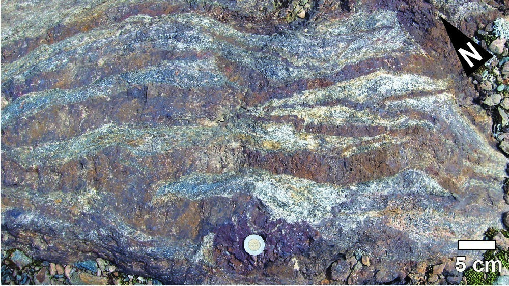
a) Carbonate Facies: This is the dominant facies, characterized by an ankerite-chlorite ± chloritoid schist containing pyrite layering. This rock is usually interbedded with a tuffaceous chert. This facies outcrops in the Sidérite Hill area, north of Surprenant Lake.
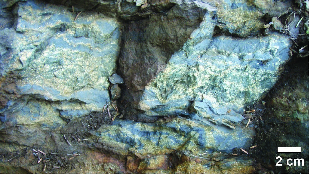
b) Oxide Facies: Recognized west of the Sidérite Hill and in the Portage Island area, it is characterized by a low-thickness (0.6 m) and discontinuous (up to 9 m lateral extension) magnetite iron formation (90-95% magnetite and 5-10% chert).
c) Sulphide Facies: This is the predominant facies in the Portage Island area. It consists of a dominant pyrite phase (pyrrhotite in the Mount Sorcier area) and an iron carbonate-chlorite-quartz-chloritoid assemblage. Traces of sphalerite and chalcopyrite are also present.
Portage Member 2 (nApor2): Intermediate to Felsic Volcaniclastic Rock
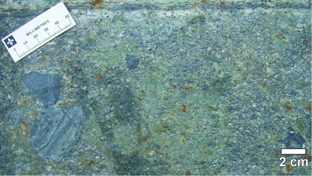
East of Alasper Lake, and south of the town of Chibougamau, the Sauvage Lake iron formation is interstratified with medium to coarse-lapilli tuff of intermediate to felsic composition. The matrix is composed of quartz and plagioclase phenocrystals. It contains millimetric to decimetric fragments of mafic volcanic rock and iron formation (oxide facies).
Leclerc et al. (2008) provide a description of Westminer Canada’s early 1990s reference stripping on Portage Island: “Stripping is located on the north side of a small anticline that locally shifts the polarities to the north. The southern portion of the stripping, which forms the base of the section, is characterized by a coarse-grained lapilli tuff, foliated with a pyritic matrix. Sericitized beige lapillis suggest an intermediate composition. Lapilli tuff is overlaid by a pyritic chert unit. Chloritized and sericitized mafic lava with millimetre pyrite layers occupy the northern portion of the stripping. Approximately 30 m to the SW, a banded iron formation with magnetite (55%), chlorite (30%), pyrite (15%) and traces of chalcopyrite, is hosted in a zone of foliated, magnetic and highly chloritized mafic lavas. E-W-oriented foliation and isoclinal folds are associated with regional deformation and cut by open folds and N-S oriented shear zones (fragile-ductile).”
Thickness and Distribution
The rocks of the Portage Member form lenses that are <70 m thick and have a maximum lateral extension of 2.4 km. They appear within the Lac Sauvage Shear Zone, between the southern Sauvage Lake area and Portage Island (northern portion of NTS sheet 32G16).
Dating
None.
Stratigraphic Relationship(s)
The Portage Island stripping described in the “reference section” indicates that iron formations are hosted in “a zone of foliated, magnetic and highly chloritized mafic lava” attributed to the David Member (upper part of the Obatogamau Formation) north of Chibougamau Lake.
Paleontology
Does not apply.
References
| Author(s) | Title | Year of Publication | Hyperlink (EXAMINE or other) |
|---|---|---|---|
| DAIGNEAULT, R. – ALLARD, G.O. | Le Complexe du Lac Doré et son environnement géologique (région de Chibougamau – sous-province de l’Abitibi). MM89-03, Ministère de l’Énergie et des Ressources, Québec; MM 89-03, 275 pages. | 1990 | MM 89-03 |
| GROSS, G.A. | Gîtes stratiformes de fer. In: Géologie des types de gîtes minéraux du Canada (Eckstrand, O.R. — Sinclair, W.D. – Thorpe, R.I., éditeurs). Geological Survey of Canada, Geology of Canada Series no. 8, pages 47-61. | 1995 | Source |
| HENRY, R.L. – ALLARD, G.O. | Formation de fer du Lac Sauvage, cantons de McKenzie et de Roy, région de Chibougamau. Ministère de l’Énergie et des Ressources, Québec; DPV 593, 90 pages. | 1979 | DPV 593 |
| LECLERC, F. – BÉDARD, J.H. – HARRIS, L.B. – GOULET, N. – HOULE, P. – ROY, P. | Nouvelles subdivisions de la Formation de Gilman, Groupe de Roy, région de Chibougamau, sous-province de l’Abitibi, Québec, résultats préliminaires. Current Researches, 2008-07, Geological Survey of Canada; 23 pages. | 2008 | Source |
| LECLERC, F. – BÉDARD, J.H. – HARRIS, L.B. – McNICOLL, V.J. – GOULET, N. – ROY, P. – HOULE, P. | Tholeiitic to calc-alkaline cyclic volcanism in the Roy Group, Chibougamau area, Abitibi Greenstone Belt—Revised stratigraphy and implications for VHMS explorations. Canadian Journal of Earth Sciences; volume 48, pages 661-694. | 2011 | Source |
| ROY, P. – FALLARA, F. – HOULE, P. – CHENG, L.Z. – RABEAU, O. – BLAIS, A. – LAFRANCE, B. – LECLERC, F. – PILOTE, P. – RIVERIN, G. – SCHMITT, L. | Étude sur le flanc sud du Complexe du Lac Doré, veines Cu-Au et modèle 3D préliminaire. Abstracts of conferences and posters, Québec Exploration 2007, Ministère des Ressources naturelles et de la Faune, Québec; page 37. | 2007 | DV 2007-04 |