

Last modified: 23 May 2023
DISCLAIMER: This English version is translated from the original French. In case of any discrepancy, the French version shall prevail.
| Author(s): | Duquette, 1970 |
| Age: | Neoarchean |
| Stratotype: | Section along Road 167, west of Cummings Lake (Bédard et al., 2009) |
| Type area: | West of Cummings Lake (NTS sheet 32G16) |
| Geological province: | Superior Province |
| Geological subdivision: | Abitibi Subprovince |
| Lithology: | Mafic and ultramafic intrusive rocks |
| Category: | Lithodemic |
| Rank: | Lithodeme |
| Status: | Formal |
| Use: | Active |
- Cummings Intrusive Suite
- Bourbeau Sill
- Ventures Sill
- Roberge Sill
- Esturgeon Sill
Background
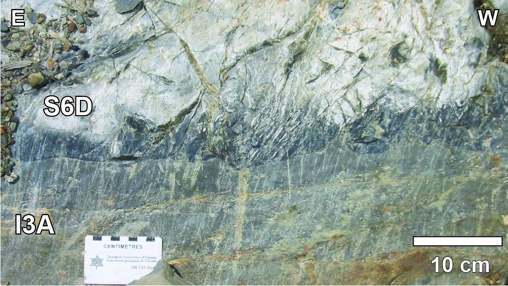
The Roberge Sill detailed stratigraphy was established by Duquette (1982) and refined by Poitras (1984) through drillings, east of Barlow Lake. It was reviewed by the study of the Cummings Lake road section (Bédard et al., 2009).
Description
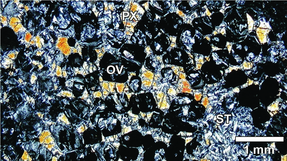
Stratigraphic drillings in the Barlow Lake area showed that this intrusion was inversely differentiated with an ultramafic zone at the top. This Roberge Sill stratigraphy consists first of a chilled margin zone in contact with the host rock, followed by a pyroxenite zone, and then of a rhythmic zone consisting of dunite, werhlite and clinopyroxenite, which are overlain by a dunite zone composed of serpentinized peridotite (Poitras, 1984). On the roadway section west of Cummings Lake, although dunites and peridotites are serpentinized, pseudomorphs of olivine cumulus crystals are still recognizable, except near fault zones where actinolite and tremolite appear. Pyroxenites also show preserved cumulate textures.
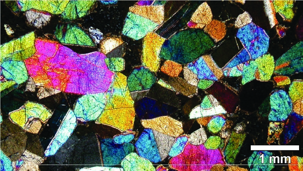
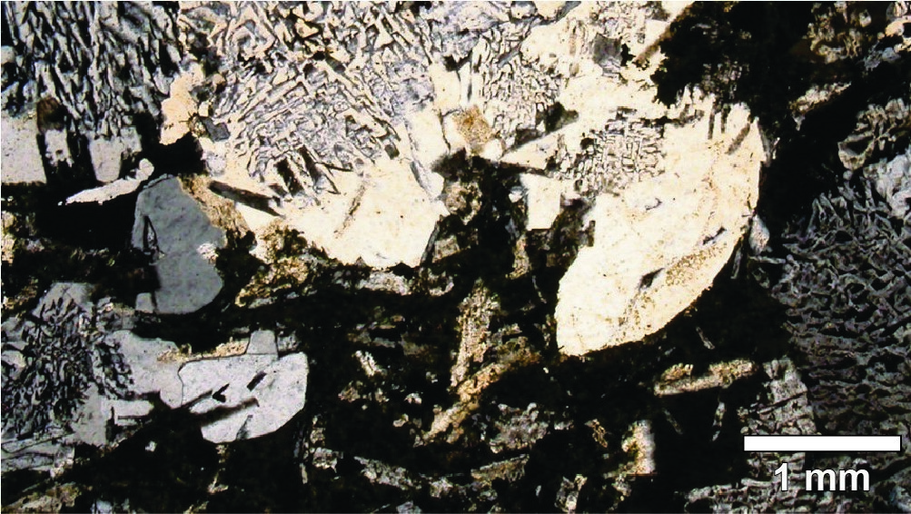
The portion of the roadway section exposing the lower part of the Cummings Intrusive Suite also includes several gabbroic units that have been included in the Roberge Sill. The Blondeau Formation’s siltstone, mudstone and ash tuf unit is cut by five intrusions of subophitic to ophitic gabbro and gabbronorite, as well as granophyric leucogabbro and ferrogabbro, ranging in thickness from 2 m to 90 m. As in the Geoff and Marianne lakes area, the presence of peperitic textures suggests that these gabbro intrusions were injected into unconsolidated sediments. Chilled margins are locally well preserved. Gabbro is light grey and usually very fine grained with a massive appearance. The thickest intrusion is a massive leucogabbro that reveals a granophyric texture when observed under the microscope. Quartz and plagioclase intergrowth make up 50 to 90% of this leucogabbro. Another intrusion of much coarser-grained greyish-green subophitic gabbro appears at the top of the Roberge Sill. Euhedral crystals of clinopyroxene (10-30%, 1-2 cm) form aggregates separated by zoned and altered plagioclase relics less than 2 mm in size.
Thickness and Distribution
The Roberge Sill, not exceeding 550 m thick, is known on both sides of the Chibougamau Anticline over a distance of more than 85 km (Duquette, 1982; Poitras, 1984).
Dating
None.
Stratigraphic Relationship(s)
Rocks of the Roberge Sill cut volcanic rocks of the Roy Group’s second volcano-sedimentary cycle and appear immediately below the Ventures Sill (Duquette, 1970, 1982).
Paleontology
Does not apply.
References
Publications available through SIGÉOM Examine
DUQUETTE, G., 1970. Stratigraphie de l’Archéen et relations métallogeniques dans la région de Chibougamau. MRN; ES 008, 25 pages, 1 plan.
DUQUETTE, G., 1982. DEMIE NORD DES CANTONS DE MCKENZIE ET DE ROY ET QUART NORD-OUEST DU CANTON DE MCCORKILL – RAPPORT FINAL. MRN; DPV 837, 80 pages, 4 plans.
Other publications
BÉDARD, J. H., LECLERC, F., HARRIS, L. B., GOULET, N. 2009. Intra-sill magmatic evolution in the Cummings Complex, Abitibi greenstone belt: Tholeiitic to calc-alkaline magmatism recorded in an Archaean subvolcanic conduit system. Lithos; volume 111, pages 47-71. https://doi.org/10.1016/j.lithos.2009.03.013
POITRAS, A. 1984. Caractérisation géochimique du Complexe de Cummings, région de Chibougamau-Chapais, Québec. Université du Québec à Montréal; mémoire de maîtrise, 159 pages.
Suggested Citation
Ministère des Ressources naturelles et des Forêts (MRNF). Roberge Sill. Quebec Stratigraphic Lexicon. gq.mines.gouv.qc.ca/lexique-stratigraphique/province-du-superieur/filon-couche-de-roberge_en [accessed on Day Month Year].
Contributors
|
First publication |
François Leclerc, P.Geo., Ph. D. françois.leclerc@mern.gouv.qc.ca (redaction) Mehdi A. Guemache, P.Geo., Ph. D. (coordination); Mélina Langevin, B. Sc. (critical review); Simon Auclair, P.Geo., M. Sc. (editing); Céline Dupuis, P.Geo., Ph. D. (English version); Yan Carette (HTML editing). |