

First published: 20 October 2016
Last modified: 29 January 2024
DISCLAIMER: This English version is translated from the original French. In case of any discrepancy, the French version shall prevail.
| Author: | Simard et al., 2013 |
| Age: | Archean; Paleoproterozoic |
| Stratotype: | None |
| Type area: | Kuujjuaq and Ungava Bay area ( NTS sheets 24J and 24K) |
| Geological province: | Churchill Province |
| Geological subdivision: | Baleine Lithotectonic Domain |
| Lithology: | Migmatitic rocks |
| Category: | Lithodemic |
| Rank: | Complex |
| Status: | Formal |
| Use: | Active |
None
Background
The Qurlutuq Complex is a unit of migmatitic rocks defined by Simard et al. (2013) in the Kuujjuaq and Ungava Bay area. It has been extended southward in the Saffray Lake (Lafrance et al., 2014) and Jeannin Lake (Charette et al., 2016) areas,and to the SE in the Henrietta Lake and Brisson Lake areas (Lafrance et al., 2015, 2016). Following division of the Southeastern Churchill Province into lithotectonic domains as part of a synthesis (Lafrance et al., 2018), the definition of the Qurlutuq Complex has been revised to include only those migmatites located within the Baleine Lithotectonic Domain (Lafrance et al., 2020). In the George and Falcoz lithotectonic domains, similar migmatitic rocks were assigned to the Guesnier and Fougeraye complexes, respectively. The Qurlutuq Complex used to have three informal units defined by Simard et al. (2013). Since the last two units were located exclusively in the George or Falcoz domains, they were reassigned to units mentioned above based on their location.
Description
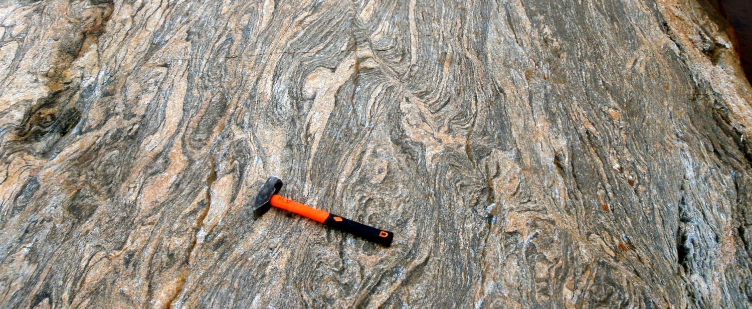
The Qurlutuq Complex consists of banded migmatitic rocks associated with areas of low to medium magnetic susceptibility.

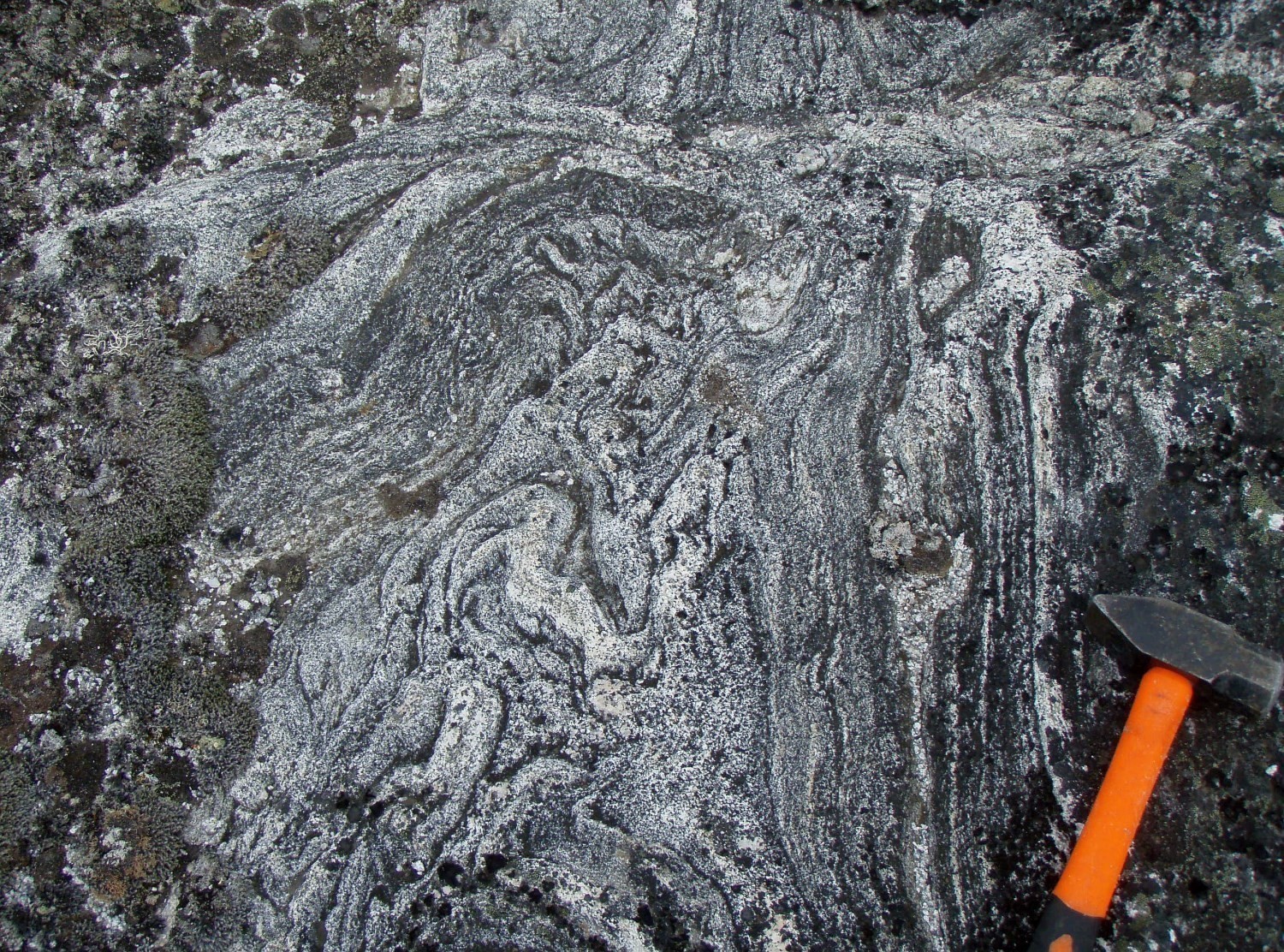
Qurlutuq Complex migmatitic rocks underwent significant partial melting involving the formation of 30-60% leucosome, which is mostly tonalitic, locally granitic, and whitish to light grey or rarely pink. Most of the migmatite layers are represented by stromatic metatexite. It displays a leucosome in the form of leucocratic centimetric bands oriented along foliation, undulating and commonly folded. Locally, there are interconnected layers of leucosome and net textures. Many outcrops contain a higher proportion of leucosome, making it difficult, if not impossible, to identify the protolith, especially when diatexite is present. Raft textures and schlieren are common.
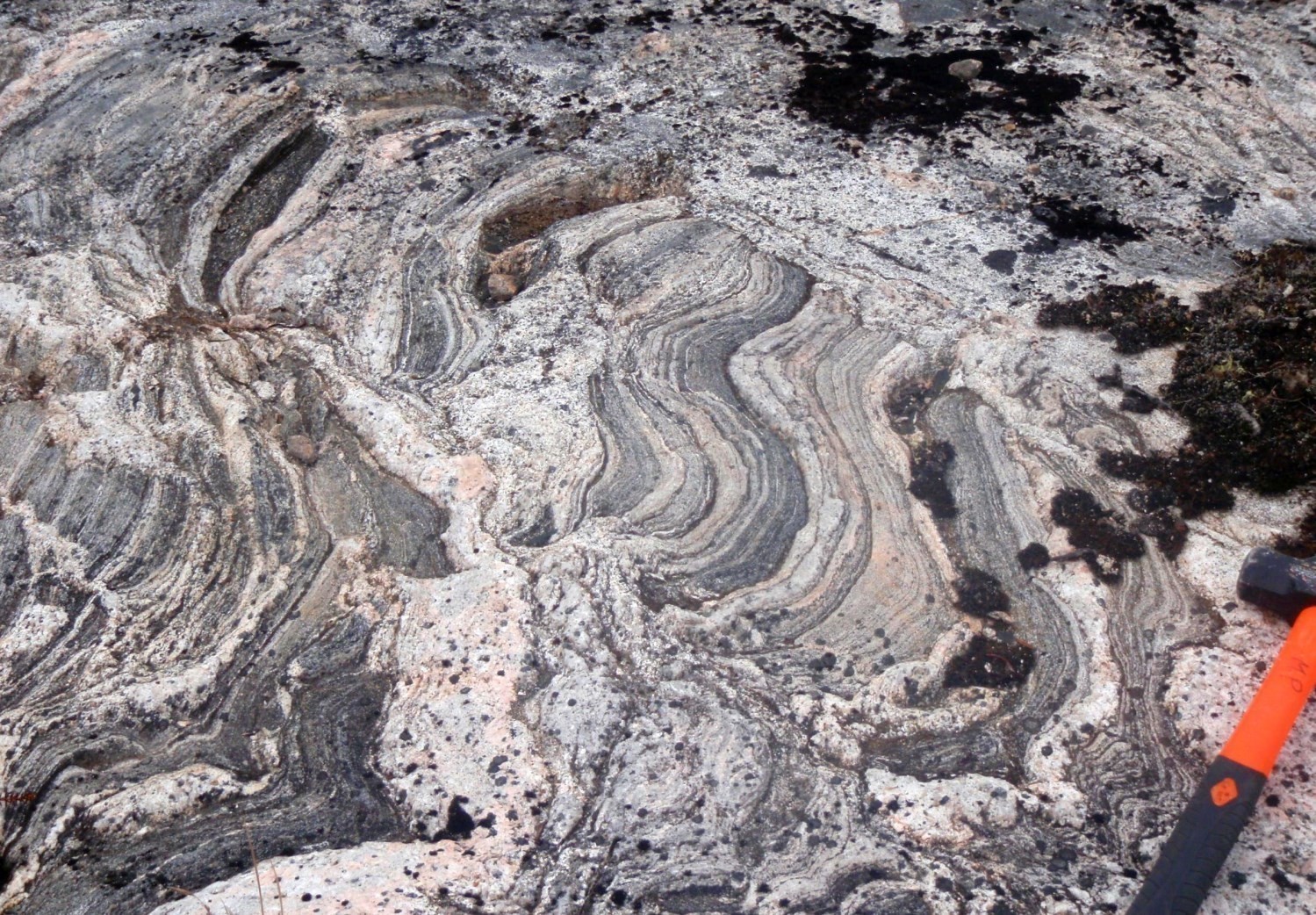
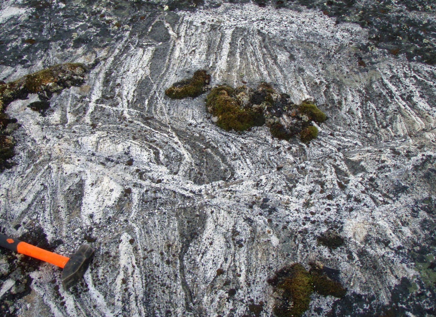
The diatexite contains many decimetre to metre-wide rafts consisting mainly of orthogneiss, similar to those of the Ungava Complex, diorite (Ralleau Suite) and paragneiss (False Suite) in lesser amounts. The neosome contains 5-20% biotite schlieren. In thin sections, grain size is variable and large grains of igneous origin alternate with finely recrystallized clusters or bands. Quartz form large anhedral zones with undulatory extinction (20-40% of the rock), while K-feldspar accounts for up to 30% of the rock. The schlieren also include a significant amount of accessory minerals that are, in order of importance, epidote, sphene, zircon, muscovite, hornblende, opaque minerals, apatite, chlorite, and allanite.
Thickness and distribution
The Qurlutuq Complex covers an area of 1992 km2 in the Baleine Lithotectonic Domain, mainly in the central part of the domain.
Dating
Archean ages between 2855 Ma and 2655 Ma (Augland et al., 2015) obtained for a migmatite sample are similar to those of the Ungava Complex gneiss (2843-2651 Ma). This supports the hypothesis that migmatites derive from partial melting of Archean gneiss. Data processing highlighted three modes at 2834 ±6 Ma, 2809 ±7 Ma and 2772 ±9 Ma. Augland et al. (2015) mentions that the best hypothesis is that the migmatite protolith was emplaced around 2834 Ma and then affected by a thermal event at ~2809 Ma. Although a Paleoproterozoic partial melting event (1.9-1.8 Ga) affecting migmatitic rocks of the Qurlutuq Complex cannot be excluded, analytical results indicate that this unit underwent ancient migmatization in the Archean. The Paleoproterozoic age is difficult to specify as it is represented by thin overgrowth that is difficult to analyze (John David, personal communication, 2019).
| Unit | Sample Number | Isotopic System | Mineral | Crystallization Age (Ma) | (+) | (-) | Metamorphic Age (Ma) | (+) | (-) | Reference(s) |
| ApPqur | 15-JC-5228A | U-Pb | Zircon | 2666 | 7 | 7 | Corrigan et McFarlane, personal communication, 2017 | |||
| 2655 | 7 | 7 | ||||||||
| ApPqur | 12-MS-036A | U-Pb | Zircon | 2834 | 6 | 6 |
2809 |
7 |
7 |
Augland et al., 2015 |
Stratigraphic Relationship(s)
Migmatitic rocks of the Qurlutuq Complex are spatially associated with gneiss of the Ungava Complex, which are in gradual contact and poorly defined. Banding of Qurlutuq Complex migmatitic rocks is irregular, undulating, discontinuous and generally chaotic, which distinguishes it from the more straight and regular banding of Ungava Complex gneiss. Qurlutuq Complex rocks occurs as enclaves and are intruded by the majority of Paleoproterozoic intrusive units of the Baleine Domain, especially rocks of the De Pas Supersuite and whitish intrusions of the Aveneau Suite. The latter resemble the leucosome of Qurlutuq Complex migmatites.
Paleontology
Does not apply.
References
Publications available through SIGÉOM Examine
AUGLAND, L.E., DAVID, J., PILOTE, P., LECLERC, F., GOUTIER, J., HAMMOUCHE, H., LAFRANCE, I., TALLA TAKAM, F., DESCHENES, P.-L., GUEMACHE, M.A., 2016. Datations U-Pb dans les provinces de Churchill et du Supérieur effectuées au GEOTOP en 2012-2013. MERN, GEOTOP; RP 2015-01, 43 pages.
CHARETTE, B., LAFRANCE, I., MATHIEU, G., 2016. Géologie de la région du lac Jeannin, Québec, Canada. MERN; BG 2015-01, 1 plan.
LAFRANCE, I., BANDYAYERA, D., BILODEAU, C., 2015. Géologie de la région du lac Henrietta (SNRC 24H). MERN; RG 2015-01, 62 pages, 1 plan.
LAFRANCE, I., BANDYAYERA, D., CHARETTE, B., BILODEAU, C., DAVID, J., 2016. GEOLOGIE DE LA REGION DU LAC BRISSON (SNRC 24A). MERN; RG 2015-05, 64 pages, 1 plan.
LAFRANCE, I., CHARETTE, B., VANIER, M.-A., 2018. Sud-est de la Province de Churchill, Nunavik, Québec, Canada: synthèse de la géologie. MERN; BG 2018-12
LAFRANCE, I., SIMARD, M., BANDYAYERA, D., 2014. Géologie de la région du lac Saffray (SNRC 24F, 24G). MRN; RG 2014-02, 51 pages, 1 plan.
LAFRANCE, I., VANIER, M.-A., CHARETTE, B., 2020. Domaine lithotectonique de Baleine, sud-est de la Province de Churchill, Québec, Canada: synthèse de la géologie. MERN; BG 2020-07, 4 plans.
SIMARD, M., LAFRANCE, I., HAMMOUCHE, H., LEGOUIX, C., 2013. GEOLOGIE DE LA REGION DE KUUJJUAQ ET DE LA BAIE D'UNGAVA (SNRC 24J, 24K). MRN; RG 2013-04, 62 pages, 1 plan.
Other publications
MACHADO, N., GOULET, N., GARIEPY, C., 1989. U-Pb geochronology of reactivated Archean basement and of Hudsonian Trough. Canadian Journal of Earth Sciences; volume 26, pages 1-15. https://doi.org/10.1139/e89-001
Suggested Citation
Ministère de l'Énergie et des Ressources naturelles (MERN). Qurlutuq Complex. Quebec Stratigraphic Lexicon. https://gq.mines.gouv.qc.ca/lexique-stratigraphique/province-de-churchill/complexe-de-qurlutuq_en [accessed on Day Month Year].
Contributors
|
First publication |
Isabelle Lafrance, P.Geo., M.Sc. isabelle.lafrance@mern.gouv.qc.ca (redaction) Mehdi A. Guemache, P.Geo., Ph.D. (coordination); Thomas Clark, P.Geo., Ph.D.; James Moorhead, P.Geo., Ph.D. (critical review); Claude Dion, Eng., M.Sc. (editing); Céline Dupuis, P.Geo., Ph.D. (English version). |
|
Revision(s) |
Isabelle Lafrance, P.Geo., M.Sc. isabelle.lafrance@mern.gouv.qc.ca (redaction; 06/08/2018) Mehdi A. Guemache, P.Geo., Ph.D. (coordination); Simon Auclair, P.Geo., M.Sc. (editing); Céline Dupuis, P.Geo., Ph.D. (English version); Nathalie Bouchard (HTML editing). |
5 février 2020