


Geology of the Dolbeau-Blondelas Area, Grenville Province, Saguenay–Lac-Saint-Jean Region, Quebec, Canada
Project for NTS sheets 32H01, 32H07
Mhamed El Bourki, Abdelali Moukhsil
BG 2022-02
Translated on 17 February 2026


The areas north of Dolbeau-Mistassini (NTS sheet 32H01), Girardville and Lake Blondelas (sheet 32H07), in the Saguenay–Lac-Saint-Jean region, were geologically mapped at a 1:50,000 scale in the summer of 2021. The rocks mapped are Mesoproterozoic to Neoproterozoic in age (1.484-0.958 Ga), and were emplaced in the Allochton of the Grenville Province. Located in the eastern part of sheet 32H01, the Lac-Saint-Jean Anorthositic Suite (1169-1135 Ma) is the unit with the largest surface area. Rocks in this suite are cut by rocks from other intrusions, such as the Écluse Batholith (granite, syenite, gabbronorite, leuconorite), the Rivière Noire Intrusion (ultramafic in composition and enriched in rare earth elements [REE] ± P), and the Sainte-Hedwidge Intrusive Suite (1017.6 ±36 Ma, granite, syenite, mangerite, gabbronorite). Other Mesoproterozoic intrusive rocks in the region include the Vertu, Grondin, Adélard and Festins plutonic suites, the Coin and Long batholiths, the Jean-Marie Intrusive Suite, and the Tommy Intrusive Suite. Supracrustal rocks have also been mapped in the area: the Saint-Onge Supracrustal Sequence (>1160 Ma, quartzofeldspathic paragneiss, marble containing ± wollastonite, calc-silicate rocks, quartzite, metavolcanic rocks) and the Barrois Complex (<1224 ±18 Ma, volcano-sedimentary rocks). The presence of granitic to syenitic pegmatite dykes and a few carbonatite dykes scattered around the region should also be mentioned. The Crevier Alkaline Intrusion (CAI) is Neoproterozoic in age (957.5 ±2.9 Ma) and is located in the northern part of sheet 32H07. It is composed of nepheline syenite, carbonatite and megacrystic dykes containing albite, nepheline and pyrochlore. Previous exploration works have demonstrated its economic interest in Nb-Ta.
Mesoproterozoic rocks are generally deformed and cut by several faults and shear zones. The regional structural grain is mainly oriented NE-SW and NW-SE, accommodating the final emplacement of intrusions. The NW-SE orientation is also related to the postorogenic emplacement of the CAI. The area is characterized by regional prograde metamorphism from the upper amphibolite facies to the granulite facies. The region hosts several mineralized zones that are prospective for mineral exploration:
1) REE ± Th mineralization in granitic dykes, syenitic and granitic alkali feldspar rocks and carbonatites;
2) Nb-Ta mineralization in alkaline intrusive rocks and carbonatites;
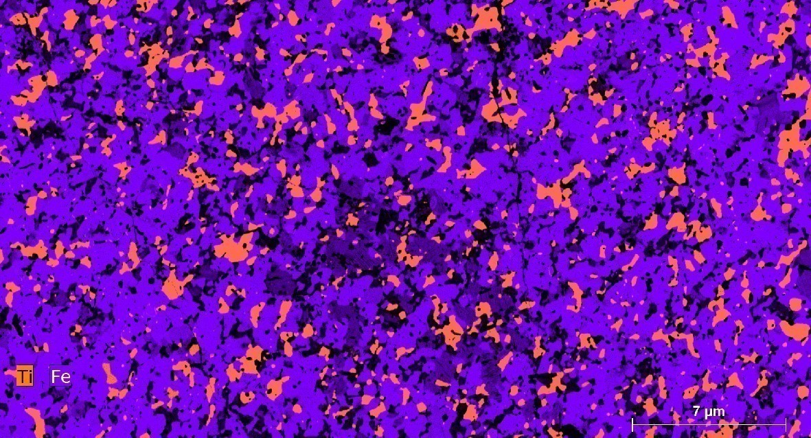
3) Fe-Ti ± P ± V mineralization in gabbronorite and nelsonite;
4) REE and P mineralization in ultramafic and syenitic rocks;
5) Ni-Cu mineralization in mafic and ultramafic rocks.
Methodology
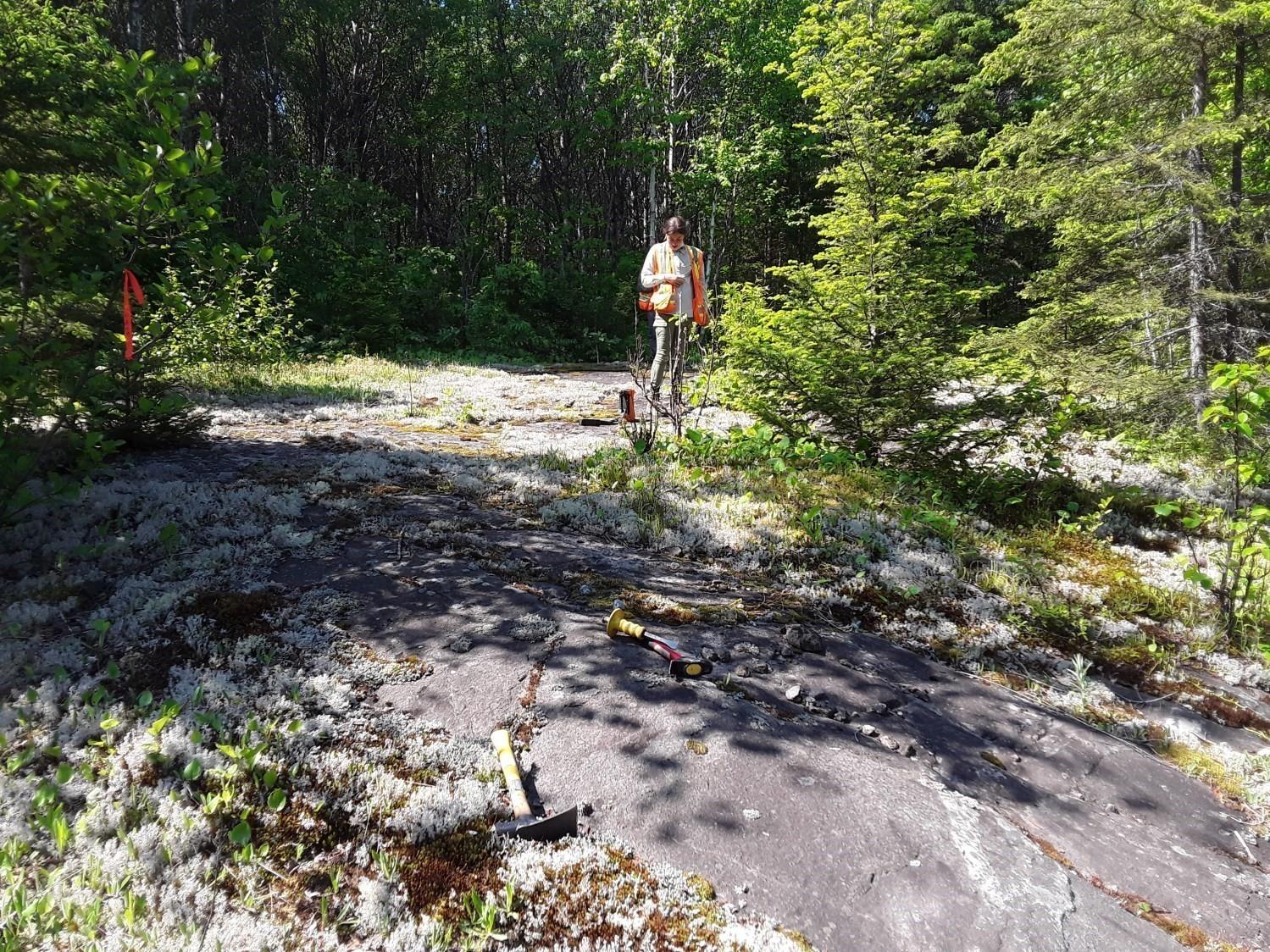
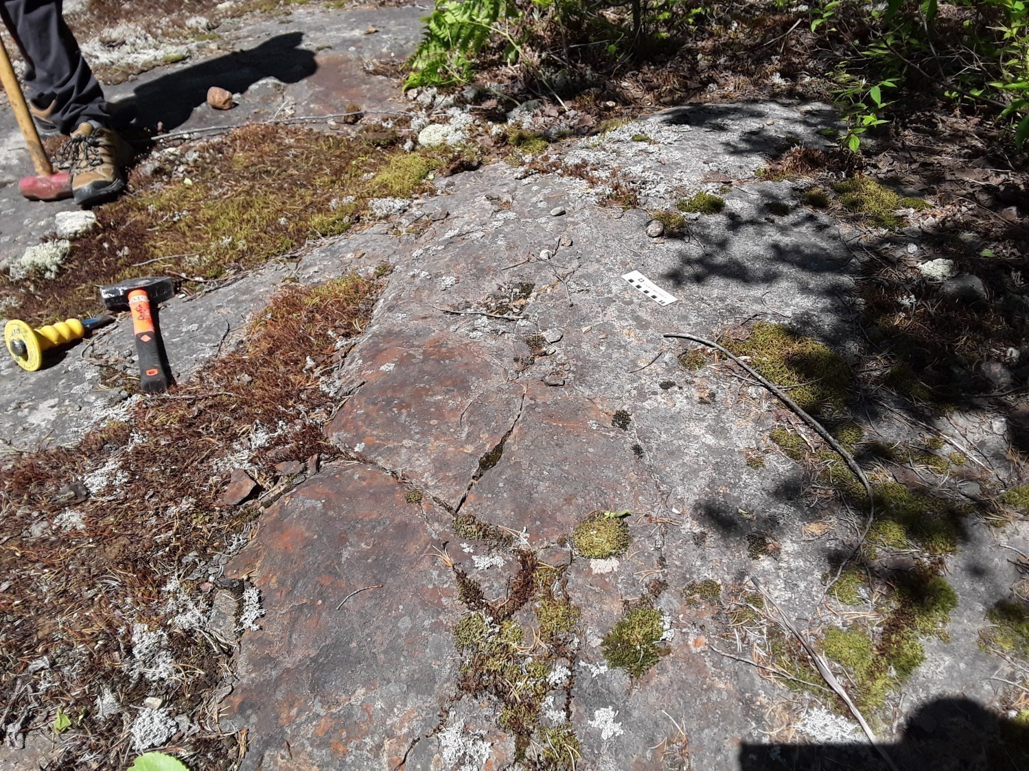
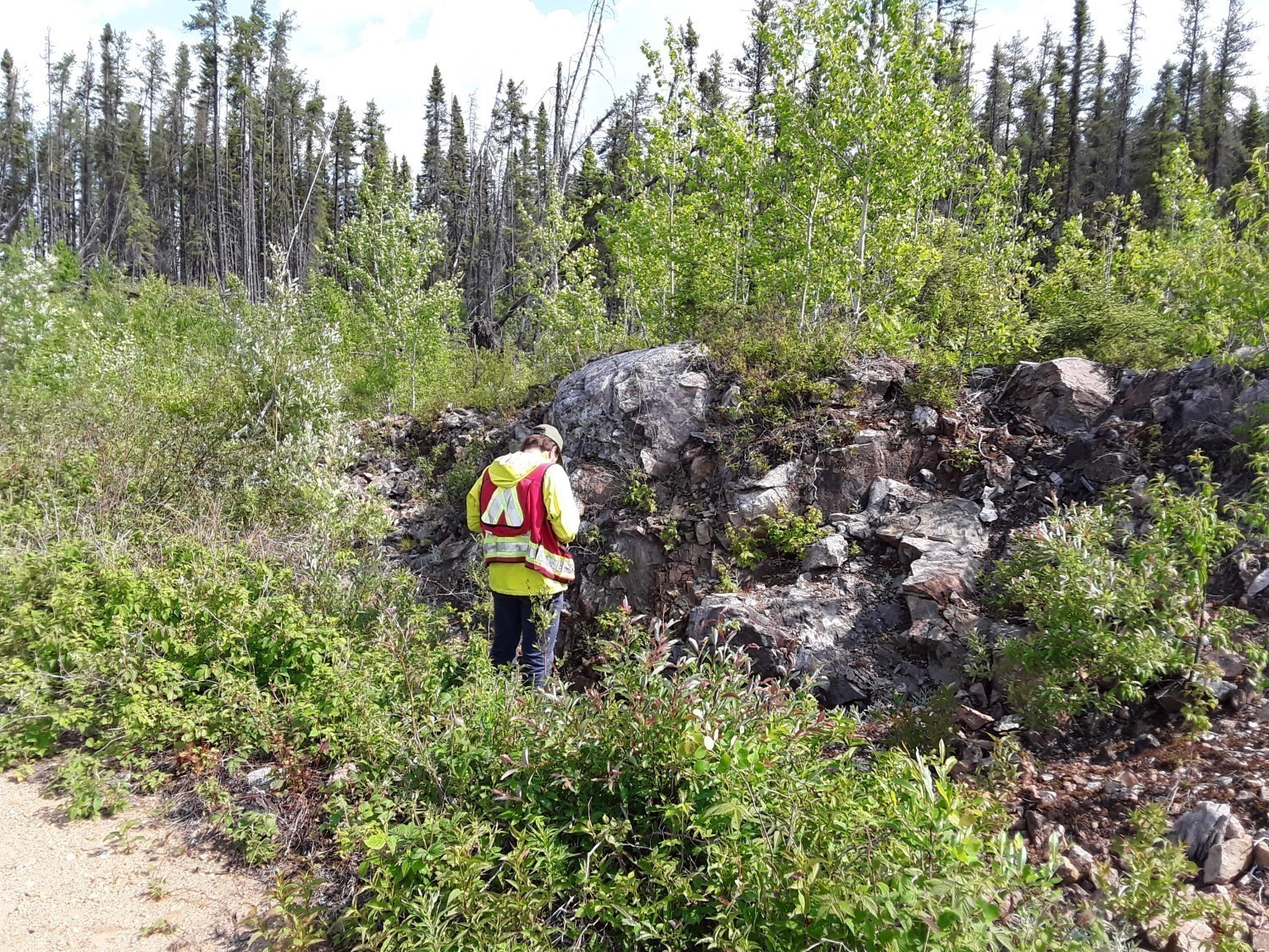
The area was mapped using the established method for surveys in forest areas served by a network of secondary roads. Geological mapping work was carried out by a team of three geologists, a geologist-in-training, a geological engineer and five students between May 28 and August 13, 2021. The geological mapping of the Dolbeau-Blondelas project produced and updated the information presented in the table opposite.
Field Laboratory
Measurements were taken both in fresh exposure and on the sawed face of rock samples continuously during the mapping project. The various measurements collected were density, magnetic susceptibility and systematic photography (see table opposite). Under the supervision of the geologist in charge, trained students took measurements on most of the main lithologies observed in outcrops and on some secondary lithologies deemed relevant, such as those of volcanic origin or mineralized. Physical property measurements were taken following the protocols established by Christian Dupuis (Université Laval), in particular those for magnetic susceptibility and density.
| Element | Number |
|---|---|
| Described outcrop (“geofiche”) | 1214 outcrops |
| Total lithogeochemical analysis | 142 samples |
| Lithogeochemical analysis of metals of economic interest | 70 samples |
| Geochronological analysis | 6 samples |
| Covered thin section | 115 |
| Polished thin section | 101 |
| Stratigraphic unit | 14 |
| Structural unit | 7 |
| Mineralized zone unit | 19 |
| Magnetic susceptibility measurement | 548 |
| Density measure | 517 |
| Sample photo | 1051 |
Previous Work
The table below lists the work that has been done in the study area since 1923. It also includes references cited in the report. An exhaustive list can be found in the EXAMINE documentary database.
| Author(s) | Type of Work | Contribution |
|---|---|---|
| Berkey, 1923 | Geological survey and mineral resources reconnaissance | First geological mapping of the Saguenay–Lac-Saint-Jean region |
| Ross, 1950 | Geological reconnaissance survey | Geological reconnaissance works, notably of anorthosites |
| Berrangé, 1962 | Mapping at scale 1:63,000 | Mapping works |
| Laurin and Sharma, 1975 | Mapping and geological reconnaissance at scale 1:250,000 | Mapping project spread over several years (1965 to 1967) |
| Prospecting and drilling surveys | Mapping, prospecting, stripping and drilling works in the Crevier mineralized zone | |
| Airborne magnetic survey of the western part of Lac-Saint-Jean | High-resolution geophysical coverage | |
| Geological survey of Quaternary deposits in the Girardville area (sheets 32H01, 32H02, 32H07 and 32H08) | Analysis of indicator minerals in glacial and glaciofluvial sediments | |
| Mapping of surface deposits in the Mistassini River area (sheets 32H01, 32H02, 32H07 and 32H08) |
Mineral potential assessment from a Quaternary geological survey |
|
| Study of the Nb-Ta mineralization in the Crevier Alkaline Intrusion | Petrographic, geochemical and metallogenic study of the Crevier mineralized zone |
Stratigraphy
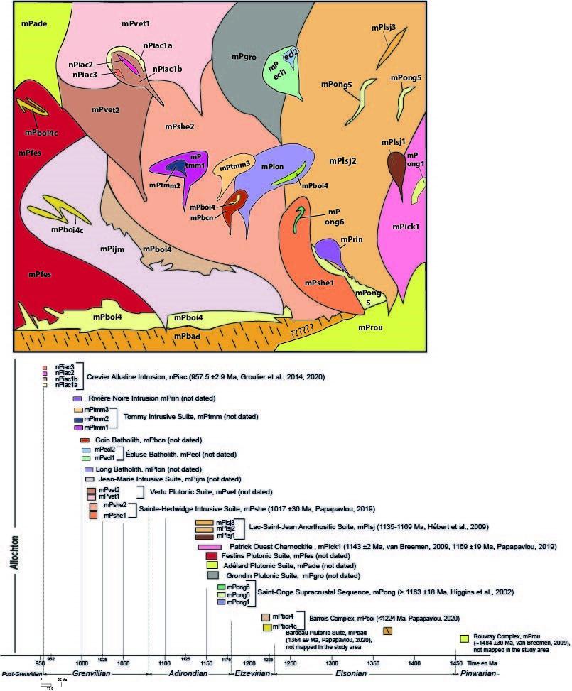
Mesoproterozoic Bedrock
Although the Rouvray Gneissic Complex (mProu, Hébert et al., 2009) and the Bardeau Plutonic Suite (mPbad, Moukhsil and Daoudene, 2019) do not outcrop in the mapped area, they may form its bedrock. The Rouvray Gneissic Complex mapped further NNE (sheet 22E07) has an estimated age of 1484 ±30 Ma (van Breemen, 2009). It consists mostly of granulitic orthogneiss with a charnockitic and mangeritic composition, diorite, and granitic or quartzofeldspathic gneiss (Hébert et al., 2009). The Bardeau Plutonic Suite outcrops mainly SW of the area (sheet 32A) and has an estimated age of 1364 ±9 Ma (Papapavlou, 2020).
Supracrustal Units
The two supracrustal units resting on this bedrock are the Barrois Complex (mPboi, <1224 Ma, Papapavlou, 2020) and the Saint-Onge Supracrustal Sequence (mPong, >1163 ±18 Ma, Higgins et al., 2002).
In the area mapped, the Barrois Complex takes the form of large rafts and enclaves within other lithologies. It consists of locally migmatized quartzofeldspathic gneiss containing biotite, quartzite, migmatite, and granitic gneiss (mPboi4). The mPboi4c subunit is made up of paragneiss containing biotite ± sillimanite ± garnet ± graphite, amphibolitized mafic volcanic rock, marble, calc-silicate rocks, garnetite and quartzite ± graphite ± garnet. Three units have been identified in the Saint-Onge Supracrustal Sequence (mPong). They are: 1) unit mPong1, consisting of a wollastonite skarn and host to the Saint-Onge deposit further north in the mapped area (sheet 22E04); 2) unit mPong5, consisting of quartzofeldspathic paragneiss with interbedded layers of quartzite, calc-silicate rocks and some marble; and 3) a new unit, mPong6, consisting of fine-grained amphibolitized greenish mafic rocks. In the field, these mafic rocks are interbedded with highly deformed quartzite (mylonite) and cut by whitish veins and veinlets of tonalitic composition, locally containing phenocrysts of amphibole (product of in situ partial melting). It is very difficult to confirm the volcanic origin of these rocks, although in places their structure is reminiscent of small flattened pillows from a pillow basalt.
Mesoproterozoic Intrusions
The bedrock and supracrustal rocks described above (mProu, mPbad, mPboi and mPong) host a variety of kilometric-sized plutons, batholiths and plutonic suites composed of felsic, intermediate, mafic and ultramafic rocks.
The new plutonic suites mapped are the Grondin, Adélard and Festins Plutonic Suites. These suites are characterized by an aeromagnetic signature that allows them to be clearly delineated on geological interpretation maps. The Grondin Plutonic Suite (mPgro) consists of alkali feldspar granite, syenogranite, quartz monzodiorite, monzodiorite, charnockite and gabbronorite. The latter is locally migmatitic and injected with alkali feldspar granite. This suite contains metric enclaves of biotite paragneiss and granitic gneiss. The Adélard Plutonic Suite (mPade) is composed of charnockite, granite-injected gabbronorite, quartz monzonite, alkali feldspar granite and lesser proportions of mangerite and quartz syenite. The Festins Plutonic Suite (mPfes) is made up of alkali feldspar granite, mangerite, gabbronorite, syenite, quartz syenite, hypersthene syenite, quartz monzodiorite and charnockite. This suite contains enclaves of paragneiss and migmatitic rock derived from sedimentary rock.
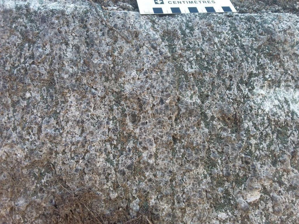
The Lac-Saint-Jean Anorthositic Suite (mPlsj, 1169 to 1135 Ma, Higgins and van Breemen, 1996; Papapavlou, 2020) is one of the most voluminous anorthositic suites in the Grenville Province, if not in the world. It covers ~30% of the area of sheet 32H01 and continues eastwards (sheets 22D and 22E). It hosts several Fe-Ti-P-V oxide mineralizations. In the mapped area, it consists of the intermediate to felsic facies (Patrick Ouest Charnockite) and the mafic and ultramafic facies. The Patrick Ouest Charnockite (mPick1, 1143 ±2 Ma, van Breemen, 2009; 1169 ±19 Ma, Papapavlou, 2020) is composed of charnockite, mangerite and alkali feldspar granite. All of these rocks are coarse grained and porphyroid, contain feldspar phenocrysts and display a rapakivi texture. The mafic and ultramafic facies comprises three subunits composed of: 1) gabbronorite with or without Fe-Ti-P oxides and coronitic leuconorite (mPlsj1); 2) anorthosite, leuconorite, gabbro, norite and layers of ultramafic rock (mPlsj2); and 3) leuconorite, anorthosite and a lesser proportion of nelsonite (mPlsj3). The mPlsj2 subunit is the most abundant and includes anorthosite and leuconorite at various degrees of plagioclase recrystallization. The nelsonite of the mPlsj3 subunit appears as lenses and locally contains large apatite crystals (e.g. the Lac Perron mineralized zone).
In addition to the Lac-Saint-Jean Anorthositic Suite, three other suites present in the south of the study area have already been mapped by Moukhsil and El Bourki (2020 and 2021). They are: 1) the Sainte-Hedwidge Intrusive Suite (mPshe1 and mPshe2, 1017.6 ±36 Ma, Papapavlou, 2019) composed of quartz syenite, porphyroid mangerite, alkali feldspar granite, gabbronorite, quartz monzodiorite, jotunite, quartz monzonite, syenogranite, and enclaves of paragneiss and granitic gneiss; 2) the highly magnetic Vertu Plutonic Suite (mPvet1 and mPvet2) consisting of hypersthene syenite, quartz syenite, alkali feldspar granite and mangerite; and 3) the Jean-Marie Intrusive Suite (mPijm) which contains charnockite, alkali feldspar granite, syenogranite, hypersthene syenite, and gabbronorite rich in enclaves of paragneiss and granitic gneiss.
The Coin Batholith (mPbcn) is a small intrusion first mapped in the NNE corner of sheet 32H02 by Moukhsil and El Bourki (2021). This batholith continues eastward (sheet 32H01) and consists of syenogranite, alkali feldspar granite, quartz monzonite containing or not hypersthene (mangerite), and a minor proportion of quartz monzodiorite. It contains enclaves of paragneiss and granitic gneiss.
New intrusions in the mapped area are: the Long and Écluse batholiths, the Tommy Intrusive Suite and the Rivière Noire Intrusion.
The Long Batholith (mPlon) is very voluminous and polyphase. It consists of alkali feldspar granite, mangerite, quartz syenite, hypersthene syenite and gabbronorite. It also contains small proportions of syenogranite, quartz monzodiorite and granodiorite. It is bounded to the north by a major fault that follows the shape of its contact with the host rocks. This fault likely played a role in its emplacement.
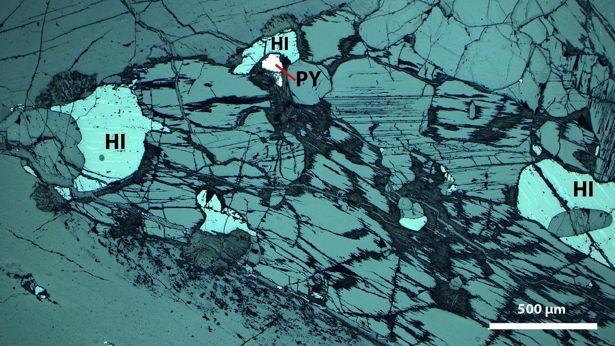
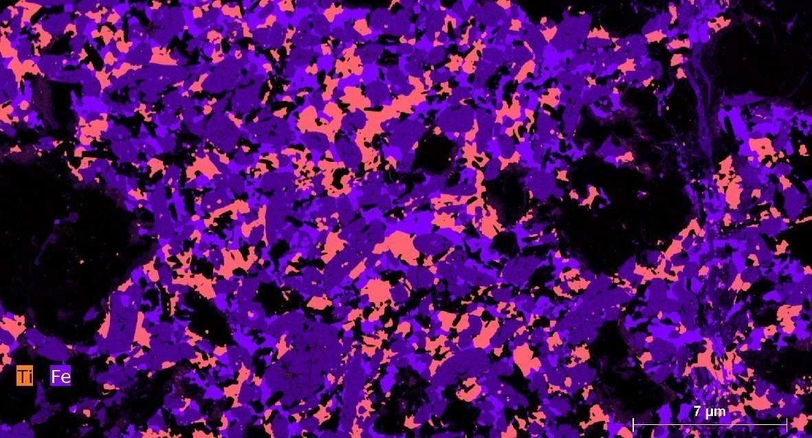
The Écluse Batholith (mPecl) consists of two subunits injected into the surrounding rocks, such as the Lac-Saint-Jean Anorthositic Suite and the Grondin Plutonic Suite. The mPecl1 subunit consists of alkali feldspar granite, quartz syenite, alkali feldspar syenite, gabbronorite and leuconorite. The mPecl2 subunit consists mainly of gabbronorite containing Fe-Ti ± P oxides (magnetite, apatite, ilmenite) and pyroxenite containing sulphides (pyrite, chalcopyrite and pyrrhotite).
The Tommy Intrusive Suite (mPtmm), which is magnetic in nature, is subdivided into two distinct polyphase intrusions containing three informal units. The first, mPtmm1, consists mostly of gabbronorite, alkali feldspar granite, syenogranite, and some outcrops of leuconorite and mangerite. The syenogranite is cut by a carbonatite dyke, whose composition is associated with a fine-grained ultramafic rock rich in specular hematite. The second unit, mPtmm2, represents ~2% of the intrusion and appears as a lens of quartz monzodiorite and monzodiorite. The third unit, mPtmm3, is composed of mangerite, hypersthene syenite, quartz monzodiorite, alkali feldspar granite, and lesser proportions of gabbronorite and leuconorite enclaves.
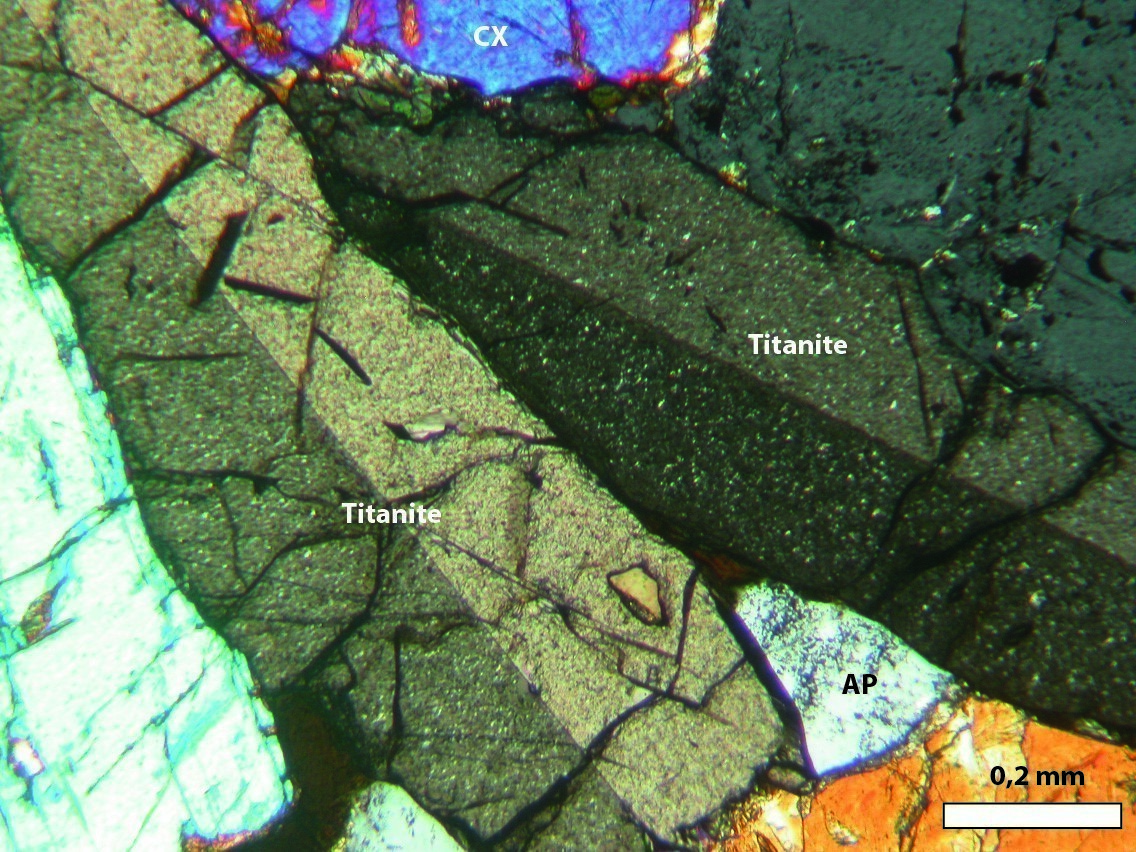
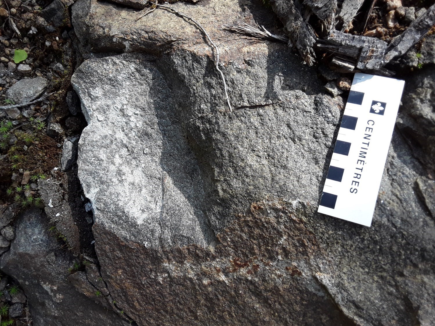
 The Rivière Noire Intrusion (mPirn) is elliptical and covers an area of ~15 km². It cuts the Lac-Saint-Jean Anorthositic Suite. The rock is a clinopyroxenite containing apatite, titanite, and traces of K-feldspar. It is injected by veins, veinlets and dykes of syenite, alkali feldspar syenite and quartz syenite. It has potential for rare earth elements and phosphorus. The clinopyroxenite appears recrystallized, while the associated syenite appears foliated and deformed. There is some evidence of syenitic and ultramafic magmas mixing locally in the intrusion.
Neoproterozoic Intrusion
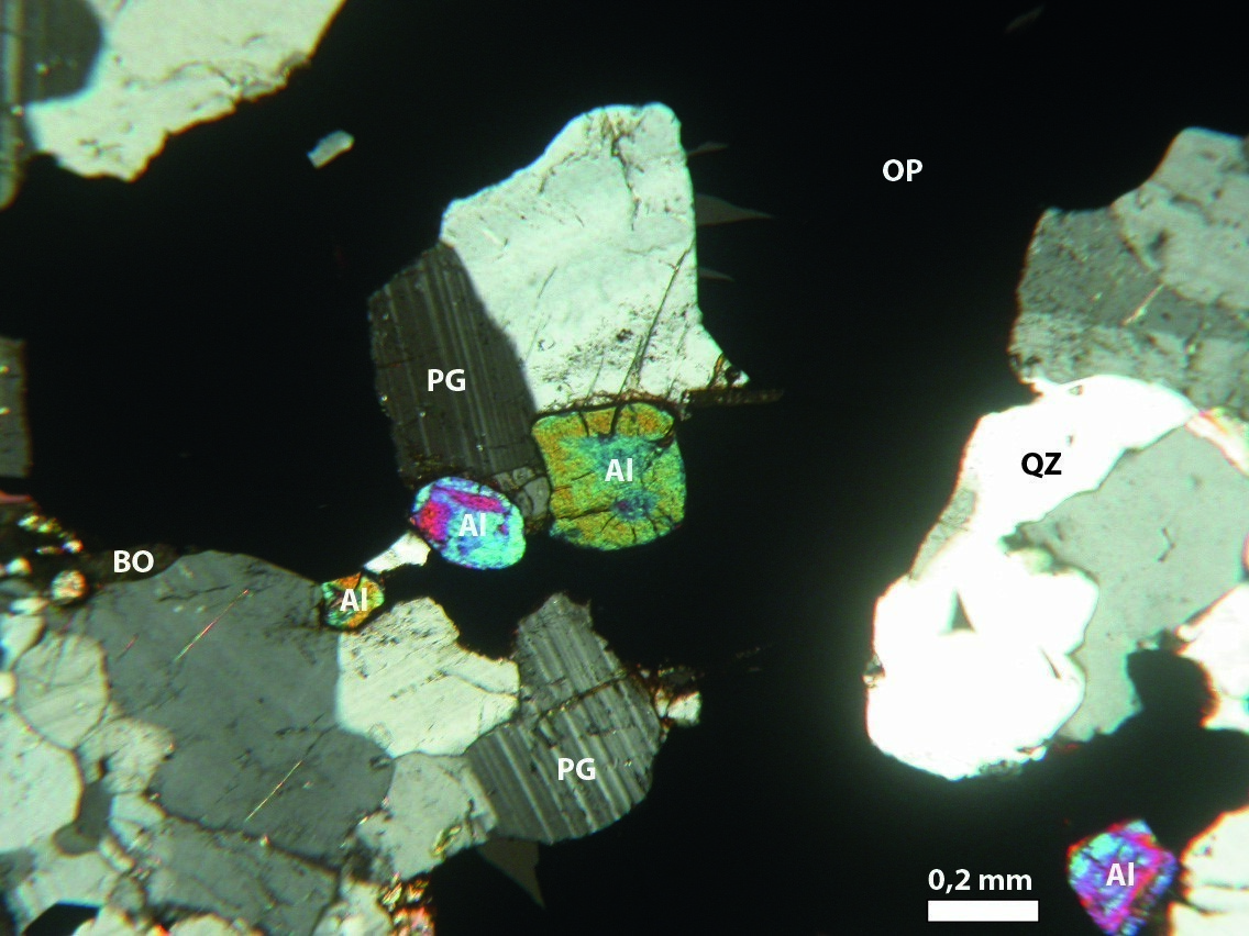
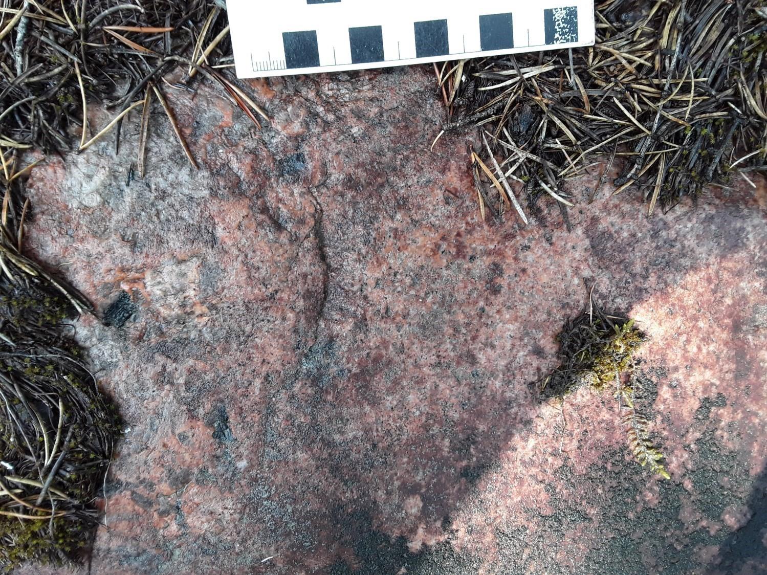
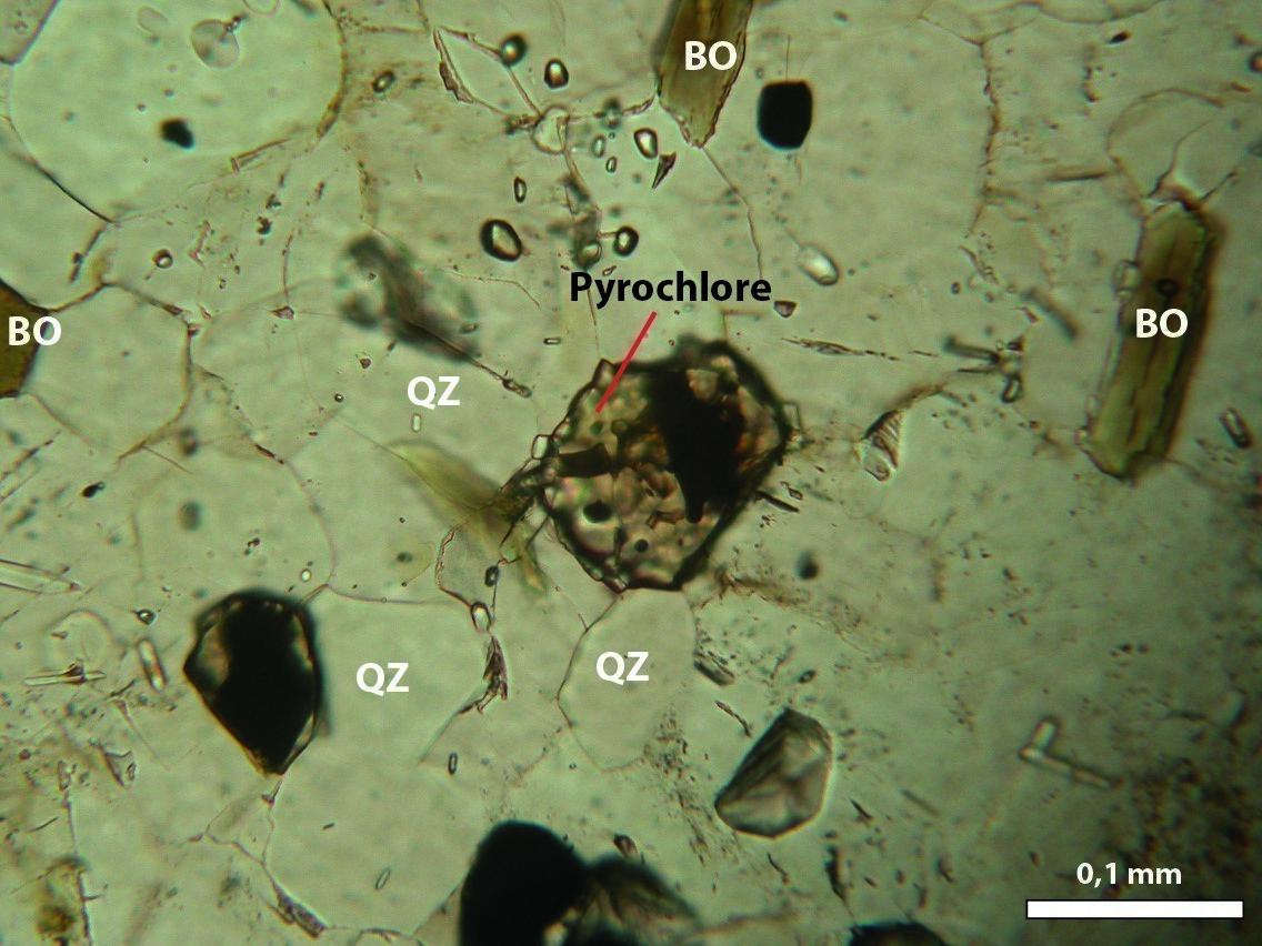
 The Crevier Alkaline Intrusion (nPiac, 957.5 ±2.9 Ma, Groulier et al., 2014, 2020) represents one of the last magmatic events in the mapped area. It has been known since the 1980s (Bergeron, 1980) for its Nb-Ta potential and it is host to several mineralized zones in these substances (e.g. Crevier mineralized zone). The edge phase (nPiac1a) is comprised of quartz syenite and coarse-grained, porphyroid syenite locally containing nepheline. This surrounds a coarse-grained syenitic and nephelinic phase (nPiac1b). The second subunit (nPiac2) contains a package of syenite and banded feldspathoidal syenite. These rocks are locally associated with carbonatite and are cut by pegmatitic swarms of syenitic dykes containing pyrochlore and megacrysts of nepheline and albite. The third subunit (nPiac3), composed of alkali feldspar syenite, was not observed during the mapping work and has been compiled from previous work (Bergeron, 1980).
 The dyke swarms of the nPiac2 unit are syenitic in composition. The rock is pegmatitic and contains megacrysts of albite and nepheline exhibiting a comb-tooth texture. The swarms are mainly located in the centre of the intrusion and are oriented parallel to each other with a mean direction of 320° and a subvertical dip to the north. The dykes locally contain veins of sodalite and phlogopite carbonatite.
Lithogeochemistry
The lithogeochemistry of units in the Dolbeau-Blondelas area is presented separately in tabular form.
Structural Geology
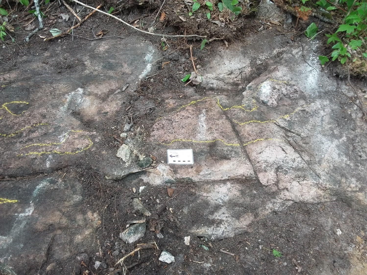
The Mesoproterozoic rocks in the region, mainly rocks from the Barrois Complex (mPboi), are generally deformed and folded. These rocks appear in the form of lenses and rafts transposed within the other plutonic rocks in the region. The folds are isoclinal with axial planes lying subparallel to the planar fabrics of the plutonic rocks. It should be noted that the primary structures of these rocks were transposed during an initial D1 deformation phase and were obliterated during the Grenvillian Orogeny (D2) and postorogenic deformation events. The result of these events is a NNE-SSW and NNW-SSE oriented structural pattern. The rocks in the region are cut by several faults and shear zones that accommodate the final emplacement of the intrusions.
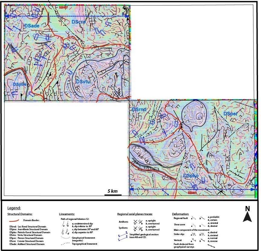
Based on the attitude of lineaments interpreted from aeromagnetic maps and the distribution of planar (D2/G2) and linear structures measured in the rocks, the Dolbeau-Blondelas area (sheets 32H01 and 32H07) has been subdivided into seven structural domains. There are three new structural domains, namely Crevier (DScre), Lac Perron (DSper) and Adélard (DSade), in addition to the four domains already defined in the Normandin (Moukhsil and El Bourki, 2020) and Girardville (Moukhsil and El Bourki, 2021) areas, which are the Lac Rond (DSrnd), Patrick Ouest (DSpko), Jean-Marie (DSjme) and Vertu (DSvtu) structural domains. The boundaries between these domains generally correspond to a change in the orientation of the main planar fabric (Sn) combined with the orientation of the regional axial planes.
The Crevier Structural Domain (DScre) occupies the NE part of the mapped area (sheet 32H07). It is mainly characterized by the emplacement of the Crevier Alkaline Intrusion and Grondin Plutonic Suite.
In stereographic projection, the poles of foliation planes (planar fabric) are distributed in the NE, NW and SW quadrants (with a high concentration in the NW quadrant), resulting in a main NE-SW orientation and a moderate eastward dip. Mineral lineations borne by planar structures are mostly concentrated in the SE quadrant with a medium lineation and have a dip component. This domain is also characterized by NNW-SSE to NNE-SSW trending faults (reverse and undetermined movement) that essentially cut the units of the Grondin Plutonic Suite.
The Lac Perron Structural Domain (DSper) occupies the NE part of the mapped area (sheet 32H01) and is dominated by the Lac-Saint-Jean Anorthositic Suite. It shows a NNE-SSW oriented mean planar fabric generally characterized by tectonometamorphic mineral foliation, magmatic foliation or mylonitic banding. In stereographic projection, the poles of this fabric's planes are concentrated essentially in two opposite locations along the E-W axis of the equatorial plane. This could be explained by a style of deformation in domes and basins with mean dips sometimes to the west, sometimes to the east. Lineations borne by these planar structures generally have an oblique component. In stereographic projection, they are mainly distributed in the SE and SW quadrants. In this domain, there are two families of faults (normal and undetermined movement) with a mean NNE-SSW and NNW-SSE direction, that cut the units of the Lac-Saint-Jean Anorthositic Suite.
The Adélard Structural Domain (DSade) occupies the NW part of the mapped area (sheet 32H07). It mainly consists of the planar fabric from units in the Festins (mPfes), Adélard (mPade) and Vertu (mPvet2) plutonic suites. These units have a mean planar fabric oriented NE-SW, generally characterized by a secondary mineral foliation (tectonometamorphic), mylonitic foliation or banding, and a gneissosity with a moderate SE dip. In stereographic projection, the poles of the planes from this foliation largely occupy the NW quadrant. The lineations borne by these planar structures are arranged in an elongated garland around the mean plane of the planar fabric, with a small concentration in the SE quadrant of the grid. They generally have an oblique component. Several faults (reverse and undetermined movement) and shear zones (dextral and undetermined movement) cut the formations of the Festins (mPfes) and Adélard (mPade) plutonic suites.
The Vertu (DSvtu) and Jean-Marie (DSjme) structural domains were defined by Moukhsil and El Bourki (2021) in the Girardville area. Their continuity to the north occupies respectively the SE and SW parts of the Dolbeau-Blondelas area (sheet 32H07). In general, the D2 planar fabric has a mean N-S (DSvtu) to NNE-SSW (DSjme) orientation.
The Lac Rond Structural Domain (DSrnd), defined in the Normandin (Moukhsil and El Bourki, 2020) and Girardville (Moukhsil and El Bourki, 2021) areas, occupies the NW and SW corners of sheet 32H01. It exhibits a fairly homogeneous planar fabric with a mean N-S orientation and a moderate eastward dip.
The Patrick Ouest Structural Domain (DSpko) has been defined in the eastern and NE parts of the Normandin area (Moukhsil and El Bourki, 2020) and continues northward into the Dolbeau-Blondelas area (sheet 32H01). The structural grain in this area trends NNE-SSW and the mean dip is oriented ESE. It is essentially represented by a tectonometamorphic mineral foliation of the D2 deformation. Mineral lineations borne by these planar fabrics generally have an oblique component and an eastward plunge.
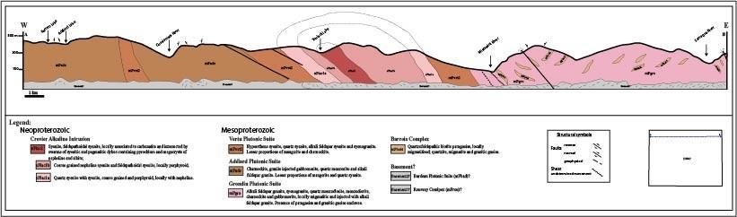
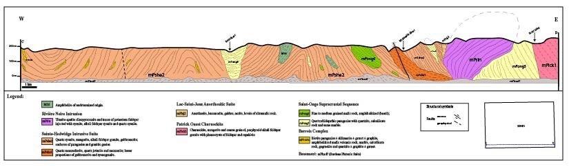
To illustrate the relationships between the various lithostratigraphic units in the Dolbeau-Blondelas area, two simplified structural sections, one labelled AB in the Crevier Alkaline Intrusion sector (sheet 32H07), and the other labelled CD in the Rivière Noire Intrusion sector (sheet 32H01), were produced with an E-W orientation.
Metamorphism
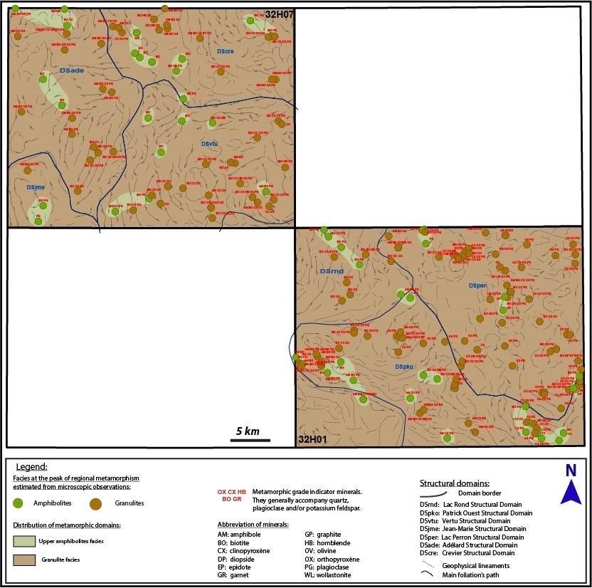
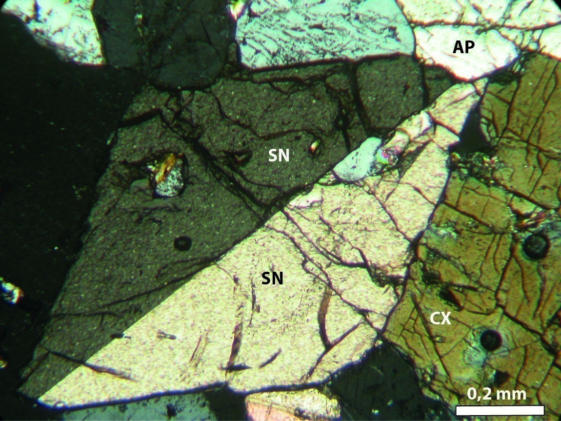
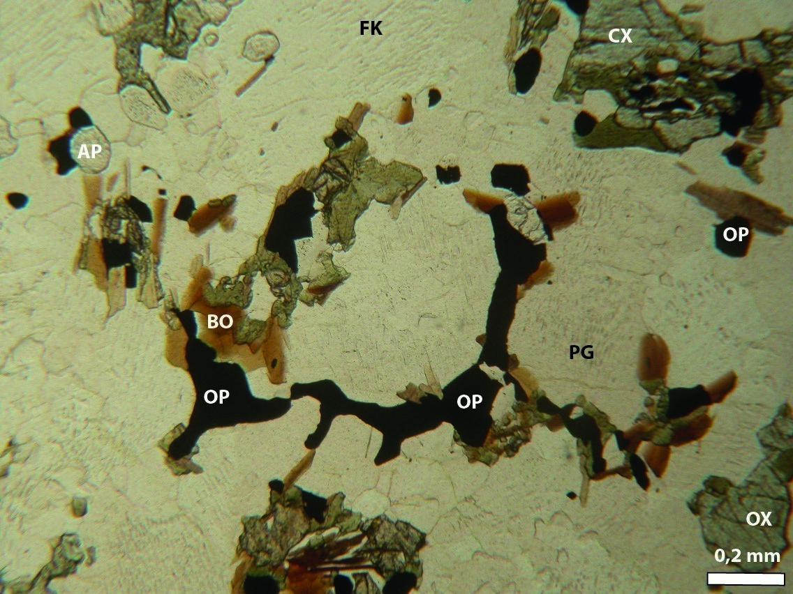
Mineralogical and structural analysis at a macroscopic and microscopic scale (216 covered and polished thin sections of samples representative of Mesoproterozoic and Neoproterozoic units) indicate that the rocks in the Dolbeau-Blondelas area (sheets 32H01 and 32H07) show substantial evidencefor amphibolite and granulite facies prograde metamorphism (simplified metamorphic map).
The rocks mapped underwent regional metamorphism, but rocks in the Saint-Onge Supracrustal Sequence (mPong1) were also affected by contact metamorphism. Evidence of regional metamorphism is found in the main unit of the Barrois Complex (mPboi4), where the rocks are generally migmatitic and have undergone partial melting. The unit contains leucosomes of granitic composition (15-20% of the rock) consistent with the planar fabric. The local presence of orthopyroxene uralitized to hornblende in the leucosome also suggests the transition from high-temperature prograde metamorphism (granulite facies) to retrograde metamorphism (amphibolite facies) in this unit. The Saint-Onge Supracrustal Sequence (mPong) contains a biotite-sillimanite-garnet ± graphite paragneiss in a granoblastic quartzofeldspathic matrix, indicating that these rocks are metamorphosed to the granulite facies. Unit mPong1, which contains wollastonite marble and calc-silicate rocks, is interpreted as a wollastonite skarn (Hébert et al., 2009). This is evidence of the contact metamorphism undergone by this subunit following the emplacement of the Lac-Saint-Jean Anorthositic Suite between 1069 Ma and 1035 Ma (Higgins et al., 2002). A metamorphic age of 1163 ±18 Ma has been estimated for this skarn (Ider, 1997; Higgins et al., 2002).
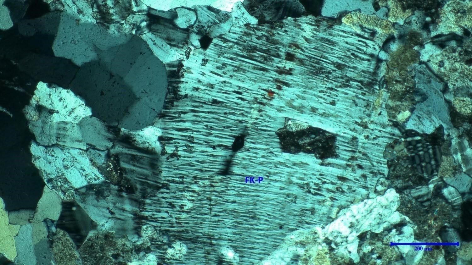
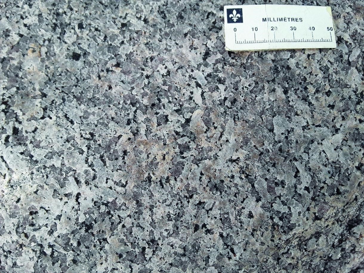
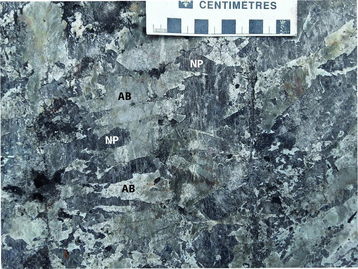
 Most felsic and intermediate plutonic rocks in the region contain orthopyroxene, clinopyroxene, perthitic feldspar and red-brown biotite (under the microscope). These observations indicate that the rocks were emplaced at a high-grade facies. Mafic and ultramafic rocks in the area contain an assemblage of plagioclase-clinopyroxene-orthopyroxene-hornblende ± garnet. This paragenesis, locally visible in the form of crowns, indicates that these rocks are metamorphosed to the granulite facies.
Economic Geology
The Dolbeau-Blondelas area contains several mineralized zones and prospective zones for four types of mineralization:
- Rare earth element and phosphorus mineralization associated with ultramafic and syenitic rocks;
- Rare earth element mineralization ± Th ± Nb ± Ta associated with granitic pegmatite dykes, syenitic intrusive rocks, alkali feldspar granite, and carbonatites;
- Magmatic Fe-Ti (± P ± V) mineralization associated with mafic to ultramafic intrusive rocks;
- Magmatic Cu-Ni mineralization in mafic and ultramafic intrusive rocks.
The table below shows the analytical results for known mineralized zones in the area, including eight new zones discovered during our work and fifteen known mineralized zones.
| Name | Contents | Comments |
|---|---|---|
| Mineralization Associated With Granitic Pegmatites | ||
| AM86 | 7214.15 ppm REE (G) | |
| Blondelas | 902 ppm Th (G) | |
| Claire-ETR | 2407.35 ppm REE (G) | |
| Lac Tommy | 469 ppm Nb (G) | |
| ME-1163 | 5568 ppm REE (G) | |
| ME-1165 | 2357 ppm REE (G) | |
| Mineralization Associated With Carbonatites | ||
| Grand Lac Brochet | 2440.31 ppm REE (G) | |
| Mineralization of Undetermined Type | ||
| Aligas | 2427 ppm REE (G) | |
| Name | Contents | Comments |
|---|---|---|
| Uranium-Bearing Vein Associated With Granitoids | ||
| Lefebvre | 958 ppm U (G); 580 ppm Th (G) | |
| Mineralization Associated With Carbonatites | ||
| Crevier | In 2013, measured resources are 12.47 Mt at 0.2% Nb2O5, 0.023% Ta2O5, indicated resources are 12.9 Mt at 0.19% Nb2O5, 0.023% Ta2O5, and inferred resources are 15.42 Mt at 0.17% Nb2O5, 0.025% Ta2O5 (DV 2014-01); 5110 ppm Nb over 1.5 m (R); 1883 ppm Ta (G); 1700 ppm U (G); 11,082 ppm Zr over 1 m (D); 850 ppm Th over 0.5 m (D) | |
| Crevier SE | 1590 ppm Nb (G); 210 ppm Ta (G) | |
| Niotaz | 1890 ppm Nb (G); 508 ppm Ta (G); 545 ppm U (G) | |
| Niotaz Sud | 2050 ppm Nb (G); 469 ppm Ta (G); 5083 ppm REE (G); 9880 ppm Zr (G); 528 ppm U (G); 1465 ppm La (G); 500 ppm Th (G); 2520 ppm Ce (G) | |
| Iron and Titanium Mineralization in Mafic Intrusive Rocks | ||
| Girardville | 300,000 ppm Fe over 30 m (D); 49,600 ppm Ti over 30 m (D) | |
| Iron and Titanium Mineralization in Anorthosite | ||
| Lac Perron | 524,600 ppm Fe (G); 132,300 ppm Ti (G); 5700 ppm V (G); 93,300 ppm P (G); 20.4% TiO2 (G) | |
| Lac de l'Écluse | 150,800 ppm Ti (G) | |
| Magmatic and Hydrothermal Ni-Cu-PGE Mineralization | ||
| Samaqua | 3130 ppm Cu (G) | |
| Ni-Cu Dominant (± Co ± PGE) Magmatic Mineralization Associated With Various Mafic to Ultramafic Intrusive Rocks | ||
| Lac Yenevac | 12,000 ppm Ni over 0.3 m (D); 8670 ppm Cu over 1.1 m (D) | |
| Saint-Stanislas-Nord | 3100 ppm Ni (G); 4000 ppm Cu (G); 500 ppm Co (G) | |
| Non-Metallic Substances | ||
| Crevier | The rock contains feldspar phenocrysts (microcline and albite) and nepheline. The grain size of nepheline varies in places from a few centimetres to almost 30 cm. The proportion of nepheline in the rock is ~40% to 45%. Nepheline exhibits various colours (salmon pink, brown or black). Ferromagnesian minerals are represented exclusively by biotite. Secondary minerals include magnetite, pyrrhotite, pyrite, zircon, sodalite, cancrinite, ilmenite, carbonates and pyrochlore. The other types of dykes are composed of fine to medium grained nepheline syenite. The Crevier Complex contains mineralizations in uranium, niobium and tantalum. SOQUEM's exploration work focused on an important pegmatitic nepheline syenite dyke. This rock is mineralized in niobium and tantalum. The dyke is located in the centre of the circular mass forming the southeastern part of the complex and cuts across the various lithologies. The dyke is arranged in three echeloned lenses extending over more than 3.5 km. | |
| Lac Perron | GM 68125: The best values yielded by the selected samples are 21.37 % P2O5 (Samp. 157164), 14.56% P2O5 (157167), 9.15% P2O5 (157168), 9.48% P2O5 (157166), 8.88% P2O5 (157163). | |
| Mine Delisle | The size of a phlogopite sheet is ~10 cm by 15 cm by 1.3 cm. Following his work, Berrangé (1959) estimated that the phlogopite sheets are not of commercial size and the package is of no economic value, including the sulphides encountered. In 1943, small-scale open-pit mining was carried out. The dimensions of the dyke are not available. | |
| Quebec Silica (Lac Noir) | 92%, 12%, 99%, 16% and 99.16% SiO2 (analysis of 3 selected samples of quartz, GM 07493 and GM 09209). The extent of the deposit's depth remains poorly understood (GM 66298). The best chemical analysis data obtained in 2014 indicate: # Samp. SiO2 Al2O3 Fe2O3 CaO MgO Na2O K2O Cr2O3 J 762752 98.21 0.08 < 0.01 0.03 0.11 0.01 < 0.01 < 0.01 J 762753 99.65 0.1 < 0.01 0.02 0.1 < 0.01 < 0.01 < 0.01 J762755 98.31 0.29 0.06 0.15 0.23 < 0.01 0.14 0.01 J762756 99.21 0.16 0.01 0.08 0.15 < 0.01 0.01 0.01 | |
(D): Diamond drilling; (G): Selected sample; (R): Channel - Chip Sample
The table of lithogeochemical analyses of metals of economic interest provides the location, description and analytical results for 70 selected samples in order to assess the economic potential of the area.
Known Mineralization in the Study Area
The area mapped is host to several known mineralizations. The table above includes hyperlinks to the descriptive sheets of mineralized zones.
Unknown Mineralizations Discovered During Present Work
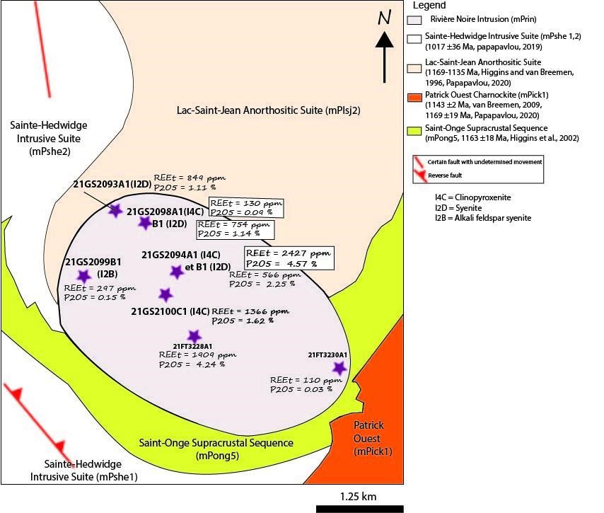
New Prospective Zone and New Rare Earth Element and Phosphorus Mineralized Zone Associated with the Rivière Noire Intrusion
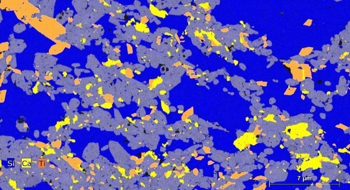
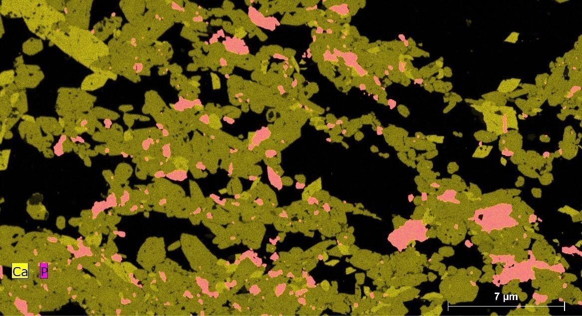 This sector comprises a new mineralized zone (Aligas) and a new prospective zone (Rivière Noire) for rare earth elements (REE) and phosphorus associated with an intrusion of heterogranular ultramafic rock (clinopyroxenite). The latter is injected with dykes, veins and veinlets of intermediate composition (syenite and alkali feldspar syenite). The clinopyroxenite contains clinopyroxene, titanite, monazite, apatite, and traces of olivine and K-feldspar (xenocrysts). This intrusion is associated with a geophysical anomaly. It is irregularly lenticular and measures ~5 km long by 3 km wide along a NW-SE axis. Analysis of several selected samples yielded contents of up to 2427 ppm REE and 4.57% P2O5 (21-GS-2094-A1).
New Prospective Zones in Fe-Ti ± P ± V Associated with Mafic and Ultramafic Intrusive Rocks
Several mafic and ultramafic intrusions favourable to the prospecting of Fe-Ti ± P ± V oxide mineralized zones have been identified in the mapped area. They are the prospective zones of Murky and Sasseville (sheet 32H01), as well as Basile and Milakutu (sheet 32H07).
 The Murky prospective zone consists of a coarse- to medium-grained gabbronorite from the Écluse Batholith (mPecl2). The rock contains apatite, hemo-ilmenite and magnetite associated with ~1% to 2% of millimetre-sized grains of disseminated sulphides (pyrite and pyrrhotite). Locally, the gabbronorite is associated with a rusty pyroxenite containing iron oxides. Analysis of three selected samples yielded 4.49% P2O5 and 16.9% Fe (21-ME-1015-A1), 3.37% P2O5 and 9.74% Fe (21-ME-1015-B1), and 4.08% P2O5 and 13.4% Fe (21-ME-1017-A1).
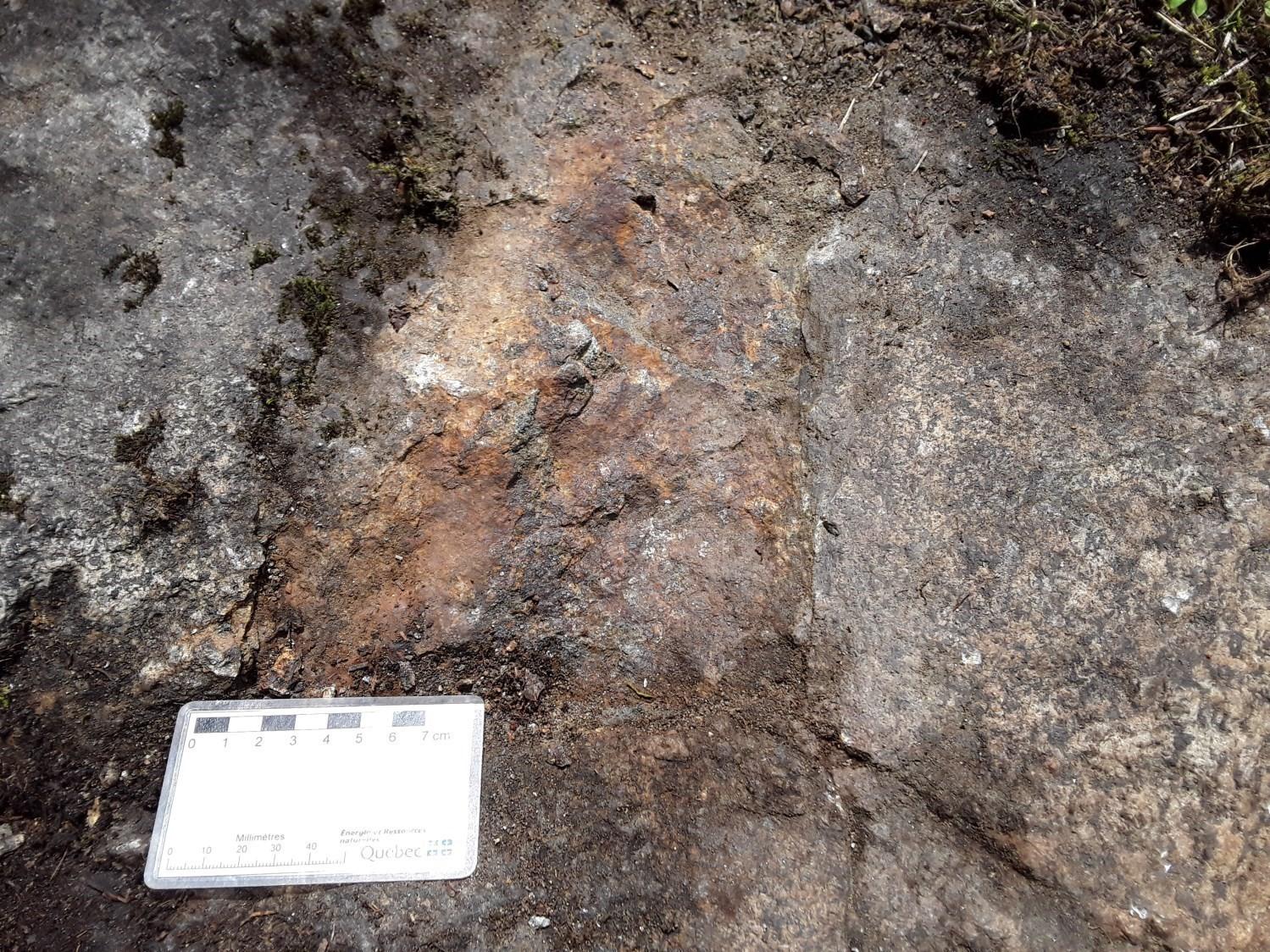
 The Sasseville prospective zone consists of a leuconorite characterized by the presence of rusty clusters of ultramafic rock containing >90% magnetite, hemo-ilmenite and apatite. These fine- to medium-grained clusters are 10 cm to 50 cm in diameter. A selected sample (21-AM-60-B1) yielded 31.7% Fe, 6.77% TiO2, 2.51% P2O5, 271 ppm Zn, 21 ppm Nb and 138 ppm Co.
 The Basile prospective zone is located in the SE portion of sheet 32H07, ~2 km north of Lake Basile. It consists of a gabbronorite (outcrop 21-FT-3034) containing 20 cm large rusty clusters rich in disseminated sulphides (1-2% pyrite, chalcopyrite and pyrrhotite) and a jotunite (21-FT-3031-A1) containing magnetite, pyroxene and biotite. Analysis of two selected samples yielded contents of 15.6% Fe, 4.47% TiO2, 264 ppm Zn and 127 ppm Cu (21-FT-3034-B1), and 11.6% Fe, 2.06% TiO2 and 163 ppm Zn (21-FT-3031-A1).
The Milakutu prospective zone is located ~1.1 km north of Lake Milakutu and 1 km west of Lake Lucien. The rock is a coarse-grained gabbronorite containing orthopyroxene, clinopyroxene, amphibole, biotite, magnetite and apatite. It is rusty and displays a coronitic structure. Analysis of a selected sample (21-FS-4001-A1) yielded 14.2% Fe, 1.36% P2O5, 3.48% TiO2, 310 ppm Cu, 167 ppm Zn and 35.5 ppm Nb.
New Mineralized Zones and Prospective Zones for Rare Earth Elements ± Th ± Nb ± Ta Associated With Granitic Pegmatite Dykes, Syenitic Intrusive Rocks, Alkali Feldspar Granite and Carbonatite Dykes
Several new mineralized zones and prospective zones for REE ± Th ± Nb ± Ta were defined in the study area. These include:
 The Grand Lac Brochet mineralized zone which is located ~580 m north of Grand Lac Brochet and 600 m northeast of Petit Lac à Truite (western part of sheet 32H01). A fine- to medium- grained carbonatite dyke displays a massive structure. At the edge, it contains clusters of apatite and is cut by several millimetric veinlets of dark filling minerals (arfvedsonite? or iron oxides?). The dyke is oriented 355°/66° and is 10 cm to 50 cm thick. It cuts a fine- to medium- grained syenogranite with a mylonitic structure. It is mainly composed of calcite, biotite and apatite. The dyke is associated with an iron formation-type rock containing specular hematite and millimetric cherty layers. Sample 21-FS-4082-D1 returned contents of 2440.31 ppm REE and 6.52% P2O5.
 The Claire-ETR mineralized zone, located ~2 km NNE of lakes Claire and Lucien (western part of sheet 32H07), corresponds to a weakly deformed pegmatite dyke with a granitic composition oriented 230°/75°. It is 30 cm to 40 cm thick and cuts a granite composed of gabbronorite boudins and centimetric pegmatite injections. The rare earth elements mineralization is associated with allanite. Sample 21-GS-2053-D1 returned contents of 2407.35 ppm REE (including 1500 ppm Ce, 625 ppm La, 417 ppm Nd and 127 ppm Pr) and 26 ppm Pb. Approximately 500 m south of the latter, another selected sample (21-FS-4116-B1) returned a content of 937 ppm REE (total).
The Lac Tommy mineralized zone is located ~1.7 km west of Lake Tommy and 1.95 km north of Lake Loup-Cervier (western part of sheet 32H01). The pegmatite dyke is 50 cm to 1 m thick and is oriented 240°/43°. It cuts a coarse-grained foliated hypersthene monzodiorite (jutonite) containing sulphides (pyrite) and apatite. The dyke is composed mostly of K-feldspar, magnetite, quartz, biotite and possibly pyrochlore. Analysis of selected sample 21-FS-4033-B1 revealed contents of 469 ppm Nb, 12 ppm Ta, 308 ppm Y, 50 ppm Pb and 666.67 ppm REE.
 The outcrop (21-AM-86), locating the AM86 mineralized zone, is found ~2.15 km south of Lake Kamishakamatsh (central part of sheet 32H07). It consists of a pegmatite dyke oriented 225°/45° and 15 cm to 20 cm thick. It cuts a granitic gneiss displaying a granoblastic and porphyroclastic texture. The rock is composed mostly of K-feldspar, plagioclase, quartz, allanite and biotite. Analysis of a selected sample (21-AM-86-B1) returned contents of 7214.85 ppm REE (including 3600 ppm Ce, 1870 ppm La, 1140 ppm Nd and 368 ppm Pr), 242 ppm Th and 32 ppm Pb.
 The Agapes prospective zone contains a Nb-Zn ± Ta mineralization associated with intermediate intrusive rocks (jotunite, quartz monzodiorite, syenite and mangerite). It is located ~2.5 km NW of Lake Agapes (sheet 32H07). Analysis of selected samples returned contents of 28.1 ppm Nb and 152 ppm Zn (21-FS-4008-A2), 35.9 ppm Nb (21-FS-4006-A1), 41.2 ppm Nb (21-FS-4006-B1), 90.6 ppm Nb and 6.38 ppm Ta (21-FT-3046-C1).
New Prospective Zone for Magmatic Cu-Ni Mineralization in Mafic and Ultramafic Intrusive Rocks
 The Yanevac prospective zone consists of a rusty, strongly altered, coarse- to medium-grained ultramafic rock (olivine pyroxenite). It contains millimetre-sized grains of disseminated sulphides (2-4%, pyrite, pyrrhotite and chalcopyrite) and graphite. There are a few centimetric grains of pyrite in places. The mineralized zone is 1 m thick and oriented 35°/75° within a porphyroclastic garnet anorthosite. Two selected samples returned the following contents: 298 ppm Zn, 211 ppm Cu, 28.10% Fe, 570 ppm V, 54.4 ppm Sc and 127 ppm Co (21-FT-3043-B1), as well as 286 ppm Zn, 241 ppm Cu, 156 ppm Ni, 48 ppm Mo, 52.4 ppm Sc, 27.2% Fe and 162 ppm Co (21-FT-3043-B2).
The 1:50,000 scale mapping of the Dolbeau-Blondelas area has improved geological knowledge in terms of stratigraphic, structural and metallogenic descriptions. It has led to the discovery of new intrusions, faults, prospective zones and promising mineralized zones. One of these discoveries is the Rivière Noire Intrusion (ultramafic, alkaline, containing titanite and apatite) and its mineralization in rare earth elements and phosphorus. However, a number of issues remain to be studied, such as: estimating the age of this intrusion, identifying the rare earth element-bearing minerals, defining the type of mineralization (skarn?, metasomatic?, etc.), comparing this intrusion, located roughly in the Waswanipi-Saguenay corridor, with other alkaline intrusions such as those of Crevier, Girardville and Saint-Honoré, and finally looking for other similar intrusions in sheets further north (e.g. sheets 32H08 and 22E05).
Pending the results of the ongoing dating analysis and the subsequent completion of a thematic study in collaboration with academics, these issues can be resolved.
| Authors | Abdelali Moukhsil, P.Geo., Ph.D., abdelali.moukhsil@mern.gouv.qc.ca Mhamed El Bourki, GIT, M.Sc., mhamed.elbourki@mern.gouv.qc.ca |
| Geochemistry | Fabien Solgadi, P.Geo., Ph.D. |
| Geophysics | Rachid Intissar, P.Geo., M.Sc. |
| Potential assessment | Virginie Daubois, P.Geo., M.Sc. |
| Logistics | Marie-Dussault, coordinator |
| Geomatics | Sylvie Tétreault Kathleen O’Brien |
| Template and content compliance | François Leclerc, P.Geo., Ph.D. |
| Coaching/mentoring and critical review | Fabien Solgadi, P.Geo., Ph.D. |
| Organization | General Direction of Géologie Québec, Ministère de l’Énergie et des Ressources naturelles, Government of Québec |
Acknowledgements:
This Geological Bulletin was made possible through the cooperation of many people who actively took part in the various stages of the project. We would like to thank geologists Fabien Solgadi and Francis Talla Takam, geological engineer Gaëlle St-Louis, and students Zacharie Dagenais, Samuel Savard, Yasmine Souilah and Alexis Primeau-Ouellet. The geological exchanges and discussions with Dr. Louise Corriveau were very beneficial.
References
Publications of the Gouvernment of Québec
BERKEY, C.P., 1923. Rapport d'un levé géologique de reconaissance couvrant la région Saguenay–Lac-Saint-Jean, Assessment work submitted to the Governement of Québec; GM 18667, 56 pages, 6 plans
EL AMRANI, M., 2020. Évaluation du potentiel minéral à partir d'un levé géologique du Quaternaire dans la partie SE de la rivière Mistassini (SNRC 32H01, 32H02, 32H07 et 32H08). MERN; ET 2020-02, 14 pages.
EL AMRANI, M., FOURNIER, N., 2020. Analyse des minéraux indicateurs des sédiments glaciaires et fluvioglaciaires de la partie SE de la région de la rivière Mistassini. MERN, IOS SERVICES GÉOSCIENTIFIQUES INC; DP 2019-04, 382 pages.
GROULIER, P.A., OHNENSTETTER, D., ANDRÉ-MAYER, A.S., ZEH, A., SOLGADI, F., MOUKHSIL, A., EL BASBAS, A., 2014. Étude des minéralisations en Nb-Ta de l'Intrusion alcaline de Crevier. UMR 7359 GEORESSOURCES, AQAT - URSTM, GOETHE UNIVERSITAT, MERN; MB 2014-33, 68 pages, 11 plans.
HEBERT, C., VAN BREEMEN, O., CADIEUX, A.-M., 2009. Région du Réservoir Pipmuacan, (SNRC 22 E) : Synthèse géologique. MRNF, COMMISSION GÉOLOGIQUE DU CANADA; RG 2009-01, 59 pages, 1 plan.
INTISSAR, R., BENAHMED, S., 2015. Levé magnétique aéroporté dans le secteur ouest du Lac-St-Jean, Province de Grenville. MERN, GOLDAK AIRBORNE SURVEYS; DP 2015-06, 7 pages, 2 plans.
LANDRY, D., 1981. Campagne de sondage et de prospection, projet Crevier 10-745. SOQUEM, Assessment work submitted to the Governement of Québec; GM 37273, 335 pages, 68 plans.
LAURIN, A.F., SHARMA, K.N.M., 1975. Région des rivières Mistassini, Péribonca, Saguenay (Grenville, 1965-1967). MRN; RG 161, 103 pages, 10 plans.
MOUKHSIL, A., DAOUDENE, Y., 2019. Géologie de la région du lac des Commissaires, Province de Grenville, région du Saguenay-Lac-Saint-Jean, Québec, Canada. MERN; BG 2019-01, 1 map.
MOUKHSIL, A., EL BOURKI, M., 2020. Géologie de la région de Normandin, Province de Grenville, région du Saguenay-Lac-Saint-Jean, Québec, Canada. MERN; BG 2020-01, 2 plans.
MOUKHSIL, A., EL BOURKI, M., 2021. Géologie de la région de Girardville, Province de Grenville, région du Saguenay - Lac-Saint-Jean, Québec, Canada. MERN; BG 2021-02, 1 plan.
PAPAPAVLOU, K., 2019. U-Pb geochronology report, Grenville 2018-2019. GEOTOP, MERN; MB 2019-11, 21 pages.
PAPAPAVLOU, K., 2020. U-Pb geochronology report, Grenville 2019-2020. GEOTOP, MERN; MB 2020-09, 25 pages.
ROSS, S.H., 1950. Geological reconnaissance of an area north and east of lake St. John from Chibougamau road east to the Shipshaw watershed. MRN; DP 483, 26 pages, 2 plans.
VAN BREEMEN, O., 2009. Report on the U-Pb geochronology for the Pipmuacan Reservoir Region. GEOLOGICAL SURVEY OF CANADA; MB 2009-04, 13 pages.
Other Publications
BERGERON, A., 1980. Pétrographie et géochimie du complexe igné alcalin de Crevier et de son encaissant métasomatisé. Université du Québec à Chicoutimi; master's thesis, 129 pages. Source.
BERRANGE, J.P., 1962. The plutonic geology of part of the Grenville Province North of Lake St-John, Quebec. University of London; Ph. D. thesis.
GROULIER, P.-A., TURLIN, F., ANDRÉ-MAYER, A.-S., OHNENSTETTER, D., CRÉPON, A., BOULVAIS, P., POUJOL, M., ROLLION-BARD, C., ZEH, A., MOUKHSIL, A., SOLGADI, F., EL BASBAS, A., 2020. Silicate-Carbonate Liquid Immiscibility: Insights from the Crevier Alkaline Intrusion (Quebec). Journal of Petrology, volume 61, Issue 3, pages 1-39. doi.org/10.1093/petrology/egaa033
HIGGINS, M.D., MOHCINE, I., VAN BREEMEN, O., 2002. U-Pb ages plutonism, wollastonite formation, and deformation in the central part of the Lac-Saint-Jean anorthosite suite. Canadian Journal of Earth Sciences; volume 39, pages 1093-1105. doi.org/10.1139/e02-033
HIGGINS, M.D., VAN BREEMEN, O., 1996. Three generations of AMCG magmatism, contact metamorphism and tectonism in the Saguenay−Lac-Saint-Jean region, Grenville Province, Canada. Precambrian Research; volume 79, pages 327-346. doi.org/10.1016/0301-9268(95)00102-6
IDER, M., 1997. Géochronologie, géochimie et pétrologie des roches métamorphiques et ignées autour du gisement de wollastonite du canton de St-Onge. Université du Québec à Chicoutimi; master's thesis, 167 pages. Source
EL BOURKI, M., MOUKHSIL, A., 2022. Geology of the Dolbeau-Blondelas Area, Grenville Province, Saguenay–Lac-Saint-Jean Region, Quebec, Canada. MRNF; BG 2022-02, 1 plan.
17 février 2026