


_A")


AA")


In Essence
The summer 2019 geological survey in the Parent Lake area is the second year of a 1:50 000 scale mapping program of the Northern Domain of the Ungava Trough in the Churchill Province of Nunavik. The map covers NTS sheet 35G11, the SW quadrant of sheet 35G14 and a small part of the NW quadrant of sheet 35G06. The Northern Domain is bounded to the north by the Narsajuaq Arc and the Kovik Complex, and to the south by the Southern Domain of the Ungava Trough.
The southern part of the area consists mainly of volcano-sedimentary units and the northern part displays predominantly intermediate to mafic intrusive units.
The southern part includes, from south to north: 1) tholeiitic basalt of the Chukotat Group; 2) polymictic conglomerate and arenite of the Hubert Formation, which unconformably overlie the Chukotat Group; and 3) basaltic to dacitic volcanic rocks of the Parent Group, with at least four exhalative and sedimentary levels. Units of the Parent Group were determined from structural characteristics and geochemical signatures. The E-W oriented and kilometre-thick Qiqavik Fault cuts volcano-sedimentary units and ultramafic to felsic intrusions. This fault represents a potential site for gold mineralization associated with widespread carbonatization.
The northern part contains mainly heterogeneous and recrystallized intrusions of intermediate to mafic composition and turbiditic metasedimentary rocks. The NW area is separated by the SW-NE oriented Ammaluttuq Deformation Zone. The roof of this zone contains rocks of higher metamorphic grade, as well as amphibolite of geochemical affinity comparable to one of the Parent Group units.
Methodology
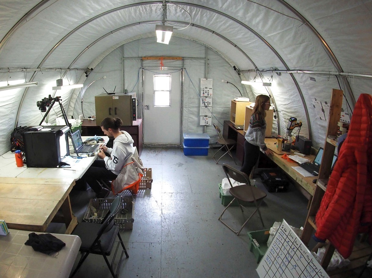
The Parent Lake area was mapped using the established methodology for surveys conducted in isolated areas without road access. The geological mapping work was carried out by a team of three geologists, three geologists in training and eight students between 11 July and 4 September 2019.
The mapping and synthesis of the Parent Lake project has produced and updated information presented in the table to the right.
| Element | Number |
|---|---|
| Described outcrop (“geofiche”) | 1094 outcrops |
| Total lithogeochemical analysis | 241 samples |
| Lithogeochemical analysis of metals of economic interest | 238 samples |
| Geochronological analysis | 11 samples |
| Covered thin section | 252 |
| Polished thin section | 6 |
| Sodium cobaltinitrite stain | 37 |
| Magnetic susceptibility measurement | 779 |
| Density measurement | 782 |
| Portable pXRF analysis | 580 |
| Sample photo | 1584 |
| Stratigraphic unit | 15 |
| Mineralization record | 12 |
Deployment of a Field Laboratory
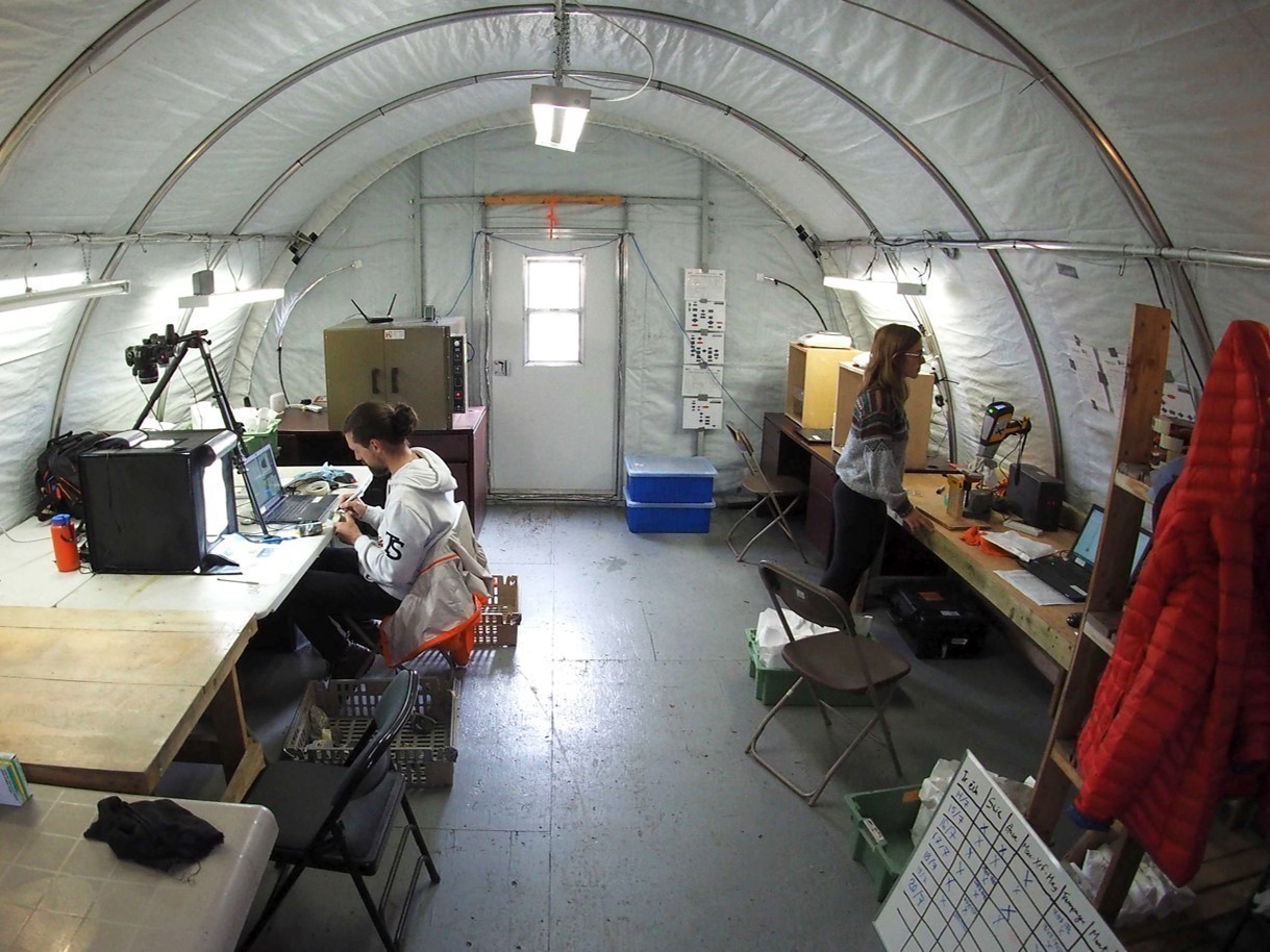
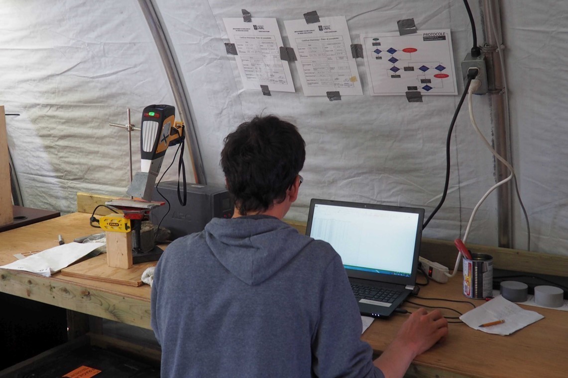
The Parent Lake area was targeted to test new data acquisition protocols and methods, as a field laboratory prototype. Measurements on rock samples were taken continuously during the geological mapping program. Measurements included density, magnetic susceptibility, systematic photography of samples as well as chemical analysis using a portable X-ray fluorescence analyzer (pXRF). Two students carried out measurements on the majority of the main lithologies observed in outcrops and on some secondary lithologies considered important, such as lithologies of volcanic origin.
Measurements of physical properties were subject to the protocols established by Christian Dupuis (Université Laval), in particular measurements of magnetic susceptibility and density (adapted to field conditions). The pXRF data were subject to an acquisition protocol and calibration implemented as part of a university project (Ross, 2019). The instrument consists of a Delta Innov-X analyzer from Olympus. The final data were corrected by correlation with lithogeochemical analyses carried out in 2018 during the calibration of the instrument. Integration of the data during mapping work allowed proposing in situ preliminary stratigraphy of the Parent Group, in addition to detecting certain cryptic alterations.
Previous Work
The table below lists the work that has been done in the study area since 1883. It also includes references cited in the report. An exhaustive list can be found in the EXAMINE documentary database.
| Author(s) | Type of Work | Contribution |
|---|---|---|
| Geological survey | Initial geological survey work in the Superior and Churchill provinces on the Hudson Bay and Hudson Strait coasts | |
| Bergeron, 1957 | Economic geology | Identifying the Ni-Cu economic potential of the Cape Smith Belt (Southern Domain) |
| Small-scale regional geological rock mapping | First systematic mapping of the Ungava Orogen, covering in particular sheet 35G | |
| 1:50 000-scale regional geological rock mapping | Geology of sheets 35G03, 35G06, 35G07, 35G10, 35G11, 35G14 and 35G15 | |
| Giovenazzo, 1985 | Economic geology | Characterizing mineralization in NTS sheets 35G06, 35G07, 35G08, 35G09, 35G10 and 35G11 |
| Mining exploration | Exploration work targeting Parent Group’s exhalative layers and shear corridors in volcanic rocks | |
| Petrological and geochemical studies | Geochemical characterization of extrusive volcanic rocks and intrusions of the Povungnituk, Chukotat, Parent groups and the Cape Smith Suite | |
| Geochronology | U-Pb dating of the Watts, Povungnituk and Parent groups and the Cape Smith Suite, and geodynamic implications | |
|
Daigneault, 1997 |
Quaternary events in Northern Nunavik |
Compilation and mapping of Quaternary formations in Northern Ungava |
| St-Onge et al.,1988 | Geochronology, geochemistry | First geodynamic model of the Ungava Orogen |
| Tectonic models | Regional geodynamic models | |
| Lithostratigraphic syntheses | Synthesis geological map and stratigraphic lexicon of the Ungava Orogen | |
| Maurice and Lamothe, 2012 | Geochemical survey of lake bottom sediments and reanalysis of old samples | Generation of regional exploration targets from anomalous geochemical contents |
| Intissar et al., 2014 | Geophysics | Airborne regional magnetic and radiometric surveys |
| Mining exploration | Discovery of gold boulders following a till survey targeting regional lake-bottom sediment anomalies, followed by several prospecting, geophysical and drilling campaigns on shear corridors in volcanic rocks of the Parent Group | |
| Allard, 2014 | Mining exploration | Discovery of gold-silver-copper-bearing quartz veins following the creation of regional lake-bottom sediment targets in the NW section of the mapped area |
| Bleeker and Kamo, 2018 | Geochronology, geochemistry | Lithostratigraphic reinterpretation of the Southern Domain |
Lithostratigraphy
The study area is located in the south of the central part of the Northern Domain, the latter being situated in the centre of the Ungava Orogen. Large thrust faults juxtapose the Northern Domain and the Narsajuaq and Kovik domains to the north, and the Cape Smith Belt (or Southern Domain) to the south. The Bergeron Fault separates the Northern and Southern domains.
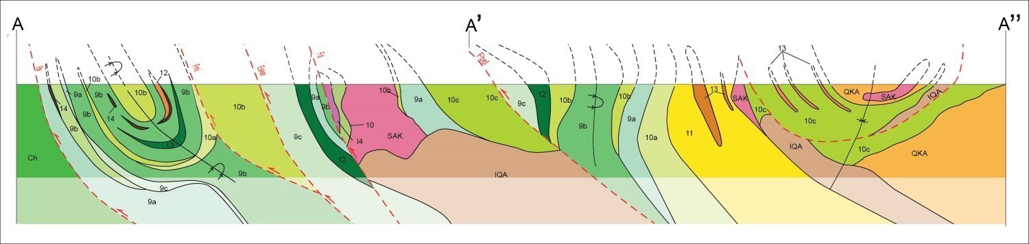
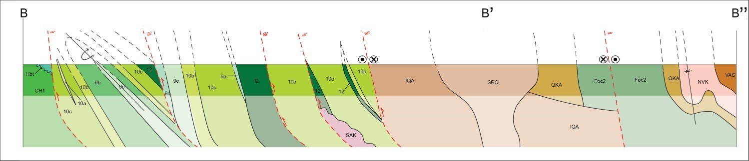
The diagrams below show the constituent units of the main tectonostratigraphic subdivisions of the area, taking into account relationships observed in the field, their geographical distribution and their relative size. The position of observation sites of reliable stratigraphic polarity is also shown.
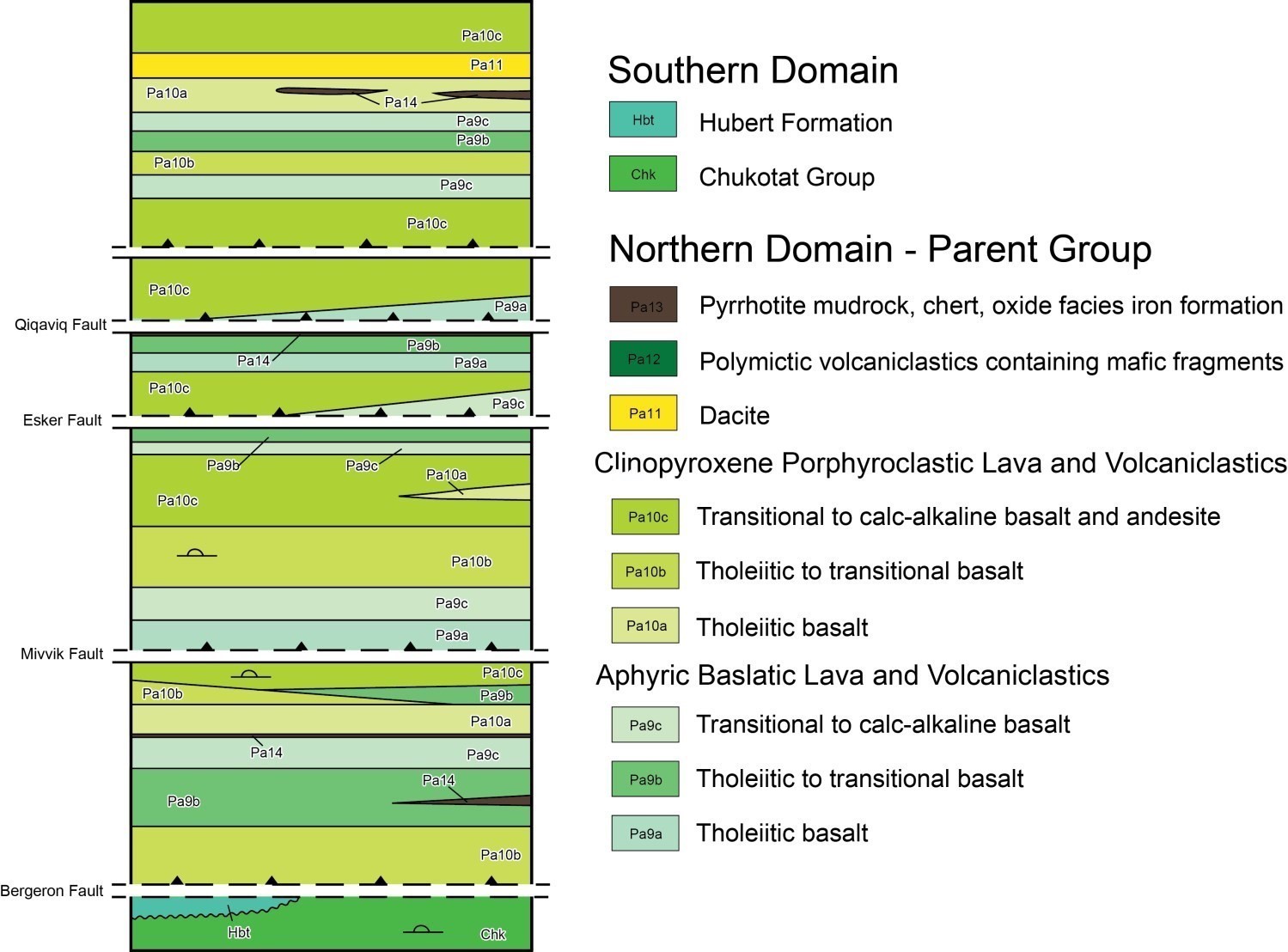
Southern Domain
In the mapped area, the Chukotat Group (Bergeron, 1959, Francis and Hynes, 1979; Roy, 1984) consists of olivine porphyritic basalt (pPch1) at the bottom, stratigraphically overlain to the north by pyroxene porphyritic basalt (pPch2). The Chukotat Group would mark the transition from a continental rift (Povungnituk Group) to an oceanic rift (Hegner and Bevier, 1991). The pillow morphology systematically indicates a normal polarity towards the north. Basalt layers, initially reported by Giovenazzo (1989), were mapped in 2019 near sedimentary rocks of the Hubert Formation. These basalts were subjected to low temperature alteration in hematite, epidote and chlorite (pPch6b). A sulphidic mudrock bed is marked by a strong magnetic signature ~4 km south of the Bergeron Fault (Giovenazzo et al., 1995).
The Lac Esker Suite (Bédard et al., 1984; Picard et al., 1995) consists of mafic to ultramafic sills, which are cogenetic with pillow volcanic rocks of the Chukotat Group, and represent their feeder pipes.
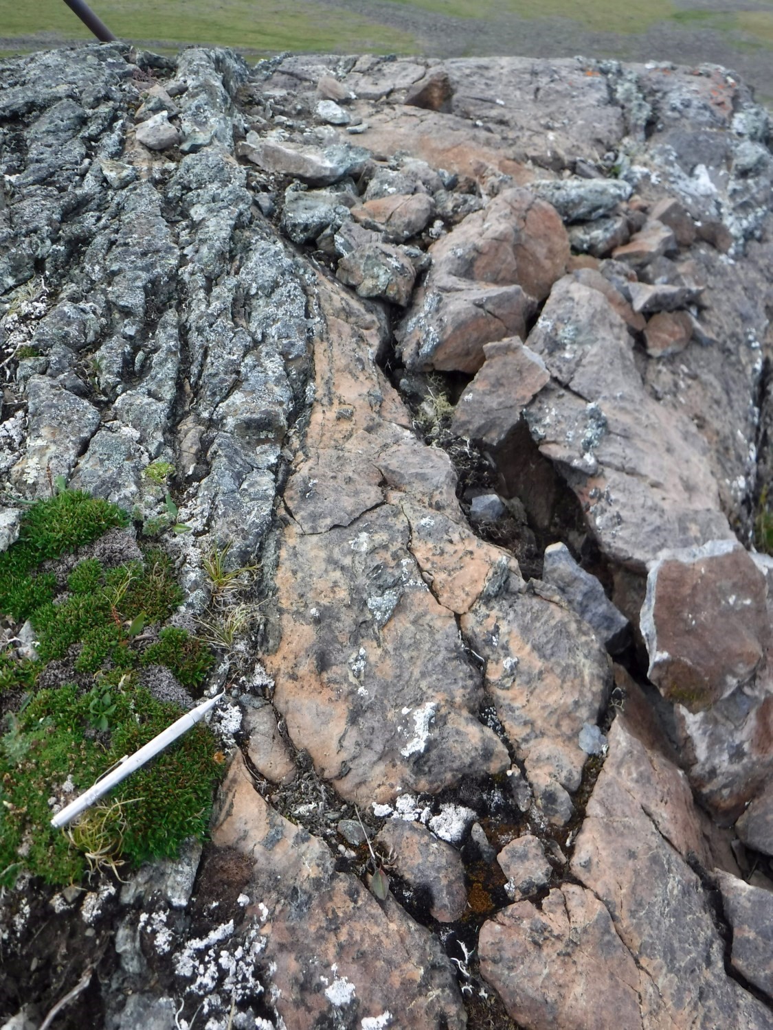
The Hubert Formation (pPhbt) is a new unit of polymictic conglomerate and red sandstone unconformably overlying (angular discordance) pyroxene basalt layers of the Chukotat Group. Sample 19-GL-2108-A was dated 1862 ±5 Ma (Davis, in preparation). It contains zircon populations dated 2000 Ma, 2100 Ma, 2300-2550 Ma and 2700-3260 Ma.
Northern Domain
Southern Part

Volcano-Sedimentary Rocks
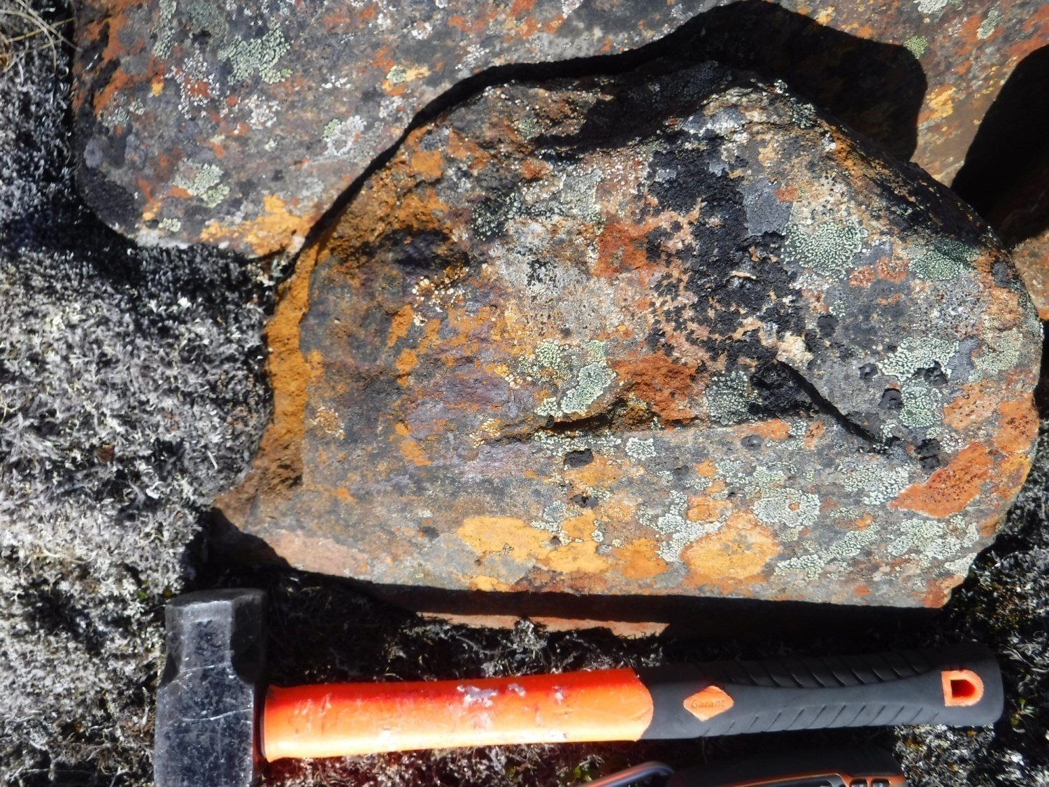
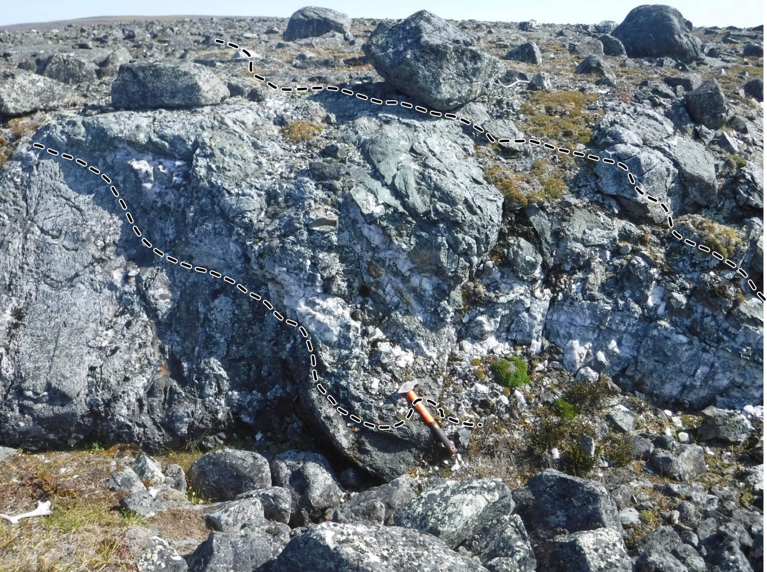
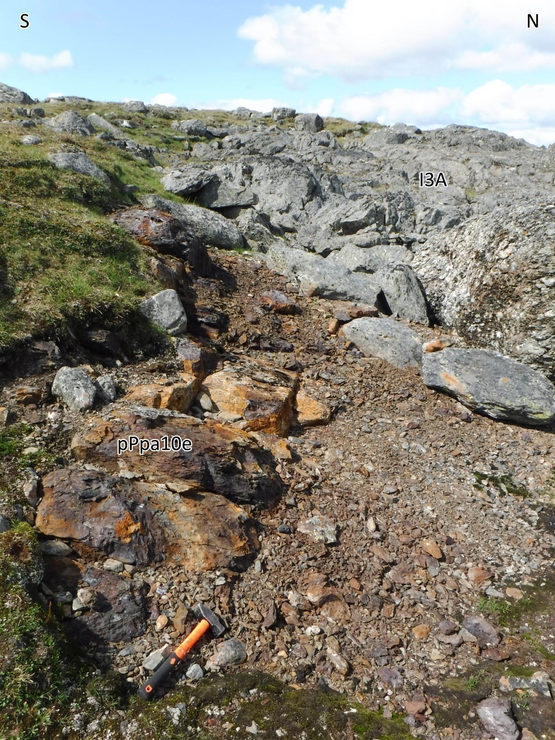
The Parent Group (Lamothe, 1994) outcrops in the southern part of the mapped area. It consists mainly of extrusive volcanic rocks and basaltic volcaniclastics, with lesser andesite and dacite layers. Basaltic lithologies are divided into six lithogeochemical groups. These divisions are based on textural characteristics (porphyritic and aphyric) and distinct geochemical signatures including magmatic affinities and spider diagrams. These units are repeated several times in the sequence and alternate from tholeiitic to transitional and transitional to calc-alkaline geochemical affinity. These repetitions can be partly explained by the play of the four main thrust faults present in the southern part of the area, or by the existence of several eruptive centres contemporaneous to their emplacement. Polarities, measured on pillows and in sorted tuff, are normal and oriented towards the north or NW. Marker layers of pyrrhotite mudrock and iron formation are present at four distinct levels in the sequence. They are identifiable by strong positive anomalies on magnetic and electromagnetic geophysical surveys.
Intrusive Rocks
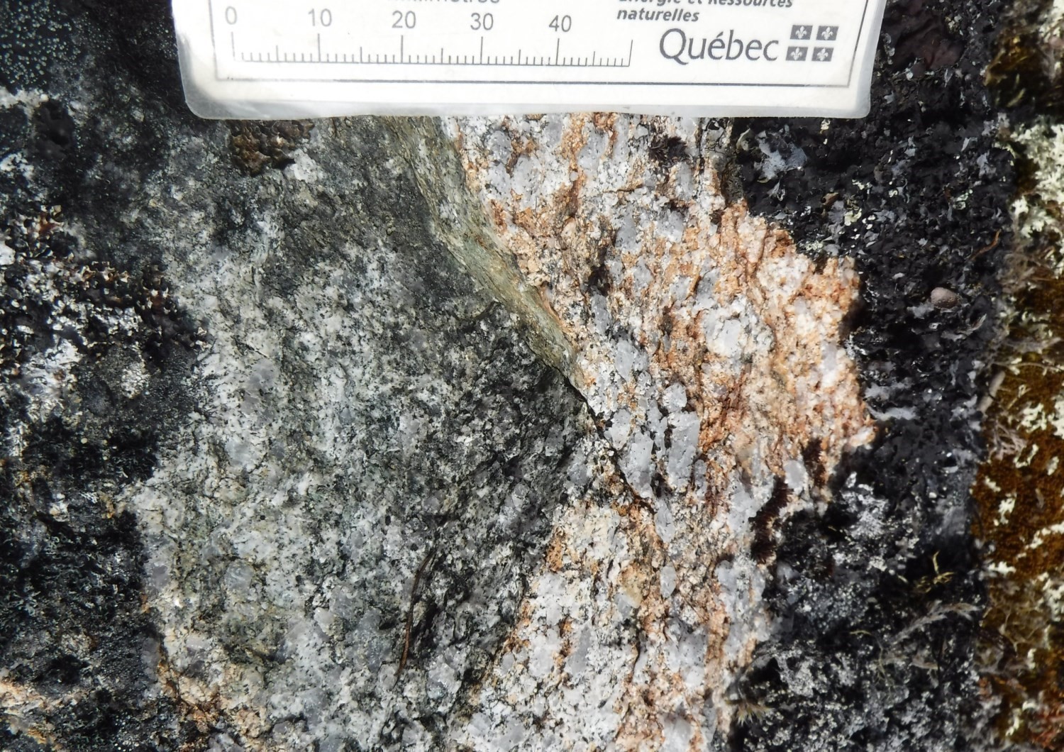
The Sanimuapik Suite (pPsak) is a new unit of blue quartz tonalite intruding into volcanic rocks of the Parent Group. It has been dated 1898 Ma (Parrish, 1989) and 1894 ±5 Ma (Davis, in preparation).
The Iqiat Suite (pPiqa) is introduced to group heterogeneous gabbro and diorite intrusions emplaced in volcanic rocks of the Parent Group. This unit cuts the Sanimuapik Suite.
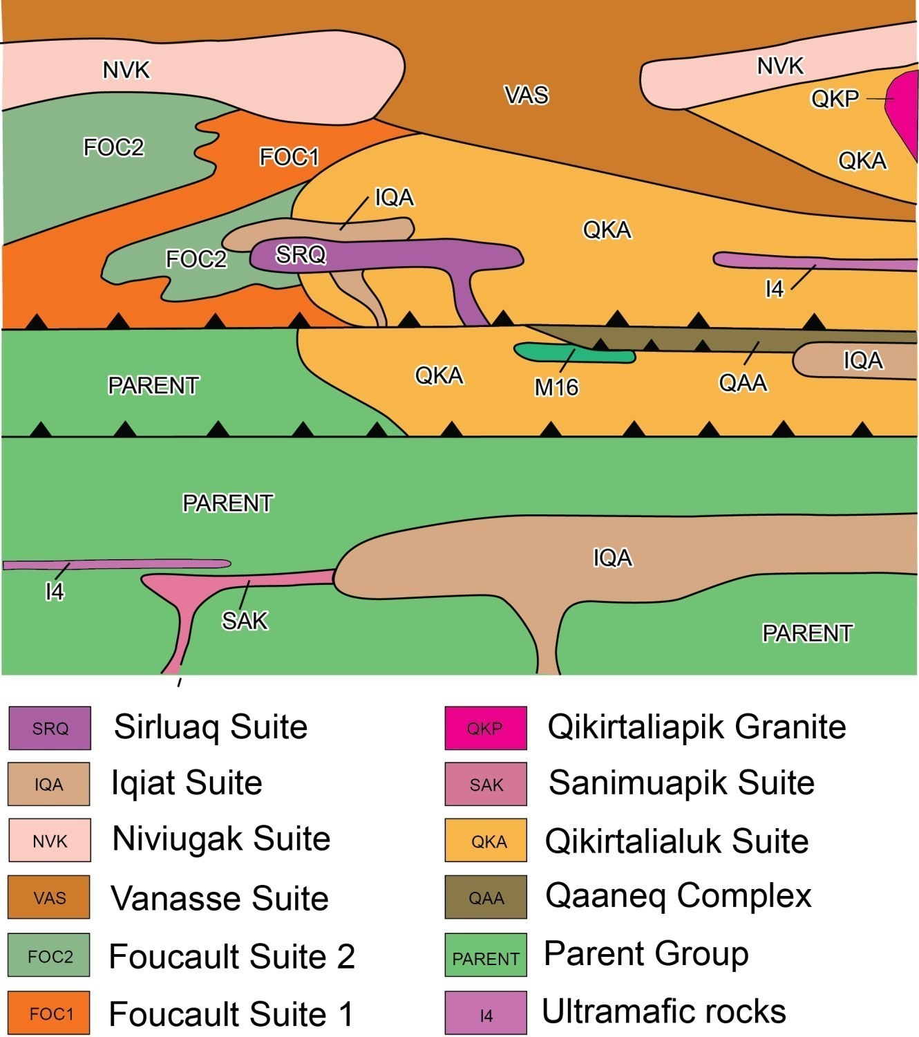
Northern Part
Metamorphic Rocks
The Foucault Suite (pPfoc) is introduced to group banded and recrystallized gabbro and diorite units of the NW area of the map. The protolith of these rocks is unknown. The transitional calc-alkaline geochemical affinity of the hornblende porphyritic unit (pPfoc2) is similar to that of the hornblende-plagioclase porphyritic volcanic rocks of the Parent Group (pPpa10c). Sample 19-GM-5107-A was dated 1854 ±3 Ma (Davis, in preparation).
The Qaaneq Complex (pPqaa) consists of a sequence of metawacke and meta-arenite layers. The composition of this unit is interpreted as a metamorphosed turbiditic sequence resulting from the erosion of mafic rocks. This complex is in fault contact with gabbros of the Qikirtalialuk Suite (pPqka), as well as with other mafic plutonic units in the north-central part of the study area.
Intrusive Rocks
The Qikirtalialuk Suite (pPqka) is a new suite consisting of heterogeneous, locally layered gabbro outcropping in the NE part of the mapped area. This suite is in intrusive contact with volcanic rocks of the Parent Group and possibly with the Qaaneq Metasedimentary Complex. The Qiirtalialuk Complex is cut by rocks of the Foucault Suite. Geochemical data analysis allowed identifying intrusions of the Qikirtalialuk Suite in the NW part of the study area. A very coarse gabbro sample (19-GM-5201-A) was dated 1899 ±3 Ma (Davis, in preparation).
The Vanasse Suite (pPvas) is a new fairly homogeneous and not very deformed unit consisting of gabbro and gabbronorite. This suite has a tholeiitic geochemical affinity and cuts all the surrounding units except for speckled quartz diorite of the Niviugak Suite (pPnvk). This unit is distinguished from intrusive rocks of the Vanasse Suite by its characteristic calc-alkaline affinity. The Niviugak Suite also cuts the Foucault and Qikirtalialuk suites.
The Qikirtaliapik Granite (pPqkp) is a new lithodeme consisting of white garnet granite that intrudes into gabbros of the Qikirtalialuk Suite. Located at the northern edge of the map, a tonalite dated 1870 Ma (Parrish, 1989) could be part of this unit.
The Sirluaq Suite (pPsrq) is a new unit of massive gabbro and gabbronorite forming small plutons in the western part of the mapped area. It cuts the Foucault and Qikirtalialuk suites.
Lithogeochemistry
The lithogeochemistry of units in the Parent Lake area is presented separately in tabular form.
Structural Geology

Geological mapping and analysis of structural data collected on the Parent Lake territory in the summer of 2019 identified primary fabrics, two deformation phases and six structural domains.
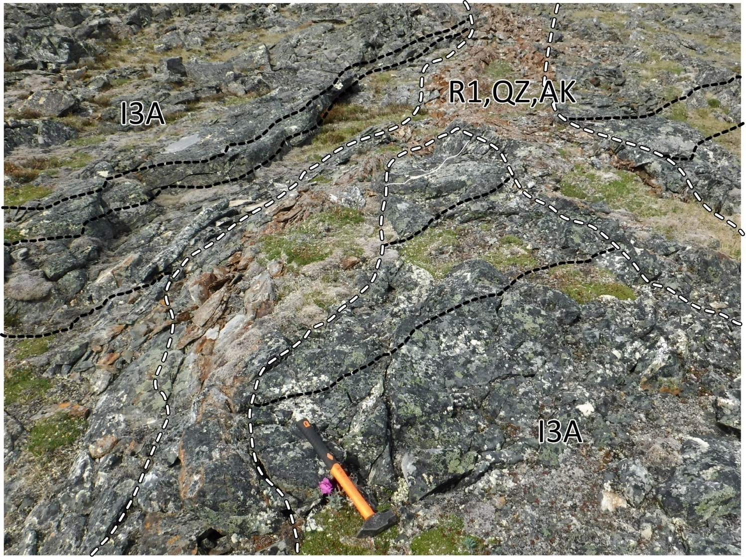
Deformation D1 is responsible for the formation of ENE-WSW oriented P1 folds with axial planes overturned towards the SSE, and then thrust faults F1 of the same orientation and SSE vergence. Phase D1 affects the entire area except for the NW zone. This zone is affected by a distinct deformation phase, D2, associated with SE thrusting of plutonic units on volcano-sedimentary rocks of the Parent Group. Planar and linear fabrics are associated with each of the two phases. The domains constitute coherent structural ensembles, considering both their structural and lithostratigraphic characteristics. The following numbering is used to designate the Chukotat (I), Qitequt (II), Parent (III), Amiq (IV), Qikirtalialuk (V) and Vanasse (VI) domains.
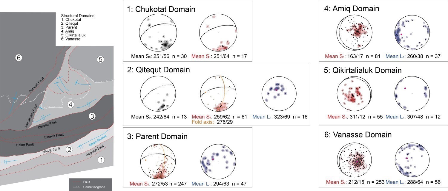
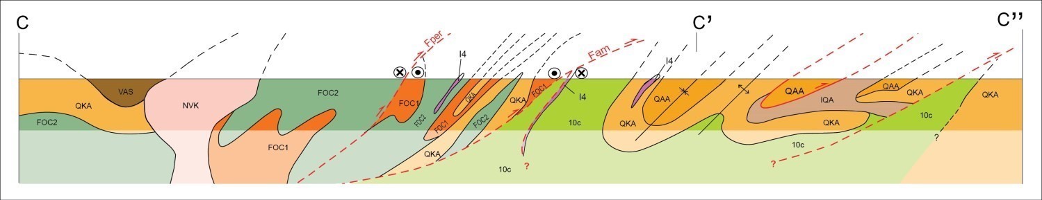
Chukotat Structural Domain (I)
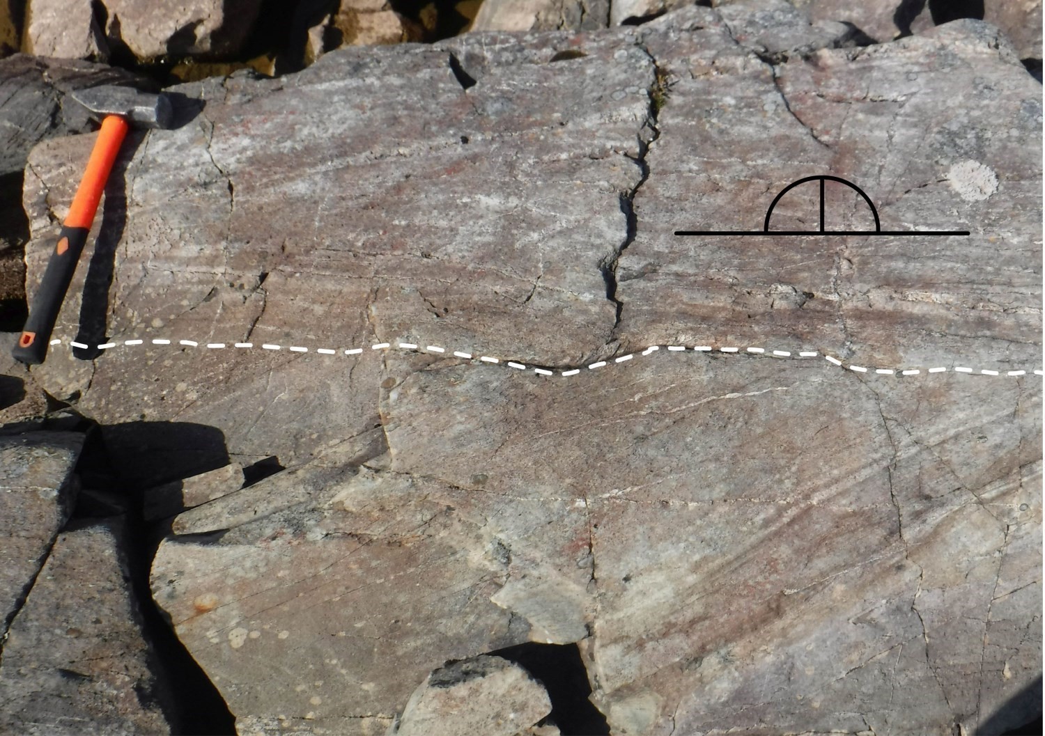
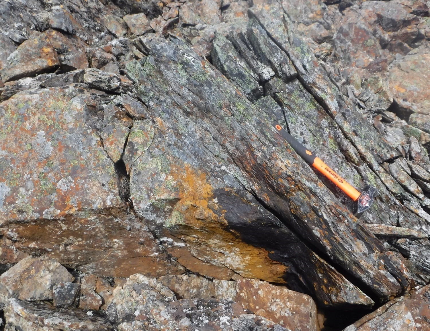
The Chukotat Domain corresponds to the lithotectonic domain of the Ungava Orogen Southern Domain. It consists of a homogeneous block with very few lithological variations, largely dominated by sequences of pillow basalts and mafic sills. Primary structures of volcanic origin, such as pillow peduncles and quartz chambers, are well preserved. These allow a normal stratigraphic polarity to be determined around 341°. Only a single, very weak D1 deformation phase can be recognized in the Chukotat Domain. Flattened pillows were observed and, locally, an average schistosity S1 oriented 252°/65°, subparallel to bedding S0 oriented 251°/56°. According to the results of previous work, the Chukotat Domain is cut by a generation of thrust faults F1. The Bergeron Fault marks the northern boundary of the domain and corresponds to the contact between the Chukotat and Parent groups. On outcrops, mineral lineations L1 are observed down dip, locally subhorizontal, as well as C/S fabrics, small brecciated corridors and a generalized hematitization of rocks of certain parts of the fault wall. Its play is interpreted as reverse thrusting with a minor sinistral strike-slip component. There is a preserved layer of conglomerate and stratified red arenite beds belonging to the Hubert Formation (pPhbt), which is unconformably (angular) deposited on basalt of the Chukotat Group. These rocks are cut to the north by the Bergeron Fault and to the west by a NW-SE geophysical lineament interpreted as an early fault or flexure cut by F1 faults.
Qitequt Structural Domain (II)
The Qitequt Domain is located in the extreme south of the Parent Group. It straddles the Chukotat Domain along the Bergeron Fault; to the north, it is straddled by the Parent Domain (III) along the Mivvik Fault. It consists mainly of extrusive and pyroclastic volcanic rocks, while exhibiting several primary volcanic structures preserved in the NW part of the domain. The peduncles of basaltic pillows, as well as oblique beds and sorting in ash tuff, allow determining stratigraphic polarities of NNW orientation in this part of the domain. The volcanic sequence contains two beds of pyrrhotite mudrock (pPpa14), the lateral extensions of which have been recognized on aeromagnetic and electromagnetic maps (Fiset, 2004). These beds are marker layers that allow distinguishing the Qitequt Fold, an isoclinal structure formed by two hinges shallowly dipping westward, occupying the entire domain. The geometry of the western hinge of this fold was determined from measurements of stratigraphic polarity and that of the eastern hinge by extrapolation of measurements obtained and by following the mudrock marker layers on the map. The fold is characterized by a syncline synform hinge plunging towards the WSW in the eastern part of the domain and an anticline antiform hinge plunging towards the WSW in the western part. A S1 fabric identified as an axial plane schistosity cuts tuff bedding in the western hinge. This schistosity is transposed to the stratification on the flanks of the fold forming a S0-S1 composite fabric. The attitude of this fabric on each of the fold flanks indicates overturning of the Qitequt structure towards the SSE. Aeromagnetic maps (Intissar et al., 2014) indicate that the ridges of highest magnetic susceptibility represent the lithological contrasts and, by extension, the S0-S1 composite fabric, truncated by the Bergeron and Mivvik thrust faults. Outcrops in the vicinity of the Mivvik Fault show textures such as sigmoids and shear bands indicating a dextral strike-slip component. On aeromagnetic maps, truncations of positive anomaly ridges allow recognizing the crosscutting of lithological contacts by the Mivvik Fault, as well as P1 folds, schistosity S1 and the northern flank of the Qitequt fold.
Parent Structural Domain (III)
The Parent Domain consists of volcano-sedimentary terrains belonging to the Parent Group (pPpa) that is cut by intrusions of the Sanimuapik (pPsak) and Iqiat (pPiqa) suites. This domain straddles the Qitequt Domain (II) to the south along the Mivvik and Esker faults; to the north, it is straddled by the Amiq Domain (IV) along the Belleau Fault. The three faults are SE to SSE verging. The Parent Domain is affected by deformation phase D1, expressed by a schistosity S1 measured on almost all the volcano-sedimentary rock outcrops, and marked by a foliation of the same generation in intrusive units. The stereographic projection of S1 measurements reveals an average attitude of 272°/53°. An average fold axis of 277°/30° is obtained from the pole of a great circle connecting poles of S1 measurements. The attitude of this axis is consistent with the 276°/29° attitude obtained in the Qitequt Domain (II). On the other hand, no fold hinge has been recognized at the scale of the map in the Parent Domain. Volcanic and intrusive units are cut by the Qiqaviq Thrust Fault in the middle of the domain. Like other thrust faults in the half-south of the mapped area, the Qiqaviq Fault was identified from measurements of mineral stretch lineations L1 down dip of S1, local increase in the rate of rock deformation to slate flow, the presence of widespread ankeritization and the appearance of quartz vein swarms. The Qiqaviq Fault was formed in the middle of a symmetrical repetition of units pPpa10c and pPpa12. This geometry suggests the entrenchment of a possible synclinal fold hinge caused by thrusting of the Qiqaviq Fault. The fold axial plane would be occupied by tonalite (pPsak) and gabbro (pPiqa) intrusions. In the field, the Esker and Qiqaviq F1 faults are identified by the slate flow of rocks locally observed in the roof of the faults. This flow gradually intensifies as it approaches the core of the structure. In addition, the presence of mineral lineation L1 down dip of the S1 plane in highly deformed zones indicates a reverse thrust movement of SSE vergence.
Amiq Structural Domain (IV)
The Amiq Structural Domain occupies the north-central part of the area. Its lithological succession includes units of the northern part of the Parent Group (pPpa) and metasedimentary rocks of the Qaaneq Complex (pPqaa). This domain overthrusts the Parent Structural Domain (III) to the south, along the Belleau Fault; to the NW it is overthrusted by the Vanasse Domain (VI), along the Ammaluttuq Deformation Zone. Rocks are marked by a schistosity or a penetrative foliation S1. The projection of measurements on the stereogram reveals a variable orientation of S1 and a generally average shallow dip of 163°/17°. This contrasts with the schistosity of constant attitude estimated at 268°/56° for the Parent (III), Qitequt (II) and Chukotat (I) structural domains further south. The variations in attitude of S1 on the stereogram and the geological map reveal the structural complexities specific to the different parts of the domain. Locally, lithological contacts between metawackes and arenitic layers are observed in the Qaaneq Complex (pPqaa). This bedding S0 is transposed to schistosity S1, forming a S0-S1 composite fabric. No fabrics cut S1 or the S0-S1 composite fabric. S1 is interpreted as an axial schistosity in volcanic units of the southern part of the domain. Lithological repetitions allow us to recognize an anticlinal antiform hinge of an isoclinal P1 fold overturned towards the SSE, a geometry similar to that of the Qitequt Fold (II). The western end of this axial trace is picked up by a fold resulting from a later deformation phase D2, which is associated with thrusting of the Vanasse Domain (VI) on the Amiq Domain. This P2 fold is defined as an open, synformal synclinal structure, slightly inclined towards the SE and with an axis slightly plunging towards the NE. The folds in the northern part of the domain are of greater amplitude, more upright, open and having NW-SE to WNW-ESE axial traces. This geometry is attributed to shallow dips of schistosity S1 and composite fabric S0-S1 in the area. The Amiq Domain also differs from domains I, II and III by the ubiquity of mineral lineations L1 having an average attitude of 265°/41°. This fabric gradually changes from a NW-SE orientation in the western part of the domain to a SW orientation in the eastern part. This trajectory is consistent with the curvature of the axial traces of P1 folds in the area and that of the synform-folded thrust fault under the Qaaneq Complex. This local basin structure suggests the existence of a very late, large amplitude E-W undulating folding event, as interpreted in the Watts Lake area (Mathieu and Beaudette, 2019).
Qikirtalialuk Structural Domain (V)
The Qikirtalialuk Structural Domain is located in the NE part of the mapped area, in intrusive contact with the Amiq Structural Domain (IV). It consists mainly of gabbro and ultramafic rocks of the Qikirtalialuk Suite (pPqka). Resistant to deformation, it forms an isotropic and rigid block that is not cut by any thrust fault or shear zone. Primary structures are locally observed, such as compositional bedding of magmatic origin and cumulate layers. Some outcrops are marked by a foliation S1, defined by the preferential orientation of hornblende and plagioclase crystals. In stereographic projection, measurements are globally distributed on a mean great circle oriented 311°/12°. There are two groups having a majority of planes oriented NW and others oriented SE, indicating the potential presence of folds having NW-SE axial traces. Some outcrops in the western half of the domain are marked by a mineral lineation L1 having an average attitude of 307°/48°. On the map, orientations of this lineation are consistent with those of the NE part of the adjoining Amiq Domain (IV), indicating a certain continuity of the structural grain between the two domains.
Vanasse Structural Domain (VI)
The Vanasse Structural Domain consists of a large package of plutonic and metamorphic units located in the NW part of the mapped area. The domain overthrusts those of Parent (III) and Amiq (IV), along the Ammaluttuq Deformation Zone. Thrusting is associated with deformation phase D2. This phase of deformation is distinct from phase D1, particularly in view of the evidence of crosscutting of the regional aeromagnetic grain by that of the Vanasse Domain. The transition is also marked by the sudden transition from the sequence of plutonic units of the Vanasse Suite, some of which are granoblastic and gneissic (Foucault Suite), to volcano-sedimentary schists of the Parent and Amiq domains.
Units of the Vanasse Domain are affected by a foliation S2 of average attitude 212°/15, associated with a NW-SE shortening. Rare P2 foliation hinges oriented NE-SW have been interpreted, including a synformal syncline structure having very shallow plunge towards the NE in the northern part of the Parent Group, in the wall of the thrust front. This front is materialized by a kilometre-thick NE-SW deformation zone, bounded to the SE by the Ammaluttuq fault and to the NW by the Perrault fault. Their respective kinematics were determined from C/S fabrics and the rotational direction of garnet porphyroblasts observed in mylonitic zones, as well as by the attitude of two families of mineral lineations L2. The trace of the Ammaluttuq Fault is established from the truncations of anomalous ridges on the aeromagnetic map. Some outcrops display a subhorizontal lineation indicating a sinistral strike-slip movement and a few rare down-dip fabrics of S2 indicating reverse thrusting. Kinematic indicators and lineations associated with the Perrault Fault reveal a single movement component of dextral strike-slip. On aeromagnetic maps, the Perrault Fault cuts the structural grain of the area, representing regional foliation S2. The thrust and shortening phase is therefore prior to the strike-slip event.
Metamorphism
The metamorphic context of the Parent Lake area was defined based on field observations made in the summer of 2019 and samples studied under the microscope. The metamorphic gradient gradually increases from south to north. The area is divided into two metamorphic domains delineated in the central part of the area by the garnet isograde oriented ESE-WNW. This isograde was first defined by Hervet (1984) and then traced within the Amiq Structural Domain using field data from the summer of 2019. The southern half of the area evolves from the lower greenschist facies to the upper greenschist facies. The northern half is metamorphosed from the upper greenschist facies to the mid amphibolite facies.
Southern Part of the Parent Lake Area
The southern part of the area consists mainly of mafic volcanic rocks of the Chukotat (pPch) and Parent (pPpa) groups. Although there is a great diversity of lithologies and structures, mineralogical assemblages vary very little. Globally, the assemblage consists of actinolite-plagioclase-epidote ± chlorite ± carbonate ± quartz, characteristic of the lower greenschist facies. Epidote partially to totally replaces plagioclase. Actinolite crystals and chlorite clusters are aligned in the plane of the main schistosity. As for porphyritic volcanic rocks, pyroxene phenocrystals are replaced by amphiboles and epidote, and olivine phenocrystals by serpentine and carbonate. Primary minerals are recognized in the partially preserved cores of some phenocrystals.
Gélinas (1961) mentions that phyllites of the Spartan Group in the eastern part of the Northern Domain (sheet 35G16) are composed of muscovite and traces of biotite. The apparition of biotite indicates upper greenschist facies prograde metamorphism. The Spartan Group does not outcrop in the Parent Lake area. The unit changes laterally to volcanic units composed of chlorite and not biotite. The biotite isograde is therefore not recognized in the area.
Northern Part of the Parent Lake Area
The northern part of the area consists mainly of plagioclase-hornblende ± garnet gabbro units, an assemblage characteristic of the amphibolite facies. Garnet forms subhedral porphyroblasts cutting the main foliation, some of which show a slight rotation, indicating late-kinematic crystallization. These rocks are associated with metasedimentary rocks of the Qaaneq Complex. They include a plagioclase-quartz-amphibole-garnet-biotite-muscovite assemblage characteristic of the mid amphibolite facies (St-Onge et Lucas, 1993). Staurolite was observed in a single sample, which supports this hypothesis. The muscovite crystallization conditions and the absence of sillimanite indicate temperatures below 500°C.
Roof rocks of the Ammaluttuq Deformation Zone (Vanasse Structural Domain), especially those of the Foucault Suite, are banded, granoblastic and locally gneissic. Their plagioclase-hornblende ± garnet ± quartz assemblages do not allow the pressure and temperature conditions of formation to be defined. In thin sections, the chessboard extinction and edge migration of quartz and plagioclase crystals observed in some samples indicate amphibolite facies metamorphic conditions. Some facies of the Foucault Suite contain quartzofeldspathic bands resembling migmatitic mobilisate. In the NW part of the area, orthopyroxene visible in gabbronorite of the Vanasse (pPvas), Niviugak (pPnvk) and Sirluaq (pPsrq) suites is interpreted as being of primary origin, which excludes the hypothesis of a post-magmatic replacement at the granulite facies.
Retrograde Metamorphism
The coronitic texture of garnet porphyroblasts and the replacement of hornblende by actinolite clusters cutting foliation suggest an episode of post-kinematic retrograde metamorphism in the northern part of the area. Garnet is either partially to completely replaced by chlorite, or has epidote-quartz ± chlorite rims, especially in gabbro layers of the Qikirtalialuk Suite (pPqka). There are also plagioclase rims around garnets in banded rocks of the Foucault Suite (pPfoc), indicating a decrease in lithostatic pressure in the roof of the Ammaluttuq Thrust Zone.
In the southern part of the area, the wall of the Bergeron Fault includes cataclastic rocks and zones marked by widespread hematitization. Metasomatic activity is also expressed by ankeritization present along the Mivvik and Qiqaviq faults. These observations confirm the retrograde nature of deformation at the greenschist facies, even at lower temperature conditions.
Economic Geology
The Parent Lake area comprises prospective zones for six types of mineralization:
- Native copper mineralization at the Hubert-Chukotat unconformity;
-
Lode gold mineralization related to ankerite alteration and anomalous arsenic contents associated with internal and peripheral deformation zones of Qikirtalialuk Suite gabbros;
-
Cu-Au-Ag mineralization associated with quartz veins;
-
Au ± Ag ± Cu ± Zn mineralization associated with shear zones and intermediate to felsic syn-kinematic intrusive rocks in the Parent Group;
-
Exhalative sulphide mineralization in the Parent Group;
-
Magmatic and hydrothermal Cu-Ni-PGE mineralization in the Chukotat Group;
The table of mineralized zones below presents analytical results for the 12 known mineralized zones in the area, including one new mineralized zone discovered during our work.
| Name | Contents | |
|---|---|---|
| Stratiform Copper Mineralization in Sedimentary Rocks | ||
| Dryade | 18 800 ppm Cu (G); 9 ppm Ag (G) | |
| Name | Contents | |
|---|---|---|
| Magmatic and Hydrothermal Cu-Ni-PGE Mineralization | ||
| Lac Ekwan (Zone A) | 11 400 ppm Ni (G); 12 235 ppm Cu (G); 1900 ppb Pd (G); 484 ppb Pt (G); 4200 ppm Cr (G) | |
| Lac Ekwan (Zone B) | 8991 ppm Ni (G); 5818 ppm Cu (G); 2030 ppb Pd (G); 378 ppb Pt (G) | |
| Magmatic Ni-Cu (± Co ± PGE) Mineralization | ||
| Lac Ekwan (Zone C) | 15 600 ppm Ni over 13 m (D); 13 000 ppm Cu over 13 m (D); 350 ppb Pt (G); 450 ppb Pd (G) | |
| Mineralization of Common Metal Massive Sulphides Associated with Volcanic Rocks (VMS) | ||
| Goshawk Sud | 31 700 ppm Cu (G); 1160 ppb Au (G); 34 ppm Ag (G) | |
| Mineralization of Undetermined Type | ||
| Gerfaut-1 | 1800 ppb Au (G) | |
| Goshawk | 3080 ppb Au over 10.5 m (D); 35 500 ppm Zn (G); 15 272 ppm Cu (G); 7004 ppm Pb (G); 20.02 ppm Ag (G) | |
| Goshawk Ouest | 14 300 ppb Au (G) | |
| KOR-2 | 38 800 ppm Cu (G); 13.15 ppm Ag (G) | |
| Kahuna | 16 550 ppm Cu (G); 16.25 ppm Ag (G) | |
| Nanuq-2 | 20 600 ppm Cu (G); 389 ppb Au (G) | |
| Nanuq-3 | 28 000 ppm Cu (G) | |
| Roy No 1 | 50 ppm Ag (G); 2100 ppm Zn (G); 330 ppb Pt (G) | |
(D): Diamond drilling; (G): Selected sample
The table of lithogeochemical analyses of metals of economic interest provides the location, description and analytical results for 238 selected samples in order to evaluate the economic potential of the area.
Known Mineralization in the Study Area
Magmatic and Hydrothermal Cu-Ni-PGE Mineralization in the Chukotat Group
The first chalcopyrite and pentlandite mineralized zones were observed as early as the 1930s in the Ungava Trough. However, the potential for Cu-Ni mineralization in the Cape Smith Belt was reported by Bergeron (1957) following the first systematic exploration campaigns in the area, and the discovery of the Raglan Mine (Katinniq) deposit by Harold Kenty and his team. Subsequent discoveries of Ni-Cu-(Co-PGE) deposits such as Expo (Ungava), Méquillon, Allamaq, Raglan (Donaldson), followed by the start-up of the Raglan (1998) and Nunavik Nickel (2013) mines confirm the economic importance of magmatic mineralization in the Cape Smith Belt. The mineralization forms lenses and dissemination of sulphides concentrated at the base of differentiated mafic to ultramafic sills of the Lac Esker Suite, which are hosted in sedimentary rocks of the Nuvilic Formation.
 In the southern part of the mapped area, a differentiated gabbro dyke intruding into olivine basalt of the Chukotat Group hosts the Lac Ekwan (Zone A), Lac Ekwan (Zone B) and Lac Ekwan (Zone C) mineralized zones. To the east, a subophitic gabbro sampled mineralized in primary pyrrhotite was collected on outcrop 19-SM-6185, which is in the stratigraphic continuity of known mineralized zones.
Mineralization Little Known or Discovered During the Present Work
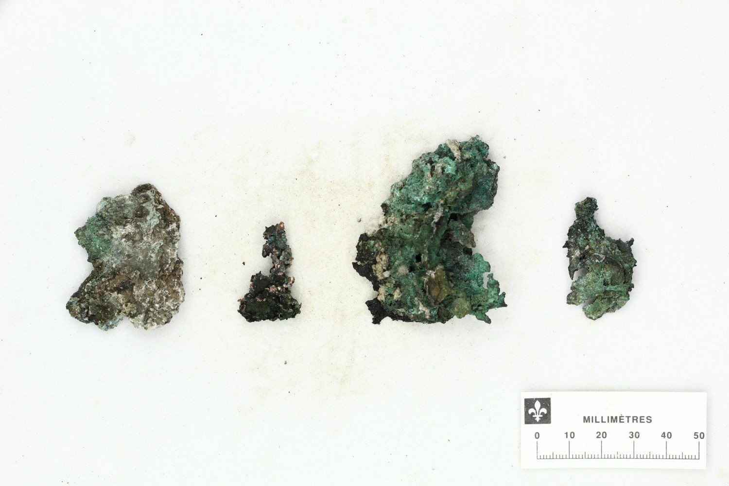
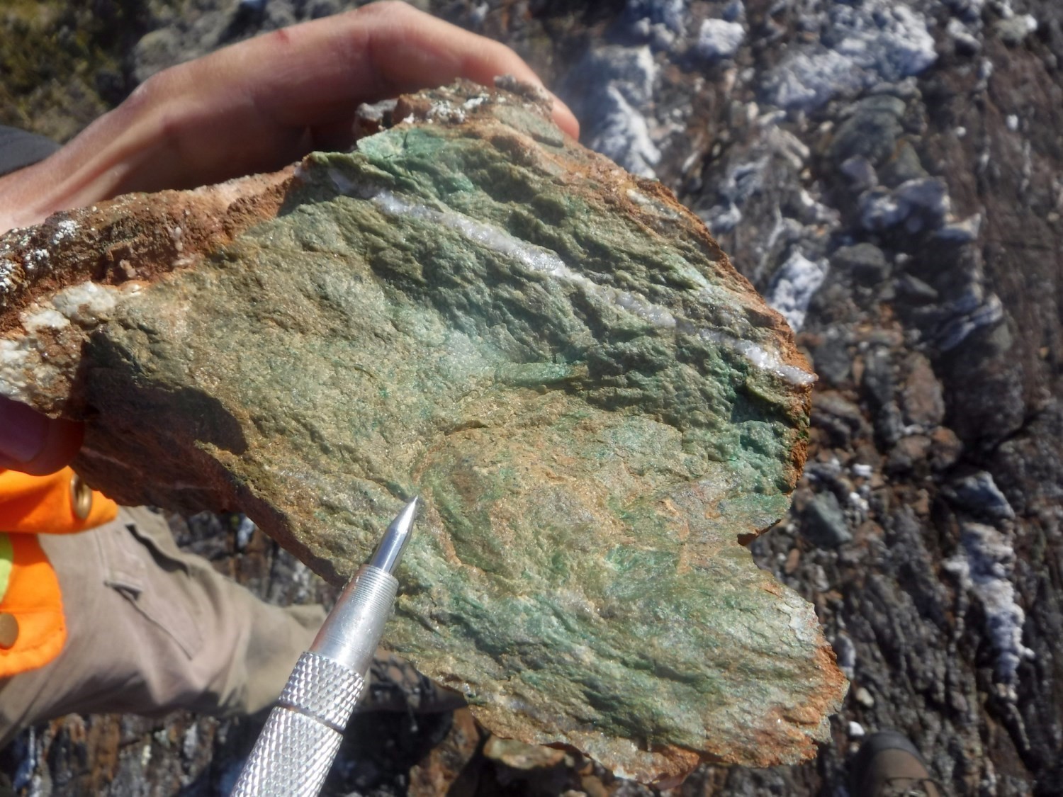
New Native Copper Mineralization at the Hubert-Chukotat Unconformity

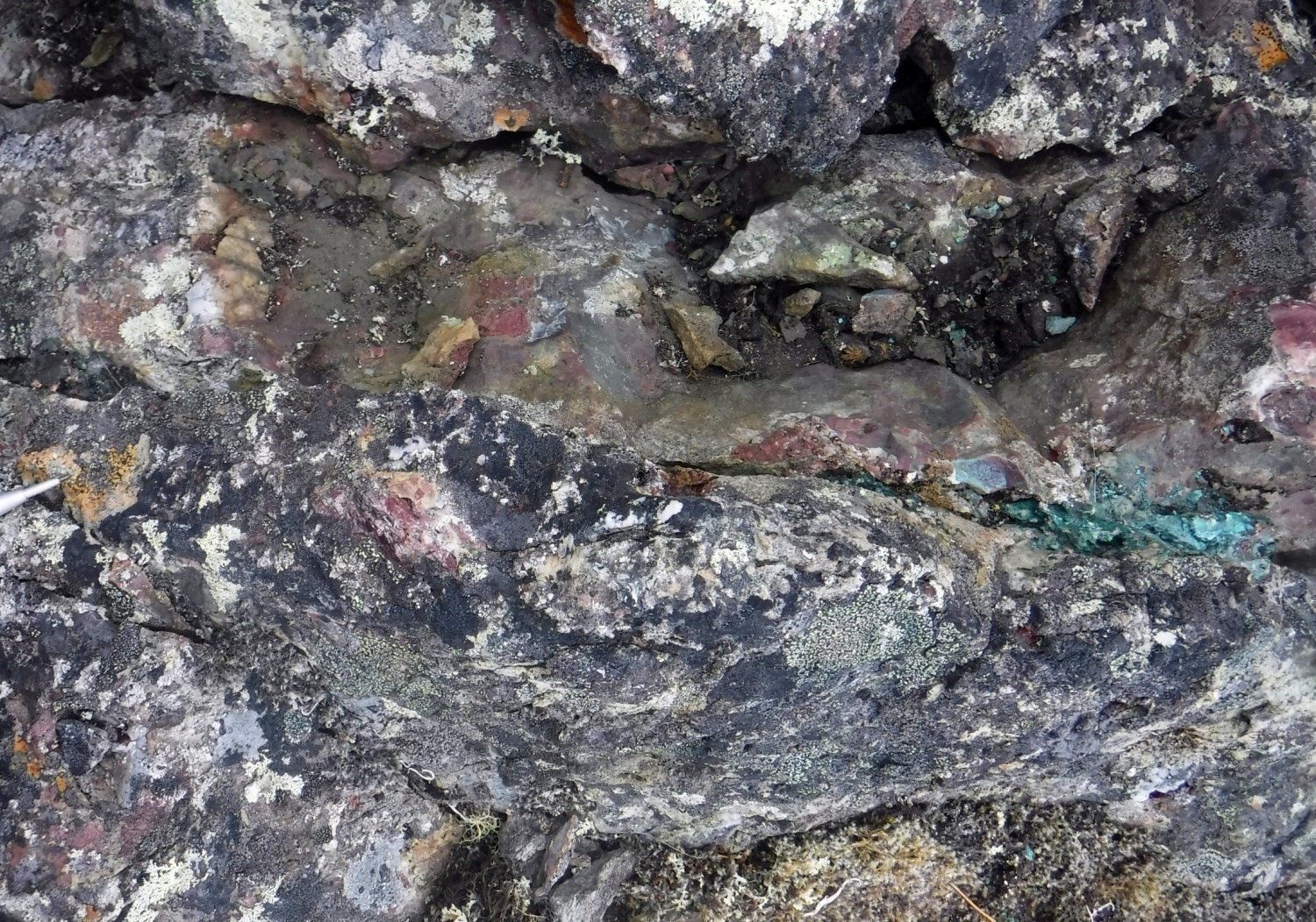
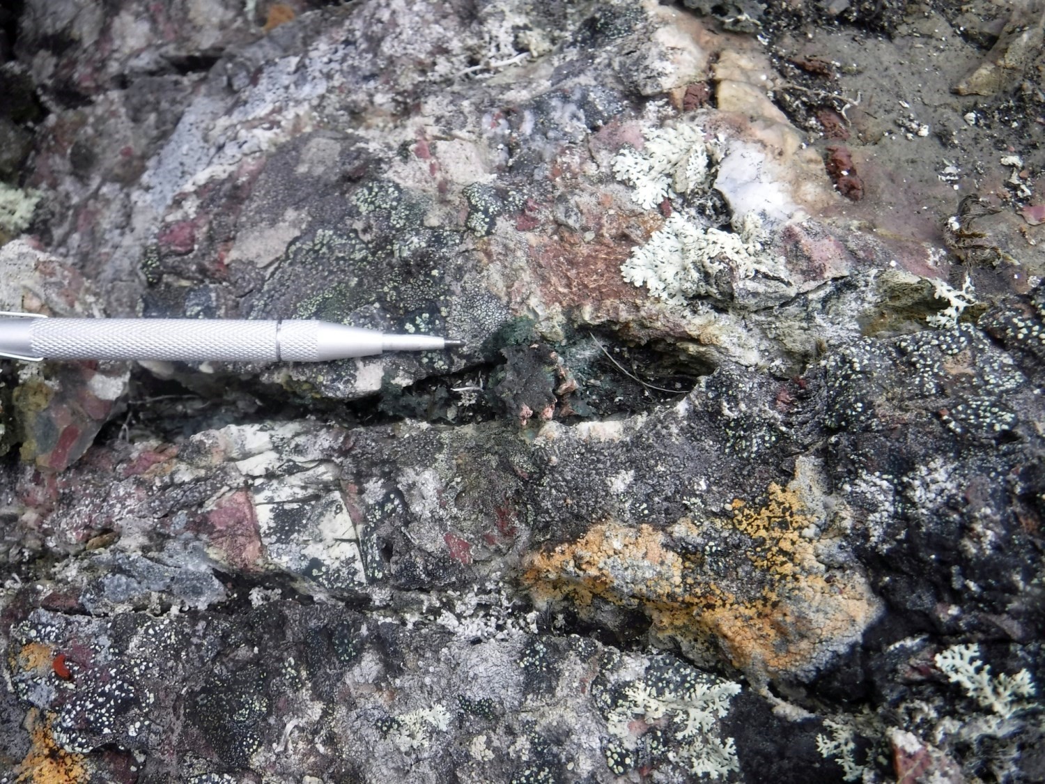
Mapping work in the summer of 2019 led to the discovery of copper vein mineralization associated with the angular discordance between pillow basalts of the Chukotat Group and polymictic conglomerate unit of the Hubert Formation. Mineralization occurs as centimetric veins composed of native copper, malachite and azurite. The vein is located on the Dryade mineralized zone and cuts the stratification and main schistosity. It is visible over at least 0.5 m in hematitized conglomerate near the contact with basalt. The latter is also hematitized, epidotized and chloritized. A selected sample from the vein yielded contents of 1.88% Cu and 9 g/t Ag. A prospective zone named Hubert was thus defined (see interactive map).
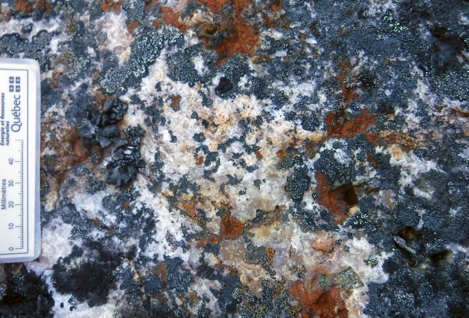
Lode Gold Mineralization Related to Ankerite Alteration and Anomalous Arsenic Contents Associated with Internal and Peripheral Deformation Zones of Qikirtalialuk Suite Gabbros
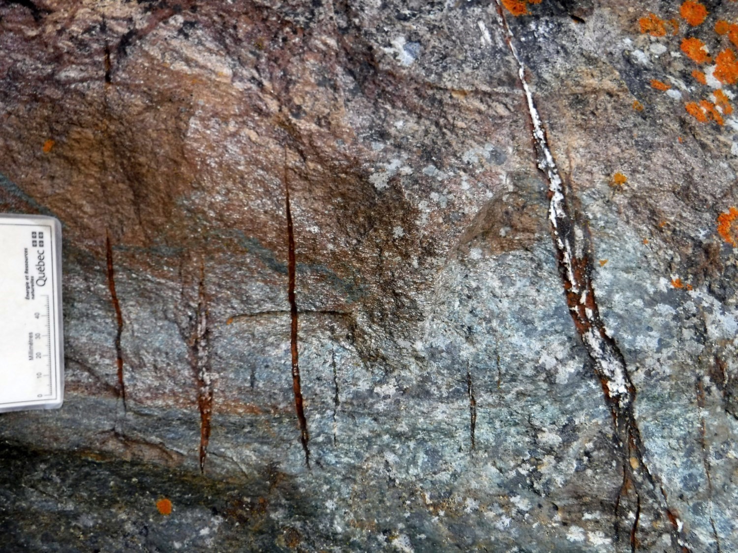
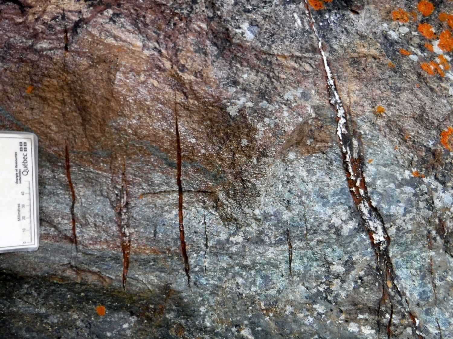
This new type of mineralization in the area was uncovered from anomalous arsenic values obtained from systematic pXRF analyses. Mineralized zones have been described in the field as metasomatic alteration corridors associated with secondary fractures and located in shear zones of variable thickness and up to 350 m. These rocks are derived from protoliths including diorite, mafic to ultramafic intrusive rocks and lesser amounts of metamorphosed mafic volcanic rocks. Metasomatized zones form subparallel compositional bands (30 cm to 2 m thick) that vary according to the alteration intensity and are characterized by diffuse carbonatization (ankeritization). Mineralization is in the form of generally euhedral pyrite (<3%) disseminated in quartz veins (1-30 cm) having a saccaroidal and laminated texture. The veins contain ankerite clusters and bands and, locally calcite, chlorite, hematite and fuschite. A new sample from a quartz-ankerite-pyrite vein collected on outcrop 19-CB-1017, yielded contents of 253 ppb Au and 146 ppm Cu. A prospective zone named Qikirtalialuk was defined (see interactive map).
Cu-Au-Ag Mineralization Associated With Quartz Veins
This type of mineralization was discovered from anomalous copper contents in lake bottom sediments (Maurice and Lamothe, 2012). A short exploration campaign led to the discovery of quartz veins mineralized in copper, some of which in gold and silver, associated with rocks interpreted as sheared gabbros. The best values obtained from this exploration program are 35.4 g/t Au, 38.9 g/t Ag and 0.1% Cu (Allard, 2014). Mapping work in the summer of 2019 led to the discovery of quartz veins in a similar context and in the southern extension of historical mineralized zones. Veins are of variable thickness (10-70 cm) and cut host units (Vanasse, Foucault and Niviugak suites) without any preferential orientation. Mineralization is contained in disseminated clusters (1 mm to 2 cm) of subhedral to euhedral pyrite, locally accompanied by subhedral pyrrhotite and chalcopyrite. Vein gangue minerals include calcite, chlorite and malachite. The host rock is characterized by little or no alteration, with the exception of slight hematitization associated with late fractures covered with pyrrhotite. The Foucault prospective zone was created for this type of mineralization (see interactive map).
Au ± Ag ± Cu ± Zn Mineralization Associated with Shear Zones and Intermediate to Felsic Syn-Kinematic Intrusive Rocks in the Parent Group
Au ± Ag ± Cu mineralization is associated with quartz veins concentrated in secondary shear zones. These are on the margin of gabbroic to granitic intrusions of the Sanimuapik and Iqiat suites. The shear zones are associated with the Qiqaviq and Esker faults, essentially E-W trending, with an ENE inflection in the eastern section of the map. These zones also cross mafic volcaniclastics and sedimentary rocks, both hosting local sulphide clusters. They correspond to conductive anomalies and As-Bi-Sb-W anomalies in till (Cloutier et al., 2018). The length of intrusions varies from 600 m to 6 km. Several mineralized boulders, located near the contact with intrusions, yielded 5.22 g/t Au to 189 g/t Au and a point value of 457 g/t Au (Cloutier et al., 2018). In situ mineralization is characterized by host rock alteration including silicification, diffuse carbonization (dolomitization and ankeritization) and potassic alteration of pyroclastic units (pPpa). The mineralization context is similar to a model of orogenic gold and metamorphosed mineralization associated with a polymetallic gold epithermal system. One prospective zone proximal to an intrusion (Qiqaviq) and two other epithermal gold-bearing prospective zones (Esker-1 and Esker-2) were defined (see interactive map).
Exhalative Sulphide Mineralization in the Parent Group
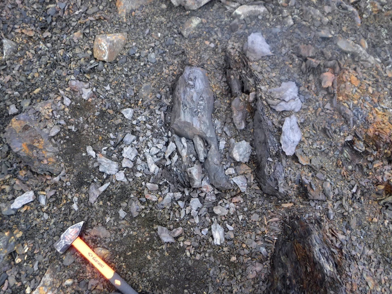
Known lenses of exhalative sulphides have been identified following a ground geophysical campaign and through electromagnetic anomalies in cherty layers interstratified in the basaltic sequence of the Parent Group. Some of these lenses host copper-zinc mineralization (KOR-2 mineralized zone). Local remobilization of sulphides in deformed zones is associated with significant gold and silver values (Kahuna, Goshawk and Goshawk Ouest mineralized zones). The more altered zones appear to contain higher zinc contents, with results ranging from 0.11% Zn to 0.4% Zn (Jourdain, 1998). Massive sulphide clusters (10 cm to 2 m thick) generally alternate with layers of epidotized and chloritized basalt, mafic schist and locally graphitic mudrock. Sulphides account for 5% to 60% of the sample volume and the main phases encountered are pyrite and pyrrhotite, with smaller and variable amounts of chalcopyrite and bornite. Mineralization is also associated with zones of disseminated pyrite (± arsenopyrite) altered to silica. Several outcrops have sulphide concentrated in late veinlets and in brecciated layers. Remobilization indicates polyphase genesis of such mineralization (Giovenazzo, 1997). Four prospective zones have been defined (see interactive map): Parent-1, Parent-2, Parent-3 and Parent-4.
Issues for Future Work
The issues raised by the detailed mapping of sheet 35G11 are mainly stratigraphic in nature. It is necessary to refine the stratigraphy of the Parent Group using lithogeochemistry and to better constrain marker layers (Mélanie Beaudette, master’s project in progress). Metasedimentary rocks of the area seem to occupy a different stratigraphic position than those of the Spartan Group, mapped further east in 2018. Their affinity remains to be specified, as well as their structural relationship with the Foucault and Qikirtalialuk suites, which are probably the oldest units in this zone.
The 2020 campaign, with the coverage of sheet 35G10, will allow to complete mapping at scale 1:50 000 of the eastern half of the Northern Domain. This area will allow elucidating the relationship between mafic and ultramafic units of the Watts Group, outcropping in the extreme east of the Domain, and the succession of diorite and gabbro units predominating in this area. An in-depth study of the geochemical and geochronological data will enable each of the mafic intrusive units to be adequately defined (Sacha Lafrance, PhD project in progress).
Finally, the new types of vein mineralization uncovered in 2019, as well as the eastern extension of the Qiqavik and Esker gold prospective zones, will have to be studied in more detail.
| Authors |
Mélanie Beaudette, GIT, B.Sc. melanie.beaudette@mern.gouv.qc.ca; Carl Bilodeau, P. Geo., M.Sc. carl.bilodeau@mern.gouv.qc.ca; Guillaume Mathieu, Eng., M.Sc. guillaume.mathieu@mern.gouv.qc.ca |
| Geochemistry | Fabien Solgadi, P. Geo., Ph.D. |
| Geophysics | Rachid Intissar, P. Geo., M.Sc. |
| Field laboratory | Benoit Charette, P. Geo., M.Sc. |
| Potential assessment | Hanafi Hammouche, P. Geo., M.Sc. |
| Logistics | Marie Dussault, coordinator; Isabelle Lafrance, P. Geo., M.Sc. |
| Geomatics | Karine Allard, geomatics technician |
| Template and content compliance | François Leclerc, P. Geo., Ph.D. |
| Coaching/mentoring and critical review | James Moorhead, P. Geo., M.Sc. |
| English version | Céline Dupuis, P.Geo., Ph.D. |
| Organization | General direction of Géologie Québec, Ministère de l’Énergie et des Ressources naturelles, Government of Québec |
Acknowledgements:
This Geological Bulletin was made possible through the cooperation of many people who have been actively involved in the various stages of the project. We would like to thank geologists Benoit Charette, Sacha Marier-Boston and Julie Vallières, geologists in training and engineering candidates Sacha Lafrance, Gaëlle Saint-Louis and Thierry-Karl Gélinas, as well as students Gaétan Albert, Édouard Blais, Émilie Charbonneau, Guillaume Clavel, William Holden, Félix Jérôme-Perron, Jérémy Gendreau, Laurence Guyot-Messier and Xavier Léveillée-Dallaire. We would like to highlight the incredible work of the exceptional cook Paméla Fournier and nurse Madeleine Bourassa, the assistance of Isabelle Lafrance and Marc-Antoine Vanier as well as the contagious good humour of Max. Transportation on the field was provided by the Héli-Inter company. The pilot Hervé Becker and the mechanics Esteban Lezena and Cynthia Nubien carried out their work with efficiency and professionalism. Discussions with professors Carl Guilmette, Kyle Larson, Pierre-Simon Ross were very profitable. Finally, a special mention to the ineffable camp man Richard Brunet whose skills in many fields made it possible to bring the project to a successful conclusion.
Références
Publications Available Through Sigéom Examine
Allard, P., 2014. Projet Nanuq. Exploration Khalkos Inc. Rapport statutaire soumis au gouvernement du Québec. GM 68164, 59 pages and 3 plans.
Bergeron, R., 1959. Rapport préliminaire sur la région des Monts Povungnituk, Nouveau-Québec. MRN. RP 392, 11 pages and 1 plan.
Bergeron, R., 1957. Rapport préliminaire sur la zone de Cape Smith – Wakeham Bay, Nouveau-Quebec. MRN. RP 355, 11 pages and 2 plans.
Birkett, T., 2000. Projet Nuvilik (1283), rapport des travaux de terrain, août 1999. Falconbridge LTEE. Assessment report submitted to the Government of Québec. GM 57914, 93 pages and 5 plans.
Cloutier, R., Belisle, B., Fontaine, A., 2018. 2017 exploration program of the Qiqavik and Parent Properties. Ressources Tectonique INC, Orford Mining Corporation, Claims Holmstead. Assessment report submitted to the Government of Québec. GM 70697, 906 pages.
Davis, D.W., in preparation. Rapport sur les datations U-Pb de roches du Québec 2019-2020, projets Lac Parent. University of Toronto.
Dunphy, J., 1994. Évolution des roches plutoniques du domaine nord de la Fosse de l’Ungava. MRN; MB 94-58, 54 pages.
Fiset, N., 2004. Report on a helicopter-borne magnetic and electromagnetic survey, Nuvilik 7 north Chukotat properties. Assessment report submitted to the Government of Québec. GM 61396, 26 pages and 27 plans.
Giovenazzo, D., 1985. Étude des minéralisations du secteur centre de la fosse de l’Ungava: région des lacs Nuvilik. MRN. MB 85-13, 53 pages and 2 plans.
Giovenazzo, D., 1989. Indices minéralisés du secteur central de la fosse de L’Ungava : Régions du lac Bélanger, des lacs Nuvilic et du lac Cecilia. MRN. ET 87-09, 42 pages and 3 plans.
Giovenazzo, D., 1997. Geological and drill report, lac Parent. Falconbridge LTEE. Assessment report submitted to the Government of Québec. GM 54904, 53 pages and 4 plans.
Giovenazzo, D., Hasik, V., Maeckelburg, E., 1995. Rapport Géologique, Propriété du lac Chukotat, P.E. 1055. Falconbridge LTEE. Assessment report submitted to the Government of Québec. GM 54090, 45 pages and 3 plans.
Hervet, M., 1984. Région de la vallée de Narsajuaq, fosse de l’Ungava. MRN. DP 85-05, 2 plans.
Hocq, M., Verpaelst, P., Clark, T., Lamothe, D., Brisebois, D., Brun, J., Martineau, G., 1994. Géologie Du Québec. MRN. MM 94-01, 172 Pages.
Intissar, R., Benahmed, S., D’amours, I., 2014. Levé magnétique et spectrométrique aéroporté dans le secteur sud de la rivière George, partie sud-est de la province de Churchill. MRN. DP 2014-01, 9 pages and 250 plans.
Jourdain, V., 1998. Rapport sur les travaux d’exploration de la saison 1998, projet Gerfaut. Falconbridge LTEE. Assessment report submitted to the Government of Québec. GM 56129, 41 pages and 4 plans.
Laforest, J., 2015. Rapport de travaux 2015, Propriété Gerfaut. Les Ressources Tectonic INC. Assessment report submitted to the Government of Québec. GM 69442, 50 pages and 1 plan.
Lamothe, D., 1994. Géologie de la fosse de l’Ungava, Nouveau-Québec. Géologie du Québec (Hocq, M., coordinator). Ministère Des Ressources Naturelles; MM 94-01, pages 67-74.
Lamothe, D., 2007. Lexique stratigraphique de l’orogène de l’Ungava. MRNF. DV 2007-03, 66 pages and 1 plan.
Lamothe, D., Picard, C., Moorhead, J. 1984. Région Du Lac Beauparlant, bande De Cap Smith-Maricourt. MRN. DP-84-39, 2 plans
Lamothe, D., Simard, M. 2010. Compilation géologique de l’orogène de l’Ungava (version préliminaire). MRNF. RP 2010-05, 1 page and 1 plan.
Mathieu, G., Beaudette, M., 2019. Géologie de la région du lac Watts, Domaine Nord, Fosse de l’Ungava, Nunavik, Québec, Canada. MERN. BG 2019-04, 1 plan.
Maurice, C., Lamothe, D., 2012. Nouveau levé géochimique de sédiments de lac dans l’extrême nord du Québec. MRNF. PRO 2012-03, 10 pages.
Picard, C., 1995. Synthèse pétrogéochimique des roches volcaniques protérozoïques de la ceinture orogénique de l’Ungava : évolution géologique des Groupes de Povungnituk, de Chukotat et de Parent. MRN; MB 95-01, 257 pages.
Picard, C., Tremblay, C., Giovenazzo, D., Thibert, F., 1995. Pétrographie, géochimie et gîtologie des roches plutoniques ultramafiques et mafiques protérozoïques de la partie centrale de la Fosse de l’Ungava : implications sur la distribution des éléments du groupe des platinoïdes. MRN. MB 94-30, 375 pages, 5 plans.
Ross, P.S., 2019. Domaine Nord : protocole analytique pXRF pour utilisation pendant l’été 2019. INRS. MB 2019-04, 34 pages.
Roy, C., 1989. Géologie de la région du lac Bélanger – fosse de l’Ungava – rapport final. MRN. MB 89-13, 119 pages and 1 plan.
Roy, C., 1984. Région du lac Bélanger, fosse de l’Ungava. MRN. DP-85-15, 1 plan.
Other publications
Bédard, J.H., Francis, D.M., Hynes, A.J., Nadeau, S., 1984. Fractionation in the feeder system at a Proterozoic rifted margin. Canadian Journal of Earth Sciences; volume 21, pages 489–499. doi.org/10.1139/e84-052.
Bell, R., 1885. Observations sur la géologie, la zoologie et la botanique du Détroit et de la Baie d’Hudson faites en 1885. Geological Survey of Canada; Rapport annuel vol. 1, (1885), pt. DD, 32 pages. doi.org/10.4095/297081
Bleeker, W., Kamo, S.L., 2018. Extent, origin, and deposit-scale controls of the 1883 Ma Circum-Superior large igneous province, northern Manitoba, Ontario, Quebec, Nunavut and Labrador. Targeted Geoscience Initiative: 2017 report of activities, volume 2 (Rogers, N., editor). Geological Survey of Canada; Open File 8373, pages 5–14. doi.org/10.4095/306586
Corrigan, D., Pehrsson, S., Wodicka, N., De Kemp, E., 2009. The paleoproterozoic Trans-Hudson Orogen: a prototype of modern accretionary processes. In: Ancient Orogens and Modern Analogues (Murphy, J.B., Kepppie J.D., Hynes, A.J., editors). Geological Society, London; Special Publications, volume 327, pages 457–479. doi.org/10.1144/SP327.19
Daigneault, R.A., 1997. Géologie des formations en surface, région du Cap de Nouvelle-France, du cratère du Nouveau-Québec et de Kangiqsujuaq, Québec-Territoires du Nord-Ouest. Geological Survey of Canada; Carte série « A » 1863A.1 feuille. doi.org/10.4095/208999
Francis, D.M., Hynes, A.J., 1979. Komatiite-derived tholeiites in the Proterozoic of New Quebec. Earth and Planetary Science Letters; volume 44, pages 473–481. doi:10.1016/0012-821X(79)90085-2
Hegner, E., Bevier, M.L., 1991. Nd and Pb isotopic constraints on the origin of the Purtuniq ophiolite and Early Proterozoic Cape Smith Belt, northern Québec, Canada. Chemical Geology; volume 91. pages 357–371. doi.org/10.1016/0009-2541(91)90095-9
Kretz, R., 1960. Geological Observations in northern New Quebec. Geological Survey of Canada; Preliminary Map 13-1960, 1 sheet. doi.org/10.4095/108629
Low, A.P., 1903, Report on an exploration of the east coast of Hudson Bay from Cape Wolstenholme to the south end of James Bay. Geological Survey of Canada; Rapport annuel vol. 13, (1900), pt. D, 1903, 84 pages, 4 feuilles. .doi.org/10.4095/295059
Machado, N., David, J., Scotts, D.J., Lamothe, D., Philippe. S. and Gariépy, C., 1993. U-Pb geochronology of the western Cape Smith Belt, Canada: new insights on the age of initial rifting and arc magmatism. Precambrian Research; volume 63, pages 211–223. doi.org/10.1016/0301-9268(93)90034-Y
Parrish, R.R., 1989. U-Pb geochronology of the Cape Smith Belt and Sugluk Block, northern Québec. Geoscience Canada; volume 16, pages 126–130. Source
Picard, C., Giovenazzo, D., Lamothe, D., 1989. Geotectonic evolution by asymmetric rifting of the Proterozoic Cape Smith Belt, New Quebec. Geoscience Canada; volume 16, page 130-133. Source
St-Onge, M.R., Lucas, S.B., Scott, D.J., Begin, N.J. Helmstaedt, H., Carmichael, D.M., 1988. Thin-skinned imbrication and subsequent thick-skinned folding of rift-fill, transitional-crust, and ophiolite suites in the 1.9 Ga Cape Smith Belt, northern Quebec. Geological Survey of Canada; Paper 88-1C, pages 1–18. doi.org/10.4095/122611
St-Onge, M.R., Lucas, S.B., 1993. Geology of the eastern Cape Smith belt: parts of the Kangiqsujuaq, cratère du Nouveau-Québec, and lacs Nuvilik map areas, Quebec. Geological Survey of Canada; Memoir 438, 110 pages doi.org/10.4095/183988
St-Onge, M.R., Scott, D.J., Lucas, S.B., 2000. Early partitioning of Quebec: Microcontinent formation in the Paleoproterozoic. Geology; volume 28, pages 323–326. doi.org/10.1130/0091-7613(2000)28%3C323:epoqmf%3E2.0.co;2
St-Onge, M.R.,Wodicka, N., Ijewliw, O., 2007. Polymetamorphic Evolution of the Trans-Hudson Orogen, Baffin Island, Canada: Integration of Petrological, Structural and Geochronological Data. Journal of Petrology; volume 48, Ipages 271–302. doi.org/10.1093/petrology/egl060
Taylor, F.C., 1982. Reconnaissance geology of a part of the Canadian Shield, northern Quebec and Northwest Territories. Geological Survey of Canada; Memoir 399, 32 pages, 7 maps. doi.org/10.4095/109241