


In Essence
The 2019 field campaign consisted of mapping and compilation at scale 1:20 000 of the area east of Amos (sheet 32C05-200-0102). The geology of this area consists of Neoarchean units such as 1) mafic to felsic volcanic lithologies (Landrienne and Deguisier formations, and Figuery, Amos, Lac Arthur and La Morandière groups); and 2) intrusive rocks (Laflamme Pluton and various other intermediate to felsic intrusions).
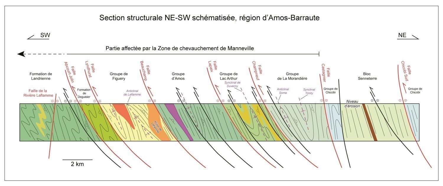
This area is affected by a series of ESE-WNW oriented synclinal and anticlinal folds, all overturned southward. Together, these folds represent the northern part of the Manneville Thrust Zone (Daigneault et al., 2002; Pilote et al., 2017, 2018), which continues northward to sedimentary rocks of the Chicobi Group. This thrust zone overlies the La Corne Batholith on the south side and extends west and east over several tens of kilometres (Pilote et al., 2009, 2017, 2018). It is bordered and cut by several E-W to ESE-WNW oriented longitudinal faults that dip moderately to steeply northward (Abcourt, Lyndhurst, Beauchamp, Lapaix and Champneuf faults). These faults, some of which could be associated with the development of the “Destor-Porcupine Fault Zone” (Daigneault et al., 2002; Legault et al., 2005; Pilote et al., 2009, 2017, 2018), converge towards the east and are ultimately cut by or imbricate with the Castagnier Fault. Some of these faults, or particular segments thereof, may have been reactivated during regional deformation and are associated with orogenic-type gold mineralization.
Methodology
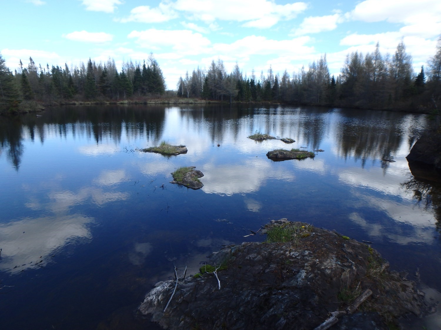
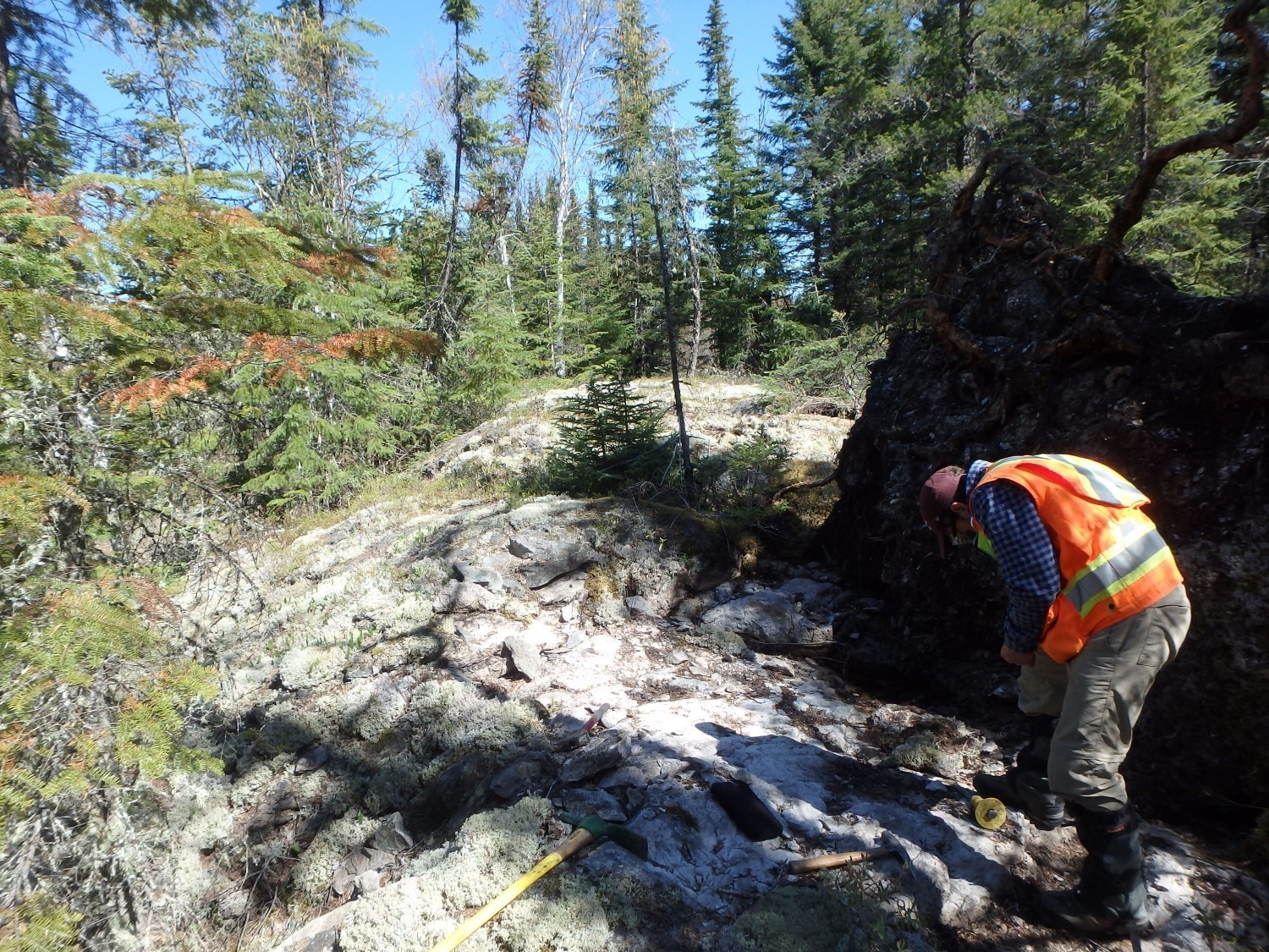
The Amos-Barraute area was mapped using the established method for surveys in forest areas served by a network of secondary roads. Geological mapping was conducted by a team of two geologists, and two students between the beginning of June and mid August 2019. This area has a low density of outcrops, with a very uneven distribution and considerable quaternary cover. The compilation of most of the available drill cores and aeromagnetic surveys has greatly contributed to the geological map.
The mapping and synthesis of the Normandin project has produced and updated information presented in the table to the right.
| Element | Number |
|---|---|
| Described outcrop (“geofiche”) | 198 outcrops |
| Total lithogeochemical analysis | 167 samples |
| Lithogeochemical analysis of metals of economic interest | 15 samples |
| Geochronological analysis | 4 samples |
| Covered thin section | 175 |
| Polished thin section | 5 |
| Sodium cobaltinitrite stain | 4 |
| Stratigraphic unit | 4 |
| Mineralization record | 21 |
Previous Work
The table below lists the work that has been done in the study area since 1910. It also includes references cited in the report.
| Author(s) | Type of Work | Contribution |
|---|---|---|
| Wilson and Prud’homme,1910 | Geological mapping | Reconnaissance mapping along the GSC’s planned transcontinental railway route |
| James and Mawdsley, 1929; Tremblay, 1946, 1947, 1950a, 1950b | Geological mapping | Detailed geology of the La Corne and Fiedmont areas by the GSC |
| Brown, 1957, 1958; Leuner, 1959; Sharpe, 1961; Doig, 1963; Jones, 1964; Weber and Latulippe, 1964; Beullac, 1983; Lacoste, 1984; Labbé, 1995 |
Geological mapping | Detailed geology of the Amos and Barraute areas by the Ministère |
| Pilote, 2015 | Geological mapping | Geology of the La Corne area (sheet CG-32C05A-2015-01) |
| MER, 1984 | Geological compilation | Geoscience compilation map of NTS sheet 32C05 (CG 032C/05) |
| Imreh, 1984 | Geological compilation | Synthesis of the La Motte-Vassan trough and its southern foreland |
| Imreh, 1991 | Geological compilation | Preliminary geological maps at scale 1:15 840 of the eastern part of southern Abitibi (NW quarter of sheet 32C05) |
| Latulippe and Ingham, 1955 | Description of mineralized zones | Lithium mineralization in the La Corne area |
| Dawson, 1966 | Geological mapping and description of mineralized zones | Studies of the various intrusive phases composing the Preissac-La Corne Batholith |
| Imreh, 1979 | Geological Association of Canada, Quebec City Congress 1979, Field Trip Guidebook | Lithostratigraphy and ultramafic rocks of the Val-d’Or-Amos area |
| Bell, 1931 | Description of gold mineralized zones | Venus Gold Mine, Barraute Township |
| Boily et al., 1989 | Description of mineralized zones | High-tech metallogeny in Abitibi-Témiscamingue |
| Labbé, 1999 | Geological surveys and metallogenic studies | Compilation of articles |
| Daigneault, 1996 | Description of Abitibi fault and shear zones | Deformation corridors in the Abitibi Subprovince |
| Keating, 1979 | Geophysical surveys | Compilation of INPUT-type electromagnetic anomalies |
| Geological Survey of Canada, Virginia Gold Mines, Noranda Exploration, 2009 | Geophysical surveys | MEGATEM colour geophysical maps (sheet 32C05) |
Lithostratigraphy
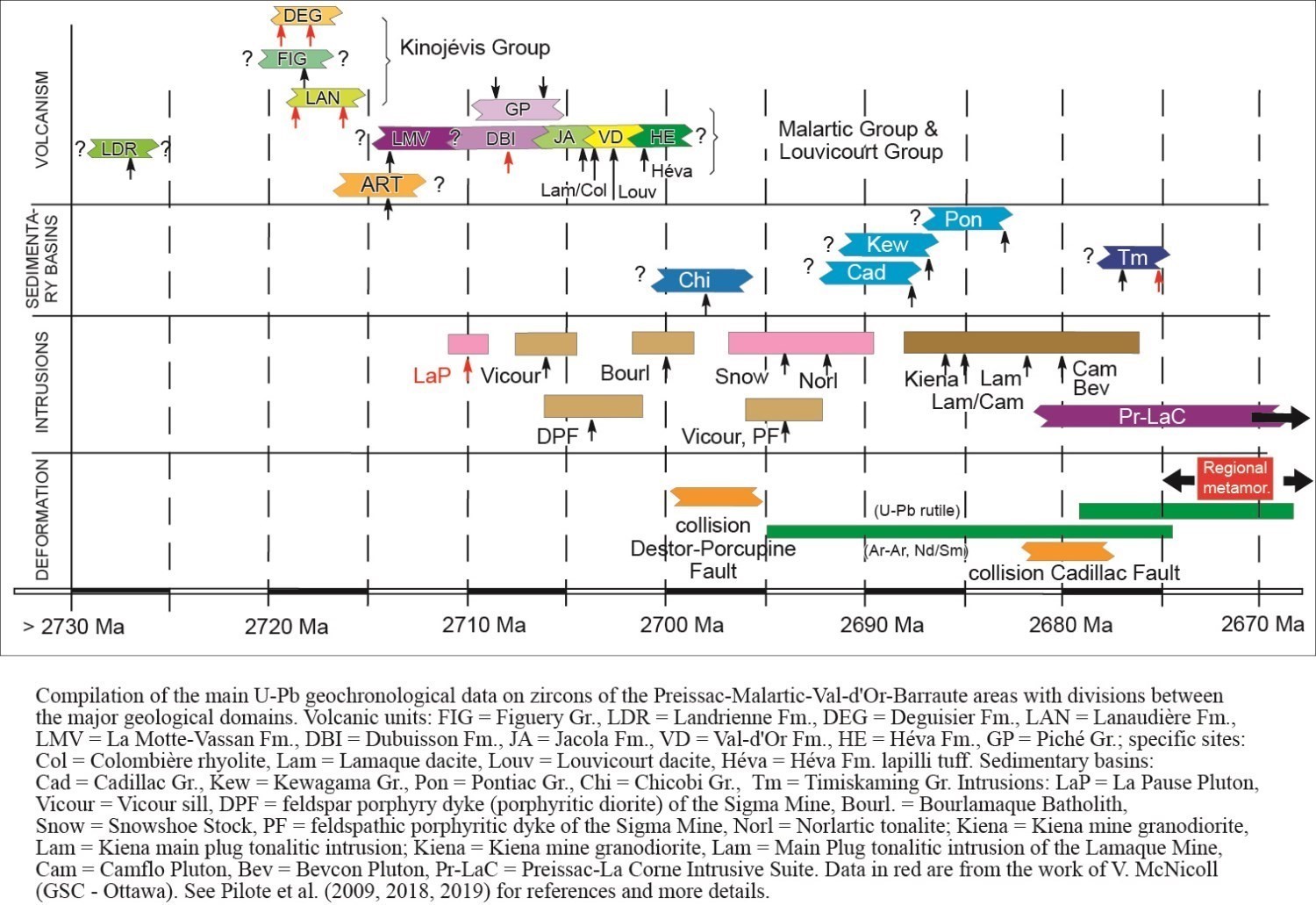
The Amos-Barraute area is located in the southern part of the Abitibi Subprovince of the Superior Province (Dimroth et al., 1982; Card and Ciesielski, 1986; Calvert and Ludden, 1999; Percival et al., 2012; Thurston et al., 2008). The geology of this area consists of an Archean volcano-sedimentary pile including mafic, intermediate and felsic volcanic and volcaniclastic rocks (2727 ±2 Ma to 2716 ±2 Ma; Pilote et al., 2009). A compilation of the main U-Pb dating on zircons is presented in the opposite figure.
In the Amos-Barraute area (sheet 32C12-SE ), one finds from south to north : 1) the Landrienne Formation (nAla); 2) the Deguisier Formation (nAdg); 3) the Figuery Group (nAfg); 4) the Amos Group (nAam); 5) the Lac Arthur Group (nAur); 6) the La Morandière Group (nAmr); and 7) Neoarchean volcanic rocks (since no group is assigned to any of these, we suggest the“Senneterre Block” as a temporary informal name). Numerous pretectonic to post-tectonic intrusions and dykes, ranging in composition from dioritic-tonalitic to monzonitic and monzogranitic, cut the volcanic sequence (e.g. the Laflamme Pluton).
Volcano-Sedimentary Units

The geological and stratigraphic settings of theAmos-Barraute area are well defined on the adjacent chronostratigraphic column thanks to the work of Weber and Latulippe (1964), Imreh (1979, 1984, 1991), Labbé (1995 and 1999), Otis and Béland (1986) and Pilote et al. (2018, 2019). Stratigraphic units in this area are described below from the oldest to the youngest. The relative chronology of the emplacement of these units is illustrated in this stratigraphic diagram, which takes into account crosscutting relationships observed in the field, as well as the geochronological data. This diagram represents a highly idealized section of the geology of the study area, indicating the age and/or contemporaneity relationships between units as well as their relative positions, taking into account the numerous faults and folding.
The Landrienne Formation (nAla) consists of basalt, gabbro sills, volcaniclastics and felsic volcanic rocks. The significant apparent thickness of this formation can be explained by the successive repetition of units caused by a series of overturned folds, including at least two synclines (Barraute and Figuery synclines, well visible in the NW quarter of sheet 32C05), and anticlines (NE and NW quarters of sheet 32C05). This formation is not assigned to any group. It is bordered by the longitudinal Abcourt (northern flank) and Aiguebelle (southern flank) faults. The Landrienne Formation includes a rhyolitic unit (2727 +/-2 Ma; Labbé, 1999) that is significantly older than adjacent volcanic rocks, located both to the north (Deguisier Formation) and south (Lanaudière Formation), and belonging to the Kinojevis Group (age range: 2716-2720 Ma; Pilote et al., 2009). This arrangement can likely be explained by the presence of a vast anticlinorium, the Manneville Thrust Zone, the central part of which is occupied by the Landrienne Formation and which is truncated by numerous faults, notably the Aiguebelle and Landome faults, as well as the Uniacke Deformation Corridor (Moorhead, 1988; 1989).
The Figuery Group (nAfg) consists of plagioclase porphyritic andesitic flows, intermediate to felsic volcaniclastics and felsic volcanic rocks. The Figuery Group is bordered by the Amos Group (Imreh, 1979; Labbé, 1999) and the Beauchamp Fault (Labbé, 1995; sheet 32C12) to the north, and by the Lyndhurst Fault and the Deguisier Formation to the south. The average age of Figuery Group volcanic rocks should be comparable to or slightly older than that attributed to the Taschereau Batholith (2718.3 +2.3/-2.2 Ma; Frarey and Krogh, 1986), a tonalitic to granodioritic intrusion interpreted as synvolcanic by Doucet (2001).
The Kinojévis Group (nAki) was divided into two formations by Goutier (1997), namely the Deguisier (nAdg) Formation at the base and the Lanaudière (nAln) Formation at the top. The Lanaudière Formation does not outcrop in sheet 32C12-SE; however, it is present in the sheet located immediately to the south (sheet 32C05-NE). The Deguisier Formation (nAdg) consists of tholeiitic basalt, thin chert layers between flows, tholeiitic rhyolite (2719.4 ±1 Ma and 2718.1 ±1.3 Ma; McNicoll, cited in Pilote et al., 2009) and intermediate to felsic volcaniclastic rocks. The Deguisier Formation is in fault contact with the Figuery Group to the north and the Landrienne Formation to the south. The Lanaudière Formation (nAln) consists of mafic to felsic volcanic rocks. The close spatial association observed between extrusive ultramafic rocks and rhyolitic complexes of this formation, dated at 2718.7 ±0.7 Ma and 2716.2 ±0.8 Ma (McNicoll, cited in Pilote et al., 2009) suggests several similarities with the Kidd-Munro assemblage (Bleeker, 1999; Berger, 2002; Ayer et al., 2002). On the other hand, the Lanaudière Formation is bounded to the south by the La Corne Batholith and to the north by the Aiguebelle Fault. This fault, which dips slightly northward (Mueller et al., 1996; Daigneault et al., 2002), may be one of the subsidiary faults of the Destor-Porcupine Fault Zone recognized further west (Goutier, 1997; Legault et al., 2005). Goutier (1997) and Pilote et al. (2009) have proposed that the Deguisier and Lanaudière formations were originally joint and subsequently separated by faults.
The Amos Group (nAam) cuts the study area from east to west (central part of sheet 32C12-SE). This group consists mainly of a monotonous suite of basalt commonly pillowed, locally interstratified with differentiated mafic-ultramafic sills, which include peridotite and gabbro (see Weeks, 1935; Tremblay, 1950; Webber and Latulippe, 1964; Imreh, 1979, 1984; Vogel and Keating, 1979; Ciesielski, 1980; Hébert, 1981, 1982; Otis and Béland, 1986; Labbé, 1994, 1995, 1999, and our work). All these sills represent multiple magma intrusions. The stratigraphic polarity of these rocks is regularly northward. The thickness of this group is ~3 km and proves to be very regular, except in an easterly direction where the Castagnier Fault gradually truncates the volcanic units. This group continues westward (sheet 32D09-32D10) and eastward (sheet 32C011-32C06). Metamorphism reaches the greenschist facies. The contact between the Amos and Figuery groups, on the south side, is interpreted as a fault. The northern contact, between the Amos and Lac Arthur groups, is occupied by the Lapaix Fault. There are no geochronological data for volcanic rocks of this group.
The Lac Arthur Group (nAur) consists of intermediate to felsic volcanic rocks and intrusions of gabbroic, dioritic, tonalitic and granodioritic compositions (see Cooke et al., 1933; Weeks, 1935; Tremblay, 1950; Webber and Latulippe, 1964; Imreh, 1979, 1984; Vogel and Keating, 1979; Ciesielski, 1980; Hébert, 1981, 1982; Otis and Béland, 1986; Labbé, 1994, 1995, 1999; Doucet and Dion, 1998a, 1998b; Doucet, 2001, and our work). Regional metamorphism reaches the greenschist facies. This group mainly occupies the central parts of sheets 32C12-SE and 32D09. It is found in smaller parts of sheets 32C06, 32D11, 32D15 and 32D16. Labbé (1999) revealed an age of 2714 +/-2 Ma for a rhyolitic tuff belonging to this group. This age corresponds to that assigned to the La Motte-Vassan Formation (2714 +/-2 Ma; Pilote et al., 1998, 1999, 2014; Pilote, 2000), located at the base of the Malartic Group. Felsic units of similar age (2713 +/-2 Ma; Corfu et al., 1989; Ayer et al., 2002) are recognized in Ontario, south of Abitibi Lake and in the Timmins area, and occupy the top of the Kidd Munro assemblage at these locations (Thurston et al., 2008).
The La Morandière Group (nAmr) consists of basaltic flows of tholeiitic affinity, felsic to intermediate volcaniclastic rocks, terrigenous and chemical sedimentary rocks, interstratified with subconformable, differentiated intrusive rocks of ultramafic-mafic to dioritic composition (see Cooke et al., 1933; Weeks, 1935; Tremblay, 1956; Webber and Latulippe, 1964; Imreh, 1979, 1984; Vogel and Keating, 1979; Ciesielski, 1980; Hébert, 1981, 1982; Otis and Béland, 1986; Labbé, 1994, 1995, 1999, and our work). The La Morandière Group is generally oriented WNW-ESE. Regional metamorphism reaches the greenschist facies. Volcanic units of the La Morandière Group are interpreted to be bordered and overlain along their northern and southern contacts by andesite of the Lac Arthur Group (Labbé, 1995, 1999). Although the contacts between La Morandière basalts and Lac Arthur Group andesites are not outcropping, Labbé (1995, 1999) interprets them as likely normal, due to the similarity between the attitudes of rocks of these two groups. The southern contact of the La Morandière Group is cut by the Champneuf Fault, while the NE part is gradually truncated by the Castagnier Fault. There are currently no geochronological data for volcanic rocks belonging to this group.
Pre-Kinematic to Late-Kinematic Intrusive Rocks
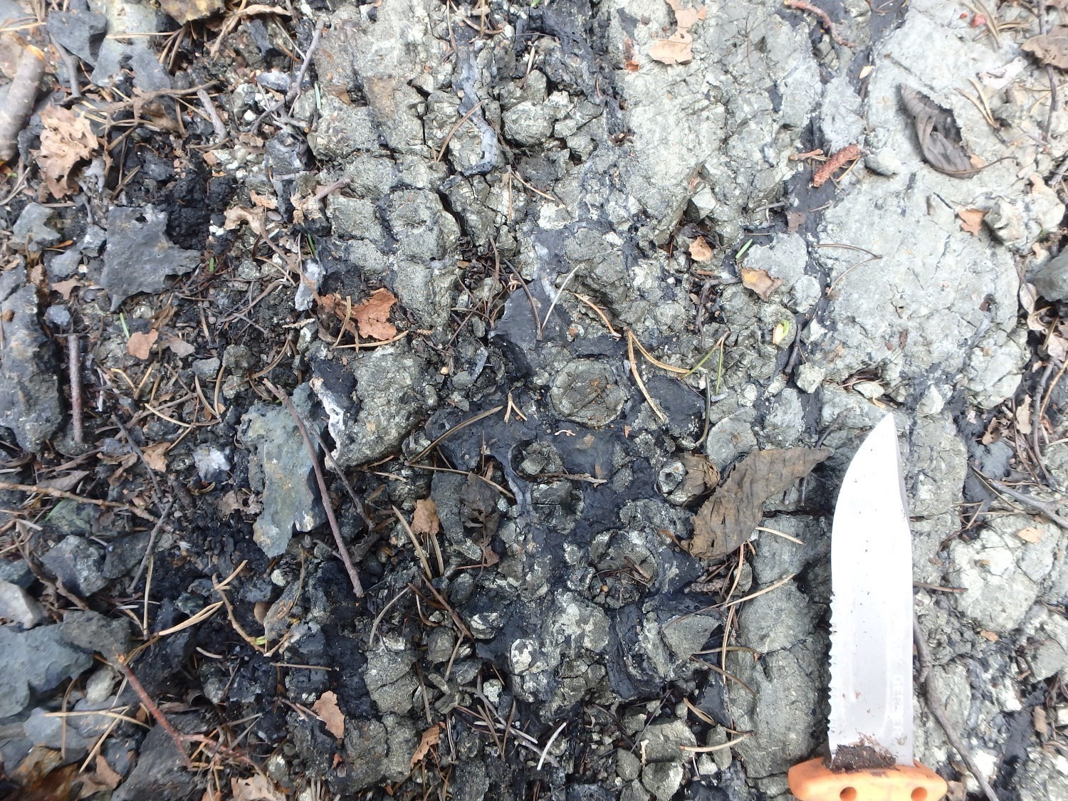
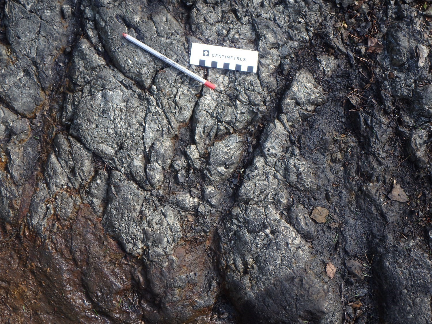
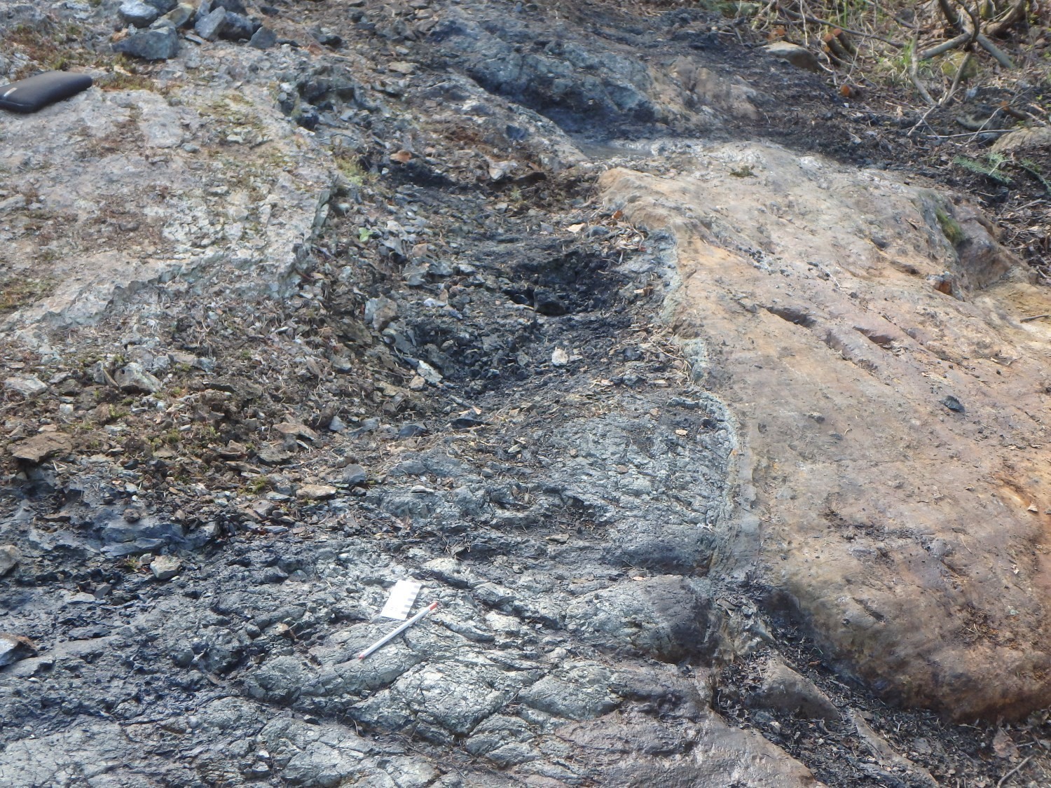
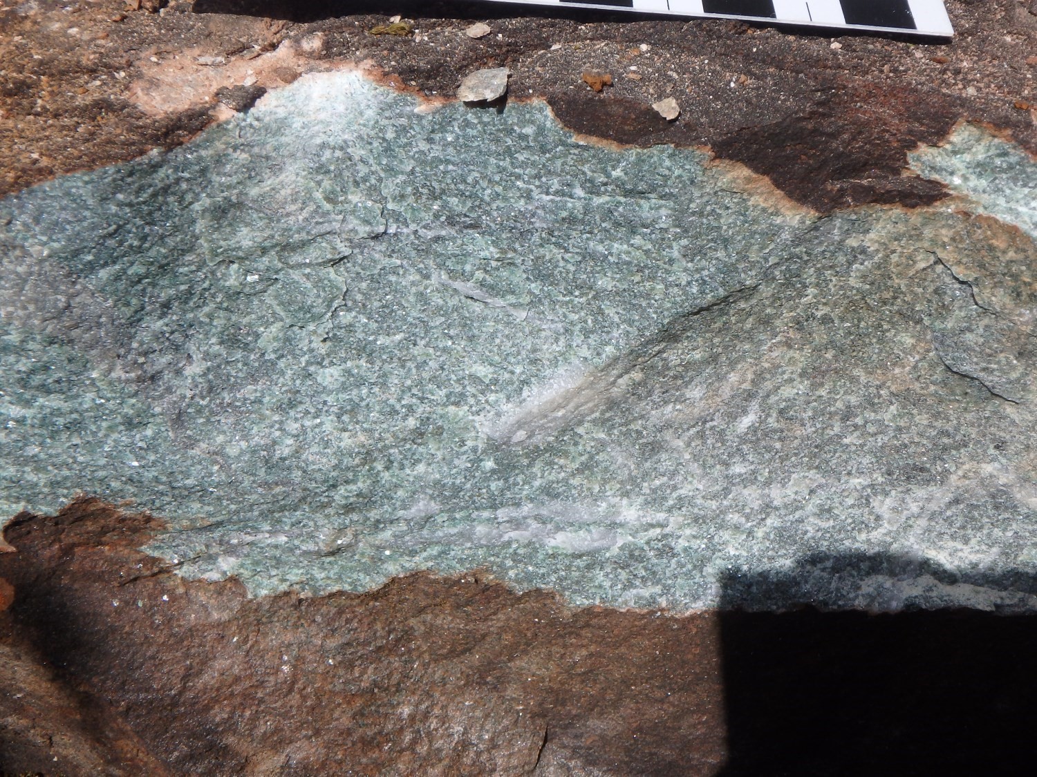
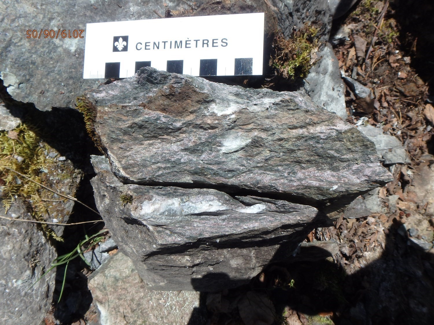
The Laflamme Pluton consists of varying proportions of monzonite, quartz monzonite and monzodiorite, commonly plagioclase and K-feldspar (pinkish white, millimetric) porphyritic. The granodioritic phase is only observed in very rare places. These lithologies, whitish grey in altered surface and greenish in fresh exposure, are massive and in places intensely fractured. The fine to medium-grained matrix is composed of feldspar, chloritized hornblende and quartz. Our work indicates that this pluton has a monzonite composition and a calc-alkaline affinity. Although there is an absence of penetrative fabric in this intrusion, there is nevertheless a magmatic foliation indicated by the preferential E-W orientation of plagioclase rods. The pluton contains enclaves of volcanic and volcaniclastic rocks at its southern and NW edges (see Damascus mineralized zone). The potassic nature of this pluton gives it a possible syntectonic to late-tectonic relative age. No lithology of syenitic composition was observed, however, contrary to the first interpretations made by Weber and Latulippe (1964). This interpretation of a syntectonic to late-tectonic age gives it a certain gold potential (Legault and Lalonde, 2009; Legault and Goutier, 2014). This intrusion is anomalous in gold and molybdenum associated with quartz-chlorite-carbonate-magnetite veins (Barraute Vll-56 mineralized zone; see Bérubé, 1978; Tremblay, 2007; Pelletier, 2016). The contacts of this intrusion were traced from aeromagnetic surveys (Geological Survey of Canada et al., 2009). They could not be observed on outcrops, although some have been intersected by drilling in its half-south part. Our mapping did not reveal any significant metamorphic aureole around this pluton. The latter is secant to stratification and regional schistosity.
A voluminous intrusion of granodioritic-tonalitic composition, without apparent outcrops, is located in the Figuery Group, SW of the Laflamme Pluton (central part of sheet 32C12-SE). This composition comes from the work of Weber and Latulippe (1964) and drilling descriptions (Trenholme, 1951; Le Mouel, 1983). This intrusion contains the Matico mineralized zone. There is no estimated age for this intrusion.
Proterozoic Diabase Dykes
The area west of Barraute is cut by three dyke swarms, two of which are Paleoproterozoic, the Senneterre and Biscotasing dykes, and the third is Mesoproterozoic, the Abitibi Dykes.
Senneterre Dykes (pPsen): diabase
Biscotasing Dykes (pPbis): diabase
Abitibi Dykes (mPabi): olivine diabase
The Biscotasing and Senneterre dykes consist of subophitic gabbro seams oriented ENE-WSW to NE-SW. Diabase has a characteristic brown patina and a fresh green surface. It is composed of plagioclase, pyroxene, olivine, chlorite and epidote. Hematite is locally very abundant. As for the Abitibi Dykes, oriented NE-SW to NNE, they consist of non-metamorphosed and weakly altered olivine diabase. These three swarms cut all volcanic rocks in the area. The various positions and orientations of these dykes as well as their interpreted trajectories were first plotted on the geological map of the work of Fahrig et al. (1986), Krogh et al. (1987) and Ernst and Buchan (1993). These are based on the orientation of paleomagnetism as well as the age derived from U-Pb dating of the dykes. Subsequently, the trajectories of these dykes were extrapolated in the peripheral areas using aeromagnetic surveys (see aeromagnetic maps and Geological Survey of Canada et al., 2009).
A particularly distinct generation of diabase dykes with a N-S orientation was also observed in the southern and NE parts of the map. These are highly magnetic subophitic gabbro dykes, displaying no evidence of metamorphism. These diabase dykes were also traced from their strong magnetic signature. This N-S oriented network is not assigned to any specific family of dykes at the moment.
Lithogeochemistry
The lithogeochemistry of units of the Amos area is presented separately in tabular form.
Structural Geology

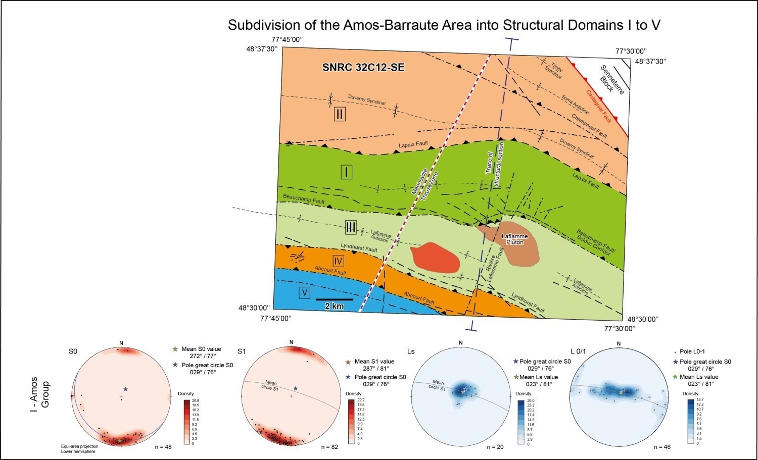
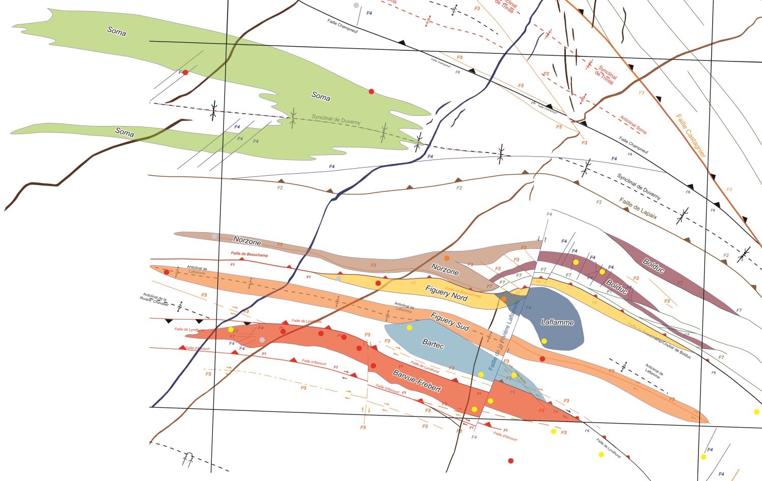
The following nomenclature has been applied to the description of the main structural elements of the Amos-Barraute area. The oldest schistosity has been designated S1. This schistosity contains observed stretch lineation. The S1 fabric therefore corresponds to regional schistosity.
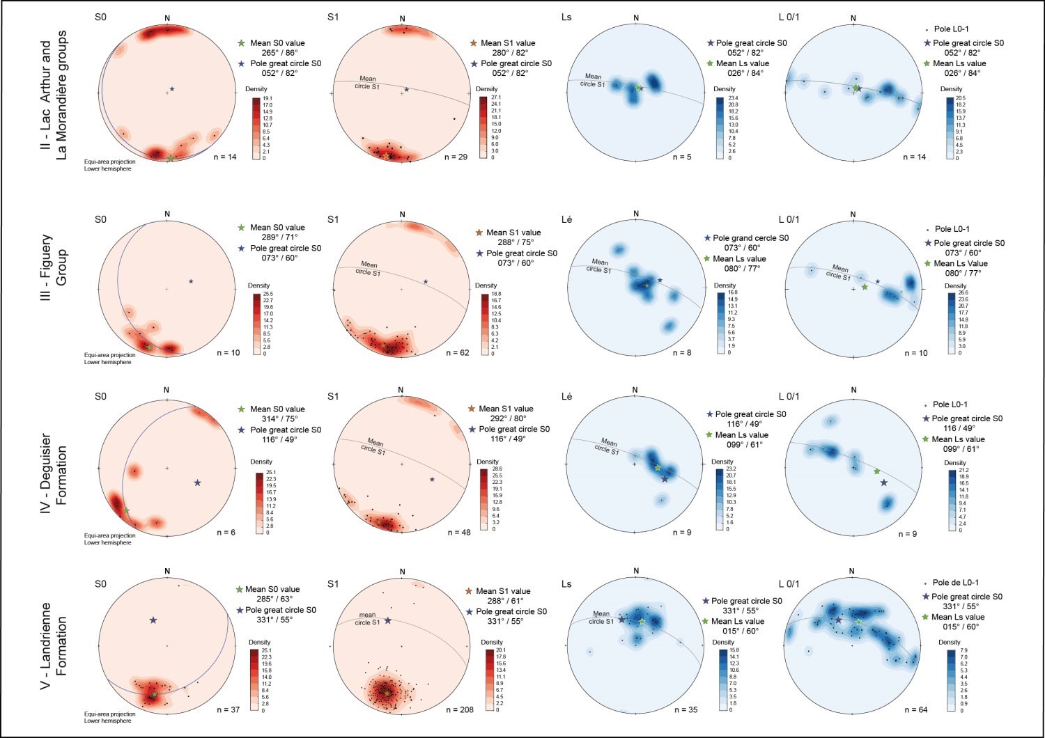
This schistosity commonly has a small angle or is subparallel to stratification S0, except near the hinges of large synclinal and anticlinal P1 folds (see the geological map, aeromagnetic gradient map, schematic N-S composite section and equi-area projections shown on stereonets opposite). The axial plane traces of these folds were defined by combining our field work, regional aeromagnetic surveys and adjacent geological maps. For example, the trace of the Duverny Syncline corresponds to the eastward extension of the same fold highlighted by the mapping campaigns of Weber and Latulippe (1964) and Labbé (1995). Planar elements S0 and S1 are oriented E-W to WNW and dip moderately (55°-75°) northward. The intensity of S1 is more pronounced in the vicinity of large regional faults. The stretch lineation Ls associated with this schistosity is commonly steeply dipping northward and towards the NNE, generally subparallel to the fabric S1‘s dip.
Thrust Zone and Axial Planes of Folds
The most remarkable structural element in the Amos-Barraute area (sheet 32C12-SE) is the abundance of synclinal and anticlinal folds, distributed in practically all groups and formations. These folds are oriented ESE-WNW and all overturned southward. Nowhere else in the Val-d’Or-Rouyn axis is such a high number of fold axes observed. For this reason, we suggest interpreting all of these folds as representing the northern part of the Manneville Thrust Zone (MTZ; Daigneault et al., 2002; Pilote et al., 2017, 2018), which likely continues northward to sedimentary rocks of the Chicobi Group. This thrust zone is underlain on the south side by the La Corne Batholith and extends west and east over several tens of kilometres (Pilote et al., 2009, 2017, 2018).
In the Amos-Barraute area, the distribution of structural elements and the traces of fold’s axial planes were defined by combining our field observations, regional aeromagnetic surveys and the various geological maps available from mining companies. For the Landrienne Formation (Domain V), data from the field campaigns of 2018 (Pilote et al., 2019) and 2019 were combined. The poles of S0 surfaces are distributed on a great circle whose theoretical fold axis (341°/55°) lies more or less close to the maximum concentration of stretch lineations Ls (015°/60°). The mean lineation has a moderate plunge (40-50°) towards the NNE. For the Deguisier Formation (domain IV), the poles of S0 surfaces are distributed on a great circle whose theoretical fold axis (116°/49°) is relatively close to the maximum concentration of stretch lineations Ls (099°/61). This is the domain having a mean stretch lineation with the best dominant eastward orientation. For the Figuery Group (domain III), the poles of S0 surfaces are distributed on a great circle whose theoretical fold axis (073°/60°) displays a good collinearity with the maximum concentration of stretch lineations Ls (080°/77°). For the Lac Arthur Group (domain II), the poles of S0 surfaces are distributed on a great circle whose theoretical fold axis (052°/82°) is relatively close to the maximum concentration of observed stretch lineations Ls (026°/84°). For the Amos Group (domaine I), the poles of S0 surfaces are distributed on a great circle whose theoretical fold axis (029°/76°) displays a very strong collinearity with the maximum concentration of stretch lineations Ls (023°/81°).
In more detail, for domains I to V, the observations of S0 and S1 planes on the same outcrop allowed calculating intersections defining fold axes (L0/L1). These axes are distributed on a great circle corresponding to the average schistosity of each domain. This distribution indicates that rocks in these domains are possibly slightly to severely affected by double-dipping folds. These are oriented towards the NW (domain V), east (domain IV) and NE (domains III, II and I). It is important to note that L0/L1 measurements are distributed over a mean great circle S1 with the mean lineation near the theoretical fold axis indicated by the combination of S0 measurements. Domains I to V thus present the same deformation style overall, but with Ls oriented slightly differently for each domain. The development of double-dipping folds is probably part of the continuity of regional deformation in the absence of a regional cleavage S2; this mechanism is probably part of the development of the MTZ (Daigneault et al., 2002; Pilote et al., 2018, 2019).
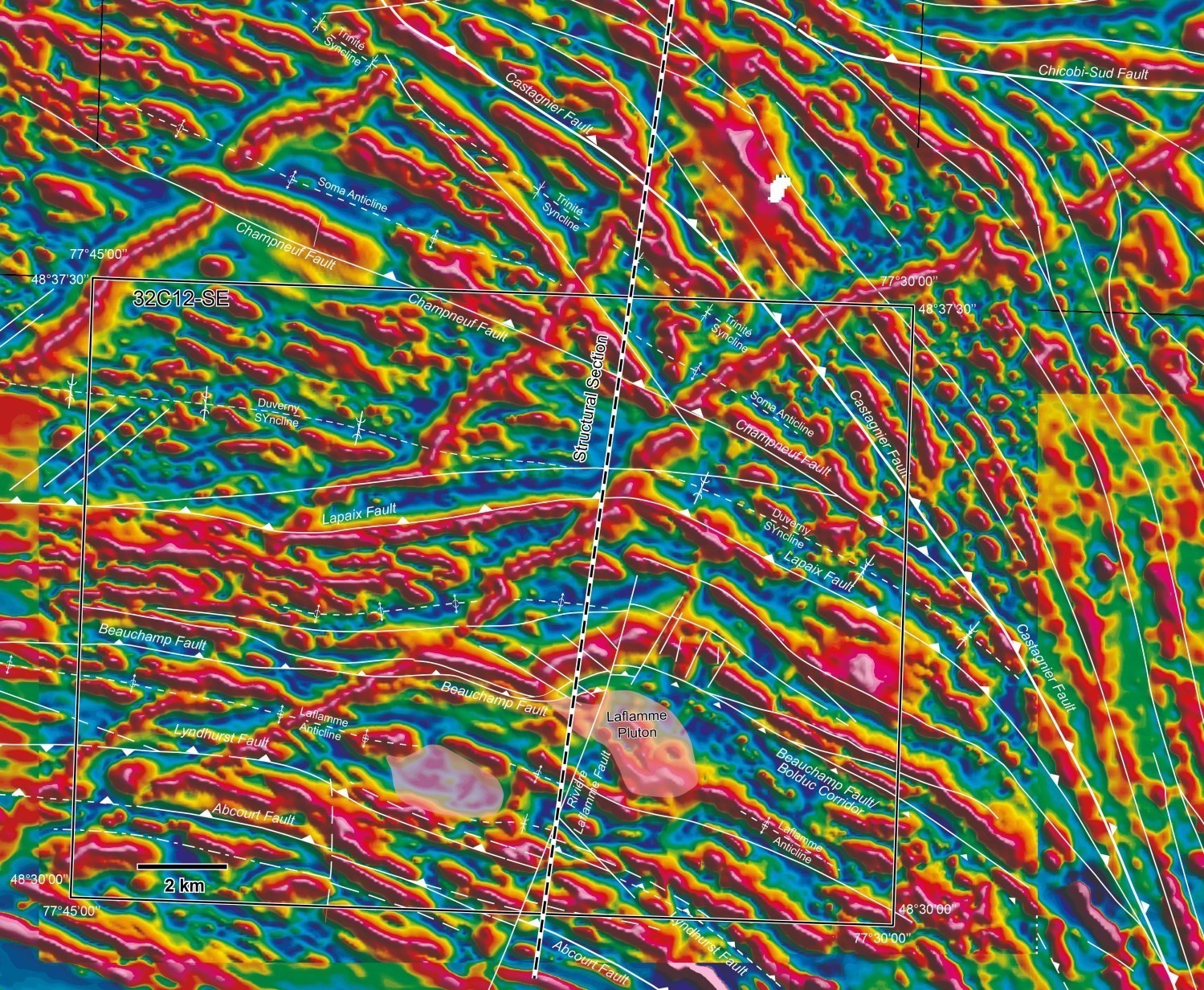
More generally, the Manneville Thrust Zone (Daigneault et al., 2002) affects in its half-south the entire Kinojevis Group, sedimentary rocks of the Fiedmont Formation, the Landrienne Formation (sheet 32C05-NE; Pilote et al., 2019), and in its half-north the Deguisier Formation as well as the Figuery, Amos and La Morandière groups. Finally, the MTZ is underlain by sedimentary rocks of the Chicobi Group to the north. The MTZ would thus have a possible N-S width of ~30 km (dashed line on the aeromagnetic map). This regional-scale thrust can be interpreted as a vast folded sequence, materialized in the Amos-Barraute area by a series of synclinal and anticlinal folds (Trinity, Soma, Duverny, Laflamme), all overturned southward and cut by faults. The most common indicators of polarity come from the arrangement of pillows observed in mafic to intermediate volcanic rocks.
Faults
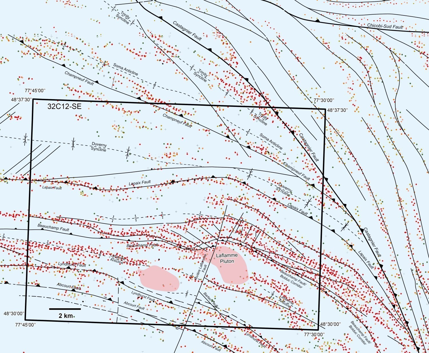
The MTZ is bordered and cut by several longitudinal faults oriented E-W to ESE-WNW and moderately to steeply dipping northward (Abcourt, Lyndhurst, Beauchamp, Lapaix and Champneuf faults). These faults, some of which could be associated with the development of the « Destor-Porcupine Fault Zone » (Daigneault et al., 2002; Legault et al., 2005; Pilote et al., 2009, 2017, 2018), converge eastward and are ultimately cut by or imbricate with the Castagnier Fault. Some of these faults (or particular segments of them) may have been reactivated during regional deformation. They are associated with orogenic gold mineralization. Maps of the aeromagnetic gradient and distribution of INPUT-type anomalies illustrate this convergence.
The borders and boundaries between formations and groups correspond mainly to shear zones and faults, or to areas with more intense planar deformation. Moreover, these faults truncate the extension of the axial planes of large folds. They are not very exposed and are poorly documented. In a westerly direction, these faults continue along a general E-W orientation over more than a hundred kilometres (up to sheets 32D10 and 32D15). In an easterly direction, the Castagnier Fault follows its trajectory or cuts all of the above-mentioned faults. Because of this crosscutting relationship, the Castagnier Fault does not seem to be included in this network and probably originates from another process, which could be linked to the amalgamation of the series of intrusions associated with the Montgay Batholith to volcanic piling.
The Destor-Porcupine Fault Zone (DPZ) represents a late structure compared to the development of the MTZ. The DPZ is marked in this area (sheet 32C12-SE) by the following regional faults, from south to north: Abcourt, Lyndhurst, Beauchamp, Lapaix and Champneuf faults. All of these E-W to NW-SE oriented structures play major roles as they: 1) affect the continuity of stratigraphic units; 2) form the edge of younger sedimentary units; 3) accommodate successive increments of regional deformation; and 4) materialize the potential for gold mineralization of a specific orogenic type, as demonstrated for example by a higher density of dykes and intrusions along or along the edge of their paths.
Smaller and later faults oriented NW, N-S and NE cut the large E-W faults described above. Apparent horizontal throws vary in amplitude from ~100 m to ~500 m maximum. Oriented NNE, the Rivière Laflamme Fault is a good example of these intersecting faults. Faults have been recognized or interpreted during mapping, drilling or through the numerous aeromagnetic and electromagnetic surveys conducted at different scales in this region.
Metamorphism
The degree of regional metamorphism observed in the Amos-Barraute area is very homogeneous and regular. It corresponds to the greenschist facies. The mineralogical assemblage typical of massive and pillowed mafic volcanic rocks consists of albite-chlorite-carbonate-quartz (Beullac, 1983; Imreh, 1984; Daigneault et al., 2002 ; Pilote et al., 2009, 2017, 2018). Ultramafic units (intrusions and sills) present a chlorite-actinolite-carbonate-serpentine-talc assemblage.
Economic Geology
The Barraute area comprises 11 prospective zones and four types of mineralization:
- Gold mineralization associated with orogenic-type veins hosted in shear zones;
- Massive sulphide mineralization of common metals associated with volcanic rocks;
- Cu-Au-Mo mineralization associated with alkaline porphyry intrusions;
- Gold mineralization associated with porphyry intrusions.
The table of mineralized zones below presents the compilation and analytical results for the 21 metallic and one non-metallic mineralized zones identified in the Amos-Barraute area.
Table of Mineralized Zones in the Amos-Barraute Area
| Name | Contents | Comments | ||
|---|---|---|---|---|
| Gold Mineralization Associated with Orogenic-Type Veins Hosted in Shear Zones | ||||
| Bar-Le-Duc | 11 660 ppb Au over 0.2 m (D); 3,5 ppm Ag (G) | Mineralization discovered by drilling | ||
| Barraute Vll-56 | 22 282 ppb Au (G); 8991 ppm Mo (G) | Numerous E-W oriented shear zones affected by intense chlorite-carbonate-hematite alteration | ||
| Bartec | Reserves were estimated at 113 400 t possible grading 7.9 g/t Au; 6.86 ppm Ag over 0.2 m (D) | Mineralized zone with very poor quality outcrops. | ||
| Jackson | 553 279.2 ppb Au over 0.8 m (D) | Mineralized zone with very poor quality outcrops. Felsic dykes (“granodioritic”, GM 46719) are cut by mineralized veins. | ||
| Laflamme Sud | 5970 ppb Au over 0.3 m (D); 23 800 ppm Cu over 0.2 m (D) | Mineralization discovered by drilling | ||
| Malbar/Gros Louis | 3770 ppb Au over 0.9 m (D) | Non-recovered outcrops; mineralized zone defined mainly by drilling. | ||
| Manville | 7200 ppb Au over 1.5 m (D); 1.4 ppm Ag over 1.5 m (D) | Mineralization discovered by drilling | ||
| Matico | 1317.2 ppb Au over 1.8 m (D); 39.08 ppm Ag over 1.8 m (D); 2000 ppm Mo over 0.6 m (D); 1500 ppm Cu over 0.5 m (D) | Mineralization discovered by drilling | ||
| Gold Mineralization Associated with Porphyry Intrusions | ||||
| Swanson | Reserves were estimated at 905 332 t in proven, probable and possible categories averaging 3.0 g/t Au. Proven reserves are 78 516 t at 2.1 g/t Au and probable reserves are 663 508 t at 3.1 g/t; 89 100 ppb Au over 1.5 m (D); 158.7 ppm Ag over 1.5 m (D); 4000 ppm Zn over 1.5 m (D); 7700 ppm Cr over 1.5 m (D). | Association between albitized tonalitic dykes, shear zones, quartz veins, carbonatization and gold mineralization | ||
| Massive Sulphide Mineralization of Common Metals Associated with Volcanic Rocks (VMS) | ||||
| Abcourt (Frebert) | Reserves were estimated at 2.14 Mt grading 175.88 g/t Ag and 4.01% Zn. These reserves may have been mined during the operation of the Abcourt mine; 98 500 ppm Zn over 1.5 m (D); 718.5 ppm Ag over 0.4 m (D); 2060 ppb Au over 0.9 m (D); 7300 ppm Pb over 1.5 m (D); 4000 ppm Cu over 1.5 m (D) | This mineralization is part of the Barvue belt, host to the Barvue Mine (Abcourt). | ||
| Abcourt (Pershcourt) | Reserves were estimated at 2.72 Mt proven grading 2.50% Zn and 48 g/t Ag. These reserves may have been mined during the operation of the Abcourt mine; 109 800 ppm Zn over 1.5 m (D); 577.96 ppm Ag over 0.9 m (D); 5900 ppm Pb over 0.6 m (D); 342.8 ppb Au over 0.9 m (D) | This mineralization is part of the Barvue belt, host to the Barvue Mine (Abcourt). | ||
| Bar-Manitou | 60 000 ppm Zn over 0.9 m (D); 465 ppm Ag over 1.2 m (D); 22 000 ppm Pb over 1.2 m (D) | This mineralization is part of the Barvue belt, host to the Barvue Mine (Abcourt). | ||
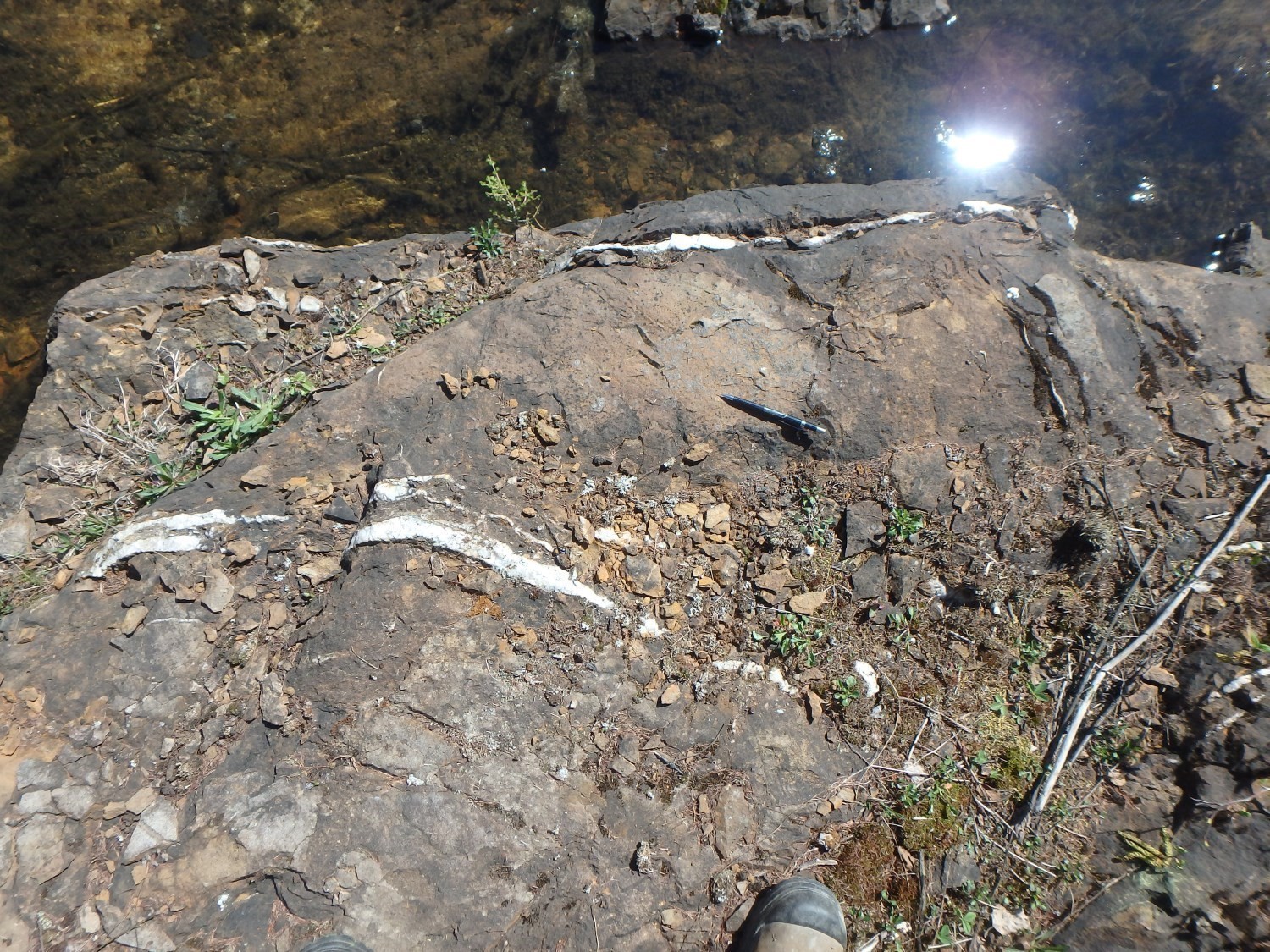
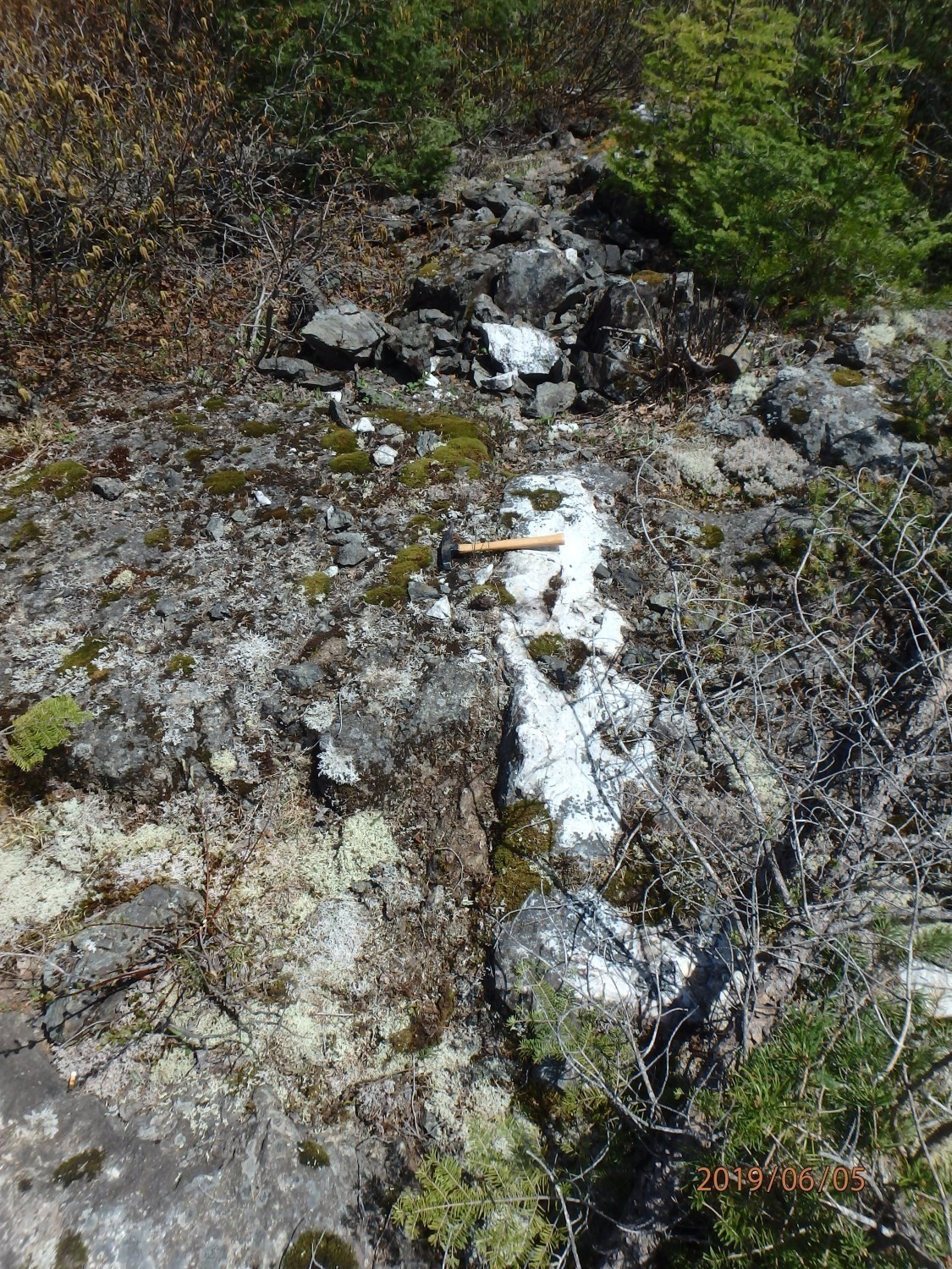
| Barraute Zinc | 7870 ppm Zn over 1.5 m (D); 837 ppm Pb over 1.5 m (D) | Exceptional quality exposure of radial-fibrous and framboidal pyrite clusters on outcrop 19-JM-507. Depending on the distribution and density of electromagnetic anomalies (INPUT) superimposed on it, this showing could have E-W lateral extensions of several hundred metres. | ||
| Damascus | 13 200 ppm Cu over 0.4 m (D); 59.3 ppm Ag over 0.4 m (D); 17 500 ppm Pb over 0.5 m (D) | Mineralization discovered by drilling | ||
| Frebert Extension Ouest | 21 000 ppm Zn over 0.8 m (D); 44.56 ppm Ag over 1.5 m (D) | This mineralization is part of the Barvue belt, host to the Barvue Mine (Abcourt). | ||
| Mine Barvue (Abcourt) | According to NI 43-101 “Mineral Resources Report for the Abcourt-Barvue Property, Feb. 28th 2014”: total measured and indicated resources (total M+I) are estimated at 8 085 998 t at 55.38 g/t Ag and 3.06% Zn. DV-91-01, page 43: reserves were estimated at 720 402 t grading 3.77 % Zn and 258 g/t Ag (1990-07-01); 150 000 ppm Zn over 1.2 m (D); 258 ppm Ag over 2.9 m (D); 6000 ppm Pb over 1.5 m (D) | Pit in operation from 1952 to 1957, operated by underground mining from 1985 to 1990 (see Bonneville and Baril, 2019). The main host lithologies appear to be volcaniclastics of intermediate composition. They are severely deformed and display numerous parasitic folds without much lateral continuity. Lithologies hosting this mine continue over several hundred metres. | ||
| Nealon-1 | 53 000 ppm Zn over 1.5 m (D); 12 500 ppm Cu over 6.1 m (D); 65.15 ppm Ag over 6.1 m (D) | Mineralization discovered by geophysical surveys and drilling | ||
| Norzone-1 | 11 400 ppm Cu over 0.2 m (D); 2056,8 ppb Au over 0.4 m (D); 34.97 ppm Ag over 0.6 m (D); 3100 ppm Zn over 0.2 m (D) | Mineralization discovered by drilling | ||
| Soma 11-430 | 18 000 ppm Zn over 1.5 m (D); 1900 ppm Cu over 1.5 m (D) | Mineralization discovered by drilling | ||
| Silver-Lead-Zinc Seam | ||||
| Filion Nord | 51.08 ppm Ag over 1.5 m (D); 2500 ppm Zn over 1.5 m (D); 1000 ppm Pb over 1.5 m (D) | Mineralization discovered by drilling | ||
| Frebert-FS 20 | 9.6 ppm Ag over 1.5 m (D); 3500 ppm Zn over 1.5 m (D); 342.8 ppb Au over 1.5 m (D); 1500 ppm Pb over 1.5 m (D) | Mineralization discovered by drilling | ||
| Non-Metallic Mineralization | ||||
| Mine Canadian Bolduc | Mineralization consists of transverse asbestos fibres 0.20 cm to 1.37 cm long. | Mine in operation from 1974 to 1977 and operated by Canadian Johns Mannville Ltd. | ||
| Architectural, Crushed and Industrial Stone | ||||
| Paradis | ||||
(D): Diamond drilling; (G): Selected sample; (R): Groove – chip sample
Prospective zones for volcanogenic massive sulphide mineralization in four units: the Figuery, Amos and Lake Arthur groups and the Deguisier Formation
 The Figuery Group comprises two prospective zones: Figuery Nord and Figuery Sud. These two zones include pyrite-graphite tuff as well as dacitic and andesitic units. The continuity of these conductive units is well illustrated by electromagnetic surveys (Geological Survey of Canada et al., 2009). The Figuery Nord prospective zone contains VMS zinc mineralization (Damascus, Nealon-1) consisting of subconformable pyrite-sphalerite clusters oriented E-W to WNW-ESE, and silver-bearing galena seams (Frebert-FS-20 mineralized zone). Regional deformation varies from weak to moderate. The intensity of silicification and chloritization is moderate. The Figuery Sud prospective zone contains the Barraute Zinc mineralized zones, which consists of subconformable pyrite-sphalerite clusters oriented WNW-ESE.
The Amos Group contains the Norzone prospective zone, which consists of layered, graphitic, pyritic and cherty felsic to intermediate volcaniclastic rocks, as well as dacitic and andesitic units. The continuity of this zone is well illustrated by electromagnetic surveys (Geological Survey of Canada et al., 2009). This zone contains the Norzone-1 and East Sullivan (Barraute) sites (off map, sheet 32C01-SW) which consist of subconformable pyrite-sphalerite clusters oriented E-W to WNW-ESE. Regional deformation varies from low to moderate. Silicification and chloritization are significant.
The Lac Arthur Group comprises the Soma prospective zone. This zone is hosted in felsic volcanic rocks of dacitic composition located in the NW part of sheet 32C12-SE. These units host the Soma 11-430 and La Morandière-Extrémité Ouest sites (off map, sheet 32C12-SW), which host VMS zinc-silver mineralization. This mineralization consists of thin siliceous, chloritic and carbonatized layers containing disseminated sulphides (pyrite, pyrrhotite, sphalerite, chalcopyrite). These volcanic rocks commonly present massive and fragmentary endogenous facies. Regional deformation varies in intensity from low to moderate.
The Deguisier Formation contains the Barvue-Frebert prospective zone, which occurs in the southern part of sheet 32C12-SE and represents the continuity towards the NW of the Blind-Nod prospective zone located in sheet 32C06-NE (see BG Barraute-Est; Pilote et al., 2019). The Barvue-Frebert prospective zone hosts VMS Zn-Ag-Cu mineralization of the Barvue (Abcourt) deposit and the Bar-Manitou, Abcourt (Pershcourt), Abcourt (Frebert) and Frebert Extension Ouest. This deposit and these mineralized zones are hosted in volcaniclastic rocks of dacitic composition. Stratification has a moderate to steep dip northward. The intensity of regional deformation is significant due to the presence of the Abcourt and Lyndhurst faults. An important observation should be highlighted: lode gold-silver mineralization such as those encountered in the Jackson, Malbar/Gros Louis, Filion Nord and Bar-Le-Duc mineralized zones also occur in this prospective zone, further indicating potential for precious metal mineralization.
BOLDUC PROSPECTIVE ZONE: GOLD MINERALIZATION ASSOCIATED WITH PORPHYRY INTRUSIONS
 This gold prospective zone, named Bolduc, is represented by the Swanson and Manville mineralized zones. Significant gold values are associated with a point concentration of thin, intensely albitized, carbonatized (ankerite) and hematitized porphyritic tonalitic dykes hosted in WNW-oriented shear zones. These dykes, previously identified as syenite, consist mostly of severely albitized tonalite. They are embedded in ultramafic and mafic intrusions, subconformable to local stratification and intensely sheared, with associated fuchsite. Tonalite dykes are polyphase. Gold mineralization appears to be associated with a pyritization halo spreading around these dykes. It should be noted that numerous graphitic and pyritic volcaniclastic units of regional extent units border mafic-ultramafic intrusions on their southern flanks and represent areas of interest for nickel mineralization. A former asbestos mine (Canadian Bolduc Mine) is located in this prospective zone.
LAFLAMME PROSPECTIVE ZONE: GOLD MINERALIZATION ASSOCIATED WITH ALKALINE INTRUSIONS (CU-AU-MO)
 This prospective zone, named Laflamme, is limited to the Laflamme Pluton. This porphyraceous pluton of granodioritic composition represents a prospective zone for quartz vein-type Cu-Au-Mo mineralization hosted in fractures and shear zones. These veins are commonly oriented NW-SE and E-W with moderate to steep dips northward. Several of these veins show carbonatized and sheared walls. The Barraute-VII-56 site is located in this zone. Molybdenite is observed locally in some quartz veins. Available observations could also suggest telescoping between models of alkaline porphyry mineralization (Cu-Au-Mo) and Au-Ag lode gold mineralization hosted in shear zones.
BARTEC AND CARPENTIER PROSPECTIVE ZONES: GOLD VEINS OF OROGENIC TYPE WITH QUARTZ-CARBONATE GANGUE
 This prospective zone, named Bartec, contains gold mineralization associated with quartz veins hosted in shear zones. This zone corresponds mainly to a pluton of granodioritic to tonalitic composition surrounded by a narrow strip of felsic to intermediate volcanic rocks of the Figuery Group. These shear zones are commonly oriented NW-SE and E-W have moderate to steep dips northward. The Bartec, Laflamme Sud and Matico mineralized zones are located in this zone. A concentration of gold mineralization located to the SE in adjacent sheet 32C06-NW, and constituting the Carpentier prospective zone (see among others the 1694, Jolin : Zone Ouest and Savane sites), represents a prospective zone comparable to that of Bartec.
DISCUSSION AND CONCLUSIONS
The revision of cartographic and geophysical data, combined with drilling observations, allowed clarifying the architecture of the Amos-Barraute area and to highlight the following points about geological units:
• The Figuery, Amos, Lac Arthur and La Morandière groups and the Deguisier Formation have relatively close ages of emplacement (2720-2714 Ma), suggesting a certain contemporaneity and cohesion within these various sequences. The Landrienne Formation remains anomalous and is distinguished by its estimated age of 2727 Ma (sheet 32C05-NW), in the area of the Projet 70-Landome mineralized zone. Additional sites will be required to confirm and validate this estimated age for the Landrienne Formation;
• The kilometric extent of the Manneville Thrust Zone, a wide strip consisting of volcano-sedimentary rocks affected by multiple synclines and anticlines (overturned southward);
• The more or less severe obliteration and truncation of synclines and anticlines developed in the Manneville Thrust Zone by fractures associated with the Porcupine-Destor Fault Zone. The Porcupine-Destor Fault Zone is represented by regional structures such as the Abcourt, Lyndhurst and Beauchamp faults (Bolduc corridor). Some segments of these structures contain particular alkaline intrusive suites and may show associations with orogenic gold occurrences.
| Authors |
Pierre Pilote, Eng., M.Sc.A. pierre.pilote@mern.gouv.qc.ca; Jonathan Marleau, GIT. |
| Geochemistry | Fabien Solgadi, P. Geo., Ph.D. |
| Geophysics | Rachid Intissar, P. Geo., M.Sc. |
| Potential assessment | Hanafi Hammouche, P. Geo., M.Sc. |
| Logistics | Marie Dussault |
| Geomatics |
Kathleen O’Brien Ghyslain Roy |
| Template and content compliance | François Leclerc, P. Geo., Ph.D. |
| Coaching/mentoring and critical review |
James Moorhead, P. Geo., M.Sc. |
| Organization | General Direction of Géologie Québec, Ministère de l’Énergie et des Ressources naturelles, Government of Québec |
Acknowledgements:
This Geological Bulletin was made possible through the cooperation of many people who actively took part in the various stages of the project. We would like to warmly thank students Aube Gourdeau and Miguel St-Denis for their enthusiasm and the quality of their work. James Moorhead (MERN) and Pierre Lacoste (MERN) are also thanked for the exhaustive reading of this document and the many comments made at the various stages of the project. The staff of Mines Abcourt (Mr. Eugène Gauthier) and Corp. Aurifère Monarques (Mr. Ron Lieber) were of great assistance in the evaluation and compilation work of the Bar-Manitou, Mine Barvue, Abcourt (Pershcourt), Abcourt (Frebert), Frebert Extension Ouest and Swanson deposits.
References
Publications of the Government of Québec
BELL, L.V. 1931. La mine d’or Vénus, canton de Barraute, comté d’Abitibi, Partie B. Services des mines de Québec; RASM 1930-B3, pages 45-58.
BERUBE, M., 1978. JOURNAL DE SONDAGES AU DIAMANT, TERRAIN BROMINCO INC. BROMINCO INC, assessment work submitted to the Government of Québec. GM 34345, 8 pages, 1 map.
BEULLAC, R. 1983. Région de Barraute-Fiedmont. Ministère des Richesses naturelles, Québec; DP-84-02, 1 plan.
BOILY, M., PILOTE, P., RAILLON, H., 1989. LA METALLOGENIE DES METAUX DE HAUTE TECHNOLOGIE EN ABITIBI-TEMISCAMINGUE. MRN; MB 89-29, 118 pages, 1 map.
BROWN, W.G. 1957. The Northeast part of Fiedmont Township, Abitibi-East County. Ministère des Richesses naturelles, Québec; DP 011, 50 pages and 1 plan.
BROWN, W G. 1958. Rapport préliminaire sur le quart nord-est du canton de Fiedmont, district électoral d’Abitibi-Est. Ministère des Richesses naturelles, Québec; RP 364, 30 pages and 1 plan.
CIESIELSKI, A. 1980. Géologie du canton de Villemontel (Comté d’Abitibi-Ouest). Ministère des Ressources naturelles, Québec; DPV 706, 78 pages and 1 plan.
COMMISSION GÉOLOGIQUE DU CANADA, NORANDA EXPLORATION, MINES D’OR VIRGINIA INC. 2009a. Cartes géophysiques couleurs Megatem – 32C05. Ministère des Ressources naturelles et de la Faune, Québec; DP 2008-06, 5 pages and 4 plans.
DAIGNEAULT, R. 1996. Couloirs de déformation de la Sous-province de l’Abitibi, Ministère des Richesses naturelles, Québec; MB 96-33, 140 pages.
DOIG, R. 1963. Géologie du quart sud-est du canton de Landrienne et quart sud-ouest du canton de Barraute, comté d’Abitibi-Est. Ministère des Richesses naturelles, Québec; RP 510, 14 pages and 2 plans.
DOUCET, P. 2000. Géologie de la région de Taschereau, de Sainte-Gertrude-Manneville et de Villemontel. Ministère des Ressources naturelles, Québec; RG 2000-08, 34 pages and 3 cartes.
DOUCET, P., DION, D.-J. 1998a. Géologie de la région de Languedoc (SNRC 32D/15-200-0102). Ministère des Ressources naturelles, Québec; RG 98-12, 29 pages.
DOUCET, P., DION, D.-J. 1998b. Géologie de la région d’Authier-Nord (SNRC 32D/15-200-0102). Ministère des Ressources naturelles, Québec; RG 98-11, 28 pages.
GOUTIER, J. 1997. Géologie de la région de Destor (SNRC 32D/07-200-0201). Ministère de l’Énergie et des Ressources naturelles, Québec; RG 96-13, 37 pages.
HEBERT, R., 1981. LITHOSTRATIGRAPHIE DU CANTON DE VILLEMONTEL (COMTE D’ABITIBI-EST). MRN; DP 785, 18 pages, 2 maps.
HEBERT, R., 1982. Géologie du complexe de filons-couches d’Amos, Québec. MRN; DP 786, 28 pages, 1 map.
IMREH, L. 1984. Sillon de La Motte-Vassan et son avant-pays méridional : synthèse volcanologique, lithostratigraphique et gîtologique. Ministère de l’Énergie et des Ressources, Québec; MM 82-04, 72 pages.
IMREH, L. 1991. Cartes préliminaires au 1:15 840 de l’Abitibi-Est méridional, coupure 32C05 W. Ministère des Richesses naturelles, Québec; MB 90-39, 18 pages and 2 plans.
JONES, R.E. 1964. Quart nord-ouest du canton de Fiedmont, comté d’Abitibi Est. Ministère des Richesses naturelles, Québec; RG 108, 34 pages.
KEATING, P., 1979. COMPILATION D’ANOMALIES ELECTROMAGNETIQUES DE TYPE INPUT. MRN; DP 728, 4 maps.
LABBÉ, J.-Y. 1994. Synthèse géologique de la région d’Amos, Abitibi. Ministère des Ressources naturelles, Québec; MB 94-09, 13 pages.
LABBÉ, J.-Y. 1995. Géologie de la région d’Amos – Comté d’Abitibi-Est. Ministère des Ressources naturelles, Québec; MB 95-24, 27 pages.
LABBÉ, J.-Y. 1999. Évolution stratigraphique et structurale dans la région d’Amos-Barraute. Ministère de l’Énergie et des Ressources naturelles, Québec; ET 98-04, pages 5-18.
LACOSTE, P., 1984. GEOLOGIE DE LA REGION DU LAC FIEDMONT. MRN; DP-84-15, 1 map.
LATULIPPE, M., INGHAM, W. N., 1955. LITHIUM DEPOSITS OF THE LACORNE AREA, QUEBEC. MRN; S 023, 8 pages.
LEGAULT, M., GOUTIER, J., BEAUDOIN, G., AUCOIN, M. 2005. Synthèse métallogénique de la faille de Porcupine-Destor, Sous-province de l’Abitibi. Ministère de l’Énergie et des Ressources naturelles, Québec; ET 2005-01, 37 pages.
LEGAULT, M., LALONDE, A. E., 2009. DISCRIMINATION DES SYENITES ASSOCIEES AUX GISEMENTS AURIFERES DE LA SOUS-PROVINCE DE L’ABITIBI, QUEBEC, CANADA. UNIVERSITE D’OTTAWA – DEPT SCIENCES DE LA TERRE, MRNF; RP 2009-04, 10 pages.
LE MOUEL, H. 1983. Journal de sondages, projet Abcourt. Mines d’argent Abcourt Inc. Assessment report submitted to the Government of Québec. GM 40536, 7 pages and 2 plans.
LEUNER, W. R., 1959. PRELIMINARY REPORT ON THE WEST HALF OF LAMOTTE TOWNSHIP, ABITIBI-EAST ELECTORAL DISTRICT. MRN; RP 405(A), 11 pages, 2 maps.
MER. 1984. Carte de compilation géoscientifique – 032C/05. CG 032C/05, 16 plans.
MOORHEAD, J. 1988. Projet Carpentier-Tavernier, Phase 1. Ministère de l’Énergie et des Ressources naturelles, Québec; DV 88-03,
page 77.
OTIS, M., BÉLAND, G. 1986. Projet de cartographie – région d’Amos. Ministère de l’Énergie et des Ressources, Québec; MB 86-21, 138 pages and 14 plans.
PELLETIER, P.-A., 2016. Evaluation report on the Barraute property. CLAIMS LAUZIER, assessment work submitted to the Government of Québec. GM 70123, 24 pages.
PILOTE, P. 2000. Géologie de la région de Val-d’Or, Sous-province de l’Abitibi: volcanologie physique et évolution métallogénique. Ministère de l’Énergie et des Ressources du Québec, MB 2000-09.
PILOTE, P. 2015. Géologie – La Corne. Ministère de l’Énergie et des Ressources naturelles, Québec; CG-32C05A-2015-01, 2 plans.
PILOTE, P., MUELLER, W., SCOTT, C., LAVOIE, S., CHAMPAGNE, C., MOORHEAD, J. 1998. Volcanologie de la Formation Val-d’Or et du Groupe de Malartic, Sous-province de l’Abitibi: contraintes géochimiques et géochronologiques. Ministère des Ressources naturelles du Québec; DV 98-05, page 48.
PILOTE, P., SCOTT, C., MUELLER, W., LAVOIE, S., RIOPEL, P. 1999. Géologie des Formations Val-d’Or, Héva et Jacola – nouvelles interprétations du Groupe de Malartic. Ministère des Ressources naturelles du Québec; DV 99-03, page 19.
PILOTE, P., McNICOLL, V., DAIGNEAULT, R., MOORHEAD, J. 2009. Géologie et nouvelles corrélations dans la partie ouest du Groupe de Malartic et dans le Groupe de Kinojévis, Québec. Ministère des Ressources naturelles et de la Faune, Québec; MB 2009-09, pages 55-60.
PILOTE, P., DAIGNEAULT, R., DAVID, J., McNICOLL, V. 2014. Architecture des groupes de Malartic, de Piché et de Cadillac et de la Faille de Cadillac, Abitibi. Révision géologique, nouvelles datations et interprétations. Ministère de l’Énergie et des Ressources Naturelles, Québec, DV 2015-03, p. 37.
PILOTE, P., LACOSTE, P., BEDEAUX, P. 2017. Géologie – lac Fiedmont. Ministère de l’Énergie et des Ressources naturelles, Québec; CG-2016-15, 2 plans.
PILOTE, P., DAIGNEAULT, R., MOORHEAD, J. 2018. Géologie de la région de Barraute Ouest, Sous-province de l’Abitibi, région de l’Abitibi-Témiscamingue, Québec, Canada. Ministère de l’Énergie et des Ressources naturelles, Québec; BG 2018-05, 1 plan.
PILOTE, P., MARLEAU, J., DAVID, J. 2019. Géologie de la région de Barraute, Sous-province de l’Abitibi, région de l’Abitibi-Témiscamingue, Québec, Canada. MERN. BG 2019-06, 2 plans.
TREMBLAY, R. J., 2007. Rapport, travaux d’exploration 2004-2006, propriété Barraute. CLAIMS BEAUDOIN, assessment work submitted to the Government of Québec. GM 63153, 71 pages, 4 maps.
TRENHOLME, L S. 1951. DIAMOND DRILL LOG. MATICO MINES LTD. Assessment report submitted to the Government of Québec. GM 01285-B, 29 pages and 1 plan.
VOGEL, D.E., KEATING, P. 1979. Canton de Trecesson. Ministère des Ressources naturelles, Québec; RG 194, 50 pages and 2 plans.
WEBER, W.W., LATULIPPE, M. 1964. Région d’Amos- Barraute, comté d’Abitibi-Est. Ministère des Richesses naturelles, Québec; RG-109.
Other Publications
AYER, J., AMELIN, Y., CORFU, F., KAMO, S., KETCHUM, J., KWOK, K., TROWELL, N., 2002. Evolution of the southern Abitibi greenstone belt based on U-Pb geochronology: autochthonous volcanic construction followed by plutonism, regional deformation and sedimentation. Precambrian Research; volume 115, pages 63-95. doi.org/10.1016/S0301-9268(02)00006-2
BERGER, B.R., 2002. Geological synthesis of the Highway 101 area, east of Matheson, Ontario. Ontario Geological Survey; Open File Report 6091, 124 pages.
BLEEKER, W., 1999. Structure, stratigraphy, and primary setting of the Kidd Creek volcanogenic massive sulphide deposit; a semiquantitative reconstruction. Economic Geology Monographs: volume 10, pages 71-121.
BONNEVILLE, P., BARIL, F., 2019. Update to the technical feasibility report on the Abcourt-Barvue deposit. 43-101 Report, submitted to the Toronto Stock Exchange. Source
CALVERT, A.J., LUDDEN, J.N., 1999. Archean continental assembly in the southeastern Superior Province of Canada. Tectonics; volume 18, pages 412-429. doi.org/10.1029/1999TC900006
CARD, K.D., CIESIELSKI, A., 1986. Subdivisions of the Superior Province of the Canadian Shield. Geoscience Canada; volume 13, pages 5-13. Source
COOKE, H.C., JAMES, W.F., MAWDSLEY, J.B., 1933. Geology and ore deposits of Rouyn-Harricanaw region, Quebec. Geological Survey, Department of Mines, Canada; Memoir 166, 314 pages. doi.org/10.4095/119956
CORFU, F., KROGH, T.E., KWOK, Y.Y., JENSEN, L.S., 1989. U-Pb zircon geochronology in the southwestern Abitibi greenstone belt, Superior Province. Canadian Journal of Earth Sciences; volume 26, pages 1747-1763. doi.org/10.1139/e89-148
DAIGNEAULT, R., MUELLER W.U., CHOWN, E.H., 2002. Oblique Archean subduction: accretion and exhumation of an oceanic arc during dextral transpression, Southern Volcanic Zone, Abitibi Subprovince, Canada. Precambrian Research; volume 115, pages 261-290. doi.org/10.1016/S0301-9268(02)00012-8
DIMROTH, E., IMREH, L., ROCHELEAU, M., GOULET, N., 1982. Evolution of the south-central segment of the Archean Abitibi belt, Québec. Part I: stratigraphy and paleogeographic model. Canadian Journal of Earth Sciences; volume 19, pages 1729-1758. doi.org/10.1139/e83-125.
ERNST, R.E., BUCHAN, K.L., 1993. Paleomagnetism of the Abitibi dyke swarm, southern Superior Province, and implications for the Logan Loop. Canadian Journal of Earth Sciences, volume 30, pages 1886-1897. doi.org/10.1139/e93-167
FAHRIG, W.F., GAUCHER, E.H., LAROCHELLE, A., 1986. Diabase dykes swarms of the Canadian Shield – Essaims de dykes diabasiques du Bouclier canadien. Commission géologique du Canada, carte 1627A. doi.org/10.4095/133917
FRAREY, M.J., KROGH, T.M., 1986. U-Pb Zircon Ages of Late Internal Plutons of the Abitibi and eastern Wawa Subprovinces, Ontario and Quebec. Geological Survey of Canada; Current Research Part A, Paper 86-1A, pages 43-48. doi.org/10.4095/120348
IMREH, L., 1979. Lithostratigraphie et roches ultramafiques du secteur de Val-d’Or – Amos. Association géologique du Canada – Association minéralogique du Canada, congrès de Québec, 1979; livret-guide de l’excursion A-4, pages 1-40.
JAMES, W.F., MAWDSLEY, J.B., 1929. Fiedmont Sheet, Abitibi County, Quebec. Geological Survey of Canada, Map 206A: 1 sheet. doi.org/10.4095/107481
KROGH, T.E., CORFU, F., DAVIS, D.W., DUNNING, G.R., HEAMAN, L.M., KAMO, S.L., MACHADO, N., GREENOUGH, J.D., NAKAMURA, E., 1987. Precise U-Pb isotopic ages of diabase dykes and mafic to ultramafic rocks using trace amounts of baddeleyite and zircon. Dans: Mafic dyke swarms. Éditeurs: H.C. Halls et W.F. Fahrig. Geological Association of Canada, Special Paper 34, pages 147-152.
MOORHEAD, J., 1989. The relative timing of structural and metamorphic events in the Senneterre region, Eastern Abitibi belt, Quebec. In GAC-MAC Congress, Vancouver 1990, Vol. 15, Program and abstracts, page A90.
MUELLER, W.U., DAIGNEAULT, R., MORTENSEN, J.K., CHOWN, E.H., 1996. Archean terrane docking: upper crust collision tectonics, Abitibi greenstone belt, Quebec, Canada. Tectonophysics; volume 265, pages 127-150. doi.org/10.1016/S0040-1951(96)00149-7
PERCIVAL, J.A., SKULSKI, T., SANBORN-BARRIE, M., STOTT, G.M., LECLAIR, A.D., CORKERY, M.T., BOILY, M., 2012. Geology and tectonic evolution of the Superior province, Canada. Chapter 6. Dans : Tectonic styles in Canada: The Lithoprobe perspective (Éditeurs : J.A. Percival, F.A. Cook, R.M. Clowes). Geological Association of Canada; Special Paper 49, pages 321-378.
THURSTON, P.C., AYER, J.A., GOUTIER, J., HAMILTON, M.A., 2008. Depositional gaps in Abitibi greenstone belt stratigraphy: a key to exploration for syngenetic mineralization. Economic Geology; volume 103, pages 1097-1134. doi.org/10.2113/gsecongeo.103.6.1097
TREMBLAY, L.P., 1946. Lacorne map-area, Abitibi County, Quebec. Geological Survey of Canada; Paper 46-13, 6 pages, 1 sheet. doi.org/10.4095/101406
TREMBLAY, L.P., 1947. Lacorne map-area, Abitibi County, Quebec. Geological Survey of Canada; Paper 47-8, 7 pages, 1 sheet. doi.org/10.4095/101402
TREMBLAY, L.P., 1950a. Fiedmont, Québec. Geological Survey of Canada; Series Map 999a, 1 sheet. doi.org/10.4095/107478
TREMBLAY, L.P., 1950b. Fiedmont map area, Abitibi county, Quebec. Geological Survey of Canada; Memoir 253, 113 pages. doi.org/10.4095/101590.
TREMBLAY, L.P. 1956. Région de Fiedmont, comté d’Abitibi, Québec. Commission géologique du Canada; Mémoire 253 (version française), 141 pages et 1 plan. doi.org/10.4095/119963
WEEKS, L.J., 1935. Amos sheet, Abitibi County, Quebec. Geological Survey of Canada, Ottawa; map 327A.doi.org/10.4095/107158
WILSON, W.J., PRUD’HOMME, U.E., 1910. Vicinity of the National Transcontinental Railway, Abitibi District, Quebec. Geological Survey of Canada; Map 12A, 1 sheet. doi.org/10.4095/107162