

Last modified:
Translation of original French
None
| Author: | Duquette and Mathieu, 1966 |
| Age: | Neoarchean |
| Reference section: | Reference outcrop in sheet 32J01-200-0102 (UTM NAD83, zone 18: 561847E, 5541786N) located in a section described by Bélanger (1979) along the Waconichi Lake access road |
| Type area: | NTS sheets 32G09, 32G10, 32G15 and 32G16 |
| Geological province: | Superior Province |
| Geological subdivision: |
Abitibi Subprovince |
| Lithology: | Felsic volcanic rocks |
| Type: | Lithostratigraphic |
| Rank: | Formation |
| Status: | Formal |
| Use: | Active |
- Roy Group
-
- Bordeleau Formation
- Ruisseau Dalime Formation
- Scorpion Formation
- Phooey Member
- Blondeau Formation
- Bruneau Formation
- Waconichi Formation
- Allard Member
- Scott Member
- Deux Orignaux Member
- Winchester Member
- Lemoine Member
- Portage Member
- Lacs Member
- Îles Member
- Coyote Member
- Chevrier Member
- Queylus Member
- Andy Member
- Obatogamau Formation
- Pichamobi Member
- Wachigabau Member
- David Member
Background
The Waconichi Formation established by Duquette and Mathieu (1966) originally consisted of volcaniclastic rocks occupying the Waconichi Lake basin, in the NE quarter of McKenzie Township (sheet 32G16-200-0201). The thickness of this unit was initially estimated at 12 500 m, but was reduced to 2400 m following Caty’s mapping of Richardson Township (1975), which limited the Waconichi Formation to volcaniclastic rocks between Gwillim and Waconichi lakes (northern portion of sheet 32G16). Subsequently, several small and spatially discontinuous felsic rock units were incorporated into the Waconichi Formation (Allard, 1976; Henry and Allard, 1979; Allard et al., 1985; Daigneault and Allard, 1990; Chown et al., 1991). Thus, the Lemoine (rhyolitic rocks), Queylus (volcaniclastic rock) and Portage (Algoma-type iron formation and volcaniclastic rock) facies were included in the Waconichi Formation based on petrographic and geochemical criteria (Daigneault and Allard, 1990; Chown et al., 1991).
Detailed mapping of the Haüy area subsequently led to the addition of the Andy (Daigneault and Allard, 1990), Lacs, Coyote, Chevrier and Îles (Legault, 2003) members. Characterization of felsic volcanic rocks following detailed mapping, drilling, geochronology and geochemistry has resulted in significant refinement of the stratigraphy of this unit (Lafrance et al., 2006; Roy et al., 2007; McNicoll et al., 2008; Leclerc et al., 2011; David et al., 2012). The Lemoine, Queylus and Portage facies are now considered formal members of the Waconichi Formation, which also includes the Scott and Allard members (Leclerc et al., 2011). The Lemoine Member contains an informal division that distinguishes the lower and upper portions of the unit (Roy et al., 2007; Boulerice et al., 2013; Mercier-Langevin et al., 2014). The Deux Orignaux Member is introduced to designate Waconichi Formation rocks exposed in the northern part of Deux Orignaux Lake (northern portion of sheet 32G14), while the Winchester Member includes rocks located south of Winchester and Trois Îles lakes (sheet 32G10-200-0102).
Description
The Waconichi Formation is mainly exposed on the north and south flanks of the Chibougamau Anticline (sheets 32G09, 32G10, 32G15, 32G16), near the Chibougamau Pluton and Lac Doré Intrusive Suite.
The Waconichi Formation consists of the following twelve members:
- Allard Member: basaltic to dacitic volcaniclastic rock, andesite to dacite, laminated metasedimentary rock, chert and exhalite;
- Scott Member: rhyolite, dacite, felsic volcaniclastic rock, andesitic basalt, andesite, graphitic metasedimentary rock, chert and exhalite;
- Deux Orignaux Member: mafic to intermediate volcaniclastic rock, arkose and mudrock;
- Winchester Member: Intermediate to felsic volcaniclastic rock and dacite;
- Lemoine Member: dacite, rhyolite, felsic volcaniclastic rock, andesite, basalt and diorite;
- Portage Member: Algoma-type iron formation and intermediate to felsic volcaniclastic rock;
- Lacs Member: basaltic to andesitic volcaniclastic rock;
- Îles Member: Intermediate to felsic volcaniclastic rock;
- Coyote Member: dacite, porphyritic rhyodacite and felsic block and lapilli tuff;
- Chevrier Member: porphyritic dacite, block and lapilli tuff and felsic intrusion;
- Queylus Member: mafic to felsic volcaniclastic rock and dacite;
- Andy Member: mafic to felsic volcaniclastic rock, basalt and andesitic basalt.
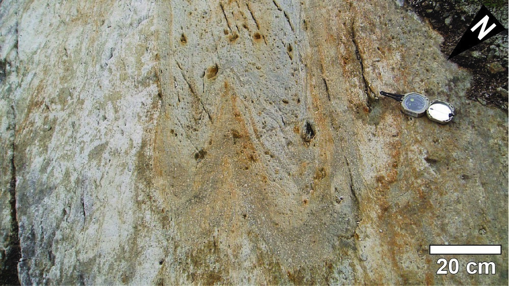
The reference outcrop exposes a green-beige monomictic block tuff cemented by a light to dark grey matrix. South of Waconichi Lake, this facies forms lenses in a sequence of quartzofeldspathic and feldspathic metatuffs (Bélanger, 1979). These volcaniclastic rocks are part of the Waconichi Formation as originally established by Duquette and Mathieu (1966).
Thickness and Distribution
The actual thicknesses of the various members of the Waconichi Formation generally do not exceed 1000 m (Daigneault and Allard, 1990; Leclerc et al., 2017). Most of the units associated with the Waconichi Formation appear on the north and south flanks of the Chibougamau Anticline, near or directly in contact with rocks of the Lac Doré Intrusive Suite and Chibougamau Pluton. This is the case for rocks assigned to the Queylus, Andy, Portage, Lemoine, Scott and Allard members (sheets 32G09, 32G10, 32G15, and 32G16). Rocks of the Chevrier, Coyote, Îles, Lacs and Winchester members are distributed between the Verneuil Pluton and Eau-Jaune Complex (sheet 32G10). The Deux Orignaux Member outcrops west of Chapais (northern portion of sheet 32G14).
Dating
The emplacement of the Waconichi Formation has been dated at several locations. The following ages of volcanism were obtained:
- Allard Member lapilli and block tuff at Allard Park: 2726.6 ±0.7 Ma (Leclerc et al., 2011);
- Allard Member lapilli and block tuff from the edge of Road 167: 2726.7 ±0.7 Ma (Leclerc et al., 2011);
- Allard Member lapilli and block tuff from Faribault logging area: 2727.4 ±0.9 Ma (Leclerc et al., 2011);
- Deux Orignaux Member lapilli tuff: 2726.7 ±1.1 Ma (David et al., in preparation);
- Scott Member porphyritic rhyolite (nAsct5): 2728.2 ±0.8 Ma (Leclerc et al., 2011);
- Lemoine Member's lower unit porphyritic rhyolite (nAlem1f): 2728.0 +1.5/-1.4 Ma (Mortensen, 1993);
- Lemoine Member's upper unit porphyritic rhyolite (nAlem2a): 2729.7 +1.9/-1.6 Ma (Mortensen, 1993);
- Queylus Member lapilli and block tuff: 2728.7 ±1.0 Ma (Leclerc et al., 2011);
- Andy Member lapilli and block tuff: 2729.0 ±1.1 Ma (David et al., 2012);
- Two plagioclase-quartz porphyritic felsic dykes of the Chevrier Member: 2729.9 +1.6/-1.3 Ma (crystallization age; Legault, 2003).
| Isotopic System | Mineral | Crystallization Age (Ma) | (+) | (-) | Reference(s) |
| U-Pb | Zircon | 2726.6 | 0.7 | 0.7 | Leclerc et al., 2011 |
| U-Pb | Zircon | 2726.7 | 0.7 | 0.7 | Leclerc et al., 2011 |
| U-Pb | Zircon | 2727.4 | 0.9 | 0.9 | Leclerc et al., 2011 |
| U-Pb | Zircon | 2726.7 | 1.1 | 1.1 | David et al., in preparation |
| U-Pb | Zircon | 2728.2 | 0.8 | 0.8 | Leclerc et al., 2011 |
| U-Pb | Zircon | 2728.0 | 1.5 | 1.4 | Mortensen, 1993 |
| U-Pb | Zircon | 2729.7 | 1.9 | 1.6 | Mortensen, 1993 |
| U-Pb | Zircon | 2728.7 | 1.0 | 1.0 | Leclerc et al., 2011 |
| U-Pb | Zircon | 2729.0 | 1.1 | 1.1 | David et al., 2012 |
| U-Pb | Zircon | 2729.9 | 1.6 | 1.3 | Legault, 2003 |
Stratigraphic Relationship(s)
Rocks of the Waconichi Formation form the upper part of the Roy Group's first volcanic cycle (Allard et al., 1979; Daigneault and Allard, 1990; Leclerc et al., 2017). The different members of this formation correspond to discontinuous but contemporary felsic volcanic centres overlying a plain of basalts and andesitic basalts (Obatogamau Formation). Rocks of the Waconichi Formation are overlaid by basalts and andesitic basalts of the Bruneau Formation, which characterizes the base of the Roy Group's second volcanic cycle.
Paleontology
Does not apply.
References
| Author(s) | Title | Year of Publication | Hyperlink (EXAMINE or Other) |
|---|---|---|---|
| ALLARD, G.O. | Doré Lake Complex and its importance to Chibougamau geology and metallogeny. Ministère des Richesses naturelles, Québec; DP 368, 446 pages, 2 plans. | 1976 | DPV 368 |
| ALLARD, G.O. – CATY, J.-L. – GOBEIL, A. | The Archean supracrustal rocks of the Chibougamau area. In Evolution of Archean Supracrustal Sequences (Ayres, L.D., Thurston, P.D., Card, K.D. and Weber, W., editors). Geological Association of Canada; Special Paper 28, pages 55–63. | 1985 | - |
| BÉLANGER, J. | Étude de la zone de transition entre la Formation de Waconichi et la Formation de Gilman, Groupe de Roy, Chibougamau, Québec. Université du Québec à Chicoutimi; master's thesis, 83 pages. | 1979 | Source |
| BOULERICE, A.R. – ROSS, P.-S. – MERCIER-LANGEVIN, P. – LÉPINE, S. – LECLERC, F. | Volcanologie de la Formation de Waconichi, secteur Lemoine, Chibougamau (sous-province de l’Abitibi). Résumés des conférences et des photoprésentations, Québec Mines 2013. Ministère des Ressources naturelles, Québec; DV 2014-03, page 59. | 2013 | DV 2014-03 |
| CATY, J.-L. | Géologie de la demie-ouest du canton de Richardson (comté d'Abitibi-Est). Ministère des Richesses naturelles, Québec; DP-342, 14 pages, 2 plans. | 1975 | DP 342 |
| CHOWN, E.H. – DAIGNEAULT, R. – MUELLER, W. | Part 1: Geological setting of the eastern extremity of the Abitibi belt. In Lithotectonic framework and associated mineralization of the eastern extremity of the Abitibi Greenstone Belt, Quebec (Field Trip 3) (Guha, J., Chown, E.H. and Daigneault, R., editors). Geological Survey of Canada; Open File 2158, pages 1–32. | 1991 | Source |
| DAIGNEAULT, R. – ALLARD, G.O. | Le Complexe du lac Doré et son environnement géologique (région de Chibougamau, Sous-province de l'Abitibi). Ministère de l'Énergie, des Mines et des Ressources, Québec; MM 89-03, 275 pages. | 1990 | MM 89-03 |
| DAVID, J. – SIMARD, M. – BANDYAYERA, D. – GOUTIER, J. – HAMMOUCHE, H. – PILOTE, P. – LECLERC, F. – DION, C. | Datations U-Pb effectuées dans les provinces du Supérieur et de Churchill en 2010-2011. Ministère des Ressouces naturelles et de la Faune, Québec; RP 2012-01, 33 pages. | 2012 | RP 2012-01 |
| DUQUETTE, G. – MATHIEU, A. | Géologie du quart nord-est du canton de McKenzie, comté d'Abitibi-Est. Ministère des Richesses naturelles, Québec; RP-551, 28 pages, 1 plan. | 1966 | RP 551 |
| HENRY, R.L. – ALLARD, G.O. | Formation ferrifère du Lac Sauvage, cantons de McKenzie et de Roy, région de Chibougamau. Ministère des Richesses naturelles, Québec; DPV 593, 100 pages, 1 plan. | 1979 | DPV 593 |
| LAFRANCE, B. – BRISSON, T. – McNICHOLS, D. – LAMBERT, G. | Rapport sur le programme de forage 2005, Projet Lemoine. Ressources Cogitore, rapport statutaire soumis au ministère des Ressources naturelles et de la Faune, Québec; GM 62564, 334 pages, 13 plans. | 2006 | GM 62564 |
| LECLERC, F. – BÉDARD, J.H. – HARRIS, L.B. – McNICOLL, V. – GOULET, N. – ROY, P. – HOULE, P. | Tholeiitic to calc-alkaline cyclic volcanism in the Roy Group, Chibougamau area, Abitibi Greenstone Belt – Revised stratigraphy and implications for VHMS exploration. Canadian Journal of Earth Sciences; volume 48, pages 661–694. | 2011 | Source |
| LECLERC, F. – ROY, P. – HOULE, P. – PILOTE, P. – BÉDARD, J.H. – HARRIS, L.B. – McNICOLL, V.J. – VAN BREEMEN, O. – DAVID, J. – GOULET, N. | Géologie de la région de Chibougamau. Ministère de l’Énergie et des Ressources naturelles, Québec; RG 2015-03, 97 pages, 3 plans. | 2017 | RG 2015-03 |
| LEGAULT, M. | Environnement métallogénique du couloir de Fancamp avec emphase sur les gisements aurifères de Chevrier, région de Chibougamau, Québec. Université du Québec à Chicoutimi; doctoral thesis, 488 pages. | 2003 | Source |
| MERCIER-LANGEVIN, P. – LAFRANCE, B. – BÉCU, V. – DUBÉ, B. – KJARSGAARD, I. – GUHA, J. | The Lemoine Auriferous Volcanogenic Massive Sulfide Deposit, Chibougamau Camp, Abitibi Greenstone Belt, Quebec, Canada : Geology and Genesis. Economic Geology; volume 109, pages 231-269. | 2014 | Source |
| MORTENSEN, J.K. | U-Pb geochronology of the eastern Abitibi subprovince. Part 1: Chibougamau – Matagami – Joutel region. Canadian Journal of Earth Sciences; volume 30, pages 11-28. | 1993 | Source |
| ROY P. – FALLARA, F. – HOULE, P. – CHENG, L.Z. – RABEAU, O. – BLAIS, A. – LAFRANCE, B. – LECLERC, F. – PILOTE, P. – RIVERIN, G. – SCHMITT, L. |
Étude sur le flanc sud du Complexe du Lac Doré, Chibougamau : stratigraphie, veines Cu-Au et modèle 3D préliminaire. Québec Exploration 2007, Résumés des conférences et des photoprésentations. Ministère des Ressources naturelles et de la Faune, Québec; DV 2007-04, page 37. |
2007 | DV 2007-04 |