


Last modified: 19 October 2022
DISCLAIMER: This English version is translated from the original French. In case of any discrepancy, the French version shall prevail.
| Author(s): | Leclerc et al., 2008 |
| Age: | Neoarchean |
| Stratotype: | The stratotype corresponds to an outcrop located at the emergency exit of the former Bruneau Mine (NTS sheet 32G16, UTM NAD83, zone 18: 553459 m E, 5531755 m N). |
| Type area: | The Bruneau Formation is very well exposed in the Bruneau Mine area (sheet 32G16-200-0201). |
| Geological province: | Superior Province |
| Geological subdivision: | Abitibi Subprovince |
| Lithology: | Mafic volcanic rocks |
| Category: | Lithostratigraphic |
| Rank: | Formation |
| Status: | Formal |
| Use: | Active |
- Roy Group
-
- Bordeleau Formation
- Ruisseau Dalime Formation
- Scorpion Formation
- Phooey Member
- Blondeau Formation
- Bruneau Formation
- Waconichi Formation
- Allard Member
- Scott Member
- Deux Orignaux Member
- Winchester Member
- Lemoine Member
- Portage Member
- Lacs Member
- Îles Member
- Coyote Member
- Chevrier Member
- Queylus Member
- Andy Member
- Obatogamau Formation
- Pichamobi Member
- Wachigabau Member
- David Member
Background
The Bruneau Member was first defined as the upper part of the Gilman Formation (now abandoned) by Leclerc et al. (2008). Two U-Pb isotopic datings on zircon from volcaniclastic rocks of the Allard Member (2726.5 ±0.7 Ma and 2726.7 ±0.7 Ma; Leclerc et al., 2011), previously attributed to the Gilman Formation, provided comparable ages to felsic rocks underlying the Waconichi Formation (between 2726 Ma and 2730 Ma; Mortensen, 1993; Legault, 2003; Leclerc et al., 2011; David et al., 2012 et 2018), leading to a revision of the stratigraphy of the Roy Group and elevating the Bruneau Member to the rank of formation (Leclerc et al., 2011).
Description
Bruneau Formation 1 (nAbnu1): Basalt to Andesitic Basalt, Amphibolite

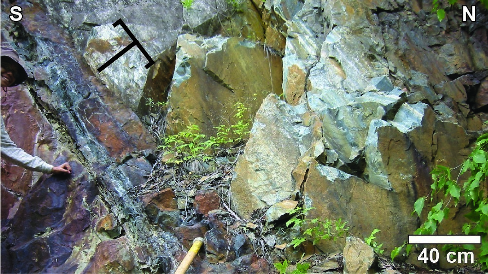
Mafic volcanic rocks make up more than 90% of the Bruneau Formation. The pillow facies is dominant in this unit, except in the upper portion. Massive, pillowed and brecciated flows forming unit nAbnu1 occur in succession over thicknesses ranging from a few metres to a few tens of metres. Pillows are decimetric to metric with dark green margins and triple junctions filled with hyaloclastic material. Primary pillow morphology is generally preserved and allows for measuring stratigraphic polarity. However, these structures are difficult to recognize in more heavily deformed zones. Mafic volcanic rocks of the Bruneau Formation have a distinctive light green to white patina, distinguishing them from mafic volcanic rocks of the Obatogamau Formation, which instead have a dark green patina. This lighter patina appears to indicate diffuse silica and epidote alteration (Trudeau, 1981).
In the la Trêve Lake area, some outcrops show sulphide enrichment, particularly in the interpillow material, which has a rusty color (outcrops 2021-YD-2016, 2021-MB-3019 and 2021-MB-3042).
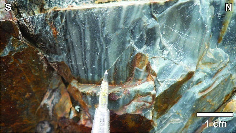
The rock is aphanitic to medium grained. In thin section, the rock has millimetric (≤2%, <1-2 mm) plagioclase phenocrysts pseudomorphosed in epidote, chlorite or actinolite and uralitized pyroxene. The matrix consists of plagioclase microlites transformed into a chlorite-epidote ± albite ± carbonate ± titanite assemblage. The amygdaloidal texture is common and up to 20% of calcite amygdules are millimetric and locally showing a vermicular appearance. Amygdules composed of calcite and ankerite (2-3 mm) are concentrated on pillow margins and are deformed in the regional schistosity plane. Interstitial space between pillows is filled with hyaloclastic material altered in calcite, quartz and feldspar. These minerals are also found in millimetric veins cutting the lavas. Locally, rusty alteration indicates the presence of sulphides, usually pyrite.
In deformation corridors, pillow basalts are transformed into chlorite-sericite schist with interpillow material altered in ankerite. The brecciated facies normally represents a minor portion (<1%) of flows, except in a few areas where breccia thickness reaches more than 40 m. These thicker breccia zones contain light green angular fragments 2-10 cm in diameter. They are characterized by intense alteration associated with numerous veinlets of quartz, calcite, ankerite, chlorite and epidote, hematite and sulphides (PY-PO ± CP ± Au). Basalts in the northern part of the Houghton Pluton deformation aureole (sheet 32G14-200-0101) have a hornblende-garnet-plagioclase-quartz assemblage. These amphibolites have a banded structure formed by alternating hornblende or plagioclase-rich bands. Chlorite, epidote and magnetite alteration of hornblende indicates retrograde metamorphism to the greenschist facies.
Leclerc et al. (2011) showed that in the Lac Doré Complex area the base of the Bruneau Formation (see "Uppermost Gilman" in their paper) is particularly rich in magnesium compared to the rest of the unit, ranging from 7 to 12% MgO. This variation is also noted in the la Trêve Lake area, where unit nAbnu1 has been divided into two subunits (Daoudene and Beaudette, 2022; see lithogeochemistry) based on MgO content, trace element profile, and stratigraphic position: a magnesian tholeiitic basalt subunit (nAbnu1a) and a ferriferous tholeiitic basalt subunit (nAbnu1b). It should be noted that there are no criteria for distinguishing them in the field.
Bruneau Formation 1a (nAbnu1a): Magnesian Tholeiitic Basalt and Amphibolite
The magnesian tholeiitic basalt is distinguished from the iron tholeiitic basalt (below) by a higher concentration of MgO (7-9%) and slightly lower concentrations of Al, Fe, Ti, rare earth elements and trace elements (Daoudene and Beaudette, 2022).
Bruneau Formation 1b (nAbnu1b): Ferriferous Tholeiitic Basalt and Amphibolite
The ferriferous tholeiitic basalt is distinguished from the magnesian tholeiitic basalt by a slightly higher concentration of Al, Fe, Ti, rare earths and trace elements, and a lower concentration of MgO, between 4 and 7% (Daoudene and Beaudette, 2022).
In the la Trêve Lake area, the magnetic map shows that the Bruneau Formation corresponds to a zone of low magnetic susceptibility without distinctive textures. The strong linear magnetic anomaly of the Abitibi Dyke somewhat obscures the pattern of the Bruneau Formation. Numerous electromagnetic anomalies are present within the unit.
Bruneau Formation 2 (nAbnu2): Mafic to Felsic Volcaniclastic Rocks, Rhyodacite, Rhyolite and Iron Formation
The Bruneau Formation contains a small proportion (1%) of volcaniclastic rocks (coarse to fine-lapilli tuff) and rhyodacite grouped in unit nAbnu2. These rocks consist of thin lenses (usually <10 m wide) with limited lateral extent (<500 m long), interstratified with mafic volcanic rocks. At the Bruneau Mine, one of these lenses is cut at the base by a gabbroic sill where the medium-lapilli tuff outcrops over an estimated thickness of 5 m. In thin section, glass shards are preserved in the chlorite ± sericite matrix. In outcrop, the white colour of lapilli suggests an intermediate composition. The tuff is overlaid by two beds of iron formation (95% magnetite, 5% pyrite, chalcopyrite traces) 40 and 80 cm thick respectively, separated by 2 m of bedded chert. These ferriferous layers can be tracked laterally over two outcrops located a few hundred metres apart, but the presence of gabbro sills precludes an estimate of their regional extent. The top of the Bruneau Mine sequence is characterized by the reoccurrence of pillow mafic volcanic rocks. To the west of the Gwillim Mine (sheet 32G16-200-0201), a medium-lapilli tuff lens measuring a few tens of metres long is also associated with an exhalative pyritic chert layer (Bouchard, 1986). In the Dolomieu Lake (sheet 32G14-200-0102) and Deux Orignaux Lake (sheet 32G14-200-0101) areas, the quartz-plagioclase-epidote-chlorite matrix lapilli tuff forms decametre-thick lenses. The lapilli essentially consist of plagioclase crystals elongated in the regional schistosity plane. Black chlorite replaces some of devitrified glass shards.
Thickness and Distribution
The Bruneau Formation thickness ranges between 2 and 3 km. This unit appears on the flanks of the Waconichi Syncline, Chibougamau Syncline and Chibougamau Anticline, from west of Chapais (sheets 32G14 and 32J03) to the Grenville Front Tectonic Zone (sheets 32H13 and 32I04).
Dating
A sample of medium to coarse-lapilli tuff collected in unit nAbnu2 at the emergency exit of the Bruneau Mine (outcrop 2006-FL-6129) sets the age of volcanism at 2724.4 ±1.2 Ma (Davis et al., 2014).
| Unit | Sample Number | Isotopic System | Mineral | Crystallization Age (Ma) | (+) | (-) | Reference(s) |
| nAbnu2 | 2006-FL-6129C | U-Pb | Zircon | 2724.4 | 1.2 | 1.2 | Davis et al., 2014 |
Stratigraphic Relationship(s)
On the northern flank of the Chibougamau Anticline (northern part of sheet 32G16), the Bruneau Formation base consists of pillowed volcanic rocks that overlie lapilli tuffs and rhyodacites of the Waconichi Formation's Allard Member. The unit’s upper contact is usually obscured by a shear zone located at the base of the Roberge and Ventures sills. However, west of Blondeau Lake, along Road 167 (sheet 32G16-200-0202), massive and pillowed flows of the Bruneau Formation are overlaid by variolitic lava forming the base of the Blondeau Formation. On the southern flank of the Chibougamau Anticline (sheets 32G09-200-0201, 32G09-200-0202 and 32G10-200-0202), effusive rocks of the Bruneau Formation conformably lie on volcaniclastic rocks of the Waconichi Formation (Queylus, Andy, Chevrier, and Îles members). In the same area, the unit’s sommital contact is truncated by the Kapunapotagen Shear Zone, except in the Dollier Lake area (sheet 32G09-200-0202) where mafic volcanic rocks are overlain by volcanic and sedimentary rocks of the Blondeau Formation (Daigneault, 1986; Roy et al., 2007). However, the low density of outcrops does not indicate the nature of contact at this location.
In the Waconichi Lake area (sheets 32J01 and 32I04), rocks of the Bruneau Formation form two strips on the flanks of the Waconichi Syncline. On the northern flank of the syncline, basal contact of the Bruneau Formation with rocks of the Obatogamau Formation is sharp. The top of the unit is cut by an E-W shear zone which hides the stratigraphic contact with sedimentary rocks of the Chebistuan Formation. South of the Waconichi Syncline, the Bruneau Formation overlies volcaniclastic rocks of the Waconichi Formation's Allard Member (Bélanger, 1979; Marchand, 1990).
In the Deux Orignaux Lake area west of Chapais (sheet 32G14), the Bruneau Formation forms three distinct strips: from south to north, the Dolomieu Lake strip, Chaleur Lake strip and Julien Lake strip. The Dolomieu Lake strip, on the south side of the Chapais Syncline, is not more than 2 km wide and extends laterally over all of sheets 32G14-200-0101 and 32G14-200-0102, south of the Misérables and Dolomieu lakes. The base of the unit, south of Dolomieu Lake, is an E-W reverse shear zone located on the top of Queylus Member rocks (Waconichi Formation). To the west of Misérables Lake, the basal contact of the Bruneau Formation is hidden by the Houghton Pluton intrusive rocks. The Bruneau Formation’s sommital contact with the Blondeau Formation corresponds to an E-W south-dipping reverse shear zone that passes through Misérables and Dolomieu lakes.
Northeast of Deux Orignaux Lake (sheet 32G14-200-0202), in the axial part of the Chibougamau Anticline, the Bruneau Formation's basal contact with volcaniclastic rocks of the Deux Orignaux Member (Waconichi Formation) is hidden by the intrusion of a kilometre-thick gabbroic sill. West of Armada Lake (NE of sheet 32G14-200-0102), mafic volcanic rocks at the top of the Bruneau Formation (unit nAbnu1) are in sharp contact with mafic to intermediate lapilli and block tuffs of the Blondeau Formation (unit nAbl). East of Chaleur Lake, on the north side of the Chibougamau Anticline and north of the Opémisca Pluton (NE of sheet 32G14-200-0202), the Bruneau Formation is in sharp contact with the Blondeau Formation. South of Chaleur Lake, the unit's upper contact corresponds locally to an angular discordance overlain by a thin lens of sedimentary rocks attributed to the Lac la Trêve Formation (Durocher, 1979).
The Julien Lake strip, located in the Waconichi Syncline, extends from the north of Trêve Lake (sheet 32G14-200-0201) to the south of Eau Noire Lake (sheet 32J03-200-0102). To the north, a thick differentiated gabbro sill and the Moraine Stock syenite intrude into the contact between rocks of the Obatogamau and Bruneau formations. East of la Trêve Lake, the summital contact of the Bruneau Formation with the sedimentary rocks of the Lac la Trêve Formation is also a thick differentiated sill and is taken up by a north-dipping reverse shear zone whose trace has been interpreted using aeromagnetic data and a few outcrops that indicate an increase in the intensity of the deformation towards the contact. The Bruneau and Lac la Trêve formations are in direct contact only over a very short distance SE of Julien Lake.
In sheet 32G13, the Bruneau Formation forms an E-W band that extends 34 km from the central part of la Trêve Lake to ~8 km west of Bransat Lake. The width of this band varies from 1.5 km to 4.5 km, but increases towards the west and reaches 6.5 km in the NW corner of sheet 32G13. Contacts to the north with the Waconichi (nAwa) and Obatogamau (nAob1b, nAob1c, nAob2) formations, and to the south with the Blondeau Formation (nAnl2), were not observed in the field. To the east and SW, the Bruneau Formation is bounded by the Dussault Shear Zone.
In the eastern part of sheet 32J03, the contact between the Bruneau and Chebistuan formations is interpreted as an unconformity, but this was not observed in the field due to a lack of outcrop.
Paleontology
Does not apply.
References
Publications available through SIGÉOM Examine
DAIGNEAULT, R., 1986. Géologie de la partie nord-est du canton de Dollier - Région de Chibougamau. MRN; DV 85-19, 1 plan.
DAOUDENE, Y., BEAUDETTE, M., 2022. Géologie de la région du lac la Trêve, Sous-province d'Abitibi, Eeyou Istchee Baie-James, Québec, Canada. MERN; BG 2022-04, 1 plan.DAVIS, D.W., SIMARD, M., HAMMOUCHE, H.,
BANDYAYERA, D., GOUTIER, J., PILOTE, P., LECLERC, F., DION, C., 2014. Datations U-Pb effectuées dans les provinces du Supérieur et de Churchill en 2011-2012. MERN, GEOCHRONOLOGICAL LABORATORY; RP 2014-05, 62 pages. Disponible à https://gq.mines.gouv.qc.ca/documents/EXAMINE/RP201405.
DAVID, J., SIMARD, M., BANDYAYERA, D., GOUTIER, J., HAMMOUCHE, H., PILOTE, P., LECLERC, F., DION, C., 2012. Datations U-Pb effectuées dans les provinces du Supérieur et de Churchill en 2010-2011. MRNF; RP 2012-01, 33 pages.
DAVID, J., SIMARD, M., BANDYAYERA, D., GOUTIER, J., HAMMOUCHE, H., PILOTE, P., LECLERC, F., DION, C., 2013. U-PB DATING IN THE SUPERIOR AND CHURCHILL PROVINCES, 2012-2011. MRN; RP 2012-01(A), 2 pages.
DAVID, J., PILOTE, P., HAMMOUCHE, H., LECLERC, F., TALLA TAKAM, F., 2018. Datations U-Pb dans la Province du Supérieur effectuées au GEOTOP en 2013-2014. MRN, GEOTOP; RP 2017-03, 43 pages.
DUROCHER, M., 1979. Canton d'Opémisca et quart nord-ouest du canton de Cuvier - Rapport intérimaire. MRN; DP 611, 34 pages, 1 plan.
ROY, P., FALLARA, F., HOULE, P., CHENG, L.Z., RABEAU, O., BLAIS, A., LAFRANCE, B., LECLERC, F., PILOTE, P., RIVERIN, G., SCHMITT, L. 2007. Étude sur le flanc sud du Complexe du Lac Doré, Chibougamau: stratigraphie, veines Cu-Au et modèle 3D préliminaire. In: MRNF, 2007. Résumés des conférences et des photoprésentations, Québec Exploration 2007. DV 2007-04, page 37.
Other publications
BÉLANGER, J., 1979. Étude de la zone de transition entre la Formation de Waconichi et la Formation de Gilman, Groupe de Roy, Chibougamau, Québec. Université du Québec à Chicoutimi; mémoire de maîtrise, 83 pages. constellation.uqac.ca/1832
BOUCHARD, G., 1986. Environnement géologique du gisement aurifère de la mine Gwillim. Université du Québec à Chicoutimi; mémoire de maîtrise, 88 pages, 2 plans. constellation.uqac.ca/1714
LECLERC, F., BÉDARD, J.H., HARRIS, L.B., GOULET, N., HOULE, P., ROY, P., 2008. Nouvelles subdivisions de la Formation de Gilman, Groupe de Roy, région de Chibougamau, Sous-province de l’Abitibi, Québec : résultats préliminaires. Dans : Recherches en cours. Commission géologique du Canada; 2008-07, 20 pages. doi.org/10.4095/226211
LECLERC, F., BÉDARD, J.H., HARRIS, L.B., MCNICOLL, V., GOULET, N., ROY, P., HOULE, P., 2011. Tholeiitic to calc-alkaline cyclic volcanism in the Roy Group, Chibougamau area, Abitibi Greenstone Belt – Revised stratigraphy and implications for VHMS exploration. Canadian Journal of Earth Sciences; volume 48, pages 661-694. doi.org/10.1139/E10-088
LEGAULT, M., 2003. Environnement métallogénique du couloir de Fancamp avec emphase sur les gisements aurifères de Chevrier, région de Chibougamau, Québec. Université du Québec à Chicoutimi; thèse de doctorat, 488 pages. constellation.uqac.ca/811
MARCHAND, K., 1990. Étude d’éléments structuraux dans la demie nord du canton de McKenzie, Chibougamau. Université du Québec à Chicoutimi; mémoire de maîtrise, 123 pages, 5 plans. constellation.uqac.ca/1585
MORTENSEN, J.K., 1993. U-Pb geochronology of the eastern Abitibi subprovince. Part 1: Chibougamau – Matagami – Joutel region. Canadian Journal of Earth Sciences; volume 30, pages 11-28. doi.org/10.1139/e93-002
TRUDEAU, Y., 1981. Pétrographie et géochimie des roches du secteur environnant de la mine Bruneau, Chibougamau, Québec. Université du Québec à Chicoutimi; mémoire de maîtrise, 136 pages, 1 plan. constellation.uqac.ca/1810
Suggested Citation
Ministère de l’Énergie et des Ressources naturelles (MERN). Bruneau Formation. Quebec Stratigraphic Lexicon. https://gq.mines.gouv.qc.ca/lexique-stratigraphique/province-du-superieur/formation-de-bruneau_en [accessed on Day Month Year].
Contributors
|
First publication |
François Leclerc, P. Geo., Ph.D. francois.leclerc@mern.gouv.qc.ca (redaction) Mehdi A. Guemache, P. Geo., Ph.D. (coordination); Claude Dion, Eng., M.Sc. (critical review); Simon Auclair, P. Geo., M.Sc. (editing); Céline Dupuis, P. Geo., Ph.D. (English version); Nathalie Bouchard (HTML editing). |
|
Revision(s) |
Mélanie Beaudette, P. Geo., M.Sc., melanie.beaudette@mern.gouv.qc.ca; Yannick Daoudene, P. Geo., Ph.D., yannick.daoudene@mern.gouv.qc.ca (redaction) Mehdi A. Guemache, P. Geo., Ph.D. (coordination); James Moorhead, P. Geo., M.Sc. (critical review); Simon Auclair, P. Geo., M.Sc. (editing); Dominique Richard, GIT, Ph.D. (English version); André Tremblay (HTML editing). |