


Last modified: 31 October 2022
DISCLAIMER: This English version is translated from the original French. In case of any discrepancy, the French version shall prevail.
| Author(s): | Moukhsil and Doucet, 1999 |
| Age: | Neoarchean |
| Stratotype: | None |
| Type area: | Village Lakes area (NTS sheet 33B03) |
| Geological province: | Superior Province |
| Geological subdivision: | La Grande Subprovince |
| Lithology: | Volcano-sedimentary rocks |
| Category: | Lithostratigraphic |
| Rank: | Formation |
| Status: | Formal |
| Use: | Active |
- Eastmain Group
- Prosper Formation
- Auclair Formation
- Low Formation
- Clarkie Formation
- Anaconda Formation
- Wabamisk Formation
- Komo Formation
- Kasak Formation
- Bernou Formation
- Pontax Formation
- Anatacau-Pivert Formation
- Pilipas Formation
- Natel Formation
- Kauputauch Formation
Background
The first descriptions of these lithologies come from the works of Carlson (1962), Hashimoto (1962), Eakins et al. (1968), Bourne (1972), Remick and Ahmedali (1974), Valiquette (1975), Dubé (1978), and Franconi (1976, 1978, 1983). Simard and Gosselin (1999) later grouped rocks of this unit and metasedimentary rocks of the Opinaca Subprovince under the name “Laguiche Group”. The name Auclair Formation was introduced by Moukhsil and Doucet (1999) to describe a metasedimentary-dominated unit in the Village Lakes area (sheet 33B03), which is part of the Lower Eastmain River Volcano-Sedimentary Band (LERVB). The Auclair Formation is named after a former Hydro-Québec camp (Auclair Camp). It was then mapped by Moukhsil (2000), Moukhsil et al. (2001) and Moukhsil and Legault (2002) west of the Village Lakes area.
In the work of Moukhsil et al. (2003) on the geology of the Middle and Lower Eastmain Greenstone Belt (MLEGB), the Auclair Formation encompassed both paragneiss of the Opinaca and Nemiscau metasedimentary basins, as well as some of the Eastmain Group sedimentary formations in the La Grande Subprovince.
During subsequent synthesis and mapping work, some areas of the Auclair Formation were removed and redistributed to other units according to their respective subprovince. The migmatized paragneisses of the Opinaca Subprovince were reassigned to the Laguiche Complex (Bandyayera and Fliszár, 2007). The migmatized paragneisses of the Nemiscau Subprovince have been grouped under the name “Rupert Complex” (Bandyayera and Daoudene, 2018), while paragneisses in the Lac des Montagnes Belt were assigned to the Voirdye Formation (Bandyayera and Caron-Côté, 2019). The rocks belonging to the Auclair Formation south of the MLEGB, and mapped by Moukhsil (2000), Moukhsil et al. (2001) and Moukhsil and Legault (2002), were assigned to the Jolicoeur Complex in the context of the geological synthesis of the Nemiscau Subprovince (Bandyayera et al., 2022)
As a result, the Auclair Formation now encompasses only a portion of the sedimentary rocks of its original definition, limiting it to those spatially associated with the volcanic and volcaniclastic rock sequences of the Eastmain Group in the La Grande Subprovince.
Côté-Roberge et al. (2021) refined the unit contacts in sheets 33B02 and 33B03 after 1:50 000 mapping in the Conviac Lake area.
Description
The Auclair Formation consists mainly of paragneiss with several metamorphic mineral assemblages. It also contains layers of volcanic and volcaniclastic rocks of intermediate to felsic composition. It was subdivided by Moukhsil and Doucet (1999) into four units: 1) paragneiss (nAai1); 2) oxide facies iron formation (nAai2); 3) andesite, rhyolite, rhyodacite, and lapilli and block tuffs (nAai3); and 4) polymictic conglomerate (nAai4). The degree of metamorphism of these rocks varies from greenschist facies to upper amphibolite facies (Moukhsil and Doucet, 1999; Moukhsil and Legault, 2002). The Auclair Formation contains several gold mineralizations associated with oxide or silicate facies Algoma-type iron formations (Chapdelaine, 1997; Lanthier and Ouellette, 1995; Moukhsil and Doucet, 1999; Moukhsil et al., 2003).
Auclair Formation 1 (nAai1): Paragneiss
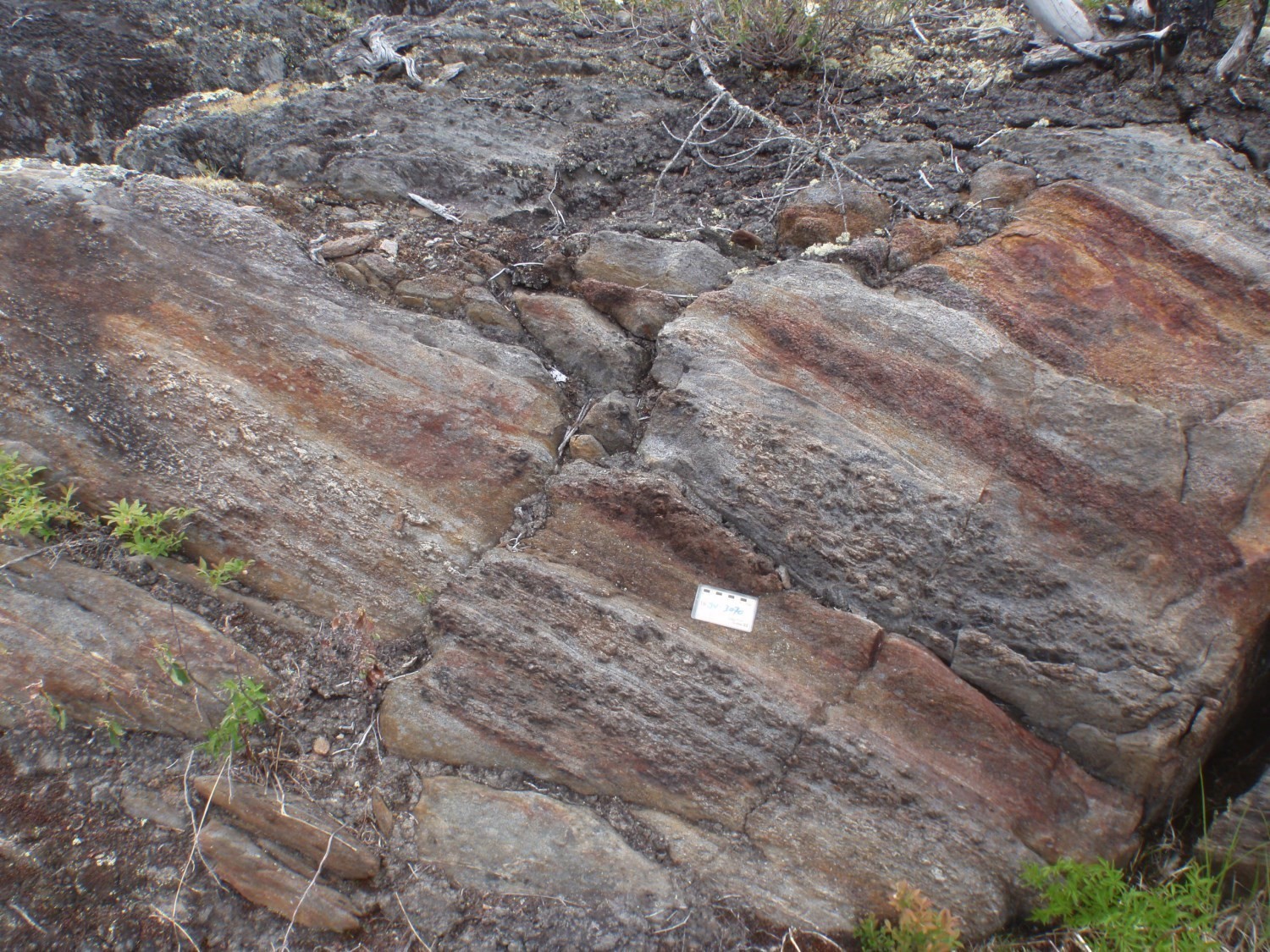
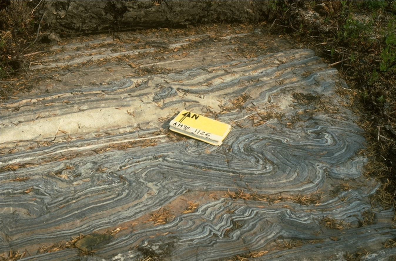
Unit nAai1 represents the main unit of the Auclair Formation. It consists essentially of a paragneiss with the following metamorphic mineral assemblages: (a) biotite-sillimanite-cordierite; (b) biotite-garnet-staurotide-kyanite-fibrous sillimanite; (c) biotite-garnet-staurotide-kyanite; (d) biotite-andalusite-garnet. However, these facies are very difficult to map as distinct lithological units (Moukhsil and Doucet, 1999; Moukhsil, 2000). Paragneiss is fine to medium grained, dark grey to bluish on a fresh surface and rusty brown on an altered surface. Its protolith is sedimentary and includes sandstone beds, argillaceous layers and feldspathic wacke (Moukhsil and Doucet, 1999). The rock has a porphyroblastic to interlobate granoblastic structure (Moukhsil, 2000). Porphyroblasts correspond to aluminosilicate nodules composed of cordierite, andalusite, staurotide or sillimanite. These nodules are in positive relief in outcrop and can be a few centimetres in diameter (Franconi, 1983; Moukhsil and Doucet, 1999). They highlight strong banding defined by alternating centimetric bands (20-30 cm) rich in aluminosilicates and bands lacking them (Franconi, 1983).
Some beds are strictly composed of cordierite, while others contain only staurotide. Cordierite porphyroblasts are subcircular (Franconi, 1978, 1983), while staurotide porphyroblasts are light brown and have an undefined but angular shape (Eakins et al., 1968). Sillimanite is fibrous or in elongated whitish millimetric clusters. Fibrous sillimanite and cordierite are observed in places, especially in the eastern part of the unit (Moukhsil, 2000; Côté-Roberge et al., 2021). Andalusite forms quadrangular grey-pink porphyroblasts with edges reaching several centimetres (4-7 cm) (Franconi, 1983; Moukhsil and Doucet, 1999). Garnet forms euhedral crystals, locally the size of andalusite (Moukhsil and Doucet, 1999). The biotite-andalusite-garnet lithofacies appears to be a marker bed for the iron formations (nAai2) (Franconi, 1983; Moukhsil and Doucet, 1999). The outcrops of this lithofacies may extend over several kilometres. It is composed of 45% quartz, 30% biotite and 10-25% andalusite porphyroblasts. Garnet can form up to 10% of the rock. In some places, this lithofacies presents a very strong schistose flow, marked by the alignment of andalusite (Moukhsil and Doucet, 1999).
In thin section, unit nAai1 is typically composed of 28-40% quartz, 20-30% biotite, 15-30% plagioclase and 1-3% garnet (Moukhsil, 2000; Côté-Roberge et al., 2021). Porphyroblastic phases can have 14 to 18% andalusite and 10 to 15% staurotide (Moukhsil, 2000). Andalusite porphyroblasts are poikilitic with abundant quartz inclusions, small biotite lamellae and some sillimanite crystals. These porphyroblasts are rimmed with biotite and sit in a fine-grained matrix of quartz, plagioclase and biotite crystals. Sillimanite occurs in clusters of long fibres with biotite or in isolated nodules, ovoids, consisting of fine needle imbrication (Franconi, 1983). Staurotide porphyroblasts have a sieve texture and occur as euhedral crystals, stretched anhedral masses or large crystals with cruciform twinning (Eakins et al., 1968; Franconi, 1978). Cordierite forms anhedral masses generally pinitized (Franconi, 1978). Garnet occurs as euhedral crystals or as pink poikiloblastic porphyroblasts (Eakins et al., 1968; Franconi, 1983). Accessory minerals are opaque minerals, epidote, muscovite, graphite, apatite, tourmaline, chlorite and pyrite (Eakins et al., 1968; Franconi, 1983; Moukhsil, 2000).
In the Village Lakes area, a few biotite paragneiss enclaves also show orthopyroxene. These rocks may have been removed from the Laguiche basin during the emplacement of the Village Batholith (Moukhsil and Doucet, 1999).
Auclair Formation 2 (nAai2): Oxide Facies Iron Formation
Unit nAai2 consists mainly of oxide and locally silicate and sulphide facies iron formations (Moukhsil and Doucet, 1999). The oxide iron formation is interstratified in unit nAai1 paragneiss. It forms one or more conformable layers ranging from a few metres to ~40 m thick, which are systematically associated with andalusite-garnet pelitic paragneiss (Franconi, 1983; Moukhsil and Doucet, 1999). Lateral changes in facies and thickness (primary) are noted (Chapdelaine, 1997). The oxide facies iron formation has a rusty patina and a banded appearance that is marked by alternating centimetric chert beds, dark blue on a fresh surface, and beds (≤10 cm) of fine-grained magnetite (Franconi, 1983; Moukhsil and Doucet, 1999). South of Béryl Lake, iron formations locally contain garnet, which may be an alteration product (metasomatism; Moukhsil and Doucet, 1999). Gabbro sills (unit nAgdi3 of the Moyenne Eastmain Gabbro and Diorite) are associated with these iron formations (Moukhsil and Doucet, 1999).
In thin section, the oxide facies iron formation consists of 25-50% iron oxides, 30-40% quartz, 20-30% feldspar and 20-30% biotite (Côté-Roberge et al., 2021). These proportions vary greatly from one bed to another within the same sample.
Auclair Formation 3 (nAai3): Andesite, Rhyolite, Rhyodacite and Lapilli and Block Tuff
This unit consists of a few layers of andesite, rhyolite, rhyodacite and intermediate to felsic lapilli and block tuffs (Moukhsil and Doucet, 1999; Moukhsil, 2000). Lapilli tuffs form metre-thick layers with a dark grey alteration patina. They are fine grained, locally porphyritic and contain anhedral plagioclase phenocrysts (5-7%, 1-3 mm in diameter). Tuffs also contain up to 50% of small grains of sericitized plagioclase in the matrix (Moukhsil and Doucet, 1999). In thin section, the main minerals observed are quartz (35%), biotite (5%) and actinolite (8%). Quartz is polygonal. Brown biotite is anhedral and moderately to highly chloritized. Actinolite occurs as coarse subhedral to anhedral poikilitic grains. Accessory minerals are epidote (1%) and small angular grains of opaque minerals (1%). Tuffs are deformed and the schistosity is highlighted by the alignment of biotite and actinolite (Moukhsil and Doucet, 1999).
Auclair Formation 4 (nAai4): Polymictic Conglomerate

This unit is not very widespread and is usually located along volcanic packages (Franconi, 1983). The stratigraphic position of this unit appears ambiguous. Moukhsil and Doucet (1999) mention that the conglomerate occupies the summital part of the Auclair Formation. Nevertheless, they note that the Auclair Formation stratigraphically overlies the Natel Formation, which is supported by polarities towards the NE observed in the field. Conglomerates are located at the interface of the Natel and Auclair formations, suggesting that they would instead correspond to basal conglomerates.
This unit consists of garnet-rich polymictic conglomerate composed of >90% pebbles and <10% highly chloritized matrix. Fragments are very stretched and include different lithologies: quartzite and/or rhyolite, basalt and amphibolite, tonalite to granodiorite, and biotite paragneiss. Quartzite and/or rhyolite fragments are up to 20 cm in diameter and form up to 20% of the rock. Basalt and amphibolite fragments (2-15 cm in diameter) are highly deformed and account for 15% of the rock. Tonalitic to granodioritic fragments are 10 to 25 cm in diameter and form 40% of the rock. They could come from one or more synvolcanic plutons. Biotite paragneiss fragments are 2 to 4 cm in diameter and form 25% of the rock. Some channel sedimentary structures are recognized. However, the intensity of deformation precludes establishing polarity (Moukhsil and Doucet, 1999).
Thickness and Distribution
The Auclair Formation extends discontinuously over ~150 km in the MLEGB. The largest mass belonging to this formation is found in the Village lakes area (sheet 33B03; Moukhsil and Doucet, 1999) and to a lesser extent in adjacent sheets 33B04, 32O14 and 33B02. In this area, the Auclair Formation forms a strongly arcuate strip, the convexity of which points to the ENE. This strip reaches a length of 35 km by an average width of 6 km. A solitary ovoid mass 4 km long, with a particularly complex structure, is present in sheet 33B02. It is distinguished by its strong magnetic contrast due to the presence of unit nAai2.
The Auclair Formation also outcrops in sheets 33C01, 33C02, 33C06, 33C07 and 33C08. In these sheets, it generally appears as a lens 1 to 7 km long and 0.2 to 1.5 km wide. The paragneiss with metamorphic minerals (nAai1) represents the most important unit. The other units (nAai2, nAai3 and nAai4) are located only in the Village lakes area (sheets 33B03 and 32O14). They cover smaller areas and are not as thick.
According to Franconi (1978), the thickness of Auclair Formation paragneiss is not very large and possibly duplicated by folding.
Dating
None.
Stratigraphic Relationship(s)
The Auclair Formation corresponds to the youngest period of Archean sedimentary activity in the MLEGB (Boily and Moukhsil, 2003; Moukhsil et al., 2003). It is interpreted by Moukhsil et al. (2003) as part of the second period of sedimentation of the MLEGB. It is possible that the Auclair Formation is the same age as the uppermost part of the Wabamisk Formation and the Anaconda and Clarkie formations, corresponding to the first period of sedimentation of the MLEGB.
The Auclair Formation constitutes the top of the Eastmain Group volcano-sedimentary sequence (Moukhsil and Legault, 2002). The transition from paragneisses of the Auclair Formation to volcanic rocks of the La Grande Subprovince is marked by a stratigraphic contact (Goutier et al., 1999; Moukhsil, 2000; Moukhsil et al., 2001; Moukhsil and Legault, 2002). In the Village lakes area (sheet 33B03), the Auclair Formation overlies conformably the Natel Formation (Moukhsil and Doucet, 1999). To the west, it is stratigraphically overlying the Wabamisk or Komo formations (Moukhsil, 2000; Moukhsil et al., 2001) and separated from the Jolicoeur Complex by the Causabiscau Shear Zone (Bandyayera et al., 2022). To the east, the Auclair Formation overlaps the Village Batholith (2720 to 2700 ±2 Ma; Moukhsil, 2000) and is in inferred contact with the probably younger Prosper Formation (Côté-Roberge et al., 2021).
Several post-tectonic to late-tectonic intrusions, such as the Pacific Intrusive Suite, cut the Auclair Formation (Moukhsil and Doucet, 1999; Moukhsil et al., 2003; Côté-Roberge et al., 2021). Small masses of syntectonic to late-tectonic gabbro, belonging to the Moyenne Eastmain Gabbro and Diorite unit, are also intruding into the metasedimentary rocks of the Auclair Formation (Moukhsil, 2000; Moukhsil and Legault, 2002).
Paleontology
Does not apply.
References
Publications Available through SIGÉOM Examine
BANDYAYERA, D., CARON-CÔTÉ, E., 2019. Géologie de la région du lac des Montagnes, sous-provinces de La Grande, de Nemiscau et d'Opatica, Eeyou Istchee Baie-James, Québec, Canada. MERN; BG 2019-03, 1 plan.
BANDYAYERA, D., CARON-CÔTÉ, E., PEDREIRA, R. P., CÔTÉ-ROBERGE, M., CHARTIER-MONTREUIL, W. 2022. Synthèse géologique de la Sous-province de Nemiscau, Eeyou Istchee Baie-James, Québec, Canada. MERN; BG 2021-03, 1 plan.
BANDYAYERA, D., DAOUDENE, Y. 2018. Géologie de la région du lac Nemiscau, secteur ouest de la rivière Rupert (SNRC 32N06, 32N07 et 32N11). MERN; RG 2018-03, 58 pages et 1 plan.
BANDYAYERA, D., FLISZAR, A. 2007. Géologie de la région de la baie Kasipasikatch et du lac Janin. MRNF; RP 2007-05, 15 pages et 2 plans.
BOILY, M., MOUKHSIL, A. 2003. GEOCHIMIE DES ASSEMBLAGES VOLCANIQUES DE LA CEINTURE DE ROCHES VERTES DE LA MOYENNE ET DE LA BASSE-EASTMAIN, PROVINCE DU SUPERIEUR, QUEBEC. MRN; ET 2002-05, 31 pages.
BOURNE, J H. 1972. GEOLOGY OF THE MESGOUEZ LAKE AREA (ABITIBI, MISTASSINI AND NEW QUEBEC TERRITORIES). MRN; DP 110, 14 pages et 1 plan.
CARLSON, E H. 1962. Rapport préliminaire sur la région du lac Pivert, Territoire de Mistassini et Nouveau-Québec. MRN; RP 483, 13 pages et 1 plan.
CARLSON, E H., EAKINS, P R., HASHIMOTO, T. 1968. REGION DE GRAND-DETOUR - LACS VILLAGE, TERRITOIRE DE MISTASSINI ET NOUVEAU-QUEBEC. MRN; RG 136, 53 pages et 3 plans.
CHAPDELAINE, M. 1997. RAPPORT TECHNIQUE DES TRAVAUX, PROJET AUCLAIR. MINES D'OR VIRGINIA INC. Rapport statutaire soumis au gouvernement du Québec. GM 55428, 113 pages et 7 plans.
CÔTÉ-ROBERGE, M., CHARTIER-MONTREUIL, W., HAMEL-HÉBERT, M.-K., BANDYAYERA, D., 2021. Géologie de la région du lac Conviac, sous-provinces d'Opinaca et de La Grande, Eeyou Istchee Baie-James, Québec, Canada. MERN; BG 2022-05, 1 plan.
DUBE, C. 1978. Région des lacs Champion, Tésécau et de la rivière Rupert (territoire de Mistassini et d'Abitibi) ? compilation. MRN; DPV 585, 39 pages et 2 plans.
FRANCONI, A. 1976. Géologie de la partie est de la bande volcanosédimentaire de la rivière Eastmain inférieure (territoires de Mistassini et du Nouveau-Québec). MRN; DPV 450, 27 pages et 2 plans.
FRANCONI, A. 1983. REGION DE LA GORGE PROSPER. MRN; MM 82-02, 69 pages et 5 plans.
FRANCONI, A.1978. La bande volcanosédimentaire de la rivière Eastmain inférieure - rapport géologique final. MRN; DPV 574, 186 pages et 2 plans.
HASHIMOTO, T. 1962. RAPPORT PRELIMINAIRE SUR LA REGION DES LACS VILLAGE, TERRITOIRE DE MISTASSINI ET NOUVEAU-QUEBEC. MRN; RP 473, 12 pages et 1 plan.
LANTHIER, G., OUELLETTE, J F. 1995. RAPPORT DES TRAVAUX 1994-1995, PROPRIETE AUCLAIR. MINES D'OR VIRGINIA INC, EXPLORATIONS DIABIOR INC. Rapport statutaire soumis au gouvernement du Québec. GM 53577, 35 pages et 4 plans.
MOUKHSIL, A. 2000. Géologie de la région des lacs Pivert (33C/01), Anatacau (33C/02), Kauputauchechun (33C/07) et Wapamisk (33C/08). MRN; RG 2000-04, 49 pages et 4 plans.
MOUKHSIL, A., DOUCET, P. 1999. GEOLOGIE DE LA REGION DES LACS VILLAGE. MRN; RG 99-04, 33 pages et 1 plan.
MOUKHSIL, A., LEGAULT, M. 2002. Géologie de la région de la Basse-Eastmain occidentale (33D/01, 33D/02, 33D/07 et 33D/08). MRN; RG 2002-09, 32 pages et 4 plans.
MOUKHSIL, A., VOICU, G., DION, C., DAVID, J., DAVIS, D.W., PARENT, M. 2001. Géologie de la région de la Basse-Eastman centrale (33C03, 33C04, 33C05 et 33C06). MRN; RG 2001-08, 54 pages et 4 plans.
REMICK, J. H., AHMEDALI, S. T. 1974. Cartes annotées de la région de Fort Rupert (Nouveau Québec). MRN; DP 274, 23 plans.
SIMARD, M., GOSSELIN, C. 1999. GEOLOGIE DE LA REGION DU LAC LICHTENEGER. MRN; RG 98-15, 27 pages et 1 plan.
VALIQUETTE, G. 1975. Région de la rivière Nemiscau. MRN; RG 158, 171 pages et 3 plans.
Other publications
Suggested Citation
Ministère de l’Énergie et des Ressources naturelles (MERN). Auclair Formation. Quebec Stratigraphic Lexicon. https://gq.mines.gouv.qc.ca/lexique-stratigraphique/province-du-superieur/formation-auclair_en [accessed on Day Month Year].
CONTRIBUTORS
|
First publication |
Charles St-Hilaire, GIT, M.Sc. charles.st-hilaire@mern.gouv.qc.ca; Emmanuel Caron-Côté, P. Geo., M.Sc. emmanuel.caron-cote@mern.gouv.qc.ca (redaction) Mehdi A. Guemache, P. Geo., Ph.D. (coordination); Patrice Roy, P. Geo., M.Sc. (critical review); Simon Auclair, P. Geo., M.Sc. (editing); Céline Dupuis, P. Geo., Ph.D. (English version); Ricardo Escobar Moran (HTML editing). |
|
Revision(s) |
Emmanuel Caron-Côté, P. Geo., M.Sc.; Daniel Bandyayera, P. Geo., Ph.D. daniel.bandyayera@mern.gouv.qc.ca (redaction; 9 December 2021) Mehdi A. Guemache, P. Geo., Ph.D. (coordination); Abdelali Moukhsil, P. Geo., Ph.D. (critical review); Simon Auclair, P. Geo., M.Sc. (editing); Dominique Richard, GIT, Ph.D. (version anglaise); André Tremblay (HTML editing). |