Last modified:
Translation of original French
| Author: | Leclerc et al., 2011 |
| Age: | Neoarchean |
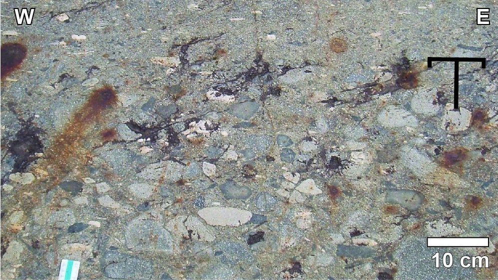
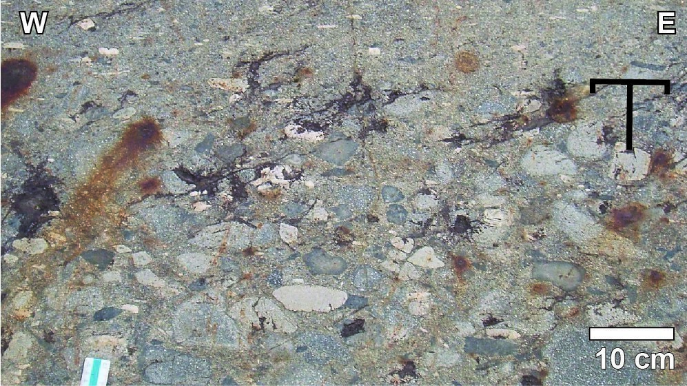
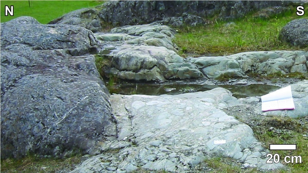
| Reference section: | The type locality of the Allard Member is Allard Park (NTS sheets 32G15 and 32G16, UTM NAD83, zone 18: 543809 mE, 5529518 mN). Volcaniclastic rocks form a sequence of sorted beds that repeat over a 25 m thickness (Leclerc et al., 2008). Decimetric beds consist of coarse to fine-lapilli tuff containing fragments that decrease in size and percentage towards the top (from 15 cm to <1 cm and 70% to <1%) |
| Type area: | The Allard Member outcrops from western Fleury Lake (sheet 32G15-200-0102) to the Taché Lake area (sheet 32G16-200-0202). It outcrops particularly well along Road 167, 6 km east of the town of Chibougamau |
| Geological province: | Superior Province |
| Geological subdivision: | Abitibi Subprovince |
| Lithology: | Mafic to felsic volcaniclastic rocks |
| Type: | Lithostratigraphic |
| Rank: | Member |
| Status: | Formal |
| Use: | Active |
- Roy Group
-
- Bordeleau Formation
- Ruisseau Dalime Formation
- Scorpion Formation
- Phooey Member
- Blondeau Formation
- Bruneau Formation
- Waconichi Formation
- Allard Member
- Scott Member
- Deux Orignaux Member
- Winchester Member
- Lemoine Member
- Portage Member
- Lacs Member
- Îles Member
- Coyote Member
- Chevrier Member
- Queylus Member
- Andy Member
- Obatogamau Formation
- Pichamobi Member
- Wachigabau Member
- David Member
Background
This unit was originally recognized as discontinuous lenses in the upper Gilman Formation north of the Chibougamau Pluton (Smith and Allard, 1960; Allard, 1976; McPhee and Winfield, 1976; Hamilton, 1977; Trudeau, 1981; Ludden et al., 1984; Couture, 1986; Daigneault and Allard, 1990). Recent mapping supported by lithogeochemistry and geochronology have shown that the transitional to calc-alkaline affinity unit has a lateral extent of >30 km and contemporary age to the Waconichi Formation (Leclerc et al., 2011). The Allard Member therefore formally designates this unit now integrated into the Waconichi Formation (Leclerc et al., 2011).
Description
Allar Member (nAard): Basaltic to Dacitic Volcaniclastic Rock, Andesite to Dacite, Laminated Metasedimentary Rock, Chert and Exhalite
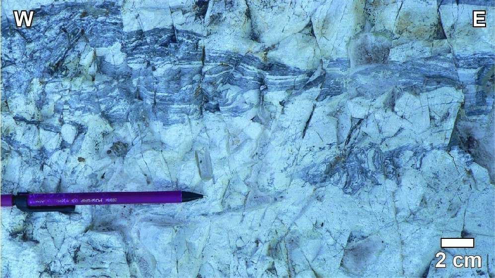
Unit nAard consists mainly of volcaniclastic rocks of basaltic to dacitic composition and includes a sommital portion locally characterized by a sequence of laminate metasedimentary rocks, pyritic chert and rhyodacite. Volcanilastic rocks form generally sorted sequences with fine-grained beds showing erosion channels, oblique laminations, folds and synvolcanic faults. Coarse to fine-lapilli tuffs are characterized by the presence of angular to subangular fragments in positive relief, stretched and flattened in the regional schistosity plane, and abundant chert and sulphide fragments. Fragments of black to green mafic volcanic rocks are aphyritic and fine grained, while beige to grey fragments are intermediate to felsic and contain >25% plagioclase phenocrystals. Some fragments of volcanic rocks also contain pyroxene phenocrystals altered to actinolite. When preserved, chert fragments are rectangular and oriented parallel to bedding. Rusty sulphide clasts consist of pyrite and pyrrhotine in a chert matrix. Fragments moulded on one another involve an emplacement at high temperature. Darker chilled margins of some of the fragments suggest a rapid cooling as they were deposited in volcanic ash.
The matrix of volcaniclastic rocks is grey to green and fine to medium grained. It is composed of a chlorite-sericite-carbonate assemblage and contains up to 25% millimetric plagioclase phenocrystals. In some areas, the high proportion of chlorite gives the matrix a dark green colour that contrasts with typically beige to white fragments. In places where sericite is the dominant mineral, the altered surface is commonly beige and is indicative of the presence of carbonate. Plagioclase crystal tuffs (20–25%, <1–5 mm) form beds a few centimetres thick when interbedded with lapilli tuff, but tuffs dominate the unit north of Gilman Lake and west of Proulx Bay (sheet 32G16-200-0201).
The summit of the Allard Member is particularly well exposed on a series of outcrops west of Proulx Bay (McPhee and Windfield, 1976; Trudeau, 1981). There, coarse-lapilli tuffs are overlaid by a light grey to white quartz porphyritic rhyodacite lens, estimated to be 450 m thick. At the top contact of the lens, there is a sequence of breccia and coarse-lapilli tuff of intermediate composition, chert-pyrite exhalite and turbidites consisting of siltstone and mudstone millimetric beds. The sequence is overlaid by felsic lava flows with laminar flow structure and characterized by intraformational folds and fragments whose shape suggests synvolcanic rotation.
Allar Member 1 (nAard1): Andesite and Dacite
The base of the Allard Member consists of a unit of andesite and dacite exhibiting massive, pillowed and brecciated structures and of transitional to calc-alkaline affinity. This unit is characterized by a light green to white patina, which distinguishes it from underlying volcanic rocks belonging to the David Member of dark green patina and tholeiitic affinity.
Thickness and Distribution
The unit’s thickness varies from 30 m northeast of Gilman Lake (sheet 32G16-200-0201) to >1000 m west of Lempira Lake (sheet 32G16-200-0202). Its average thickness is ~200 m. The unit extends from western Fleury Lake (sheet 32G15-200-0102) to the Taché Lake area (sheet 32G16-200-0202).
Dating
The analysis of a sample of medium-lapilli tuff from the upper section of Allard Park determined a crystallization age of 2726.6 ±0.7 Ma (TIMS–U-Pb on zircons; Leclerc et al,. 2011). This age is identical to that of a medium-lapilli tuff sample from an outcrop on Road 167 west of Proulx Bay (2726.7 ±0.7 Ma; Leclerc et al., 2011), and very similar to that of another medium-lapilli tuff sample from the Faribault logging area (2727.4 ±0.9 Ma; Leclerc et al., 2011).
| Isotopic System | Mineral | Crystallization Age (Ma) | (+) | (-) | Reference(s) |
| U-Pb | Zircon | 2726.6 | 0.7 | 0.7 | Leclerc et al., 2011 |
| U-Pb | Zircon | 2726.7 | 0.7 | 0.7 | Leclerc et al., 2011 |
| U-Pb | Zircon | 2727.4 | 0.9 | 0.9 | Leclerc et al., 2011 |
Stratigraphic Relationship(s)
West of Chibougamau (sheet 32G15), rocks of the Allard Member lie in sharp contact with those of the Scott Member, whereas in the Chibougamau area they overlie those of the David Member. In all cases, the Allard Member’s summit is characterized by a sharp contact with mafic volcanic rocks of the Bruneau Formation.
Paleontology
Does not apply.
References
| Author(s) | Title | Year of Publication | Hyperlink (EXAMINE or Other) |
|---|---|---|---|
| ALLARD, G.O. | Doré Lake Complex and its importance to Chibougamau geology and metallogeny. Ministère des Richesses naturelles, Québec; DPV 368, 446 pages, 2 plans. | 1976 | DPV 368 |
| COUTURE, J.-F. | Géologie de la Formation de Gilman dans la partie centrale du canton de Roy, Chibougamau, Québec. Université du Québec à Chicoutimi; master’s thesis, 151 pages. | 1986 | Source |
| DAIGNEAULT, R. – ALLARD, G.O. | Le Complexe du Lac Doré et son environnement géologique (région de Chibougamau – Sous-province de l’Abitibi). Ministère de l’Énergie, des Mines et des Ressources, Québec; MM 89-03, 275 pages. | 1990 | MM 89-03 |
| HAMILTON, W. | Progress, report, 1977 exploration program, Roy project, Main block. Campbell Chibougamau Mines, rapport statutaire déposé au ministère de l’Énergie et des Ressources naturelles, Québec; GM 33409, 75 pages, 80 plans. | 1977 | GM 33409 |
| LECLERC, F. – BÉDARD, J.H. – HARRIS, L.B. – GOULET, N. – HOULE, P. – ROY, P. | Nouvelles subdivisions de la Formation de Gilman, Groupe de Roy, région de Chibougamau, Sous-province de l’Abitibi, Québec : résultats préliminaires. Geological Survey of Canada; Current Researches 2008-7, 20 pages. | 2008 | Source |
| LECLERC, F. – BÉDARD, J.H. – HARRIS, L.B. – MCNICOLL, V. – GOULET, N. – ROY, P. – HOULE, P. | Tholeiitic to calc-alkaline cyclic volcanism in the Roy Group, Chibougamau area, Abitibi Greenstone Belt – Revised stratigraphy and implications for VHMS exploration. Canadian Journal of Earth Sciences; volume 48, pages 661–694. | 2011 | Source |
| LUDDEN, J.N. – FRANCIS, D.M. – ALLARD, G.O. | The geochemistry and evolution of the volcanic rocks of the Chibougamau region of the Abitibi metavolcanic belt. In: Chibougamau : stratigraphy and mineralization (Guha, J. and Chown, E.H., editors). Canadian Institute of Mining and Metallurgy; volume 34, pages 20-34. | 1984 | – |
| McPHEE, D.S. – WINDFIELD, B. | Geological report, Chibougamau, Quebec property. Rouanda Mining et Bruneau Mining, rapport statutaire déposé au ministère de l’Énergie et des Ressources naturelles; Québec; GM 32509, 63 pages, 7 plans. | 1976 | GM 32509 |
| SMITH, J.R. – ALLARD, G.O. | Moitié sud du canton de McKenzie, district électoral d’Abitibi-Est. Ministère des mines, Québec; RG 095, 71 pages, 2 plans. | 1960 | RG 095 |
| TRUDEAU, Y. | Pétrographie et géochimie des roches du secteur environnant de la mine Bruneau, Chibougamau, Québec. Université du Québec à Chicoutimi; master’s thesis, 136 pages, 1 plan. | 1981 | Source |


