DISCLAIMER: This English version is translated from the original French. In case of any discrepancy, the French version shall prevail.
| Author: | Beauchamp, 2020 |
| Age: | Neoarchean |
| Stratotype: | Outcrop 18-LP-6149, located in the centre of the MacLeod Batholith, is typical of this unit. |
| Type area: | Cadieux lake area (NTS sheets 33A02, 33A03 and 33A07) |
| Geological province: | Superior Province |
| Geological subdivision: | Opatica and Opinaca subprovinces |
| Lithology: | Granodiorite, quartz monzonite and granite |
| Category: | Lithodemic |
| Rank: | Lithodeme |
| Status: | Formal |
| Use: | Active |
None
Background
Based on data from the regional mapping campaigns of Hocq (1975, 1985), a strip of leucocratic biotite ± hornblende gneiss partially aligned with the current map outline seemed to correspond to the MacLeod Batholith. The first works to mention the « MacLeod Granodiorite » were those of exploration companies (McAuley, 1990; Prior, 1991; Prior et al., 1991; Winter, 2008, 2011). Private companies mapped the extent of the Macleod Granodiorite because of its economic potential that was brought to light in 1988 with the discovery of the Lac MacLeod mineralized zone. Since then, several other Cu, Mo, Ag, Au and W mineralized showings have been discovered (Lac MacLeod-NE, Pointe Rocky, Pointe Richard, ML-06-128, ML-06-123, Windy Cible 4-3 and Cornu). They all have the unique feature of being spatially associated with the edge of the MacLeod Batholith.
Prior et al. (1991) divided the “MacLeod Granodiorite” into five (5) subunits. They used the hornblende/biotite ratio and rock texture (foliated or lineated) to distinguish facies, namely: 1) hornblende granofels, 2) hornblende-(biotite) granofels, 3) foliated hornblende-biotite granofels, 4) foliated biotite-(hornblende) granofels, and 5) foliated biotite granofels. The MacLeod Batholith (nAmcl) was formally introduced by Beauchamp (2020) to describe a large intrusive mass (25 km x 15 km) located in the Cadieux Lake area at the junction of sheets 33A02, 33A03 and 33A07. This batholith is regionally associated with a strong positive magnetic anomaly. No facies subdivision could be completed following the Ministère‘s mapping work.
Description

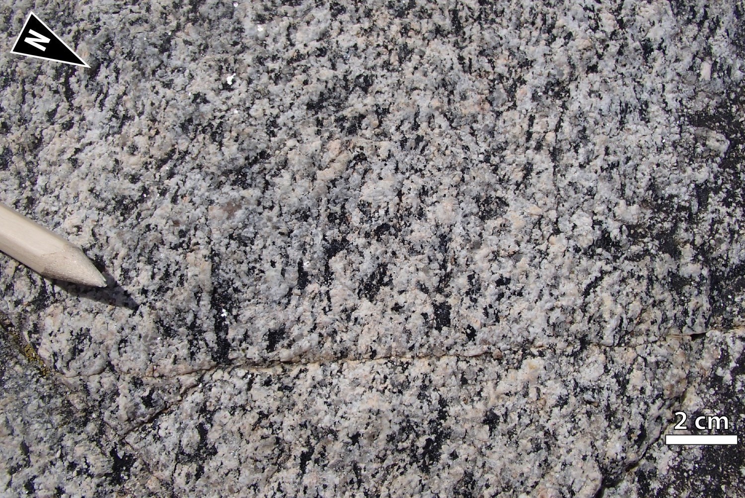
 The MacLeod Batholith forms a saucer-shaped intrusive complex emplaced in the Neoarchean. It is hosted in metasedimentary rocks of the Laguiche Complex and cuts adjacent intrusive units belonging to the Opatica Subprovince. The MacLeod Batholith is very homogeneous, medium grained and foliated. Its average composition consists of granodiorite and quartz monzodiorite, whose quartz percentage generally oscillates around 20%. Some compositional zonality is observed in the intrusion. At the edge of the batholith, the percentage of quartz in the rock is slightly higher than 20%, showing granodiorite. At the centre of the intrusion, a few outcrops rather show quartz-depleted monzodiorite (~5%). The rock is white-grey with black spots in altered surface and fresh exposure. Hornblende and biotite are observed throughout the intrusion. Hornblende is dominant in the centre and western portion of the intrusion, while biotite is more abundant in the Corne Lake area. Magnetite gives the rock a homogeneous magnetic signature ranging from moderate to strong. Ferromagnesian minerals form millimetric to centimetric clusters aligned in weakly to moderately developed Sn foliation planes.
In thin section, minerals observed are quartz, feldspars (plagioclase to K-feldspar rations of 2/1 to 3/1), hornblende and biotite. Accessory minerals are titanite (≤5%), epidote (pistachite, allanite), apatite, zircon and magnetite. Hornblende chloritization and plagioclase sericitization are commonly observed. The MacLeod Batholith is characterized by zoned alteration ranging from mild to intense. Potassic alteration (biotite, magnetite and K-feldspar in varying proportions) is present at the centre of the intrusion. Propylitic alteration (quartz, chlorite and epidote) and silicification are located at the edge of the intrusion. Later hematite and epidote-filled veinlets cut the Sn foliation and remobilize some of the Cu-Mo-Ag-Au-W mineralization hosted in the MacLeod Batholith and surrounding metasedimentary units.
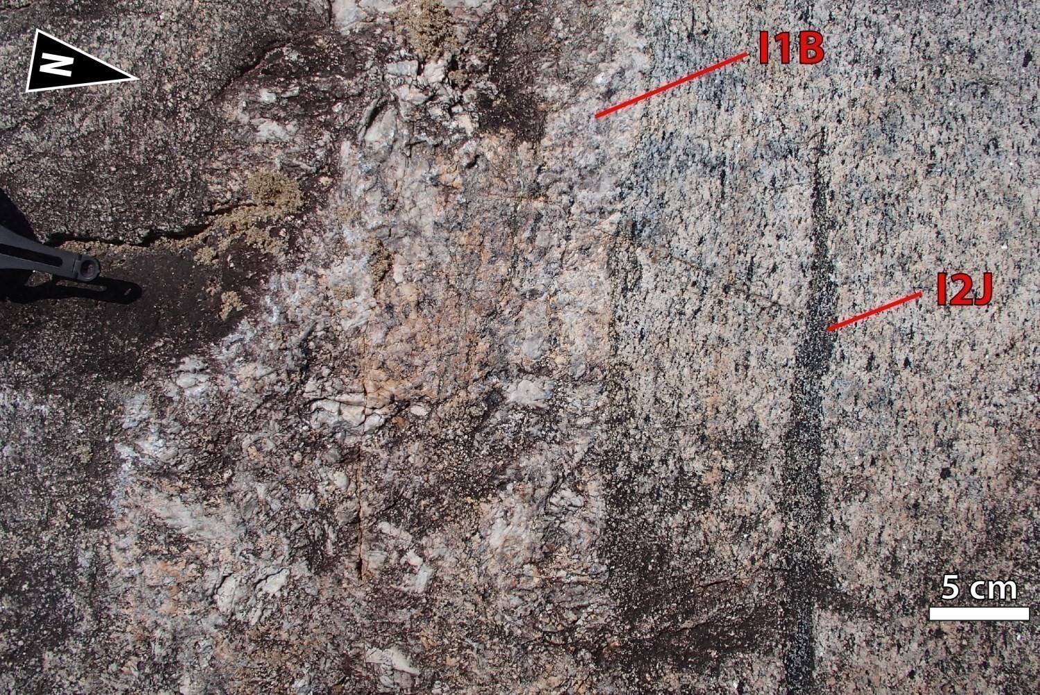
The MacLeod Batholith is sharply cut by hematitized granite, which could represent a later magmatic intrusion within the batholith. Granite is massive to weakly foliated and is composed of biotite-hornblende ± magnetite. Magnetite forms centimetric clusters. The presence of hornblende in the granite may be a result of enclave contamination. The MacLeod Batholith contains numerous enclaves of mesocratic diorite and granoblastic hornblende gabbro that show a well-developed mineral lineation.
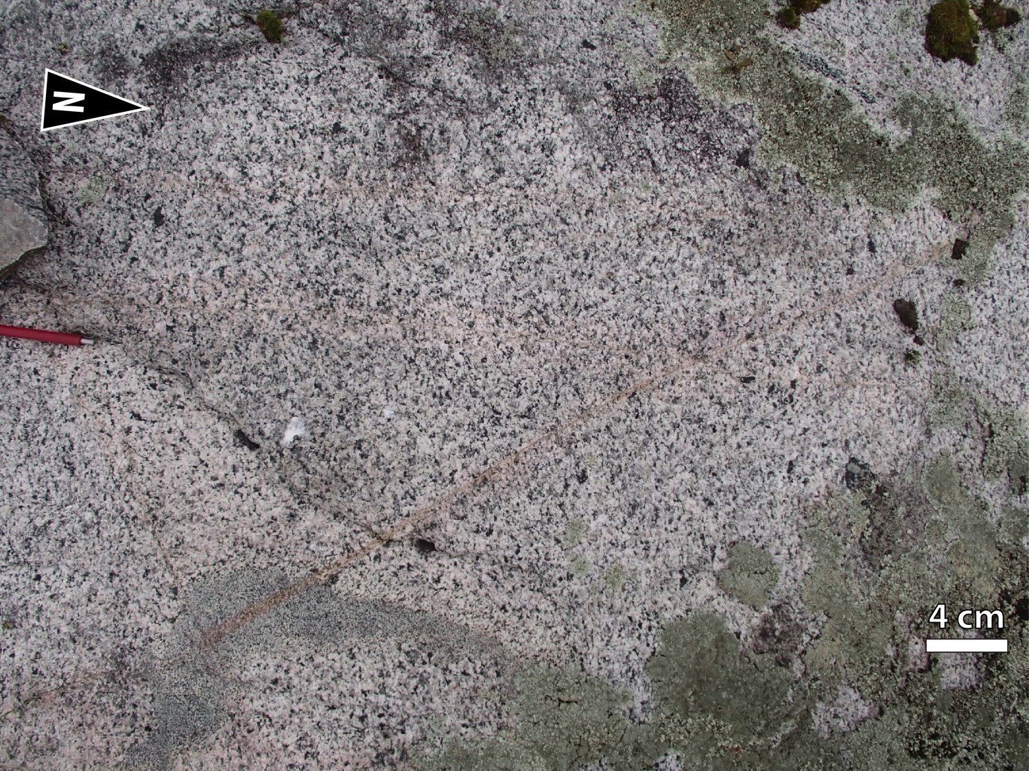
Type outcrop 18-LP-6149 consists of quartz monzodiorite and granodiorite. The rock is homogeneous and moderately foliated. The quartz content ranges from 18% to 25%. The sample collected contains 20% ferromagnesian minerals (predominantly hornblende ± biotite ± magnetite ± titanite) forming small lenticular millimetric aggregates parallel to the Sn foliation. The outcrop also contains small rounded diorite enclaves. Coarse-grained pinkish granite intrusions cut quartz monzodiorite.
Geochemical analyses of samples collected during the summer 2018 mapping work (Beauchamp, 2020) indicate that the MacLeod Batholith is a magnesian granitoid, generally calc-alkaline and type I (Maniar and Piccoli, 1989) metaluminous (Frost et al., 2001) . In the diagrams of Pearce et al. (1984), samples plot in the field of volcanic arc granites. The rare earth diagram normalized to CI chondrite (Palme and O’Neill, 2004) shows light rare earth enrichment over heavy rare earths. Negative anomalies in Nb, Ta, P and Ti, as well as positive anomalies in La, Ce and Nd characterize the spider diagram of this unit.
Thickness and Distribution
The MacLeod Batholith has a wavy shape caused by regional folding. The intrusive mass extends 25 km in an ENE-WSW direction and is 15 km thick. It covers an area of 205 km2. The MacLeod Batholith is located in the Cadieux Lake area (Sheets 33A02, 33A03 and 33A07) and is part of the Cadieux Structural Domain.
Dating
The magmatic crystallization age of the MacLeod Batholith is estimated at 2704 ±2 Ma (sample 18-FM-2088A). The Cu-Mo-Au-Ag-W mineralization in the MacLeod Batholith is therefore contemporary or younger than 2704 ±2 Ma.
| Unit | Sample Number | Isotopic System | Mineral | Crystallization Age (Ma) | (+) | (-) | Reference(s) |
| nAmcl | 18-FM-2088A | U-Pb | Zircon | 2704 | 2 | 2 | Davis, 2019 |
Stratigraphic Relationship(s)
 The MacLeod Batholith is younger than the Misasque Complex, Digne Pluton and Laguiche Complex, according to field relative chronology and available geochronological dating. Since it is affected by the Sn foliation, intrusion of the MacLeod Batholith would be later or synchronous with the Dn deformation.
The highly localized presence of porphyraceous granodiorite enclaves in the MacLeod Batholith appears to support the geochronology and confirm that intrusion of the MacLeod Batholith slightly predates crystallization of the Cadieux Suite. An episode of significant plutonism between 2699 Ma and 2705 Ma contributed to the emplacement of several intrusive masses in the Cadieux Lake and Bohier Island area. This period corresponds to the magmatic crystallization age of the tonalitic unit of the Mabille Complex (nAmbi1), the MacLeod Batholith and the Cadieux Suite.
Both macroscopically and microscopically, rocks of the MacLeod Batholith resemble those of the Lépante Suite. It is therefore possible that these two intrusive bodies are related and of similar ages.
Paleontology
Does not apply.
References
Publications Available Through Sigéom Examine
BEAUCHAMP, A.-M., 2020. Geology and Mineral Potential of the Cadieux Lake area, Opatica and Opinaca Subprovinces, Eeyou Istchee James Bay, Quebec, Canada. MERN. BG 2019-02, 2 plans.
DAVIS, D.W., 2019. Rapport sur les datations U-Pb de roches du Québec 2018-2019, projets Lac Cadieux et Lac Watts. UNIVERSITY OF TORONTO. MB 2019-09, 82 pages.
HOCQ, M., 1975. GEOLOGIE DE LA REGION DU LAC CAMPAN (NOUVEAU-QUEBEC). MRN. DP 331, 13 pages and 9 plans.
HOCQ, M., 1985. GEOLOGIE DE LA REGION DES LACS CAMPAN ET CADIEUX, TERRITOIRE-DU-NOUVEAU-QUEBEC. MRN. ET 83-05, 190 pages and 4 plans
MCAULEY, J.B., 1990. GEOLOGICAL REPORT ON THE MAIN ZONE AND SURROUNDING AREA, MACLEOD LAKE PROPERTY. WINDY MOUNTAIN EXPLS LTD. Assessment work submitted to the Government of Québec. GM 51329, 39 pages and 1 plan.
PRIOR, G.J., 1991. PRELIMINARY REPORT ON RECONNAISSANCE GEOLOGICAL MAPPING AND PROSPECTING, EASTMAIN RIVER PROJECT. WINDY MOUNTAIN EXPLS LTD, COCHISE RESOURCES INC. Assessment work submitted to the Government of Québec. GM 50827, 99 pages and 13 plans.
PRIOR, G.J., PILKEY, D., MCAULEY, J., CLEMENT, Y., 1991. REPORT ON PHASE FOUR DRILLING, MACLEOD LAKE PROPERTY. WINDY MOUNTAIN EXPLS LTD. Assessment work submitted to the Government of Québec. GM 51335, 228 pages and 17 plans.
WINTER, L.D.S., 2008. DRILLING PROGRAM REPORT, MACLEOD LAKE PROPERTY. WESTERN TROY CAPITAL RESOURCES. Assessment work submitted to the Government of Québec. GM 63812, 499 pages.
Other Publications
COOK, R.B., COX, J.J., PRESSACCO, R., SCOTT, K.C., 2008. Preliminary Assessment of the MacLeod Lake Project, Quebec, Canada, prepared for Western Troy Capital Resources Inc., NI43-101 Report, Scoot Wilson Roscoe Postle Associates Inc., 231 pages, 48 tableaux and 52 plans.
FROST, B.R., BARNES, C.G., COLLINS, W.J., ARCULUS, R.J., ELLIS, D.J., Frost, C.D., 2001. A geochemical classification for granitic rocks. Journal of Petrology; volume 12, number 11, pages 2033-2048. doi.org/10.1093/petrology/42.11.2033
MANIAR, P.D., PICCOLI, P.M., 1989. Tectonic discrimination of granitoids. Geological Society of America Bulletin; volume 101, pages 635-643.
MCDONOUGH, W.F., SUN, S.S., 1995. The composition of the earth. Chemical Geology; volume 120, pages 223-253. doi.org/10.1016/0009-2541(94)00140-4
PALME, H., O’NEILL, H.S.C. 2004., Cosmochemical estimates of mantle composition. In Treatise on Geochemistry. (Holland, H.D. and Turrekian, K.K. editors), Elsevier, Amsterdam, The Netherlands; volume 2, pages 1-38. doi.org/10.1016/B978-0-08-095975-7.00201-1
WINTER, L.D.S., 2011. Technical report NI 43–101 for the MacLeod Lake property, Chibougamau mining district, Quebec, preparé pour Western Troy Capital Resources Inc., NI43-101 Report, 74 pages.
Suggested Citation
Ministère de l’Énergie et des Ressources naturelles (MERN). MacLeod Batholith. Quebec Stratigraphic Lexicon. https://gq.mines.gouv.qc.ca/lexique-stratigraphique/province-du-superieur/batholite-de-macleod_en [accessed on Day Month Year].
Contributors
|
First publication |
Anne-Marie Beauchamp, Eng., M.Sc. anne-marie.beauchamp@mern.gouv.qc.ca (redaction) Mehdi A. Guemache, P. Geo., Ph.D. (coordination); Patrice Roy, P. Geo., M.Sc. (critical review); Simon Auclair, P. Geo., M.Sc. (editing); Céline Dupuis, P. Geo., Ph.D. (English version); Ricardo Escobar Moran (HTML editing). |

