

Last modified:
Translation of original French
| Author: | Cimon, 1977 |
| Age: | Neoarchean |
| Reference section: | The section described by Cimon (1977) was drawn from a series of local outcrops south of Audet and Pierre lakes. |
| Type area: | SE Queylus Township (sheet 32G09-200-0201) |
| Geological province: | Superior Province |
| Geological subdivision: | Abitibi Subprovince |
| Lithology: | Basalt, andesitic basalt |
| Type: | Lithostratigraphic |
| Rank: | Formation |
| Status: | Formal |
| Use: | Active |
- Roy Group
- Bordeleau Formation
- Ruisseau Dalime Formation
- Scorpion Formation
- Phooey Member
- Blondeau Formation
- Bruneau Formation
- Waconichi Formation
- Allard Member
- Scott Member
- Deux Orignaux Member
- Winchester Member
- Lemoine Member
- Portage Member
- Lacs Member
- Îles Member
- Coyote Member
- Chevrier Member
- Queylus Member
- Andy Member
- Obatogamau Formation
- Pichamobi Member
- Wachigabau Member
- David Member
Background
The Obatogamau Formation was established by Cimon (1977) in reference to the Obatogamau lakes located in NTS sheet 32G09. On the northern flank of the Chibougamau Anticline, basalt and andesitic basalt initially assigned to the lower portion of the Gilman Formation (Ludden et al., 1984; Daigneault and Allard, 1990) were grouped by Leclerc et al. (2008) in the David Member. However, by including the overlying Allard Member in the Waconichi Formation, the Gilman Formation was abandoned and the David Member was integrated into the Obatogamau Formation (Leclerc et al., 2011).
Description
The Obatogamau Formation represents the lower portion of the Roy Group's first volcanic cycle (Cimon, 1977; Daigneault and Allard, 1990). In the Queylus Township area (sheet 32G09), where it was originally recognized, the Obatogamau Formation consists of three informal basalt units (lower, median and upper) distinguishable by the percentage of plagioclase phenocrystals. Percentages range from 1% to 3% in the lower unit, typically reaching 20% in the median unit, and decreasing below 1% in the upper unit, which is generally aphyric. However, these divisions could not be generalized to the entire formation. The summit of the Obatogamau Formation also includes some rhyolite lenses and pyritic rhyolitic tuff. On the northern flank of the Chibougamau Anticline (sheet 32G16), the upper part of the Obatogamau Formation corresponds to the David Member (Leclerc et al., 2011). To the northwest of Chapais (sheets 32G14-200-0201 and 32J03-200-0101), the Obatogamau Formation contains a lens of felsic volcanic rocks attributed to the Pichamobi Member (Charbonneau et al., 1991).
Obatogamau Formation 1 (nAob1): Basalt and Andesitic Basalt

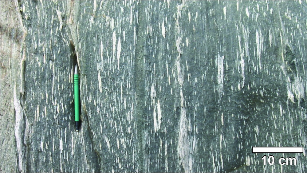
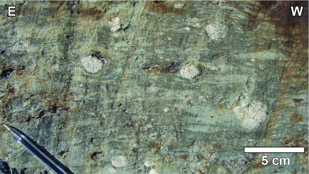
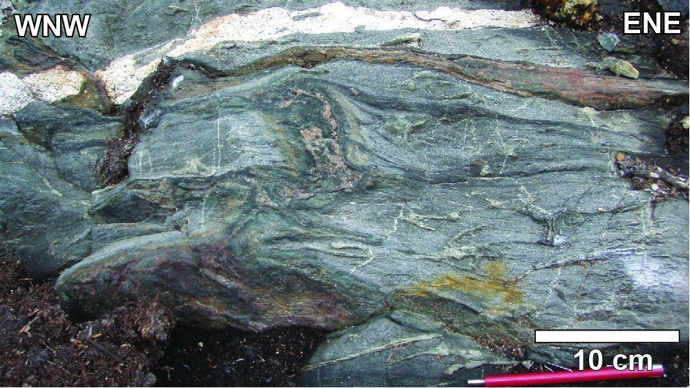
Massive, pillowed and brecciated basalts and andesitic basalts of the Obatogamau Formation are characterized by the common presence of plagioclase phenocrystals associated with the development of a glomerophyric texture. Massive and pillowed facies are the most common. The pillows' long axis ranges from 10 to 40 cm, but can reach more than one metre in deformation corridors. They may contain millimetric ovoid carbonate-chlorite amygdules. The brecciated facies is scarce and characterized by angular fragments ranging in size from 1 to 5 cm. The rock is uniformly green in fresh exposure with beige phenocrystal clusters (glomerorphyric texture) up to 3 cm in diameter. The rock has a dark green to orange-brown patina in shear zones dominated by chlorite and ankerite alteration, while it is rather light green to beige in areas of abundant silica and epidote. Silification is associated with intense fracturing and the increased presence of millimetric quartz veinlets. In all cases, alteration accentuates the contour of primary structures (pillow margins, flow breccia fragments). In the Kapunapotagen and Gwillim deformation corridors, mafic volcanic rocks are transformed into chlorite-sericite ± ankerite schist. Intense deformation and alteration have partially obliterated primary structures.
Obatogamau Formation 1a (nAob1a): Garnet-Pyroxene Amphibolite
Garnet-clinopyroxene amphibolites (unit Aob1a) located in the Lac Dufresne Deformation Zone, on the western edge of the La Dauversière Pluton, are the metamorphozed equivalent of massive, pillowed and brecciated mafic volcanic rocks of unit nAob1. Primary structures are still recognizable but are affected by deformation and by local migmatitization. Garnet-clinopyroxene amphibolite enclaves within the La Dauversière Pluton are fine to medium grained and banded with alternating bands rich in mafic minerals (hornblende, garnet and clinopyroxene) or in plagioclase (Roy et al., 2005).
Obatogamau Formation 2 (nAob2): Mafic to Intermediate Volcaniclastic Rock
Some volcaniclastic rock lenses of mafic to intermediate composition and calc-alkaline affinity are interbedded between basalt and andesitic basalt flows. The size of beige to grey angular fragments does not exceed 4 mm (fine-lapilli tuff).
Thickness and Distribution
The Obatogamau Formation's total thickness is estimated between 3 km to 4 km (Daigneault and Allard, 1990). Volcanic rocks of the Obatogamau Formation occupy the base of the stratigraphic pile in the area between Desmaraiville and Chibougamau (sheets 32G05-32G16, 32H13, 32J01-32J03), with the exception of localities where significantly older rocks are attributed to the Istotao Gneissic Complex (2831 ±5 Ma; Roffeis, in preparation), Vents Formation (2798.7 ±0.7 Ma; Davis et al., 2014) and Chrissie Formation (2791.4 +3.7/-2.9 Ma; David et al., 2011). According to Daigneault and Allard (1990), its setting environment corresponds to a submarine basalt plain.
Dating
None. The glomerorphyric texture and chemistry of mafic volcanic rocks of the Obatogamau Formation are very similar to those of anorthosites of the Lac Doré Intrusive Suite (2728.3 +1.2/-1.1 Ma and 2727.0 ±1.3 Ma; Mortensen, 1993), suggesting a similar source and contemporary emplacement (Daigneault and Allard, 1990).
Stratigraphic Relationship(s)
The Obatogamo Formation's basal contact corresponds to shear zones observed in the field or interpreted using aeromagnetic data. These shear zones mark a gap of some 60 Ma to 100 Ma between mafic volcanic rocks of the Obatogamau Formation, which are in stratigraphic continuity with overlying felsic units of the Waconichi Formation (2730-2726 Ma; Mortensen, 1993; Legault, 2003; Leclerc et al., 2011; David et al., 2012), and much older units of the Istotao Gneissic Complex (2831 ±5 Ma; Roffeis, in preparation), Vents Formation (2798.7 ±0.7 Ma; Davis et al., 2014) and Chrissie Formation (2791.4 +3.7/-2.9 Ma; David et al., 2011).
Paleontology
Does not apply.
References
| Author(s) | Title | Year of Publication | Hyperlink (EXAMINE or Other) |
|---|---|---|---|
| CHARBONNEAU, J.-M. – PICARD, C. – DUPUIS-HÉBERT, L. | Synthèse géologique de la région de Chapais-Branssat (Abitibi). Ministère de l’Énergie et des Ressources, Québec; MM 88-01, 200 pages, 13 plans. | 1991 | MM 88-01 |
| CIMON, J. | Quart sud-est du canton de Queylus. Ministère des Richesses naturelles du Québec; DPV-448, 33 pages, 1 plan. | 1977 | DPV 448 |
| DAIGNEAULT, R. – ALLARD, G.O. | Le Complexe du lac Doré et son environnement géologique (région de Chibougamau – Sous-province de l’Abitibi). Ministère de l’Énergie et des Ressources, Québec; MM 89-03, 275 pages. | 1990 | MM 89-03 |
| DAVID, J. – MCNICOLL, V. – SIMARD, M. – BANDYAYERA, D. – HAMMOUCHE, H. – GOUTIER, J. – PILOTE, P. – RHÉAUME, P. – LECLERC, F. – DION, C. |
Datations U-Pb effectuées dans les provinces du Supérieur et de Churchill en 2009-2010. Ministère des Ressources naturelles et de la Faune; RP 2011-02, 37 pages. |
2011 | RP 2011-02 |
| DAVID, J. – SIMARD, M. – BANDYAYERA, D. – GOUTIER, J. – HAMMOUCHE, H. – PILOTE, P. – LECLERC, F. – DION, C. | Datations U-Pb effectuées dans les provinces du Supérieur et de Churchill en 2010-2011. Ministère des Ressouces naturelles et de la Faune, Québec; RP 2012-01, 33 pages. | 2012 | RP 2012-01 |
| DAVIS, D.W. – SIMARD, M. – HAMMOUCHE, H. – BANDYAYERA, D. – GOUTIER, J. – PILOTE, P. – LECLERC, F. – DION, C. | Datations U-Pb effectuées dans les provinces du Supérieur et de Churchill en 2011-2012. Ministère des Ressources naturelles, Québec; RP 2014-05, 62 pages. | 2014 | RP 2014-05 |
| LECLERC, F. – BÉDARD, J.H. – HARRIS, L.B. – GOULET, N. – HOULE, P. – ROY, P. | Nouvelles subdivisions de la Formation de Gilman, Groupe de Roy, région de Chibougamau, Sous-province de l’Abitibi, Québec : résultats préliminaires. Geological Survey of Canada; Current Researches 2008-7, 20 pages. | 2008 | Source |
| LECLERC, F. – BÉDARD, J.H. – HARRIS, L.B. – MCNICOLL, V. – GOULET, N. – ROY, P. – HOULE, P. | Tholeiitic to calc-alkaline cyclic volcanism in the Roy Group, Chibougamau area, Abitibi Greenstone Belt - Revised stratigraphy and implications for VHMS exploration. Canadian Journal of Earth Sciences; volume 48, pages 661-694. | 2011 | Source |
| LEGAULT, M. | Environnement métallogénique du couloir de Fancamp avec emphase sur les gisements aurifères de Chevrier, région de Chibougamau, Québec. Université du Québec à Chiboutimi; doctoral thesis, 488 pages. | 2003 | Source |
| LUDDEN, J.N. – FRANCIS, D.M. – ALLARD, G.O. | The geochemistry and evolution of the volcanic rocks of the Chibougamau region of the Abitibi metavolcanic belt. In: Chibougamau : stratigraphy and mineralization (Guha, J. and Chown, E.H., editors). Canadian Institute of Mining and Metallurgy; volume 34, pages 20-34. | 1984 | - |
| MORTENSEN, J.K. | U-Pb geochronology of the eastern Abitibi subprovince. Part 1: Chibougamau – Matagami – Joutel region. Canadian Journal of Earth Sciences; volume 30, pages 11-28. | 1993 | Source |
| ROFFEIS, C. | Rapport final du contrat de géochronologie MERN. GEOTOP, rapport inédit soumis au Ministère de l’Énergie et des Ressources naturelles, Québec. | 2015 | MB 2019-06 |
| ROY, P. – TURCOTTE, S. – CADÉRON, S. – HOULE, P. – SHARMA, K.N.M. | Géologie de la région du lac Charron (32G/08 et 32G/09). Ministère des Ressources naturelles et de la Faune, Québec; RG 2005-02, 35 pages, 3 plans. | 2005 | RG 2005-02 |