Last modified:
Translation of original French
| Author: | Allard, 1976 |
| Age: | Neoarchean |
| Reference section: | Reference strippings of the Blackrock-Zone Armitage and Vanadium-Lac Doré deposits, both located on the southern flank of the Chibougamau Anticline |
| Type area: | Southeastern portion of NTS sheet 32G16 |
| Geological province: | Superior Province |
| Geological subdivision: | Abitibi Subprovince |
| Lithology: | Mafic to ultramafic intrusive rocks |
| Type: | Lithodemic |
| Rank: | Lithodeme |
| Status: | Informal |
| Use: | Active |
Background
The unit was originally named the “Staged Ultramafic Zone” by Allard and Caty (1969), then the “Layered Zone” by Allard (1976). It was first included in the “Layered Series” by Daigneault and Allard (1990); it is now an informal lithodeme of the Lac Doré Layered Unit (Leclerc et al., 2017).
Description
The following descriptions are reported from Daigneault and Allard (1990, pp. 61–72). These authors refer to P1, P2 and P3 subdivisions, as well as the layered zone’s A1 and A2 units. These subdivisions are informal as described at the stripping scale; therefore, they cannot appear on 1:20 000 or 1:50 000 maps:
“Zone P1 is at the base of the Lac Doré Layered Unit. It is between 30 and 90 m thick and its economic importance lies in the fact that it is the only one that contains economic vanadium contents. Its contact with the anorthositic zone of the Lower Unit is sharp and abrupt; coarse-grained anorthositic gabbros of the upper part of this unit contain centimetric layers rich in fine-grained magnetite. This magnetite, which is very rich in vanadium, is a precursor to that in zone P1. A sudden change in granularity and modal composition marks the beginning of P1: anorthosites with large, more or less spherical plagioclase are being replaced by well-layered rocks rich in ferropyroxenes and/or magnetite, where plagioclase occurs in 2-3-mm-long and 1-2 mm-thick tablets. Parallelism between ferropyroxene and plagioclase produces a characteristic primary magmatic foliation.
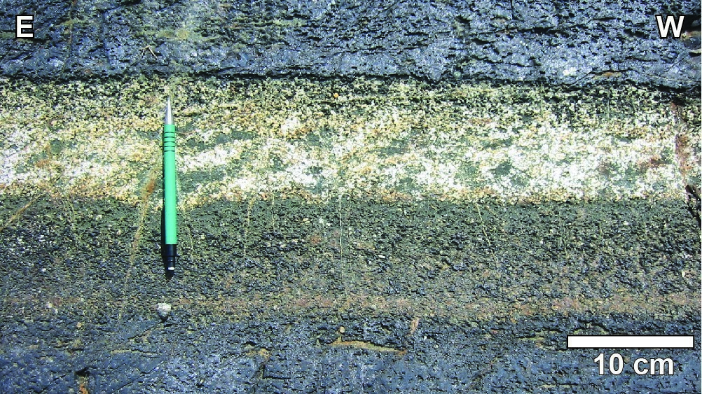
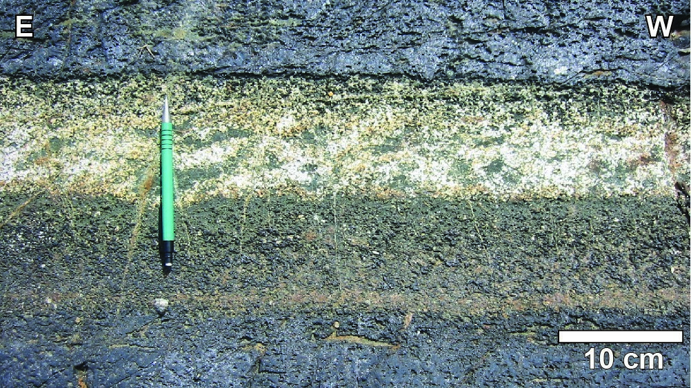
Zone P1 consists of layers of leucocratic ferrogabbro, magnetite ferrogabbro, ferropyroxenite, magnetite ferropyroxenite and magnetitite. Within a trench in the Rinfret Township, there were 289 different layers, many of which could still be further subdivided. Contacts between layers vary from sharp on both sides to sharp on one side, to gradual on one side and/or the other, and to sharp on one side but gradual on the other. Two gradual contacts produce a magnetite-rich horizon in the centre of a layer. Gabbroic layers are greenish yellow, caused by ferriferous epidote, which contrasts with white clinozoisite of anorthosites (iron poor). Magnetitite beds are black and ferropyroxenite layers range from dark green when rich in ferrochlorite and ferropargasite, to lighter green when rich in ferroactinolite. On polished glacial surface, the cumulate texture is perfectly preserved despite intense mineralogical transformations undergone by these rocks. […]
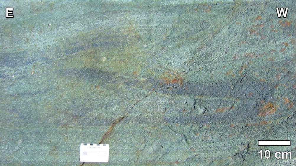
Zone A1 consists of gabbroic anorthosite very similar to that of the Lac Doré Lower Unit. It is 6 to 45 m thick. In some places, there are signs of bedding and poikilitic texture. [… ] The upper contact of zone A1 is unique. The very irregular surface of the latter contrasts with the very continuous and regular beds of magnetitite and gabbro in zones P1, P2 or P3. This type of contact is typical of all anorthositic passages not forming specific zones within the Lac Doré Layered Unit. The granulometry and morphology of cumulus plagioclases in this zone probably contributes greatly to this irregular and undulatory surface. Magmatic sedimentation and the overlying zone (P2) caused settling of plagioclase and magnetite grains much smaller and more regular than those of zone A1. The first layers of zone P2 thus tend to fill irregularities on the surface of zone A1, and the following layers tend to be deposited in a regular and straight-lined manner over lengths of several metres. Where the zone A1 surface was found to be too irregular, magnetitite beds of zone P2 area were deposited on unstable slopes, resulting in sliding folds. These observations suggest normal gravitational magmatic sedimentation for the Lac Doré Layered Unit. It would be difficult to explain these phenomena by crystallization in situ or by convection carrying grains parallel to the crystallization surface.
Zone P2 is 9 to 60 m thick and closely resembles zone P1 except that vanadium contents are lower. It has the same lithologies and sedimentary characteristics. Its contact with zone A1 is very irregular, as has just been described. Ferrogabbro and magnetitite predominate in its lower part while ferropyroxenite and magnetitite mark its upper part. […]
Zone A2 consists of rocks that closely resemble those of Zone A1. They consist of gabbroic anorthosites and anorthositic gabbros containing small amounts of interstitial quartz. This zone ranges from a few metres to 450 m, but this latter value is probably exaggerated and can be explained by repetition along the directional fault that passes through Laugon Lake (Rinfret Township). Cumulus plagioclase crystals are coarse-grained and more or less round. They are replaced by albite and clinozoisite-epidote. Actinolite and chlorite replace pyroxene. Some sphene and quartz grains are found in intercumulus position.
Zone P3 is much thicker than zones P1 and P2 (180 to 360 m), but the lack of drillings limits its knowledge. It consists of dark green ferropyroxenite interbedded with thin layers of ferrogabbro. Grain size is smaller than in zones P1 and P2; however, some irregular layers of anorthositic gabbro near the base of the zone have the coarse-grained texture common to these rocks. As in other zones of the Lac Doré Layered Unit, rhythmic magmatic bedding is ubiquitous. Zone P3 includes a bottle-green ilmenite-ferrosilicate subzone ranging in thickness from 60 to 240 m. Ferropyroxenite is there interbedded with thin layers of ferrogabbro, and magmatic bedding is preserved and very regular. There are far fewer fragments than in ferropyroxenite of the Lower Unit and in the lower part of the Layered Unit. Ilmenite content ranges from 5 to 15%. The ilmenite-apatite subzone is very similar to the previous one, except that it contains up to 15% apatite. This apatite is associated with ilmenite in intercumulus position and occurs as relatively euhedral crystals, milky white due to their alteration. The ilmenite-apatite subzone is approximately the same thickness as the previous subzone. It is recognized by the presence of a grey mushroom (Fungus) beneath the moss covering the outcrop. This plant species appears to be growing at high phosphorus contents in the rock. The quartz subzone is the summit of zone P3. The amount of granophyric quartz grains increases rapidly as moving up the unit. A fine example of this subzone is found on the Armitage Lake road, 300 m from the intersection with the Vanadium-Lac Doré deposit road. Ferropyroxenite becomes grey with purple shades and the quartz content increases rapidly. Bedding is becoming increasingly difficult to recognize and, in two or three metres, the rock changes to sodic granophyry of the Upper Unit. In other places, this transition is gradual on a decametric scale.”
Thickness and Distribution
The layered zone was identified as discontinuous klippes on the northern flank of the Chibougamau Anticline. On the southern flank of the same anticline, the layered zone outcrops for a distance of approximately 30 km. The layered zone thickness varies between 100 and 450 m (Allard, 1976; Daigneault and Allard, 1990).
Dating
A quartz pyroxenite sample from the layered zone yielded an age of 2728.3 +1.2/-1.1 Ma (Mortensen, 1993).
| Isotopic System | Mineral | Crystallization Age (Ma) | (+) | (-) | Reference(s) |
| U-Pb | Zircon | 2728.3 | 1.2 | 1.1 | Mortensen, 1993 |
Stratigraphic Relationship(s)
Rocks of the Lac Doré layered zone are found at the top of the anorthositic zone (Lac Doré Lower Unit), but at the base of the granophyric zone (Lac Doré Upper Unit).
Paleontology
Does not apply.
References
| Author(s) | Title | Year of Publication | Hyperlink (EXAMINE or Other) |
|---|---|---|---|
| ALLARD, G.O. | Doré Lake Complex and its importance to Chibougamau geology and metallogeny. Ministère des Richesses naturelles, Québec; DPV 368, 486 pages, 2 plans. | 1976 | DPV 368 |
| ALLARD, G.-O. – CATY, J.-L. | Géologie du Quart nord-est et d’une partie du Quart sud-est du canton de Lemoine, comtés d’Abitibi-Est et de Roberval. Ministère des Richesses naturelles, Québec; RP 566, 25 pages, 1 plan. | 1969 | RP 566 |
| DAIGNEAULT, R. – ALLARD, G.O. | Le Complexe du lac Doré et son environnement géologique (région de Chibougamau – Sous-province de l’Abitibi). Ministère de l’Énergie et des Ressources, Québec; MM 89-03, 290 pages. | 1990 | MM 89-03 |
| LECLERC, F. – ROY, P. – HOULE, P. – PILOTE, P. – BÉDARD, J.H. – HARRIS, L.B. – McNICOLL, V.J., VAN BREEMEN, O. – DAVID, J. – GOULET, N. | Géologie de la région de Chibougamau. Ministère de l’Énergie et des Ressources naturelles, Québec; RG 2015-03, 97 pages, 6 plans. | 2017 | RG 2015-03 |
| MORTENSEN, J.K. | U-Pb geochronology of the eastern Abitibi subprovince. Part 1: Chibougamau – Matagami – Joutel region. Canadian Journal of Earth Sciences; volume 30, pages 11–28. | 1993 | Source |


