

Last modified: 17 May 2023
Translation of original French
| Author(s): | Harrison, 1952 |
| Age: | Paleoproterozoic |
| Reference sectionStratotype: | None |
| Type area: | Menihek and Howell lakes, Newfoundland and Labrador (NTS sheet 23J07) |
| Geological province: | Churchill Province |
| Geological subdivision: | New Quebec Orogen (Labrador Trough) / Bérard, Hurst, Mélèzes, Payne, Schefferville and Tamarack lithotectonic zones |
| Lithology: | Clastic sedimentary rocks and, in lesser proportions, chemical or volcanic sedimentary rocks |
| Type: | Lithostratigraphic |
| Rank: | Formation |
| Status: | Formal |
| Use: | Active |
Background
The name Menihek Slates was first proposed by geologists at the Labrador Mining and Exploration Company in 1949 (Frarey and Duffel, 1964). The name Menihek Formation became formal with Harrison (1952).The formal name Menihek Formation was then introduced by Harrison (1952) in reference to the Menihek Lakes (NTS sheet 23J07) on the Newfoundland and Labrador side. Several works describing the Menihek Formation took place in the New Quebec Orogen (Labrador Trough). In the northern part of the orogen, north of latitude 56° 50′ N,the Menihek Formation was primarily described by DresslerBérard (1957a-b, 1959, 1965), in the areas of the Garigue (sheet 24L01), Bérard (sheet 24L08) and Feuilles (sheets 24K13 and 24L16) lakes, by Dressler (1973, 1975, and 1979) and Ciesielki (1975) in the Caniapiscau River area between the northern part of Lake Cambrien (sheet 24C11) and Lake Minguarutittalik (sheet 24F03)in the Patu Lake area and around Fort Mackenzie, and by Clark (1977, 1979 and 1984) in the Forbes Lake (sheet 24F05), and Napier Lake (sheets 24E06, 24E16, 24F12 and 24F13) and Cambrien Lake (24C06) areas. In the northern end of the Labrador Trough, rocks of the Menihek Formation have been described by Bergeron (1957) in the Brochant River area (sheets 24N12 and 24N13), by Freedman and Philpotts (1958) as well as Gold (1962) in the area west of Aupaluk (sheets 24M01, 24M08 and 24N05), by Hardy (1976) in the Roberts Lake and Des Chefs Lake area, north of Kangirsuk (sheets 25C04, 25D01 and 25D08) and by Madore and Larbi (2000) in the Arnaud River area (sheets 25C and 25D). In the southern part of the orogen, south of latitude 56° 50′ N, Menihek Formation rocks have been mapped in Quebec by Dimroth (1965, 1970 and 1978), Baragar (1967), Frarey (1967) and Zajac (1974), and in Newfoundland and Labrador by Frarey (1961), Evans (1978) and Wardle (1979 and 1982). The Menihek Formation has also been mapped as part of the Ministère’s compilation work (MRNF, 2010a-l; Bilodeau et al., 2011, 2012a-c; Lafrance et al., 2012; Clark, 2019).In the summer of 2017, it was the subject of a geological revision by Bilodeau and Caron-Côté (2018) in the northern end of the Labrador Trough.
Hardy (1976) mapped the Menihek Formation rocks in the Roberts and Des Chefs lakes area, north of the village of Kangirsuk, in the Labrador Trough’s northern end. Rocks of the Menihek Formation in the southern part of the orogen were mapped in Quebec by Baragar (1967), Fahrig (1967) and Dimroth (1978), and on the Newfoundland and Labrador side by Frarey (1961), Evans (1978) and Wardle (1979, 1982).
In the northern part of the orogen, Bergeron (1954, 1956) proposed the name Larch River Formation (now abandoned)for a sandstone, siltstone and mudstone sequence along the Mélèzes River(formerly the Larch River) (sheets 24E09 and 24F12). The name Larch River Formation had previously been given to these rocks by Fenimore Iron Mines geologists. In mapping the area straddling the Mélèzes River, Bérard (1965) identified the unit as the Formation de Rivière Larch River Formation. Sauvé and Bergeron (1965) used the same name for the unit west of Gerido and Léopard lakes (sheets 24F13 and 24K04). Clark and Wares (2004) recommended abandoning the name Larch River Formation as they consider the unit to be partially equivalent to the seniorUpper Baby mMember of the (Baby Formation) and the Menihek Formation.
The name Dragon Formation (now abandoned) was proposed by Bérard (1965) for a series of detrital sediments (rhythmites) located between the Sokoman Formation (known as the Fenimore Formation by Bérard, 1965, now abandoned) and the structurally overlying Chioak Formation in the northern part of the Labrador Trough. The unit consists of thin, greenish grey siltstone beds alternating with thin, black shale beds. These have lithostratigraphic similarities with black shale at or near the base of the Menihek Formation in the Schefferville area (Clark et al., 2008), the apparent base black shale of the Menihek Formation at the Mélèzes River (latitude 57°35′ N) and black shale of the Dragon Formation in the northern Labrador Trough. The unit was considered a sandstonean argillaceous sandstone member of the Menihek Formation by Clark and Wares (2004), and these authors recommended abandoning the name Dragon Formation.
Description
The Menihek Formation is the transgressive sequence’s upper unit of platform sediments belonging to the Ferriman Group, which deposited in the foreshore of the New Quebec Orogen during the second cycle of sedimentation and volcanism (Clark and Wares, 2004). The Menihek FormationIt consists primarily of rhythmites (turbidites) that are indicative of a deep-water deposit. These detrital sedimentary rocks consist of sandstone, siltstone, mudstone, graphitic mudstone (locally pyritic), grauwackephyllite, wacke, arenite (units pPme1, pPme2, pPme3 and pPme8) and, in smaller proportions, quartz-biotite-muscovite-chlorite±–garnet schist (unit pPme5), dolomite (unit pPme4), phyllite, conglomerate (unit pPme10) and iron formations (unit pPme9). Mafic volcanic activity began near the end of the Menihek Formation deposit, mainly in the allochtonous Hurst Zone (Baragar, 1967; Clark and Wares, 2004) in the southern orogen. Volcanic rocks consist of massive and pillow tholeitic basaltic flows (unit pPme6) with a small proportion of mafic pyrovolcaniclastic rocks (unit pPme7) (Baragar, 1967; Dimroth, 1978).
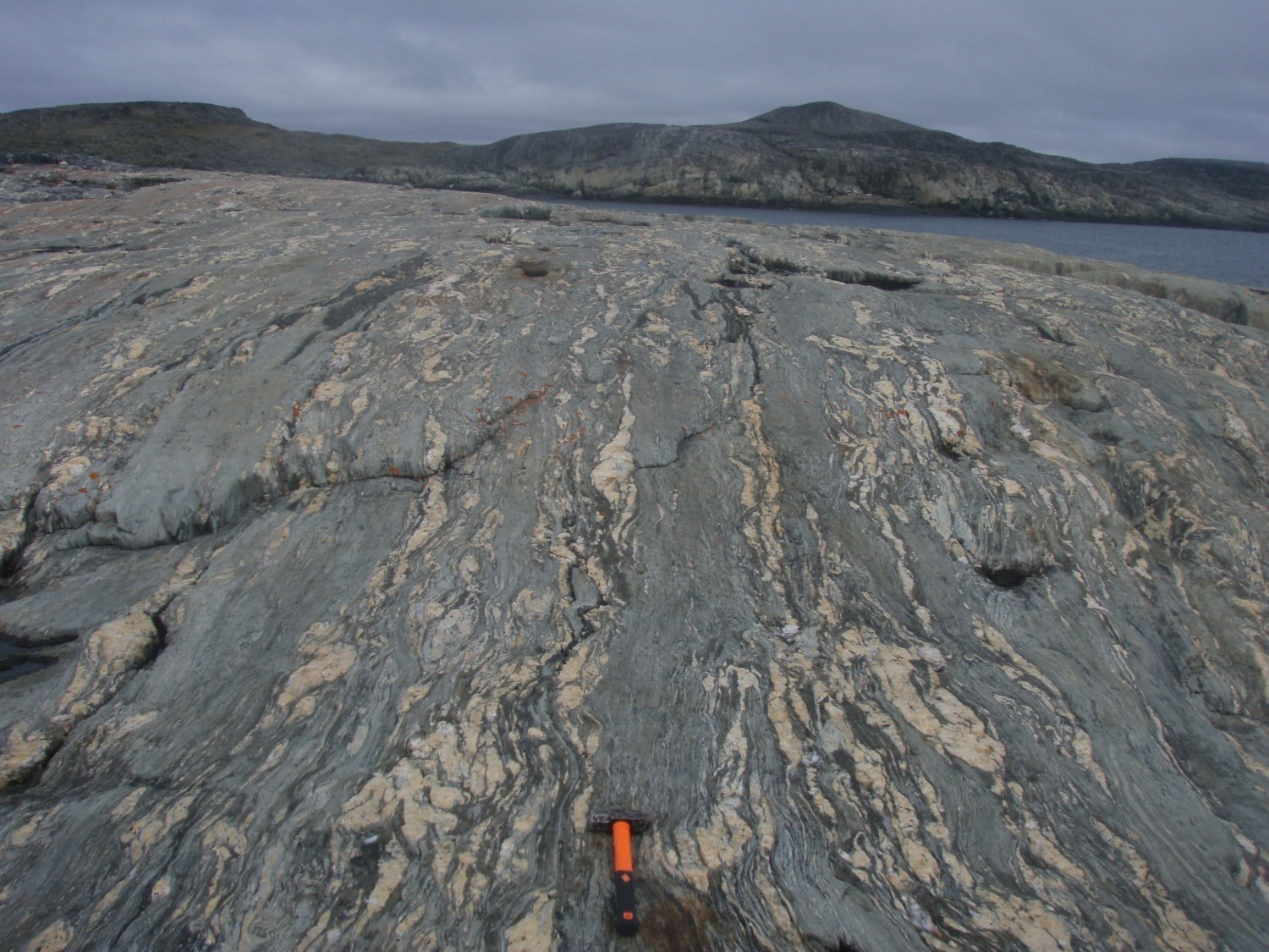
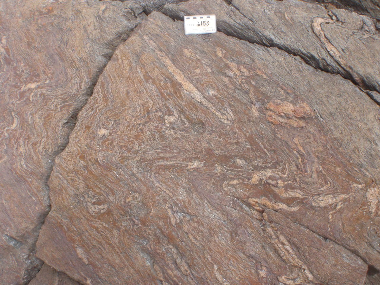
Rocks of the formation are usually metamorphosed to the greenschist facies. However, metamorphic facies range from greenschist to amphibolite in the northern end of the Labrador Trough‘s northern end, north of Aupaluk. On the western flank of the Roberts Synclinale as well as on the north side of the eponymous llake of the same name, mineralogical assemblages are representative of the greenschist facies. On the eastern flank of the Roberts Synclineal and in the Brochant River area south of the Arnaud River, they are instead representative of the amphibolite facies, evidenced by the Menihek 5schist unit (pPme5) (Bilodeau and Caron-Côté, 2018). Primary structures, such as cross-bedding, are common in the northern part of the Labrador Trough (Dimroth, 1978; Clark, 1979; ; Dressler, 1979), but are very local in the north end (Hardy, 1976). However, primary structures generally appear to be obliterated by tectonometamorphic secondary structures, such as schsiistosity and banding, generated during the building of the New Quebec Orogen (Bilodeau and Caron-Côté, in preparation).
The Menihek Formation is prospective for polymetalic mineralization of exhalative massive sulphides in graphic and pyritic mudstones (Clark and Wares, 2004). The Menihek Formation is prospective for polymetallic volcanogenic massive sulphide mineralization in graphitic and pyritic mudstones (Clark and Wares, 2004).
Unsubdivided Menihek Formation (pPme):Locally Pyritic Mudstone, Siltstone and Sandstone (Turbidites and Rhythmites); Minor Proportions of Conglomerate, Micaceous Schist, Dolomite, Quartzite and, Locally, Mafic Volcanic Rocks
This unsubdivided unit is composed of various Menihek Formation lithologies. In the south-central part of the Labrador Trough (sheet 23O01), these rocks consist mainly of a sequence of rhythmites formed of locally pyritic black mudstone, grey siltstone and sandstone (turbidites) (Dimroth, 1978; Wardle, 1982).They include a minor proportion of conglomerate, micaceous schist, dolomite and quartzite (‘quartz sandstone’ according to Dimroth, 1978) (Frarey, 1967; Wardle, 1982).In places, these sedimentary rocks may include mafic volcanic rocks: mafic flows, tuffaceous rocks, flow breccia (Frarey, 1967).In the central part of the Labrador Trough, in the area east of Canichico Lake (sheet 24C10), the unit consists mainly of a sequence of sandstone, siltstone and mudstone (Dressler, 1979).Further north, in the Feuilles Lake area (sheets 24K13 and 24L16), the rocks in this unit consist mainly of micaceous schist with a lesser proportion of dolomite and quartzite (Bérard, 1965).
Menihek Formation 1 (pPme1): Wacke, Siltstone and Phyllite ± AreniteMudstone, Siltstone and Phyllite; Minor Proportion of Wacke
The pPme1 unit overlies the Sokoman Formation.It consists mainly of mudstone, siltstone and phyllite, with a minor proportion of wacke (Baragar, 1967; Dimroth, 1978; Clark, 1977, 1979; Dressler, 1979).These different lithologies are generally interbedded and show a rhythmic structure (turbidites) (Clark, 1979).The mudstone and phyllite are dark grey to black and very fine-grained to aphanitic.Siltstone is grey, greenish grey or dark grey, very fine-grained and commonly fissile.These rocks are usually laminated and form beds millimetric to centimetric in thickness, locally reaching >1m.In places, they are slightly graphitic and pyritic (Clark, 1977, 1979; Dimroth, 1978).
The wacke is generally paler in colour than the siltstone and is typically fine-grained and massive (Clark, 1979).It is interbedded in mudstone and siltstone and is 0.1 to 2 m thick, and locally up to 6 to 8 m (Sauvé and Bergeron, 1965; Clark, 1979).The rock consists of angular grains (0.1 to 0.5 mm) of quartz, feldspar, muscovite, sphene and chert, along with a few fragments of volcanic and sedimentary rock.The matrix is composed of chlorite, sericite, epidote, carbonate and pyrite (Sauvé and Bergeron, 1965).In the area south of Bérard Lake (sheets 24L01 and 24L08), the rock locally contains stilpnomelane (Bérard, 1965).
Sedimentary structures most commonly observed in the upper part of wacke beds include contortions, sliding, sorting, erosion channels, cross bedding and load prints (Clark, 1977, 1979). Carbonate concretions (a few centimetres to 0.6 m in diameter) are common locally (Sauvé and Bergeron, 1965; Clark, 1977; Dimroth, 1978).
Menihek Formation 1a (pPme1a): Schistose Wacke; Minor Proportion of Schistose Siltstone, Phyllite and Arenite
This unit overlies the Sokoman Formation. In the Trough’s northern end of the Labrador Through (sheets 24M NE, 24N NW and 25D SE), unit pPme1 rocks are generally more schistose.itThey consists mainly of wacke and, in smaller proportions, siltstone, phyllite and arenite (Bilodeau and Caron-Côté, 2018).
Further south, the unit is described as alternating millimetric to centimetric bands of mudstone and grey to black siltstone, finely laminated, slightly graphitic and pyritic in places (Baragar, 1967; Dimroth, 1978; Dressler, 1979).
 Wacke has a brown or beige alteration patina and is light to dark medium grey in fresh exposure (Bilodeau et Caron-Côté, 2018). It is fine grained and generally schistose.The wacke commonly displays discontinuous millimetric quartz laminae.Schistosity planes are marked by the orientation of mica.The rock is commonly deformed and exhibits isoclinal folds and crenulation cleavages.Outcrops usually have millimetric to decimetric veinlets and veins, boudinaged and folded, composed of medium-grained quartz. Wacke is composed of quartz, muscovite, biotite and locally plagioclase. Minor and accessory mineral phases are plagioclase, carbonate, chlorite and pyrite.
The rock is fine grained. It is generally schistose and usually contains discontinuous millimetric quartz laminae. Schistosity planes are marked by the orientation of mica. The rock is usually deformed and exhibits isoclinal folds and crenulation cleavages (Bilodeau and Caron-Côté, 2018).
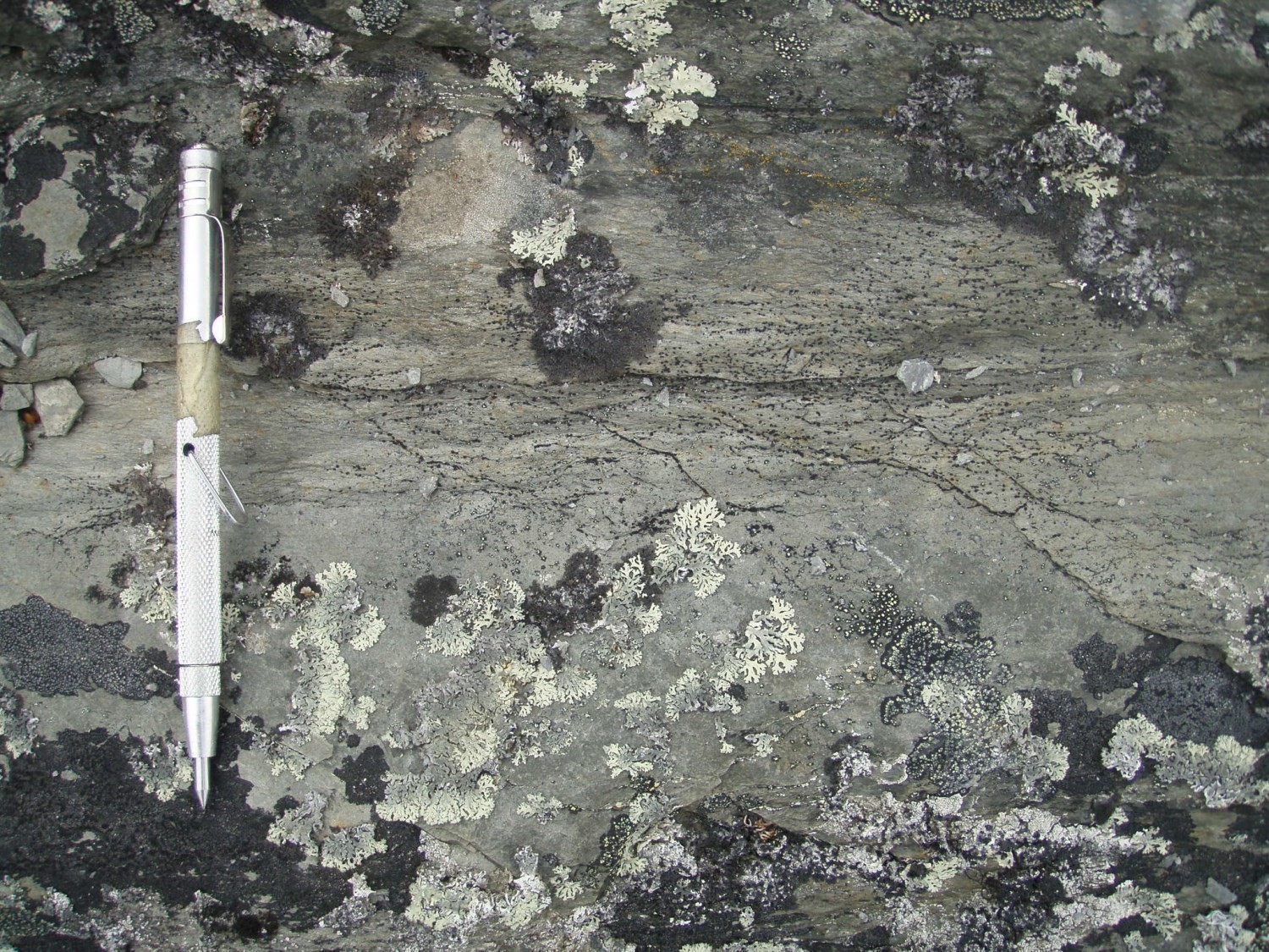
Siltstone has a medium brown to dark grey and locally rusty patina.has a moderately dark brown to blackish-grey alteration patina, locally rusty, and a dark blackish-grey fresh surface (Bilodeau and Caron-Côté, 2018). It is dark grey to blackish in fresh exposure. It is very fine grained to aphanitic and is usually laminated or schistose. This rock is mainly composed of biotite, muscovite and quartz. Minor and accessory mineral phases are generally graphite and sulphides (Bilodeau and Caron-Côté, 2018).
Phyllite is a metasiltstone or metamudstone with more penetrative schistosity(Bilodeau and Caron-Côté, 2018). In macroscopic samples, the surface of schistosity planes has a glossy appearance, likely caused by the sericite content. Phyllite has the same mineralogical composition as siltstone, but appears to be distinguished locally by a higher graphite content, ranging from (1 to 5%). Within the Roberts Synclinale, phyllite occursutcrops locally in different stratigraphic levels of the Menihek Formation. However, it is observed atin several locations in direct contact with the underlying unit of the Sokoman Formation (Bilodeau and Caron-Côté, 2018).
 Arenite is light to dark grey in fresh exposure and altered surface.It is fine to medium grained and generally has a massive, more locally laminated or schistose texture (Bilodeau aand Caron-Côté, 2018).Cross-beds werehave been observed locally (Hardy, 1976).The majority of areniterock is mainly composed of quartz and contains accessory minerals such as plagioclase, biotite, muscovite, epidote, K-feldspar, carbonate and magnetite. Arenitesic rocks observed in the Hardy (1976) and Bilodeau and Caron-Côté (2018) work are found mainly in the northern part of the Roberts Synclinale, north of the eponymous lake (intersection of sheets 25D07 to 25D10) of the same name. They are also found more locally along the eastern contact of the synclineal contact.
Menihek Formation 2 (pPme2): Grauwacke, Quartz Wacke, Sandstone, Quartz Sandstone and Siltstone and Mudstone BedsWacke, Quartz Wacke, Sandstone, Quartz Sandstone; Interbedded Siltstone and Mudstone
This unitUnit pPme2 formis the upper part of the Menihek Formation in the Labrador Trough’s northern partcentral-northern and southern parts of the Labrador Trough(sheets 23J NE, 23O, 24C, 24F NW, 24E NE and 24L SE). It consists mainly of centimetric to metric beds of grauwacke, quartz wacke, sandstone and quartz sandstone interstratified with millimetric to centimetric beds of siltstone and mudstone(Baragar, 1967; Dimroth, 1978; Clark, 1979; Dressler, 1979).Wacke and quartz wacke are grey, greenish grey or green and locally have a grey to yellowish-brown alteration patina. They are fine grained and are usually laminated or massive. These rocks routinely show millimetre-scale laminations, although outcrops located to the NW of Hématite Lake (sheet 24C10) rarely show evidence of stratification (Dressler, 1979).In the Otelnuk Lake area (sheet 24C01), Dimroth (1978) points out that stratifications, invisible in outcrop, can be observed under the microscope.In thin sections, wacke and quartz wacke show angular fragments (0.01 to 0.20 mm) of quartz, plagioclase and microcline in a matrix of green to light green-brown chlorite, minor proportions of sericite and iron oxides, and traces of carbonate.Biotite and opaque minerals are sometimes observed in places (Dressler 1979).
Sandstone and quartz sandstone hasve a chocolate brown, greenish grey or grey patina (Clark, 1979). It isThey are fine to very fine grained and is locally fissile (Clark, 1979). In thin section, sandstone and quartz sandstone isare composed of angular to saubangular grains (0.03 to 0.30 mm) of quartz, microcline and plagioclase, as well as minor amountsproportions of carbonate and small fragments of highly altered pyroxene (Dressler, 1979). The matrix is composed of chlorite, some sericite and very fine hematite dust. The latter gives the rock a chocolate-brown colour (Dressler, 1979).
GrauwWacke, quartz wacke and sandstone usually show cross-bedding, convolute bedding and carbonate (dolomitic) concretions (Clark, 1979; Dimroth, 1978; Dressler, 1979). Dolomitic concretions range in size from a few centimetres to 0.6 m (Clark, 1977).
Siltstone has a brown chocolate, green, grey-green or grey alteration patina (Clark, 1979; Dressler, 1979). It is very fine grained, laminated, and sometimeslocally fissile (Clark, 1979; Dressler, 1979). Mudstone has a reddish-brown alteration patina and is fissile (Clark, 1979). According to Clark (1979), the reddish colour of some beds may be associated with alteration because it cuts bedding. In some places, rare beds of grey chert, very coarse-grained sandstone and conglomerate with siltstone, quartz sandstone and microconglomerate and quartz sandstone pebbles are also reported (Clark, 1979, 1984; Dressler, 1979).
Menihek Formation 3 (pPme3): Quartz Sandstone, Subarkosic Sandstone, Wacke and Wacke; Locally Interbedded Chert-Pebble Conglomerate Beds
This unit consists of quartz sandstone, subarkosic sandstone and fine to medium-grained wacke with a medium grey, dark grey or black wackealteration patina (Clark, 1977). In the Forbes Lake area (sheet 24F05), the unit is located primarily at the base of the Menihek Formation and is estimated to be more than 100 m thick. Rocks are massive or locally show pit locally cross-bedding. Channels are also observed in places. Conglomerate beds 0.01 to 1 m thick are interstratifed locally in the unit. Conglomerate is commonly composed of grey chert pebbles, but white quartzite pebbles and rare jasper pebbles are also present(Ciesielski, 1975; Clark, 1977). The pebbles are subrounded to elongated and subangular to well rounded and are contained in a quartz sandstone matrix (Clark, 1977).
Menihek Formation 4 (pPme4): Dolomite and Sandy Dolomite
This unit consists of dolomite, sandy dolomite or dolomitic sandstone. However, it is not widespread. It is located on the Mélèze River’s north side (sheet 24E09), where it occurs as 2 to 3 m thick grey dolomite beds and 30 to 60 cm laminated sandy dolomite beds, interstratified with centimetre-thick mudstone fissile beds (Clark, 1979). In the Kyak Bay area, northSW of MargeryRoberts Lake (sheet 25D08), small dolomite outcrops is present inside the pPme1 unit in small outcrops rarely more than 15 m long by 3 m wide (Hardy, 1976) are found locally inside subunit pPme1a (Hardy, 1976). The rock is beige to brown in altered surface and light grey in fresh exposure. It is cut by many quartz veins, giving it a crosshatched appearance (Dimroth et al., 1970; Hardy, 1976). The most important veins are parallel to regional schistosity, while other veins are perpendicular to the first. The rock is composed of 87 to 97% dolomite with minor amounts of quartz (1-7%), biotite (up to ≤3%) and tremolite (up to ≤1%). Traces of talc and opaque minerals are also present (Hardy, 1976).
Menihek Formation 5 (pPme5): Quartz-Biotite-Muscovite-Chlorite ± Garnet Schist and Phyllite
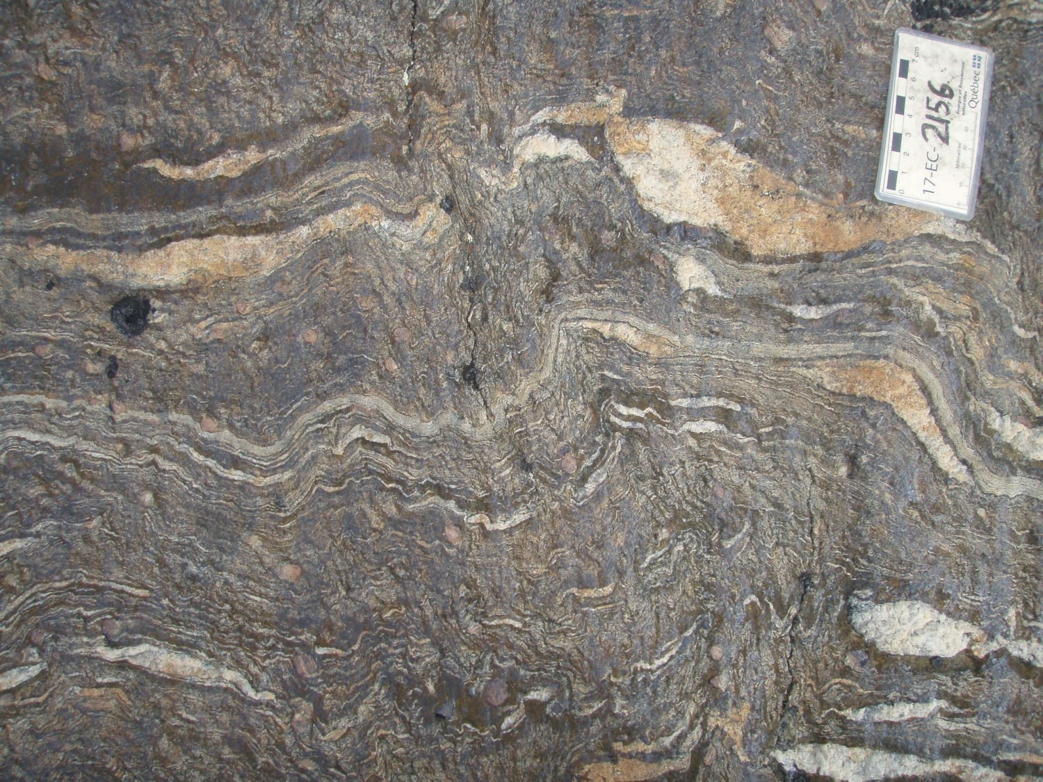
This unit is located in the Roberts Synclinal’s eastern flank and south of the Arnaud River in the Brochant River area.Unit pPme5 is found in the Nagvaraaluk Lake area (sheets 25D10 and 25D15), in the eastern flank of the Roberts Syncline (sheets 25C04 and 25D01) and south of the Arnaud River, in the Brochant River area (sheet 24N13). Schist is derived from wacke and mudstoneIt consists essentially of quartz-biotite-muscovite-chlorite ± garnet schist derived from wacke and mudstone that hasve undergone higher metamorphism than other metasedimentaryunits(e.g., unit pPme1a) (Bilodeau and Caron-Côté, 2018). Phyllite has also been observed. The rock is generally fine to medium grained, schistose, banded and folded. The rock has varying proportions of quartz, biotite, muscovite and chlorite, a smaller amounts proportion of garnet locally and contains plagioclase in places.Garnet or biotite porphyroblasts are found locally. Tectonometamorphic banding is marked by millimetre-thick, and more locally centimetre-thick bands, displaying variations in mineral proportions between quartz and mica. Quartz is mostly granoblastic and usually occurs as monomineralic bands.
Mica is mostly fine grained, but biotite is also found in a few places in medium-grained porphyroblasts(Bilodeau and Caron-Côté, 2018). Biotite commonly contains zircon inclusions. Mica emphasizes the main lepidoblastic foliation which is generally parallel to banding. Microscopic observation of samples collected in the Roberts Synclinale shows that mica also adopts, in smaller proportions, of other orientations that may correspond to other generations of less penetrative schistosity. Mica also marks CS structuresfabrics in shear zones. Garnet is usuallycommonly porphyroblastic and poikilitic, locally helicitic. Inclusions in garnet are mostly quartz and more locally biotite. Accessory mineral phases are epidote, titanite and very locally tourmaline. This subunits’ mineralogical assemblage of this subunit suggests metamorphism at the amphibolite facies (Bilodeau and Caron-Côté, 2018).
Menihek Formation 6 (pPme6): Massive and Pillow Basalt; Minor Proportions of Tuff Locally
This uUnit pPme6 consists of massive and pillow flows of tholeiitic basalt which mayand minor proportions include of tuff in places(Baragar, 1967; Dimroth, 1978).These rocks are mainly located in the south-central part of the Labrador Trough (sheets 23O E and 23J16) where they are at the top of the formation. In the Labrador Trough’s southern part, massive basalt flows are widespread in the Menihek Formation, while pillow basalt flows are scarce (Baragar, 1967; Dimroth, 1978). Flows are generally between 5 and 20 m thick.A breccia of hyaloclastic material a few centimetres thick is usually present at the base or top of the flows. Massive flows are commonly divided into columns. Pillows are sometimes packed together and are generally surrounded by a black crust of hyaloclastic material (Dimroth, 1978). In the Walsh Lake area (sheet 23O01), poorly preserved variolitic crusts were observed around pillows by Baragar (1967).Pillows commonly contain parallel, tabular cavities filled with quartz (Dimroth, 1978). Basalt is light grey in fresh exposure and has a light greenish grey to buff alteration patina (Baragar, 1967; Frarey, 1967; Dimroth, 1978). It is fine grained to aphanitic, with grain sizes ranging from less than 0.1 mm at the edge of flows and in the pillow areas, to about 1 mm in the massive zones (Dimroth, 1978). In thin section, basalt contains plagioclase microliths 0.2 mm long, generally forked and empty, in a very fine-grained brownish matrix composed of pyroxene (augite), plagioclase, chlorite and titanite. Plagioclase phenocrystals 2 cm long and 0.5 mm thick are also observed (Baragar, 1967; Dimroth, 1978).
Pillow flows were observed by Baragar (1967) west of Irène Lake (sheet 23O10) and by Dimroth (1978) in the Aubin Lake area (sheet 23O07). According to Gebert (1991), no pillows were observed in the Frederickson Lake area (sheet 23O01). Flows are 5 to 20 m thick. They are massive in the centre and pillowed at the top, sometimes at the base. Pillows usually contain parallel, tabular cavities filled with quartz (Dimroth, 1978).
Menihek Formation 7 (pPme7): Mafic PyroclasticsVolcaniclastic Rocks
Unit pPme7 consists of greenish mafic volcaniclastic rocks made up of lapilli tuff, agglomerate and volcanic breccia (Baragar, 1958, 1967).In the Murdoch River area (sheet 23O10) and further south in the Jean Lake area (sheet 23O07), tThese rocks are associated with the basaltic unit (pPme6) and form layers 3 to 60 m thick (Dimroth, 1978) at the base of the volcanic pile (Baragar, 1967). In places, they are interbedded in the underlying sedimentary rocks (Baragar, 1967). Volcaniclastic rocks are composed of basaltic and gabbroic fragments in a sheared basaltic matrix of chlorite, actinote, albite, calcite and titanite (Dimroth, 1978). Fragment sizes range from 1 to 7.5 cm and can reach more than 30 cm in diameter (Baragar, 1967; Dimroth, 1978).Mafic pyroclastites include lapilli tuffs, agglomerates and greenish volcanic breccias (Baragar, 1958, 1967). Locally, Dimroth (1978) notes the presence of dolomite and slate fragments.
Menihek Formation 8 (pPme8): Grauwacke and Tuffaceous SiltstoneTuffaceous Wacke and Siltstone; Minor Proportion of Grey or Black Mudstone
Unit pPme8 is restricted to the area east of Martin Lake (sheet 23J16).This subdivision is located east of Martin Lake (sheet 23J16). It consists of a greenish grey grauwacke and tuffaceous wacke and silstone sequence interstratifiebedded with a minor proportion some of grey andor black mudrockstone (Wardle, 1982).
Menihek Formation 9 (pPme9): Sulphide Facies Iron Formation With Sulphides
This subdivision is located in the Frederickson Lake area (sheet 23O01)Unit pPme9 consists of layers of iron formation with sulphides and belongs to the upper half of the Menihek Formation (Baragar, 1967; Dimroth, 1978).The suplhides iron formation locally forms layers >30m thick that can be traced for several kilometres in the area west of lakes Connolly and Frederickson (sheet 23O01). The iron formation is laminated and shows very fine-grained alternating bands of black mudstone and siltstone, and sulphides-rich (Baragar, 1967; Gebert, 1991). Band thickness ranges from 1 to 10 mm. Gebert (1991) notes that bedding is locally displaced by several millimetres due to intraformational fractures. Mudstone and siltstone bands are sorted and sulphides are usually found in the fine-grained fraction. Sulphides (0.01 mm in diameter) consist of pyrrhotite and partially recrystallizedpyrite. Petrographic studies of polished thin sections show that pyrrhotite is more abundant than pyrite, which accounts for <10% of sulphides. Pyrrhotite is observed in metamorphic intergrowth with silicate minerals. In places, it has developed along cleavage planes where deformation is present (Gebert, 1991).study
Menihek Formation 10 (pPme10): Grey-Chert-Pebble Conglomerate
This subdivisionUnit pPme10 is located at the upper contact with the carbonate facies of the Sokoman Formation (pPso3) at Bergeron Lake (sheet 24F05)(Tom Clark, personal communication, 2015). It consists of a bed of grey-chert-pebble conglomerates that are millimetres to decimetre-sized. The bed is discontinuous laterally. The overlying pebble conglomerate and sandstone (unit pPme3) are associated with small normal faults, suggesting a change in tectonic conditions at the end of the Sokoman Formation’s deposition.
Thickness and Distribution
The Menihek Formation spans outcrops over much of the Labrador Trough, stretching more than 850 km from the Grenville Front to Ungava Bay in a NNW-SSE axis. On the Quebec side, this formation occursoutcrops mainly in the northern and southern ends of the orogen, as well as in its central part. The original thickness of this formation is difficult to determine since it is intensely folded into a synclinorium (Dimroth, 1978). The Menihek Formation outcropsAt the northern end of the Labrador Trough, the Menihek Formation outcrops along a cartographic width ranging from 0.5 to 4 km in the flanks of Roberts Synclinal’se flanks, where the stratigraphy is heavily folded and subvertically inclined. This formation extends over larger widths where the thickness of the stratigraphy is lower, reaching up to 30 km wide in the central part and up to 10 km in the southern part of the Labrador Trough‘s southern part.
In the southern part of the orogen, the original thickness of this formation is difficult to determine as it is intensely folded into a synclinorium (Dimroth, 1978). The apparent thickness of sedimentary units (pPme, pPme1 and pPme2) does not exceed 180 m in its western part and is probably >900 m towards the east. In the eastern zone, sedimentary rocks in the lower part of the formation are estimated to be >600 m thick in the Oiseaux Lake area (sheet 23O07). Basalt (pPme6) forms two discontinuous bands that disappear rapidly following the orientation of the layers. East of lakes Simonet and Pointel (sheet 23O07), basalt is ~150 m thick, while it reaches a thickness of ~600 m east of Aubin Lake (sheet 23O07). In the central part of the orogen, the formation reaches a thickness of >180 m in the area NW of Hématite Lake (sheet 24C10), where it forms a large open syncline (Dressler, 1979). Further north, in the area west of La Lande Lake (sheet 24F03), Dressler (1979) indicates that the formation is thicker, estimating a thickness of ~300 to 400 m.
Dating
Fryer (1972) dated a Menihek Formation sedimentary rock using the Rb/Sr isochron method of whole rock and obtained an age of 1855 ±74 Ma. However, he does not specify the geographic location of the sample.
Stratigraphic Relationship(s)
The Menihek Formation overlies ferriferous rocks of the Sokoman Formation. The nature of the contact between the two seems to vary by sector. According to Dimroth (1978), contact is generally sharp and conformable, although locally unconformable. According to Baragar (1968, Iron Ore Company of Canada. In: Dimroth, 1978), contact can be of a discordant nature since he observed ferriferous rock conglomerates were observed between the Sokoman and Menihek formations, suggesting an erosion period between the deposition of these two formations. Interfingered cContacts between the Menihek and Sokoman formations have also been observed in the southern end of the Labrador Trough were observed (Zajac, 1974).
In eastern portion of the southern part of the Labrador Trough, the Menihek Formation is in faulted contact (Walsh Lake Fault) with the Murdoch Formation (Frarey, 1967; Wardle and Bailey, 1981Baragar, 1967; Frarey, 1967; Wardle and Bailey, 1981). According to Baragar (1967), the presence of the lake Walsh FaultWalsh Lake Fault make it difficult to interpret their stratigraphic relationships. The lower, median and upper parts of the Menihek Formation were correlated, respectively, with rocks of the Murdoch, Thompson Lake and Willbob formations belonging to the Doublet Group (Findlay et al., 1995). The upper part of the Menihek Formation is injected with numerous glomeroporphyritic gabbro sills belonging to the Gerido Intrusive Suite (Findlay et al., 1995). The Nault Formation, located south of the Grenville Front, is equivalent to the Menihek Formation (Dimroth et al., 1970; Rivers, 1980).
Two U-Pb datings were performed in two different areas to constrain the age of the Menihek Formation: 1) Dyke Lake area (sheet 23J09), 40 km southeastSE of Schefferville and iin the western portion of the New Quebec Orogen; and 2) Howse Lake area (sheets 23O01 and 23O02), 40 km northeastNE of Schefferville and in a more eastern part of the orogen (Findlay et al., 1995). In the Dyke Lake area, an age of 1877.8 ±1.3 Ma was obtained from a syenite clast in a conglomerate interstratified with the Sokoman Formation, underlying the Menihek Formation.In the Dyke Lake area, an age of 1878 ±1 Ma was obtained for a syenite pebble from a conglomerate interbedded in the felsic volcanic rocks of the Nimish Volcanic Complex, contemporary with the deposition of the rocks of the Sokoman Formation. This date provides a minimum age ofat sedimentation slightly prior to the Menihek Formation in this area. In the Howse Lake area, a crystallization age of 1884 ±2 Ma was obtained for onea sill of the Gerido Intrusive Suite (Montagnais Supersuite) sills cutting hosted in the Menihek Formation. This results in a maximum age of sedimentation for the Menihek Formation in this area. This geochronological data suggests the Menihek Formation’s rejuvenation to the southwestSW; a hypothesis that is consistent with a marine transgression in the same direction (Findlay et al., 1995).
In the northern half of the orogen (north of the Mélèzes River), the Menihek Formation is structurally overlain by rocks of the Denault Formation (Attikamagen Group), which are followed by rocks of the Koksoak Group. This relationship is caused by the presence of the Garigue Fault. The discovery of the latter allowed the Menihek Formation to be correlated with the Upper Baby member, which belongs to the Koksoak Group (Clark, 1987). The Menihek and Chioak formations are homotaxial in that they are both overlying the Sokoman Formation (Clark, 1979, 19878). At the northern end of the orogen, the Menihek Formation is overlain by the Hellancourt Formation (Koksoak Group). In the Roberts Synclineal, Bilodeau and Caron-Côté (2018) observed alternating and conformable contact between the Menihek and Hellancourt formations. In the southern part of the orogen, the summital portion of the Menihek Formation is intruded by numerous glomeroporphyric gabbro sills belonging to the Gerido Intrusive Suite (formely Montagnais Sills) (Findlay et al., 1995). The Nault Formation, located south of the Grenville Front, is equivalent to the Menihek Formation (Dimroth et al., 1970; Rivers, 1980).
Paleontology
Dressler (1979) reported cone structures nested in the Menihek Formation east of Chocolat Lake (sheet 24C10).
References
Publications Available Trough SIGÉOM Examine
BERARD, J., 1965. REGION DU LAC BERARD, NOUVEAU-QUEBEC. MRN; RG 111, 175 pages, 2 plans.
BERGERON, R., 1956. RAPPORT PRELIMINAIRE SUR LA REGION DU LAC HARVENG (MOITIE OUEST), NOUVEAU-QUEBEC. MRN; RP 320, 9 pages, 1 plan.
BILODEAU, C., CARON-COTE, E., 2018. Géologie de la région de la rivière Arnaud, provinces du Supérieur (Minto) et de Churchill (Fosse du Labrador), secteur de Kangirsuk, Nunavik, Québec, Canada. MERN; BG 2018-04, 2 plans.
CIESIELSKI, A., 1975. CONTACT ARCHEEN-PROTEROZOIQUE ENTRE LES LACS FORBES ET SENAT (FOSSE DU LABRADOR) – RAPPORT PRELIMINAIRE. MRN; DPV 449, 28 pages, 1 plan.
CLARK, T., 1977. GEOLOGY OF THE FORBES LAKE AREA (NOUVEAU-QUEBEC). MRN; DPV 452, 19 pages, 1 plan.
CLARK, T., 1979. REGION DU LAC NAPIER (NOUVEAU-QUEBEC) – RAPPORT PRELIMINAIRE. MRN; DPV 663, 28 pages, 1 plan.
CLARK, T., 1987. STRATIGRAPHIE, PETROGRAPHIE ET PETROCHIMIE DE LA FORMATION DE FER DE BABY DANS LA REGION DU LAC HERODIER (FOSSE DU LABRADOR). MRN; ET 87-13, 44 pages.
CLARK, T., LECLAIR, A., PUFAHL, P., DAVID, J., 2008. RECHERCHE GEOLOGIQUE ET METALLOGENIQUE DANS LES REGIONS DE SCHEFFERVILLE (23J15) ET DU LAC ZENI (23I16). COMMISSION GEOLOGIQUE DU CAN, UNIVERSITE ACADIA, MRNF, GEOTOP UQAM-MCGILL; RP 2008-01, 17 pages.
CLARK, T., WARES, R., 2004. SYNTHESE LITHOTECTONIQUE ET METALLOGENIQUE DE L’OROGENE DU NOUVEAU-QUEBEC (FOSSE DU LABRADOR). MRNFP; MM 2004-01, 182 pages, 1 plan.
DIMROTH, E., 1978. Région de la fosse du Labrador entre les latitudes 54° 30′ et 56° 30′. MRN; RG 193, 417 pages, 16 plans.
DRESSLER, B., 1973. GEOLOGIE DE LA REGION DU LAC PATU, TERRITOIRE DU NOUVEAU-QUEBEC. MRN; RP 603, 26 pages, 1 plan.
DRESSLER, B., 1975. GEOLOGIE DE FORT MCKENZIE, CHUTE AUX SCHISTES (1/2E), LAC MORAINE (1/2E), NOUVEAU-QUEBEC. MRN; RP 608, 32 pages, 1 plan.
DRESSLER, B., CIESIELSKI, A., 1979. Région de la fosse du Labrador. MRN; RG 195, 136 pages, 14 plans.
GEBERT, J., 1991. METALLOGENIE DES INDICES DE CU-NI ET DE ZN-CU-PB DANS LA REGION DU LAC FREDERICKSON (FOSSE DU LABRADOR). MRN; ET 88-04, 75 pages, 1 plan.
HARDY, R., 1976. Région des lacs Roberts – des Chefs. MRN; RG 171, 109 pages, 2 plans.
SAUVE, P., BERGERON, R., 1965. REGION DES LACS GERIDO ET THEVENET, NOUVEAU-QUEBEC. MRN; RG 104, 141 pages, 3 plans.
SAUVE, P., BERGERON, R., 1965. GERIDO LAKE – THEVENET LAKE AREA, NEW QUEBEC. MRN; RG 104(A), 131 pages, 3 plans.
BERARD, J., 1957a. PRELIMINARY REPORT ON FINGER LAKE AREA, NEW QUEBEC. MRN; RP 360(A), 7 pages, 1 plan.
BERARD, J., 1957b. Preliminary report on Bones lake area, New Quebec. MRN; RP 342(A), 8 pages, 1 plan.
BERARD, J., 1957a. RAPPORT PRELIMINAIRE SUR LA REGION DU LAC FINGER, NOUVEAU-QUEBEC. MRN; RP 360, 9 pages, 1 plan.
BERARD, J., 1957b. Rapport préliminaire sur la région du lac Bones, Nouveau-Québec. MRN; RP 342, 10 pages, 1 plan.
BERARD, J., 1959. Preliminary report on Leaf lake area, New Quebec. MRN; RP 384(A), 8 pages, 1 plan.
BERARD, J., 1959. Rapport préliminaire sur la région du lac aux Feuilles, Nouveau-Québec. MRN; RP 384, 10 pages, 1 plan.
BERARD, J., 1965. BERARD LAKE AREA, NEW QUEBEC. MRN; RG 111(A), 148 pages, 2 plans.
BERARD, J., 1965. REGION DU LAC BERARD, NOUVEAU-QUEBEC. MRN; RG 111, 175 pages, 2 plans.
BERGERON, R., 1956. PRELIMINARY REPORT ON HARVENG LAKE AREA, (WEST HALF), NEW QUEBEC. MRN; RP 320(A), 6 pages, 1 plan.
BERGERON, R., 1956. RAPPORT PRELIMINAIRE SUR LA REGION DU LAC HARVENG (MOITIE OUEST), NOUVEAU-QUEBEC. MRN; RP 320, 9 pages, 1 plan.
BERGERON, R., 1957. Preliminary report on Brochant – de Bonnard area, New Quebec. MRN; RP 348(A), 7 pages, 1 plan.
BERGERON, R., 1957. Rapport préliminaire sur la région de Brochant – de Bonnard, Nouveau-Québec. MRN; RP 348, 9 pages, 1 plan.
BILODEAU, C., CARON-COTE, E., 2018. Géologie de la région de la rivière Arnaud, provinces du Supérieur (Minto) et de Churchill (Fosse du Labrador), secteur de Kangirsuk, Nunavik, Québec, Canada. MERN; BG 2018-04, 2 plans.
BILODEAU, C., CLARK, T., NADEAU, J., 2011. COMPILATION GEOLOGIQUE – KYAK BAY. MRNF; CG-25C04-2011-01, 1 plan.
BILODEAU, C., CLARK, T., NADEAU, J., 2012a. COMPILATION GEOLOGIQUE – LAC FORD. MRNF; CG-24M01-2012-01, 1 plan.
BILODEAU, C., CLARK, T., NADEAU, J., 2012b. COMPILATION GEOLOGIQUE – LAC MORGAN. MRNF; CG-24M16-2012-01, 1 plan.
BILODEAU, C., CLARK, T., NADEAU, J., 2012c. COMPILATION GEOLOGIQUE – LAC SAINT-FOND. MRNF; CG-24M08-2012-01, 1 plan.
CIESIELSKI, A., 1975. CONTACT ARCHEEN-PROTEROZOIQUE ENTRE LES LACS FORBES ET SENAT (FOSSE DU LABRADOR) – RAPPORT PRELIMINAIRE. MRN; DPV 449, 28 pages, 1 plan.
CLARK, T., 1977. GEOLOGY OF THE FORBES LAKE AREA (NOUVEAU-QUEBEC). MRN; DPV 452, 19 pages, 1 plan.
CLARK, T., 1979. REGION DU LAC NAPIER (NOUVEAU-QUEBEC) – RAPPORT PRELIMINAIRE. MRN; DPV 663, 28 pages, 1 plan.
CLARK, T., 1984. GEOLOGIE DE LA REGION DU LAC CAMBRIEN – TERRITOIRE DU NOUVEAU-QUEBEC. MRN; ET 83-02, 77 pages, 1 plan.
CLARK, T., 1987. STRATIGRAPHIE, PETROGRAPHIE ET PETROCHIMIE DE LA FORMATION DE FER DE BABY DANS LA REGION DU LAC HERODIER (FOSSE DU LABRADOR). MRN; ET 87-13, 44 pages.
CLARK, T., 2019. Compilation géologique, lac Harveng. MERN; CG-2019-01, 1 plan.
CLARK, T., LECLAIR, A., PUFAHL, P., DAVID, J., 2008. RECHERCHE GEOLOGIQUE ET METALLOGENIQUE DANS LES REGIONS DE SCHEFFERVILLE (23J15) ET DU LAC ZENI (23I16). COMMISSION GEOLOGIQUE DU CAN, UNIVERSITE ACADIA, MRNF, GEOTOP UQAM-MCGILL; RP 2008-01, 17 pages.
CLARK, T., WARES, R., 2004. SYNTHESE LITHOTECTONIQUE ET METALLOGENIQUE DE L’OROGENE DU NOUVEAU-QUEBEC (FOSSE DU LABRADOR). MRNFP; MM 2004-01, 182 pages, 1 plan.
DIMROTH, E., 1965. GEOLOGIE DE LA REGION DU LAC OTELNUK, TERRITOIRE DU NOUVEAU-QUEBEC. MRN; RP 532, 30 pages, 1 plan.
DIMROTH, E., 1965. PRELIMINARY REPORT, GEOLOGY OF OTELNUK LAKE AREA, NEW QUEBEC TERRITORY. MRN; RP 532(A), 27 pages, 1 plan.
DIMROTH, E., 1970. CARTES GEOLOGIQUES DU LAC ROMANET ET DU LAC CRAMOLET (FOSSE DU LABRADOR). MRN; DP 068, 3 plans.
DIMROTH, E., 1978. Région de la fosse du Labrador entre les latitudes 54° 30′ et 56° 30′. MRN; RG 193, 417 pages, 16 plans.
DRESSLER, B., 1973. GEOLOGIE DE LA REGION DU LAC PATU, TERRITOIRE DU NOUVEAU-QUEBEC. MRN; RP 603, 26 pages, 1 plan.
DRESSLER, B., 1975. GEOLOGIE DE FORT MCKENZIE, CHUTE AUX SCHISTES (1/2E), LAC MORAINE (1/2E), NOUVEAU-QUEBEC. MRN; RP 608, 32 pages, 1 plan.
DRESSLER, B., 1979. Région de la fosse du Labrador. MRN; RG 195, 136 pages, 14 plans.
FREEDMAN, R. O., PHILPOTTS, J. A., 1958. REPORT ON RED DOG LAKE AREA (UNGAVA). MRN; DP 049, 13 pages, 1 plan.
GEBERT, J., 1991. METALLOGENIE DES INDICES DE CU-NI ET DE ZN-CU-PB DANS LA REGION DU LAC FREDERICKSON (FOSSE DU LABRADOR). MRN; ET 88-04, 75 pages, 1 plan.
GOLD, D. P., 1962. PRELIMINARY REPORT ON HOPES ADVANCE BAY AREA, NEW QUEBEC. MRN; RP 442(A), 11 pages, 1 plan.
GOLD, D. P., 1962. RAPPORT PRELIMINAIRE SUR LA REGION DE LA BAIE HOPES ADVANCE, NOUVEAU-QUEBEC. MRN; RP 442, 13 pages, 1 plan.
HARDY, R., 1976. Région des lacs Roberts – des Chefs. MRN; RG 171, 109 pages, 2 plans.
LAFRANCE, I., BANDYAYERA, D., SIMARD, M., 2012. GEOLOGIE – GORGE DU MANITOU. MRN; CG-24F11-2012-01, 1 plan.
MADORE, L., LARBI, Y., 2000. GEOLOGIE DE LA REGION DE LA RIVIERE ARNAUD (SNRC 25D) ET DES REGIONS LITTORALES ADJACENTES (SNRC 25C, 25E, 25F). MRN; RG 2000-05, 39 pages, 4 plans.
MRNF, 2010a. CARTE(S) GÉOLOGIQUE(S) DU SIGEOM – feuillet 23J. CG SIGEOM23J, 9 plans.
MRNF, 2010b. CARTE(S) GÉOLOGIQUE(S) DU SIGEOM – feuillet 23N. CG SIGEOM23N, 1 plan.
MRNF, 2010c. CARTE(S) GÉOLOGIQUE(S) DU SIGEOM – feuillet 23O. CG SIGEOM23O, 16 plans.
MRNF, 2010d. CARTE(S) GÉOLOGIQUE(S) DU SIGEOM – feuillet 24C. CG SIGEOM24C, 14 plans.
MRNF, 2010e. CARTE(S) GÉOLOGIQUE(S) DU SIGEOM – feuillet 24E. CG SIGEOM24E, 4 plans.
MRNF, 2010f. CARTE(S) GÉOLOGIQUE(S) DU SIGEOM – feuillet 24F. CG SIGEOM24F, 16 plans.
MRNF, 2010g. CARTE(S) GÉOLOGIQUE(S) DU SIGEOM – feuillet 24K. CG SIGEOM24K, 16 plans.
MRNF, 2010h. CARTE(S) GÉOLOGIQUE(S) DU SIGEOM – feuillet 24L. CG SIGEOM24L, 5 plans.
MRNF, 2010i. CARTE(S) GÉOLOGIQUE(S) DU SIGEOM – feuillet 24M. CG SIGEOM24M, 5 plans.
MRNF, 2010j. CARTE(S) GÉOLOGIQUE(S) DU SIGEOM – feuillet 24N. CG SIGEOM24N, 6 plans.
MRNF, 2010k. CARTE(S) GÉOLOGIQUE(S) DU SIGEOM – feuillet 25C. CG SIGEOM25C, 2 plans.
MRNF, 2010l. CARTE(S) GÉOLOGIQUE(S) DU SIGEOM – feuillet 25D. CG SIGEOM25D, 6 plans.
SAUVE, P., BERGERON, R., 1965. REGION DES LACS GERIDO ET THEVENET, NOUVEAU-QUEBEC. MRN; RG 104, 141 pages, 3 plans.
SAUVE, P., BERGERON, R., 1965. GERIDO LAKE – THEVENET LAKE AREA, NEW QUEBEC. MRN; RG 104(A), 131 pages, 3 plans.
Other Publications
BARAGAR, W. R. A. 1958. Ahr Lake map-area, New Quebec (23O/10). Geological Survey of Canada; Paper 57-7, 9 pages. https://doi.org/10.4095/104037
BARAGAR, W. R. A. 1967. Wakuach Lake map-area, Quebec-Labrador. Geological Survey of Canada; Memoir 344, 174 pages. https://doi.org/10.4095/123960
BERGERON, R. 1954. A study of the Quebec-Labrador iron belt between Derry Lake and Larch River. Thèse de doctoratPh.D. thesis, Université Laval, Québec.
DIMROTH, E., BARAGAR, W. R. A., BERGERON, R., JACKSON, G. D. 1970. The filling of the Circum-Ungava Geosyncline. In: Symposium on basins and geosynclines of the Canadian Shield (A.J. Baer, editor). Geological Survey of Canada; Paper 70-40, pages 45-142. https://doi.org/10.4095/124922
EVANS, J.L. 1978. The geology and geochemistry of the Dyke Lake area (parts of 23J8, 9), Labrador. Newfoundland Department of Mines and Energy, Mineral Development Division; Report 78-4, 43 pages. http://gis.geosurv.gov.nl.ca/geofilePDFS/WBox040/023J_0058.pdf
FINDLAY, J. M., PARRISH, R. R., BIRKETT, T., WATANABE, D. H. 1995. U-Pb ages from the Nimish Formation and Montagnais glomeroporphyritic gabbro of the central New Québec Orogen, Canada. Canadian Journal of Earth Sciences; volume 32, pages 1208-1220. https://doi.org/10.1139/e95-099
FRAREY, M.J. 1961. Menihek Lakes, Newfoundland and Québec; Geological Survey of Canada; Map 1087A. https://doi.org/10.4095/124105
FRAREY, M. J. 1967. Willbob Lake and Thompson Lake map-areas, Quebec and Newfoundland. Geological Survey of Canada; Memoir 348, 73 pages. https://doi.org/10.4095/123896
FRAREY, M. J., DUFFEL, S. 1964. Revised stratigraphic nomenclature for the central part of the Labrador Trough. Geological Survey of Canada; Paper 64-25, 13 pages. https://doi.org/10.4095/123909
FRYER, B. J. 1972. Age determinations in the Circum-Ungava Geosyncline and the Evolution of Precambrian Banded Iron-Formations. Canadian Journal of Earth Sciences; volume 9, pages 652-663. https://doi.org/10.1139/e72-055
HARRISON, J. M. 1952. The Quebec-Labrador iron belt, Quebec and Newfoundland. Geological Survey of Canada; Paper 52-20, 21 pages. https://doi.org/10.4095/123923
RIVERS, T. 1980. Revised stratigraphic nomenclature for Aphebian and other rock units, southern Labrador Trough, Grenville Province. Canadian Journal of Earth Sciences, volume 17, pages 668-670. https://doi.org/10.1139/e80-062
WARDLE, R. J. 1979. Geology of the eastern margin of the Labrador Trough. Department of Mines and Energy, Government of Newfoundland and Labrador; Report 78-9, 22 pages. https://gis.geosurv.gov.nl.ca/geofilePDFS/WBox040/LAB_0415.pdf
WARDLE, R. J., BAILEY, D. G. 1981. Early Proterozoic sequences in Labrador. In: Proterozoic Basins in Canada (F.H.A. Campbell, editor). Geological Survey of Canada; Study 81-10, pages 331-359. https://doi.org/10.4095/124192
ZAJAC, I. S. 1974. The stratigraphy and mineralogy of the Sokoman formation in the Knob Lake area, Quebec and Labrador. Geological Survey of Canada; Bulletins 220, 159 pages. https://doi.org/10.4095/123946
Suggested Citation suggérée
Ministère de l’Énergie et des Ressources naturelles (MERN)Ministère des Ressources naturelles et des Forêts (MRNF). Menihek Formation. Quebec Stratigraphic Lexicon. https://gq.mines.gouv.qc.ca/lexique-stratigraphique/province-de-churchill/formation-de-menihek_en/ [accessed on Day Month Year].
Contributors
|
First publication |
Charles St-Hilaire, GIT, M.Sc. charles.st-hilaire@mern.gouv.qc.ca; Emmanuel Caron-Côté, P. Geo., M.Sc. emmanuel.caron-cote@mern.gouv.qc.ca (redaction) Mehdi A. Guemache, P. Geo., Ph.D. (coordination); Mélina Langevin, B.Sc. (critical review); Simon Auclair, P. Geo., M.Sc. (editing); Céline Dupuis, P. Geo., Ph.D. (English version); Nathalie Bouchard (HTML editing). |
|
Revision(s) |
Charles St-Hilaire, GIT, M.Sc. (redaction) Mehdi A. Guemache, P. Geo., Ph.D. (coordination); Céline Dupuis, P. Geo., Ph.D. (critical review and editing). |