

First published: 9 December 2020
Last modified: 15 March 2021
DISCLAIMER: This English version is translated from the original French. In case of any discrepancy, the French version shall prevail.
| Author(s): | Frarey and Duffell, 1964 |
| Age: | Paleoproterozoic |
| Stratotype: | None |
| Type area: | Seward Lake area, Labrador (NTS sheet 23I05) |
| Geological province: | Churchill Province |
| Geological subdivision: | New Quebec Orogen (Labrador Trough) / Cambrien, Howse, Romanet (formerly Wheeler) and Schefferville lithotectonic zones |
| Lithology: | Arkose, conglomerate, siltstone, sandstone, quartzitic arenite and trachybasalt |
| Category: | Lithostratigraphic |
| Rank: | Group |
| Status: | Formal |
| Use: | Active |
Background
The Seward name has been used in several ways as knowledge of the stratigraphy of the Labrador Trough has increased. It was known to Labrador Mining and Exploration geologists in 1949 as the Seward Beds. This unit consisted of coarse-grained sandstones (grits), arkoses, conglomerates, white or pink quartzites and greywackes. The Seward Beds were part of the Hamilton River Series and occupied the base of the Knob Lake Group (a term introduced by Harrison, 1952, now abandoned) and also the base of the global stratigraphic column of the Labrador Trough. The name Hamilton River Series was abandoned (Harrison, 1952). Frarey and Duffell (1964) introduced the Seward Formation in the southern part of the Trough, named after a lake in Labrador (sheet 23I05). Baragar (1967) followed the Seward Formation northwards to latitude 56°N (sheet 23W). He describes the unit as consisting mainly of red to pink sedimentary strata, which include sandstone, conglomerate, siltstone, shale, dolomite and limestone. Near Musset Lake (sheets 23O06, 23O11), Baragar (1967) noted the presence of a volcanic unit underlying sedimentary rocks of the Seward Formation, but did not include it in the formation due to incomplete data.
While mapping in the north-central part of the Labrador Trough, i.e. in Quebec, Dimroth (1968) divided the Seward Formation into four formations (Chakonipau, Portage, Dunphy and Milamar) and elevated it to the rank of « subgroup », thus creating the Seward Subgroup. According to Dimroth (1978), the Chakonipau Formation is predominantly composed of sandstone, conglomerate and siltstone of fluvial origin and deposited in a continental rift. Dimroth (1978) included as a member of the Chakonipau Formation the volcanic unit that Baragar (1967) had identified near Lake Musset. The Portage, Dunphy and Milamar formations (overlying the Chakonipau Formation) consist of sandstone, mudstone and dolomite, which were deposited as a result of marine incursion (Dimroth, 1978).
In the south-central Labrador Trough, i.e. in Labrador, Wardle (1979) divided the Seward Formation into three informal members named the Lower Seward formation, Middle Seward formation and Upper Seward formation. Based on the mapping work of Dimroth (1968, 1969, 1978) in Quebec, Wardle and Bailey (1981) extended the use of the name Seward Subgroup to Labrador, abandoning the Seward Formation. They also informally assigned a formation « rank » to members of Wardle (1979) and proposed the informal names Discovery Lake, Snelgrove Lake and Sawyer Lake as subdivisions of the Seward Subgroup in this part of the Labrador Trough. In ascending order, the Discovery Lake and Snelgrove Lake formations are equivalent to the Chakonipau Formation, and the Sawyer Lake Formation represents the homotaxial equivalent of the Portage, Dunphy and Milamar formations.
Since the North American Stratigraphic Code (NACSN, 1983, 2005) does not recognize the existence of the « subgroup » rank, Clark and Wares (2004) reclassified the Seward Subgroup as the Seward Group. This change also resulted in the name Knob Lake Group being abandoned (Clark and Wares, 2004). Thus, the Chakonipau, Portage, Dunphy and Milamar formations (Dimroth, 1968), as well as the Discovery Lake, Snelgrove Lake and Sawyer Lake formations (Wardle and Bailey, 1981) are part of the Seward Group.
Description
The Seward Group is part of the first volcano-sedimentary cycle of the Labrador Trough (Dimroth, 1969; Clark and Wares, 2004). It comprises several formations at the base of the sedimentary succession in the Trough. The Chakonipau Formation is the lowermost formation of the group. It is overlain by three laterally equivalent formations which are, from west to east: the Portage, Dunphy and Milamar formations (Dimroth, 1970, 1978). The Chakonipau Formation consists mainly of pink or red arkose and conglomerate. It also includes mudstone, siltstone, trachybasalt and paraschist. Sedimentary rocks of the Chakonipau Formation are of fluvial origin (Baragar, 1967; Dimroth, 1970, 1978; Rohon et al., 1993). The Portage Formation, located near the western margin of the Trough, consists of pink or red arkose, quartzitic arenite, dolomite, dolomitic sandstone, siltstone, mudstone, calcarenite, marble and schist. These rocks are of mixed fluvial and marine origin (Clark and Wares, 2004). The Portage Formation is distinguished from the Chakonipau Formation mainly by the presence of dolomitic sedimentary rocks.
The Dunphy Formation, located in the central part of the Trough, consists of dolomite, locally stromatolitic, sandy dolomite, mudstone, chert and marble. Sedimentary rocks of the Dunphy Formation are of marine origin (Dimroth, 1972, 1978). The Milamar Formation, located near the Wheeler Dome in the eastern part of the Trough, consists of arkose, conglomerate, quartzitic arenite, dolomitic sandstone, dolomite, marble and schist. Rhese sedimentary rocks were deposited in a coastal environment (Dimroth, 1972, 1978). As with the Portage Formation, the presence of dolomitic strata distinguishes the Milamar Formation from the Chakonipau Formation. Thus, the upper formations of the Seward Group contain sedimentary rocks of fluvial and marine origin. With the exception of the case mentioned below, the Seward Group was mapped in Quebec according to its constituent formations.
In the Colombet Lake area (sheets 24C15 and 24F02), the sedimentary sequence of the Seward Group consists of the following units from base to top: 1) conglomerate with arkosic matrix and granitic pebbles, and arkosic and conglomeratic sandstone and siltstone (pPse1); 2) purple siltstone and sandstone (pPse2); and 3) quartzitic arenite with some sandy dolomite and conglomeratic dolomite (pPse3) (Hashimoto, 1964, 1968; Dressler, 1975, 1979; Girard, 1984a, 1988). A trachybasalt and trachyandesite unit (lavas and pyroclastics; pPse4) was emplaced in sedimentary rocks (pPse1 and pPse2) during sedimentation (Girard, 1984a, 1988). Unit pPse4 is possibly equivalent to volcanic rocks of unit pPcp2 of the Chakonipau Formation. South of Colombet Lake, a fine to medium-grained, pink to dark red-brown sandstone or arkose unit (pPse5) forms the Seward Group (Dressler, 1975, 1979).
Seward Group, Undivided (pPse): Generally Pink or Red Arkose, Conglomerate and Siltstone
This unit consists of arkose, conglomerate and siltstone which are generally pink or red (Dimroth, 1978; Avramtchev et al., 1990; Bilodeau and Clark, 1998).
Seward Group 1 (pPse1): Conglomerate with Arkosic Matrix and Granitic Pebbles; Arkosic and Conglomeratic Sandstone and Siltstone

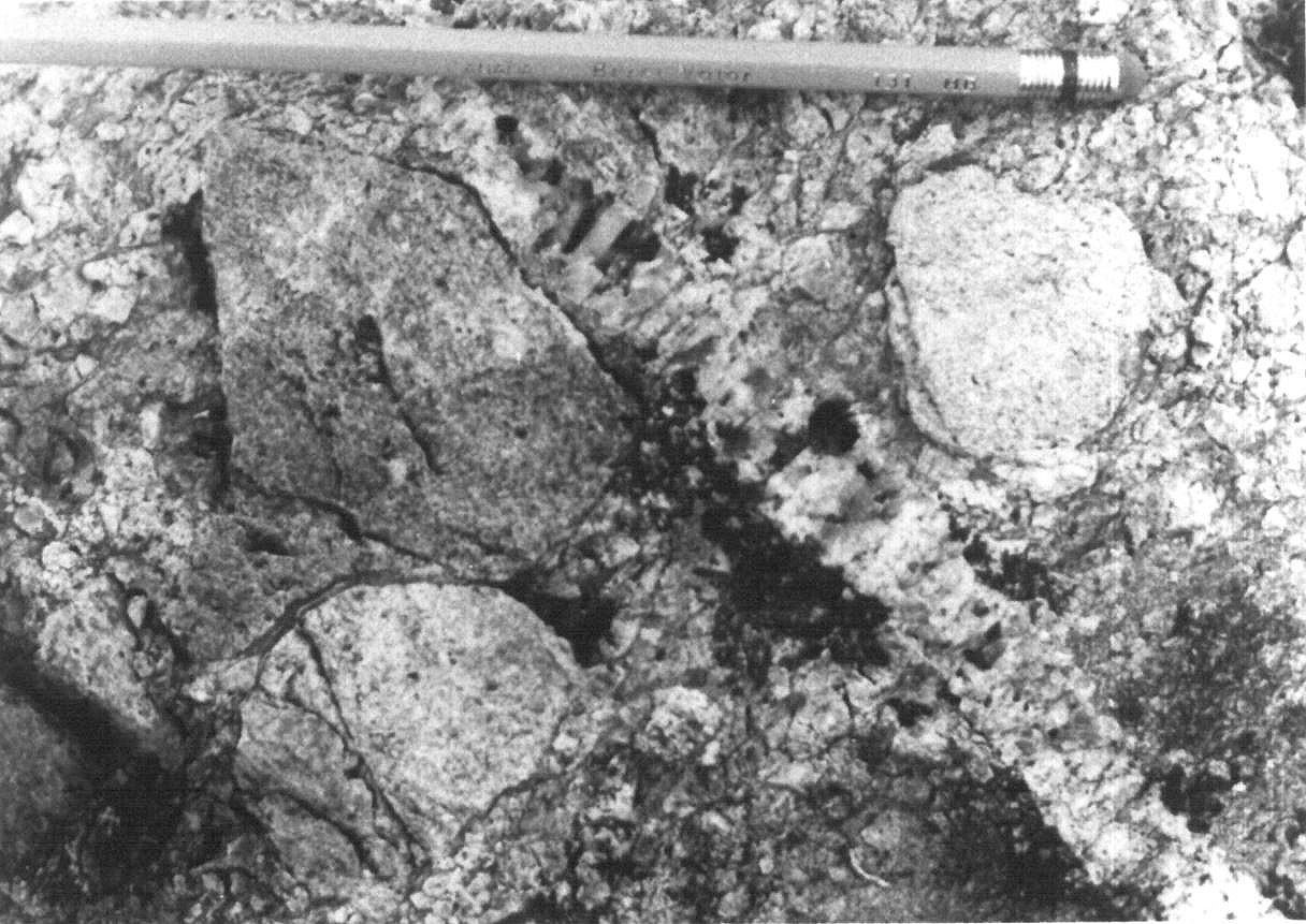
Unit pPse1 was mapped at Colombet Lake (sheets 24C15 and 24F02) by Dressler (1975, 1979) and Girard (1984a, b, 1988). It consists of conglomerate with an arkosic matrix and granitic pebbles as well as arkosic and conglomeratic sandstone and siltstone. The granitic pebble conglomerate bed is 2 to 5 m thick and lies directly on Archean bedrock. It gradually changes upwards to a unit of siltstone and purple sandstone (Pse2) (Girard, 1988). Conglomerate is composed of 20-75% granitic pebbles in a slightly chloritic, locally silty, microconglomeratic or sandy matrix. Pebbles are subangular to subrounded and vary in diameter from 0.5 to 30 cm. Conglomerate’s pebbles and matrix’s ferromagnesian minerals are oriented parallel to the direction of regional schistosity (0 to 30°).
Locally, pebble conglomerate abruptly changes to arkosic and conglomeratic sandstone and siltstone. These rocks contain quartz, K-feldspar and granite pebbles averaging 0.5 cm in diameter (Girard, 1988). Arkosic and conglomeratic sandstone similar in composition to conglomerate overlying bedrock outcrops on the NW part of an island in Colombet Lake (Gabbro Island, Girard, 1984a, 1988). The maximum thickness of the bed observed by Girard (1988) is estimated at 50 m. The rock is pink to beige and contains up to 5% granitic pebbles in a feldspar-rich microconglomeratic matrix. Pebbles are subangular to subrounded and vary in diameter from 2 to 4 cm. Some layers are sandier and have greater amounts of well-rounded quartz grains (Girard, 1988).
According to Girard (1988), poor sorting and the degree of erosion of the conglomerate’s constituents suggests that it was deposited in a depositional environment similar to that of the Chakonipau Formation (Dimroth, 1978).
Seward Group 2 (pPse2): Purple Siltstone and Sandstone
Unit pPse2 was mapped by Hashimoto (1964, 1968), Dressler (1979) and Girard (1984a, 1988) in the Colombet Lake area (sheets 24F02 and 24F03). It consists of purple siltstone and sandstone. These rocks are in gradual contact with underlying conglomerate (Pse1) (Girard, 1988), or unconformably overlie Archean bedrock (Hashimoto, 1964, 1968; Dressler, 1979). Siltstone is well stratified and contains thin sandstone beds in places. Stratification is characterized by beige laminae and sandy or microconglomeratic lenses ~2 to 30 cm thick. Cross bedding is common (Hashimoto, 1968). Slate cleavage is well developed and is apparent in well-developed sheeting. Siltstone is composed of 60-80% clay minerals and 20-40% subrounded quartz and feldspar (microcline and plagioclase) grains (Girard, 1988). The purple colour of the rock is due to the presence of 2 to 5% disseminated hematite in the matrix (Hashimoto, 1964, 1968; Girard, 1988). Girard (1988) noted the presence of kaolinite and saussurite as evidence of alteration of feldspar-rich layers.
Seward Group 3 (pPse3): Quartzitic Arenite; Some Sandy Dolomite and Conglomeratic Dolomite
Unit pPse3 is mainly located in the Colombet Lake area. It consists mainly of quartzitic arenite with lesser amounts of sandy dolomite and conglomeratic dolomite. Its thickness is estimated at ~10 to 15 m (Girard, 1984a, 1988). Dimroth (1978) mapped a similar quartzitic arenite unit in the Luché Lake area (sheet 24C07). At Colombet Lake, quartzitic arenite mostly overlies siltstone (pPse2), although locally in contact with Archean bedrock or conglomerate (pPse1) (Girard, 1984a, 1988). The rock is white to beige, fine to medium grained (0.1-1 mm) and occurs in 0.5 to 1.5 m thick beds. Rare sedimentary structures consist of cross bedding a few centimetres thick in finer-grained layers. Arenite is composed of ~90% quartz and 5-8% slightly altered feldspar in a fine-grained (2-5%) quartz-feldspar matrix. Accessory minerals include apatite, rutile, hematite and chlorite (Girard, 1984a, 1988). The rock may contain up to 20% quartz veins of metamorphic origin (Girard, 1988). Sandy dolomite and conglomeratic dolomite are observed locally; they occur as beds or lenses, 0.3 to 1 m thick, continuous over only a few metres (Girard, 1984a, 1988).
Seward Group 4 (pPse4): Trachybasalt and Trachyandesite (Lavas and Pyroclastics)
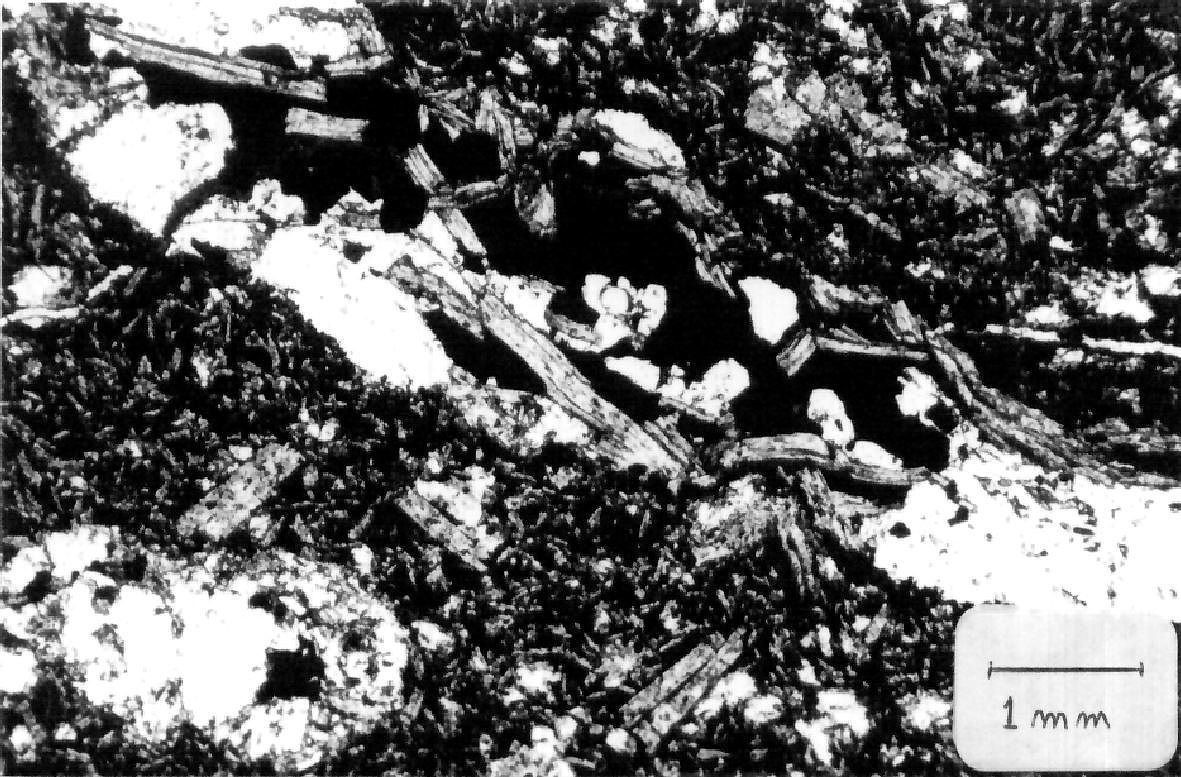
Unit pPse4, consisting of trachybasalt and trachyandesite, was recognized by Girard (1984a, 1988) in the Colombet Lake area. These rocks were emplaced in sedimentary rocks of the Seward Group during sedimentation, and locally cut Archean bedrock as dykes (Girard, 1988). Unit pPse4 may be equivalent to unit pPcp2 of the Chakonipau Formation identified in the Musset Lake area (sheet 23O11) (Baragar, 1967; Brassard, 1984) and in the Mistamisk and Romanet lakes valley (Clark, 1986). According to Girard (1988), trachybasalt appears to be in unconformable contact with conglomerate (pPse1) and siltstone (pPse2). However, this author indicates that this contact is not visible in the field. The trachybasalt layer is 5 to 10 m thick and ~300 m long. The rock is black to dark green, fine grained and locally amygdaloidal. It is composed of pyroxene, chloritized amphibole, albite, actinolite, epidote and accessory minerals such as hematite, sphene and rutile. Minor amounts of magnetite and pyrrhotite are noted locally. Amygdules are stretched parallel to regional schistosity and are filled with carbonate or albite, quartz and K-feldspar. In thin sections, trachybasalt has a characteristic texture consisting of intergrown small rods of albite and K-feldspar in a chlorite-epidote matrix. Schistosity is well developed. Trachybasalt is enriched in sodium oxides (8.11-10.4% Na2O) (Girard, 1988). It should be noted that these contents are much higher than for trachybasalt of Musset Lake (see Dimroth, 1978; Brassard, 1984).
Trachyandesite forms dykes or flows of felsic composition. They are 1.5 to 2.5 m thick and cut sedimentary rocks or intrude at the edge of minor faults. The rock is beige, fine grained to aphanitic and display a flow structure. It is mainly composed of quartz, albite and K-feldspar with minor amounts of finely disseminated iron oxides and pyrite. Chalcopyrite is sparse. Small deformed and fractured amygdules are also observed. They are filled with carbonate (dolomite) and slightly chloritized albite (Girard, 1988).
Volcanic rocks of unit pPse4 may have originated from active volcanic centres located near the depositional environment (Girard, 1984a).
Seward Group 5 (pPse5): Fine to Medium-Grained, Pink or Dark Red-Brown Sandstone or Arkose
Unit pPse5 is located on the western shore of Canichico Lake (sheet 24C15) and extends ~28 km NW to the western bank of the Caniapiscau River west of Colombet Lake (sheet 24C14). It consists mainly of fine to medium-grained, pink or dark reddish brown sandstone or arkose (Dressler, 1975, 1979). Sedimentary structures such as cross bedding, beach ripples and channels are generally present. In thin sections, the rock is composed of quartz, plagioclase and microcline fragments. Fragments are angular to subrounded and ~0.05 to 0.2 mm in diameter. Accessory minerals include biotite, sphene and opaque minerals. The matrix (5-10% of the rock) is composed of chlorite, sericite and hematite (Dressler, 1979).
Thickness and Distribution
The Seward Group belongs to the Cambrien, Howse, Romanet (formerly Wheeler) and Schefferville lithotectonic zones, as defined by Clark and Wares (2004). It is restricted to the southern part of the Labrador Trough, between latitudes 55°N and 57°N, a distance of ~270 km in a NW-SE direction. The rocks equivalent to the Seward Group extend south to latitude 54°N (Wardle and Bailey, 1981). The total thickness of the Seward Group is not known. The Chakonipau Formation has a thickness that varies greatly from area to area. Depending on the location, the minimum thickness of the formation has been estimated to be 600 m, 1100 m, 1400 m or 2600 m (Baragar, 1967; Dimroth, 1978; Wardle, 1979). In contrast, near the western margin of the Trough in the Cambrien Lake area, the formation is only 100 m thick (Clark, 1984). The thickness of the Portage, Dunphy and Milamar formations is poorly known. Dimroth (1978, p. 67) suggests an approximate thickness of 150-250 m for the Portage Formation, 370-550 m for the Dunphy Formation and 300 m for the Milamar Formation.
Dating
None.
Stratigraphic Relationship(s)
Some of the Seward Group rocks are older than 2169 ±2 Ma, the age of a granitic granophyre cutting a gabbroic sill intrusive into immature sedimentary rocks of the Seward Group in the Cramolet Lake area (Rohon et al., 1993). Recently, a U-Pb age of 2166 ±4 Ma was obtained by the SHRIMP method directly on a sample of the gabbroic sill (Corrigan et al., 2020). A sill higher up in the sequence was dated 2171 ±4 Ma (Corrigan et al., 2020). These ages imply that rifting of the Archean continent and deposition of some of the Seward Group rocks began before 2171 Ma and possibly before 2166 Ma.
The Seward Group unconformably overlies Archean bedrock. Generally, contact with overlying marine shales and siltstones of the Lace Lake Formation (Pistolet Group) is gradual (Dimroth, 1970, 1978; Clark, 1986; Clark and Wares, 2004). Near the western margin of the Labrador Trough, the Seward Group is overlain in erosional unconformity by the Ferriman Group (Dimroth, 1972, 1978). South of the Romanet River (sheet 24B05), the Dunphy and Lace Lake Formations are in fault contact with the Romanet Formation (Swampy Bay Group) (Dimroth, 1978; Clark, 1986).
Locally, the Seward Group is directly overlain by the Swampy Bay Group (Bacchus Formation) (Clark and Wares, 2004). To explain these stratigraphic relationships, Dimroth (1970, 1978) suggested the presence of an erosional unconformity between the Bacchus Formation and the underlying lithostratigraphic units. According to him, this unconformity is present at least in the area between Romanet Lake and Otelnuc Lake, north of latitude 56° N. Le Gallais and Lavoie (1982) and Clark (1986) proposed that the absence of the Pistolet Group in this area is simply due to the non-deposition of the formations, and that the sequence containing the Bacchus Formation was deposited east of platform rocks of the Pistolet Group. The Bacchus Formation would have been carried onto the Seward and Pistolet Groups on major thrust faults, namely the Ferrum River and Argencourt faults.
Numerous gabbroic sills belonging to the Wakuach Suite (Montagnais Supersuite) cut rocks of the Seward Group in the south-central part of the Trough (Dimroth, 1978; Wardle and Bailey, 1981; Findlay et al., 1995). Finally, it should be noted that the Sakami Formation is correlated with the Seward Group (Chakonipau Formation) (Fahrig, 1969; Clark, 1984; Clark and Wares, 2004).
Paleontology
No fossils reported.
References
Publications Available Through SIGÉOM Examine
AVRAMTCHEV, L., CLARK, T., MARCOUX, P., BELANGER, M., WILSON, C. 1990. CARTE DES GITES MINERAUX DU QUEBEC – REGION DE LA FOSSE DU LABRADOR. MRN. DV 84-01, 45 pages and 21 plans.
BRASSARD, B. 1984. GITOLOGIE DES INDICES DE CUIVRE DU LAC MUSSET, FOSSE DU LABRADOR. MRN. MB 84-03, 33 pages and 2 plans.
CLARK, T. 1984. GEOLOGIE DE LA REGION DU LAC CAMBRIEN – TERRITOIRE DU NOUVEAU-QUEBEC. MRN. ET 83-02, 77 pages and 1 plan.
CLARK, T. 1986. GEOLOGIE ET MINERALISATIONS DE LA REGION DU LAC MISTAMISK ET DE LA RIVIERE ROMANET. MRN. ET 83-22, 56 pages and 1 plan.
CLARK, T., WARES, R. 2004. SYNTHESE LITHOTECTONIQUE ET METALLOGENIQUE DE L’OROGENE DU NOUVEAU-QUEBEC (FOSSE DU LABRADOR). MRNFP. MM 2004-01, 182 pages and 1 plan.
CORRIGAN, D., SAPPIN, A.-A., HOULÉ, M. G., RAYNER, N., VAN ROOYEN, D. 2020. Corrugated Hills : les restes d’une grande province ignée d’environ 2,17 Ga dans la Fosse du Labrador. In Résumés des conférences et des photoprésentations, Québec Mines+Énergie 2019. MERN; DV 2019-01, 78 pages.
DIMROTH, E. 1969. GEOLOGIE DE LA REGION DU LAC CASTIGNON, TERRITOIRE DU NOUVEAU-QUEBEC. MRN. RP 571, 62 pages and 7 plans.
DIMROTH, E. 1969. PRELIMINARY REPORT, GEOLOGY OF THE CASTIGNON LAKE AREA, NEW QUEBEC TERRITORY. MRN. RP 571(A), 58 pages and 7 plans.
DIMROTH, E. 1972. STRATIGRAPHY OF PART OF THE CENTRAL LABRADOR TROUGH. MRN. DP 154, 304 pages and 6 plans.
DIMROTH, E. 1978. REGION DE LA FOSSE DU LABRADOR ENTRE LES LATITUDES 54° 30′ ET 56° 30′. MRN. RG 193, 417 pages and 16 plans.
DRESSLER, B. 1975. GEOLOGIE DE FORT MCKENZIE, CHUTE AUX SCHISTES (1/2E), LAC MORAINE (1/2E), NOUVEAU-QUEBEC. MRN. RP 608, 32 pages and 1 plan.
DRESSLER, B., CIESIELSKI, A. 1979. REGION DE LA FOSSE DU LABRADOR. MRN. RG 195, 136 pages and 14 plans.
GIRARD, A. 1984a. GEOLOGIE DE LA REGION DU LAC COLOMBET, FOSSE DU LABRADOR. MRN. DP-85-09, 1 plan.
GIRARD, A. 1984b. LES INDICES MINERALISES DU LAC COLOMBET (FOSSE DU LABRADOR – NOUVEAU-QUEBEC). I N R S. MB 84-06, 67 pages and 1 plan.
GIRARD, A. 1988. GEOLOGIE ET METALLOGENIE DES INDICES CUPRIFERES ET URANIFERES DE LA REGION DU LAC COLOMBET (WAPANIKSKAN) – FOSSE DU LABRADOR. I N R S-GEORESSOURCES. MB 88-20, 85 pages and 2 plans.
HASHIMOTO, T. 1964. GEOLOGIE DE LA REGION DU LAC JOGUES, TERRITOIRE DU NOUVEAU-QUEBEC. MRN. RP 524, 13 pages and 1 plan.
HASHIMOTO, T. 1964. PRELIMINARY REPORT, GEOLOGY OF JOGUES LAKE AREA, NEW QUEBEC TERRITORY. MRN. RP 524(A), 11 pages and 1 plan.
HASHIMOTO, T. 1968. GEOLOGY OF JOGUES LAKE AREA, NEW QUEBEC. MRN. DP 179, 37 pages and 1 plan.
MRNF. 2010. CARTE(S) GÉOLOGIQUE(S) DU SIGEOM – feuillet 24C. CG SIGEOM24C, 14 plans.
Other Publications
BARAGAR, W.R.A. 1967. Wakuach Lake map-area, Quebec-Labrador (23O). Geological Survey of Canada; Memoir 344, 174 pages. https://doi.org/10.4095/123960
DIMROTH, E. 1970. Evolution of the Labrador Geosyncline. Geological Society of America Bulletin; volume 81, pages 2717-2742. https://doi.org/10.1130/0016-7606(1970)81[2717:EOTLG]2.0.CO;2
FAHRIG, W.F. 1969. Géologie, Lac Cambrien (moitié ouest), Québec. Geological Survey of Canada; map 1223A (1:250 000). https://doi.org/10.4095/108893
FINDLAY, J.M., PARRISH, R.R., BIRKETT, T., WATANABE, D.H. 1995. U-Pb ages from the Nimish Formation and Montagnais glomeroporphyritic gabbro of the central New Québec Orogen, Canada. Canadian Journal of Earth Sciences; volume 32, pages 1208-1220. https://doi.org/10.1139/e95-099
FRAREY, M.J., DUFFELL, S. 1964. Revised stratigraphic nomenclature for the central part of the Labrador Trough. Geological Survey of Canada; Paper 64-25, 13 pages. https://doi.org/10.4095/123909
HARRISON, J.M. 1952. The Quebec-Labrador iron belt, Quebec and Newfoundland. Geological Survey of Canada; paper 52-20, 21 pages. https://doi.org/10.4095/123923
LE GALLAIS, C.J., LAVOIE, S. 1982. Basin evolution of the Lower Proterozoic Kaniapiskau Supergroup, central Labrador Miogeocline (Trough), Quebec. Bulletin of Canadian Petroleum Geology; volume 30, pages 150-166. https://doi.org/10.35767/gscpgbull.30.2.150
NORTH AMERICAN COMMISSION ON STRATIGRAPHIC NOMENCLATURE (NACSN). 1983. North American Stratigraphic Code. American Association of Petroleum Geologists Bulletin, volume 67, pages 841-875. http://archives.datapages.com/data/bulletns/1982-83/data/pg/0067/0005/0800/0841.htm
NORTH AMERICAN COMMISSION ON STRATIGRAPHIC NOMENCLATURE (NACSN). 2005. North American Stratigraphic Code. American Association of Petroleum Geologists Bulletin, volume 89, pages 1547-1591. https://nacsn.americangeosciences.org/sites/default/files/2018-08/AAPG_Bull-89_NACSN-Code.pdf
ROHON, M.-L., VIALETTE, Y., CLARK, T., ROGER, G., OHNENSTETTER, D., VIDAL, P. 1993. Aphebian mafic-ultramafic magmatism in the Labrador Trough (New Quebec): its age and the nature of its mantle source. Canadian Journal of Earth Sciences; volume 30, pages 1582-1593. https://doi.org/10.1139/e93-136
WARDLE, R.J. 1979. Geology of the eastern margin of the Labrador Trough. Department of Mines and Energy, Government of Newfoundland and Labrador; Report 78-9, 22 pages. https://gis.geosurv.gov.nl.ca/geofilePDFS/WBox040/LAB_0415.pdf
WARDLE, R.J., BAILEY, D.G. 1981. Early Proterozoic sequences in Labrador. In Proterozoic basins of Canada (F.H.A. Campbell, editor). Geological Survey of Canada; Paper 81-10, pages 331-359. https://doi.org/10.4095/124192
Suggested Citation
Ministère de l’Énergie et des Ressources naturelles (MERN). Seward Group. Quebec Stratigraphic Lexicon. https://gq.mines.gouv.qc.ca/lexique-stratigraphique/province-de-churchill/groupe-de-seward_en [accessed on Day Month Year].
Contributors
First publication | Charles St-Hilaire, GIT, M.Sc. charles.st-hilaire@mern.gouv.qc.ca (redaction) Mehdi A. Guemache, P. Geo., Ph.D. (redaction and coordination); Thomas Clark, P. Geo., Ph.D. (critical review); Simon Auclair, P. Geo., M.Sc. (editing); Céline Dupuis, P. Geo., Ph.D. (English version); André Tremblay (HTML editing). |