

First published: 14 June 2019
Last modified:
DISCLAIMER: This English version is translated from the original French. In case of any discrepancy, the French version shall prevail.
| Author: | Clark, 1944 |
| Age: | Middle Ordovician |
| Stratotype: | Type section described by Clark (1952) at the quarry on the grounds of the Montreal Botanical Garden, near the intersection of Pie IX and Rosemont boulevards |
| Type area: | Montreal and surrounding areas (NTS sheet 31H) |
| Geological province: | St. Lawrence Platform |
| Geological subdivision: | St. Lawrence Lowlands Platform |
| Lithology: | Crystalline and argillaceous limestone with shale beds |
| Category: | Lithostratigraphic |
| Rank: | Member |
| Status: | Formal |
| Use: | Active |
- Trenton Group
- Tétreauville Formation
- Montréal Formation
- Rosemont Member
- Saint-Michel Member
- Neuville Formation
- Deschambault Formation
- Hull Formation
- Saint-Marc Formation
- Mile End Formation
- Ouareau Formation
- Fontaine Formation
- Pont-Rouge Formation
- Sainte-Anne Formation
- Galets Formation
- Shipshaw Formation
- Simard Formation
- Tremblay Formation
- René-Levasseur Formation
Background
The Rosemont Member was defined as the upper member of the Montréal Formation by Clark (1944, 1952). The name was proposed in reference to typical outcrops in the Rosemont district of the City of Montreal, where the type section of the quarry on the grounds of the Montreal Botanical Garden was defined (Clark, 1952).
Description


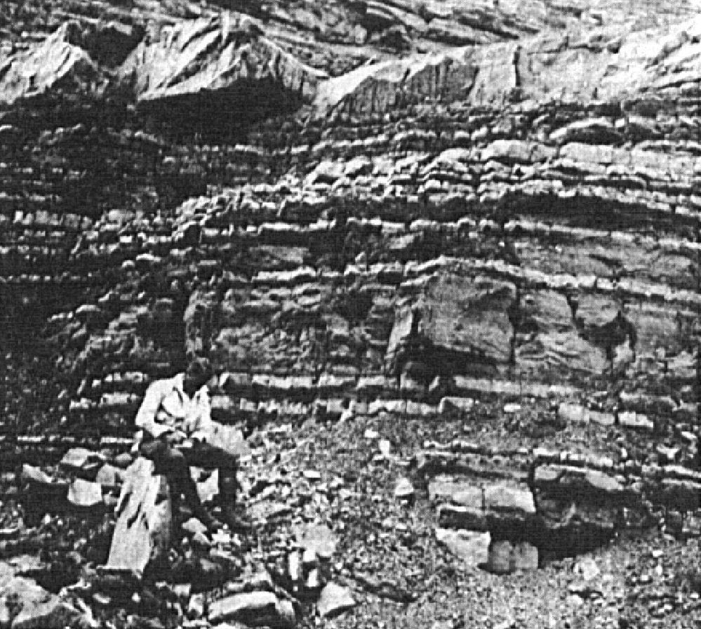
The Rosemont Member consists mainly of limestone with thin shale interbeds (Clark, 1952, 1972; Brun, 1974, 1975; Harland and Pickerill, 1982; Globensky, 1981, 1986, 1987, 1993; Thériault, 2014). It is composed of a wide variety of lithologies (semi-crystalline, micritic or crystalline limestone), but typically of wavy-bedded argillaceous limestone. Its chemical composition indicates that it is slightly dolomitic. The Rosemont Member represents the most fossiliferous unit in the Trenton Group. The type section was described by Clark (1952) at the quarry on the grounds of the Montreal Botanical Garden, near the intersection of Pie IX and Rosemont boulevards:
| Rosemont Member | Top of the quarry. | Thickness |
| Succession of beds of the same type as the underlying 2.6 m. Examined mainly on rock slides. | 2.4 m | |
| Alternating limestone and argillaceous schist beds 2.5 cm thick; Prasopora orientalis, Dalmanella rogata, Sowerbyella sericea | 1.0 m | |
| Alternating limestone and argillaceous schist beds 5-7.5 cm thick; same fossils as above. | 1.4 m | |
| Argillaceous schist and argillaceous limestone; Prasopora very abundant. | 0.2 m | |
| Crystalline limestone with abundance of common fossils from the Trenton. | 0.15 m | |
| Alternating crystalline and argillaceous limestones; Zygospira recurvirostris very abundant. | 0.7 m | |
| Metamorphosed limestone, highly bleached in places, breaks in needles. Broken fossils. | 0.3 m | |
| Sill of basic rocks. | (0.7 m) | |
| Fine-grained crystalline limestone alternating with compact limestone. Recrystallized and bleached by the top 0.3 m sill. Fresh exposures display abundant gasteropods and pelcypods that are almost impossible to remove from the rock. | 1.7 m | |
| Limestone alternating between crystalline, compact and argillaceous types; in thin beds. Frequent argillaceous partings. Argilaceous beds are extremely rich in Prasopora orientalis and crystalline limestone, in Zygospira recurvirostris. Most of Trenton common fossils are found in abundance. | 3.4 m | |
| Total visible thickness | 11.2 m |
From five sections (Miron Ltd. Company Quarry, Montreal; St-Vincent de Paul Quarry, St-Vincent-de-Paul; Sintra Quarry, St-Jacques; Ciments Indépendants Inc. Quarry, Joliette; Turnbull Construction Inc. Quarry, St-Thomas), Brun (1974, 1975) defined boundary stratotypes between the Saint-Michel and Rosemont members, as well as between the Rosemont Member of the Montréal Formation and the Tétreauville Formation: “St-Michel-Rosemont boundary: Gradual transition from alternating large, irregular, beige ‘grainstone’ and dark grey mudstone limestone (St-Michel) to alternating small, regular wavy beds of ‘wackestone’ and dark grey ‘mudstone’ limestone (Rosemont). Rosemont-Tétreauville boundary: Gradual transition from alternating small, regular, undulating beds of ‘wackestone’ and dark grey ‘mudstone’ limestone (Rosemont) to a sequence of large argillaceous ‘mudstone’ limestone beds whose locally poorly defined interbeds prevent good bed differentiation (Tétreauville).”
Thickness and distribution
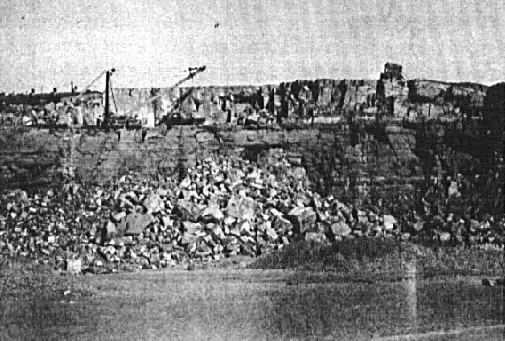
The Rosemont Member outcrops mainly between Joliette and Montreal and the best sections are found at Montreal quarries. Its thickness ranges from 80 to 100 m (Clark and Globensky, 1976a, b; Harland and Pickerill, 1982). The unit is also present in the Saint-Jean-sur-Richelieu area, south of Montreal.
Dating
None.
Stratigraphic Relationship(s)
In the greater Montreal and Joliette area, the Rosemont Member is lying on the Saint-Michel Member and is gradually overlain by the Tétreauville Formation. There is no equivalent of the Rosemont Member east of Trois-Rivières (Globensky, 1987).
Paleontology
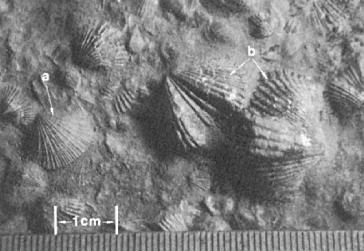
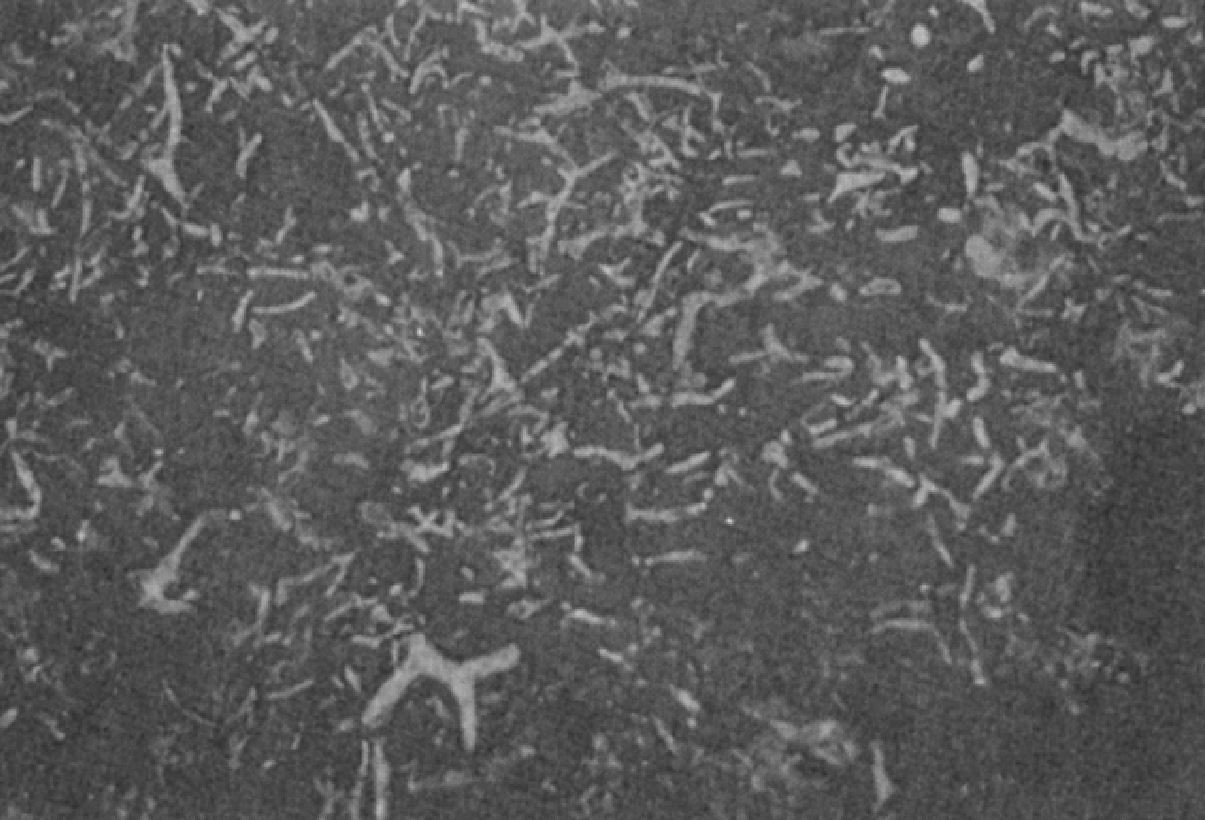
The Rosemont Member represents the most fossil-rich unit in the Trenton Group. Noticeable is the presence of bryozoans Prasopora orientalis and brachiopodes Zygospira recurvirostris in large amounts (Clark, 1952, 1972; Globensky, 1981, 1987).
References
Publications Available Through SIGÉOM Examine
BRUN, J. 1974. ETUDE PETROGRAPHIQUE DES FORMATIONS DU BLACK RIVER ET DU TRENTON DU QUEBEC. MRN. DP 248, 24 pages and 4 plans.
BRUN, J. 1975. ETUDE GEOLOGIQUE ET GEOCHIMIQUE DES FORMATIONS DU BLACK RIVER ET DU TRENTON DU QUEBEC. MRN. DP 296, 45 pages and 4 plans.
CLARK, T H. 1952. MONTREAL AREA, LAVAL AND LACHINE MAPS AREAS. MRN. RG 046(A), 182 pages and 4 plans.
CLARK, T H. 1952. REGION DE MONTREAL, FEUILLES DE LAVAL ET DE LACHINE. MRN. RG 046, 189 pages and 4 plans.
CLARK, T H. 1972. REGION DE MONTREAL. MRN. RG 152, 260 pages and 1 plan.
CLARK, T H., GLOBENSKY, Y. 1975. REGION DE GRONDINES. MRN. RG 154, 171 pages and 1 plan.
CLARK, T H., GLOBENSKY, Y. 1976a. REGION DE SOREL ET PARTIE SUD-EST DE SAINT-GABRIEL-DE-BRANDON. MRN. RG 155, 166 pages and 1 plan.
CLARK, T H., GLOBENSKY, Y. 1976b. REGION DES LAURENTIDES (MOITIE EST) ET DE RAWDON (PARTIE SUD-EST). MRN. RG 157, 121 pages and 1 plan.
CLARK, T H., GLOBENSKY, Y. 1977. REGION DE VERCHERES. MRN. RG 190, 72 pages and 1 plan.
GLOBENSKY, Y. 1981. REGION DE LACOLLE - SAINT-JEAN (S). MRN. RG 197, 210 pages and 2 plans.
GLOBENSKY, Y. 1983. REGION DES LAURENTIDES (SW). MRN. MM 82-01, 42 pages and 1 plan.
GLOBENSKY, Y. 1986. GEOLOGIE DE LA REGION DE SAINT-CHRYSOSTOME ET DE LACHINE (SUD). MRN. MM 84-02, 182 pages and 2 plans.
GLOBENSKY, Y. 1987. GEOLOGIE DES BASSES-TERRES DU SAINT-LAURENT. MRN. MM 85-02, 71 pages and 1 plan.
GLOBENSKY, Y. 1993. LEXIQUE STRATIGRAPHIQUE CANADIEN - VOLUME V-B - REGION DES APPALACHES, DES BASSES-TERRES DU SAINT-LAURENT ET DES ILES DE LA MADELEINE. MRN. DV 91-23, 336 pages.
MRNF 2009a. GEOLOGIE 1/50 000, 31H06 - SAINT-JEAN-SUR-RICHELIEU. In: MRNF. 2010. CARTE(S) GÉOLOGIQUE(S) DU SIGEOM - feuillet 31h. CG SIGEOM31H, 22 plans.
MRNF 2009b. GEOLOGIE 1/50 000, 31H12 - LAVAL. In: MRNF. 2010. CARTE(S) GÉOLOGIQUE(S) DU SIGEOM - feuillet 31h. CG SIGEOM31H, 22 plans.
THERIAULT, R. 2014. GEOLOGIE DES BASSES-TERRES DU SAINT-LAURENT. MERN. DV 2014-05, 1 plan.
Other Publications
CLARK, T.H. 1944. Structure and stratigraphy in the vicinity of Montréal. Transactions of the Royal Society of Canada; third series, volume 38, serie iv.
CLARK, T.H. 1959. Stratigraphy of the Trenton Group, St. Lawrence Lowlands, Quebec. Geological Association of Canada; proceedings 1959, pages 13–21.
HARLAND, T.L., PICKERILL, R.K. 1982. A review of Middle Ordovician sedimentation in the St. Lawrence Lowland, eastern Canada. Geological Journal; volume 17, pages 135–156. https://doi.org/10.1002/gj.3350170205