

 au travail _ Équipe Girardville 2020A")
A")


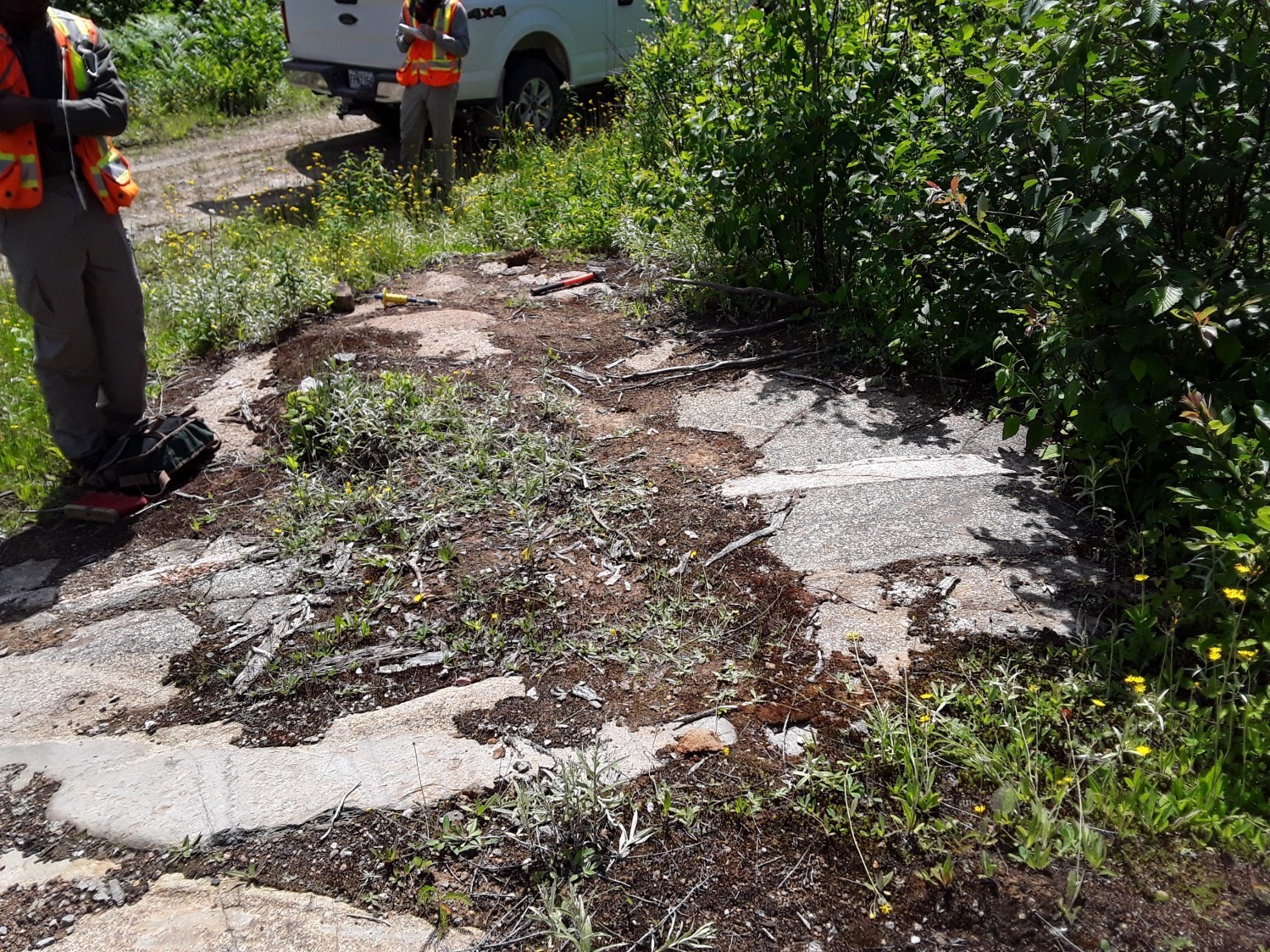
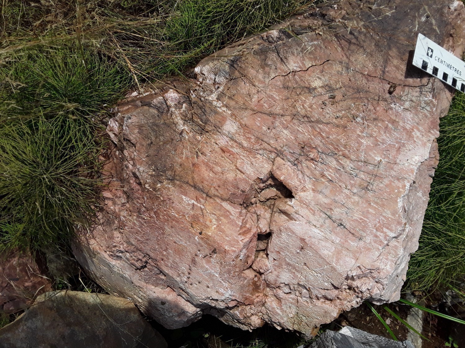
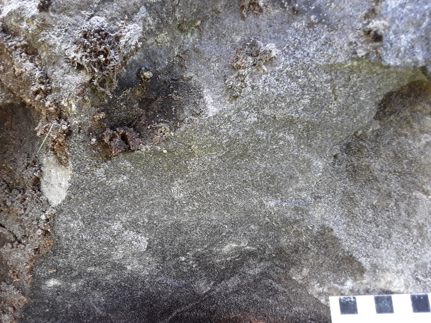
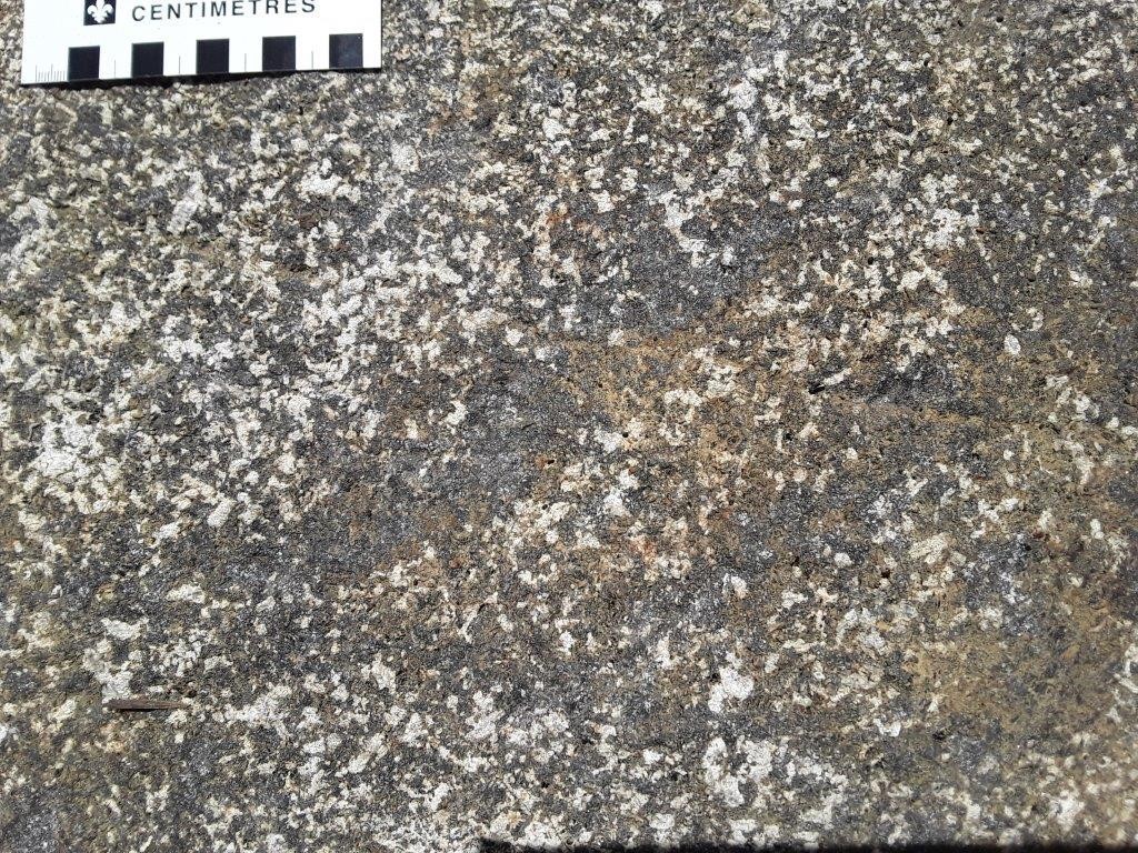
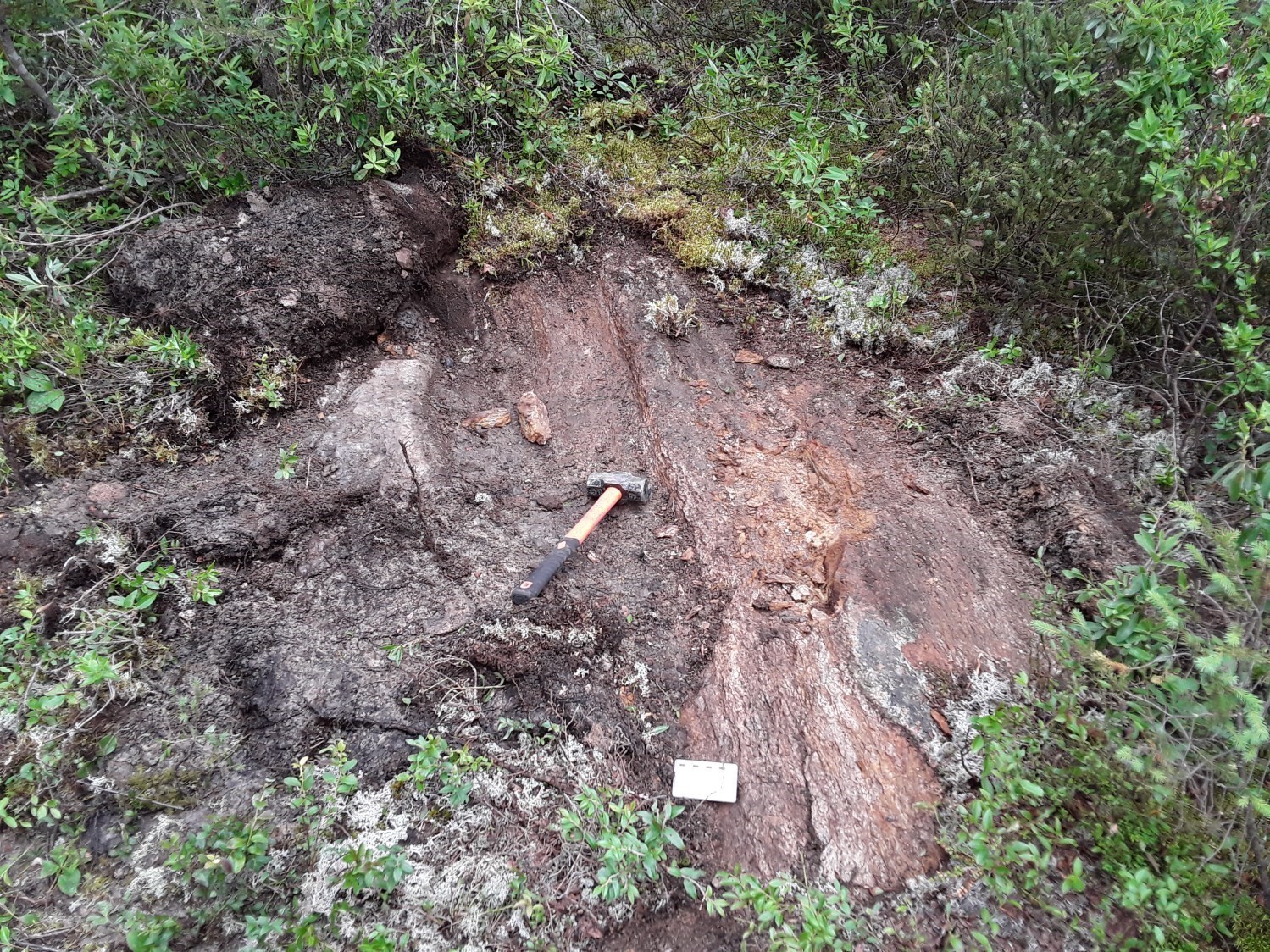
. Affleurement d'une zone de faille (St-François-de-salesA")
A")
 Équipe Girardville 2020 (distenciation 2M-Covid19)_2A")
 Équipe Girardville 2020 (distenciation 2M-Covid19)_1A")
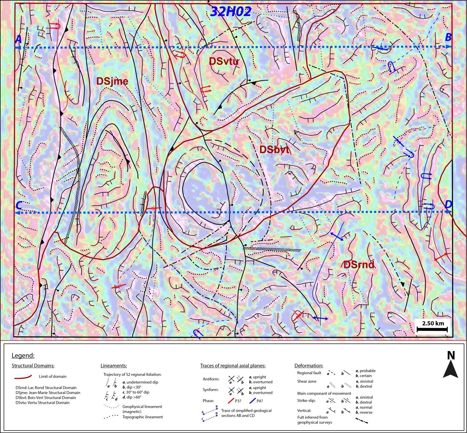
Geology of the Girardville Area, Grenville Province, Saguenay–Lac-Saint-Jean Region, Quebec, Canada
Project for NTS sheet 32H02
Abdelali Moukhsil and Mhamed El Bourki
BG 2021-02
Translated on 8 December 2021


A new 1:50 000 scale geological map of the Girardville area (NTS sheet 32H02) in the Saguenay–Lac-Saint-Jean region was produced following a survey conducted in the summer of 2020. Rocks mapped are mainly Mesoproterozoic in age (0.99-1.45 Ga). Several units recognized in the Normandin area (sheet 32A15) continue northward into the Girardville area. These are the Barrois Complex (metasedimentary rocks, <1224 ±18 Ma), the Allegrin Plutonic Suite (undated), the Saint-Thomas-Didyme Suite (1042 ±2 Ma), the Sainte-Hedwidge Intrusive Suite (1017 ±36 Ma) and the Claire Gabbronorite (undated). New lithodemic units have been mapped as part of this project. These units are the Bois Vert and Vertu plutonic suites, the Coin Batholith and the Bolduc and Jean-Marie intrusive suites. These intrusive units consist mainly of gabbronorite, mangerite, quartz syenite, orthopyroxene quartz syenite, syenogranite, alkali feldspar granite, charnockite and, less commonly, alkali feldspar quartz syenite, jotunite, monzodiorite, leuconorite and pyroxenite. Granitic to syenitic pegmatite dykes cut rocks of the area and a carbonatite dyke intrudes the Sainte-Hedwidge Intrusive Suite. Mapped rocks are generally deformed, folded and cut by several faults and shear zones. The structural pattern is predominantly oriented N-S to NNE-SSW. The area is characterized by amphibolite to granulite facies prograde regional metamorphism. It hosts several types of mineralization providing a significant mineral potential allowing the definition of prospective zones for mining exploration:
- Rare earth element ± Th ± Nb ± Ta mineralization in granitic dykes, alkali feldspar syenitic and intrusive granitic rocks and carbonatite;
- Fe-Ti ± P ± V mineralization in gabbronorite;
- Ni ± Cu mineralization in ultramafic intrusive rocks;
- Industrial minerals (sillimanite) mineralization.
Methodology
The area was mapped using the established method for surveys in forest areas served by a network of secondary roads. The geological mapping was conducted by a team of three geologists, one geologist-in-training and two students in geology between June 28 and August 28, 2020.
| Element | Number |
|---|---|
| Described outcrop (“geofiche”) | 620 outcrops |
| Total lithogeochemical analysis | 85 samples |
| Lithogeochemical analysis of metals of economic interest | 64 samples |
| Geochronological analysis | 7 samples |
| Covered thin section | 83 |
| Polished thin section | 74 |
| Sodium cobaltinitrite stain | 0 |
| Stratigraphic unit | 10 |
| Metallic mineralization record | 5 |
| Nonmetallic mineralization record | 1 |
Previous Work
The table below lists the work that has been done in the study area since 1961. It also includes references cited in the report. An exhaustive list can be found in the EXAMINE documentary database.
| Author(s) | Type of Work | Contribution |
|---|---|---|
| Benoit,1961 | Geological mapping at scale 1:63 360 (sheet 32H02) | Among the few geological maps at this scale in the Grenville Province |
| Laurin and Sharma, 1975 | Geological mapping and reconnaissance at scale 1:250 000 | Mapping project spread over several years (1965-1967) |
| Intissar and Benahmed, 2015 | Airborne magnetic survey of the western part of Lake Saint-Jean | High-resolution geophysical coverage |
| Geological survey of Quaternary deposits in the Girardville area (sheets 32H01, 32H02, 32H07 and 32H08) | Analysis of indicator minerals in glacial and glaciofluvial sediments | |
| Mapping of surface deposits in the Mistassini River area (sheets 32H01, 32H02, 32H07 and 32H08) | Mineral potential assessment from a Quaternary geological survey |
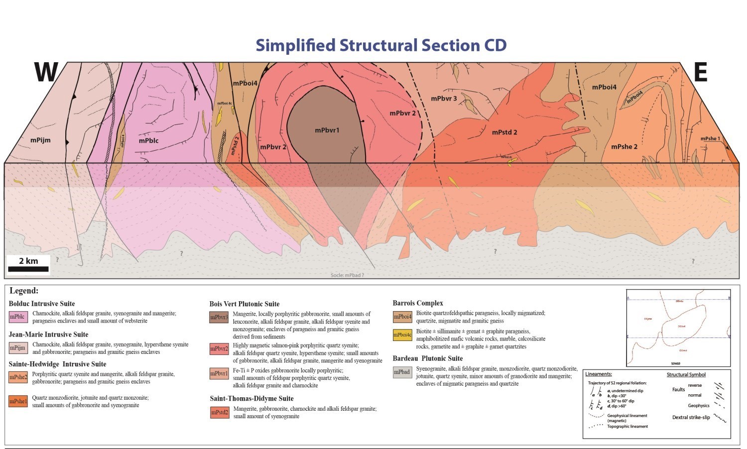
Lithostratigraphy
This section presents the different lithologies of the mapped area in a stratigraphic and temporal perspective. The stratigraphic diagram and timeline below accompany this discussion. The lithological description of units can be consulted from the respective stratigraphic units by using the hyperlink associated with each one.
The Saguenay–Lac-Saint-Jean region mapped is located in the allochton zone of the Grenville Province. This region contains rocks that are mainly Mesoproterozoic in age (0.99-1.45 Ga).
The relative emplacement chronology of these units is illustrated in the stratigraphic diagram, which takes into account crosscutting relationships described in the field. These observations are supported by U-Pb geochronological data from several samples taken in the area. This diagram is a highly idealized section of the geology of the study area illustrating the crosscutting relationships of units as well as their relative positions. The size of units represented in the diagram more or less respects the surface areas that were mapped.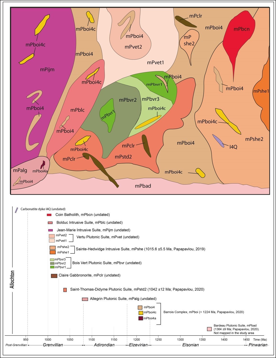
Bedrock
Intrusive Rocks
The Bardeau Plutonic Suite (mPbad) consists of mafic intrusive rocks that are either deformed or gneissic. The suite outcrops in sheet 32A15 (Moukhsil and El Bourki, 2019) where it has been dated 1364 ±9 Ma (Papapavlou, 2020). Although it has not been recognized in the study area, it is considered the basement.
Supracrustal Rocks
The Barrois Complex (mPboi) is the oldest rock package mapped in the study area with a maximum depositional age of 1224 Ma (Papapavlou, 2020). It consists of metasedimentary rocks overlying the Bardeau Plutonic Suite (mPbad). It contains variable proportions of mobilisate. In the mapped area, the Barrois Complex includes the unit consisting of biotite quartzofeldspathic paragneiss, locally migmatized, quartzite, migmatite and granitic gneiss (mPboi4). Only two subunits of the latter are recognized: (a) rusty garnet-sulphide-graphite paragneiss, migmatitic paragneiss, migmatite and granitic gneiss (mPboi4a), and (b) biotite ± sillimanite ± garnet ± graphite paragneiss, amphibolitized mafic volcanic rocks, marble, calcosilicate rocks, garnetite and ± graphite ± garnet quartzite (mPboi4c).
Mesoproterozoic Intrusive Rocks
Metasedimentary rocks of the Barrois Complex are the host of all Mesoproterozoic Grenvillian intrusions (0.986-1.085 Ga). The latter consist of felsic, intermediate and mafic rocks that are well defined on aeromagnetic maps (Intissar and Benahmed, 2015). These intrusions are, from the oldest to the youngest: the Allegrin Plutonic Suite (mPalg) composed of quartz syenite, alkali feldspar granite and gabbronorite; the Saint-Thomas-Didyme Suite (mPstd) composed of mangerite, gabbronorite, charnockite, alkali feldspar granite and quartz diorite; the Claire Gabbronorite (mPclr) formed by kilometric lenticular masses intruding the above-mentioned units; the Bois Vert Plutonic Suite (mPbvr) which is very magnetic and consists of gabbronorite, locally Fe-Ti ± P oxide gabbronorite, quartz syenite, alkali feldspar granite, charnockite, hypersthene syenite, mangerite and quartz syenite; the Sainte-Hedwige Intrusive Suite (mPshe2, 1017.6 ±36 Ma, Papapavlou, 2019) consisting of quartz syenite, mangerite, alkali feldspar granite, gabbronorite and enclaves of paragneiss and granitic gneiss; the Vertu Plutonic Suite (mPvet), also very magnetic and consisting of hypersthene syenite, quartz syenite, alkali feldspar granite and mangerite; the Jean-Marie Intrusive Suite (mPijm) which contains charnockite, alkali feldspar granite, syenogranite, hypersthene syenite, gabbronorite rich in paragneiss enclaves and granitic gneiss; the Bolduc Intrusive Suite (mPblc) consisting of charnockite, alkali feldspar granite, syenogranite, quartz syenite, mangerite containing paragneiss enclaves and minor amounts of websterite; and the Coin Batholith (mPbcn) which is a small intrusion consisting of quartz monzonite, hypersthene quartz monzonite (mangerite), syenogranite, alkali feldspar granite and minor amounts of quartz monzodiorite.
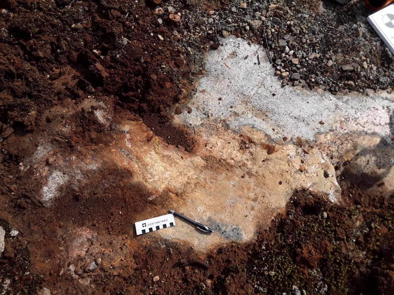
Girardville Carbonatite Dyke
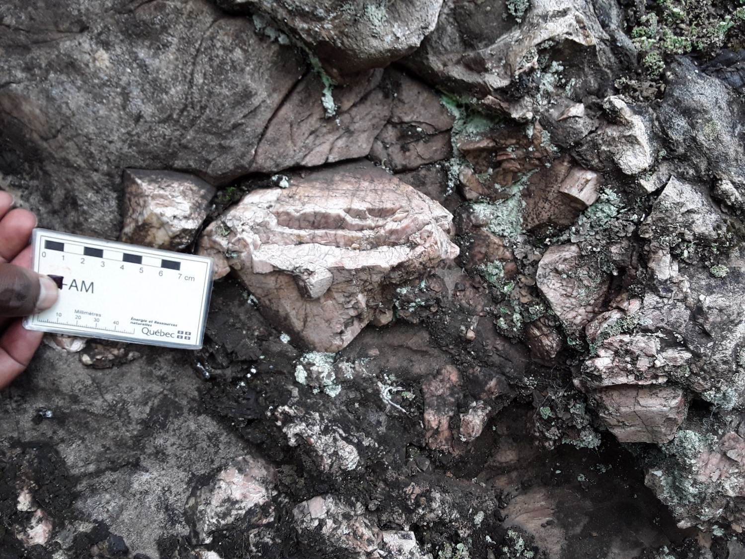
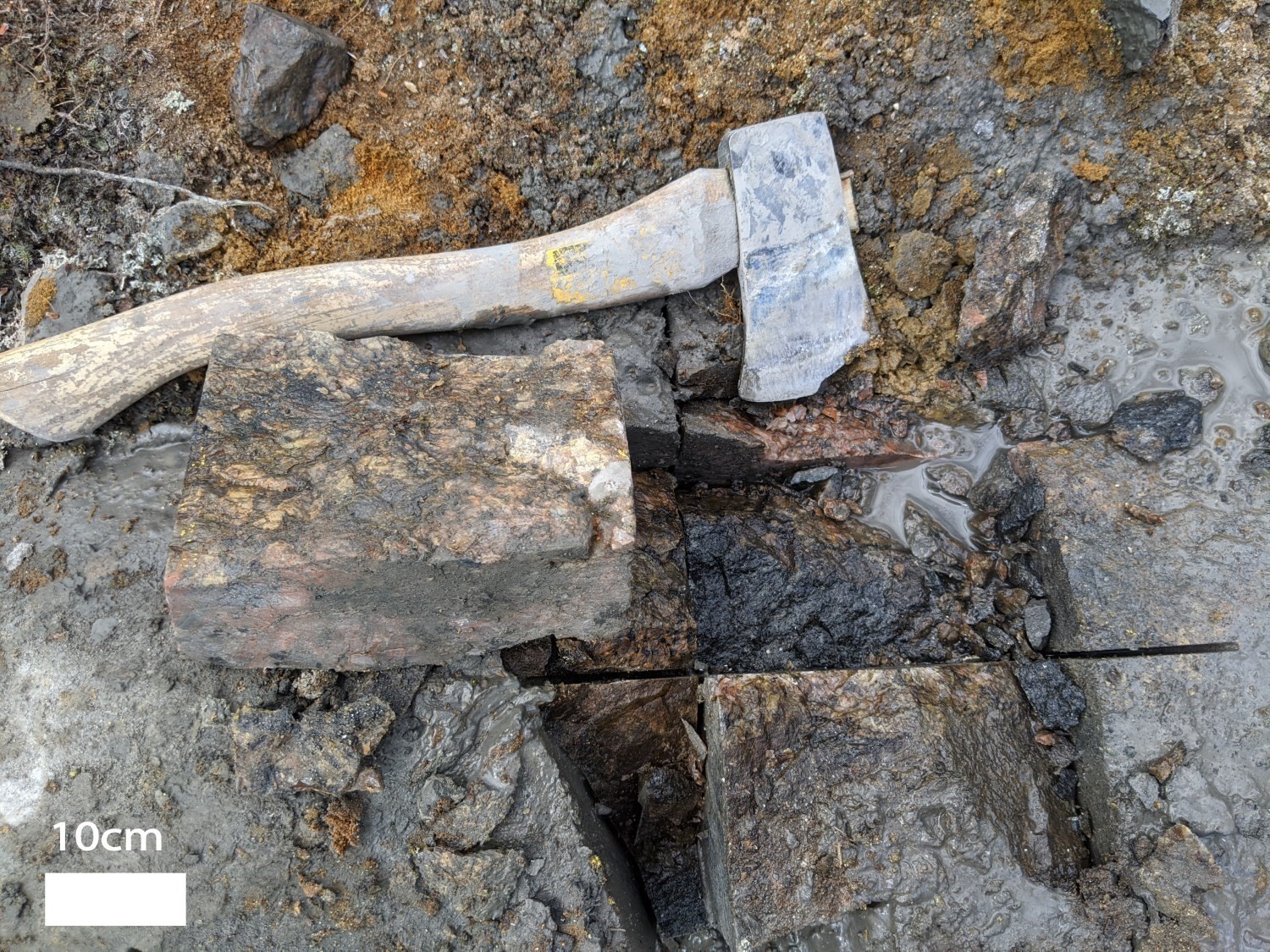
 The Girardville carbonatite is a 1-2 m thick dyke oriented 350°/48°. The dyke outcrops in the SE corner of the area where it intrudes into the Sainte-Hedwidge Intrusive Suite. The carbonatite is composed of calcite, large ilmenite crystals, as well as microcline, phlogopite, aegirine, apatite (concentrated in a millimetric layer) and fluorite. It also contains mafic enclaves. Dupuis and David (2013) reported the presence of pyrochlore, zircon, fluorapatite, rutile, anatase, magnetite and hematite. Moorhead et al. (2000) mention that the carbonatite has not been dated. Furthermore, it is located in the Waswanipi-Saguenay Zone, which includes, among others, the Montviel (1894.2 ±3.5 Ma, David et al., 2006; Goutier, 2006) and Lac Shortt (2652 Ma, Morasse, 1988 in Nadeau et al., 2014) carbonatites in the Superior Province, and the Saint-Honoré carbonatite (582.2 ±1.8 Ma, Néron et al., 2018) in the Grenville Province. A second zone (Nottaway) contains the Dolodau carbonatite (2631 ±8 Ma, Augland et al., 2016; Bédard and Chown, 1992). The Crevier carbonatite (957 ±2.9 Ma, Groulier et al., 2020) is located slightly apart from these two zones. From an age perspective, the Girardville and Saint-Honoré carbonatites can be considered to have been emplaced at the same time.
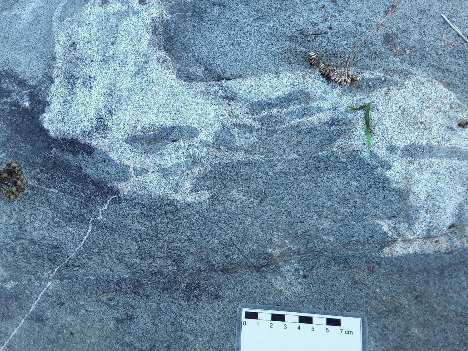
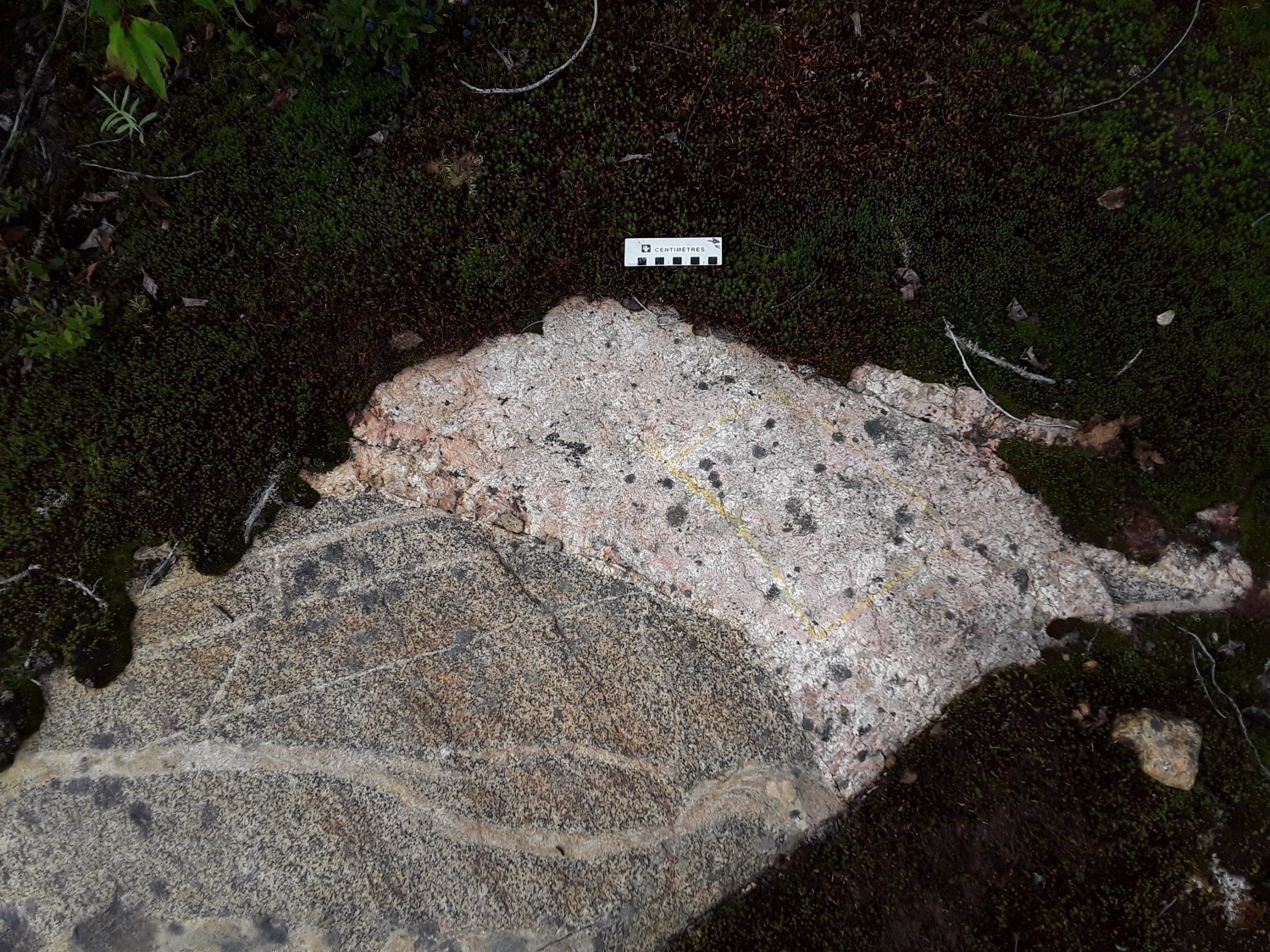
Pegmatitic Dyke Containing Large Microcline Crystal
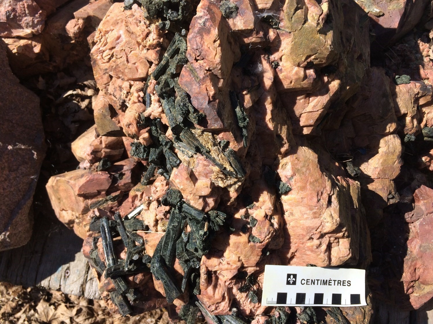
 A spectacular pegmatitic dyke of syenitic composition outcrops 12 km NW of Girardville (Plourde and Tremblay, 2018). This dyke contains:
- large K-feldspar (microcline) crystals – the largest sample exceeds 1 m long according to the owners of the mining claims;
- crystals of a mostly fibrous, greenish mineral (arfvedsonite), ranging in length from 1 cm to 10 cm;
- small aegirine and calcite crystals as wall linings in cavity fillings within the dyke.
The dyke also contains layers of calcic carbonatite a few centimetres to decimetres thick (5-50 cm).
Lithogeochemistry
The lithogeochemistry of units in the Girardville area is presented separately in tabular form.
Structural Geology
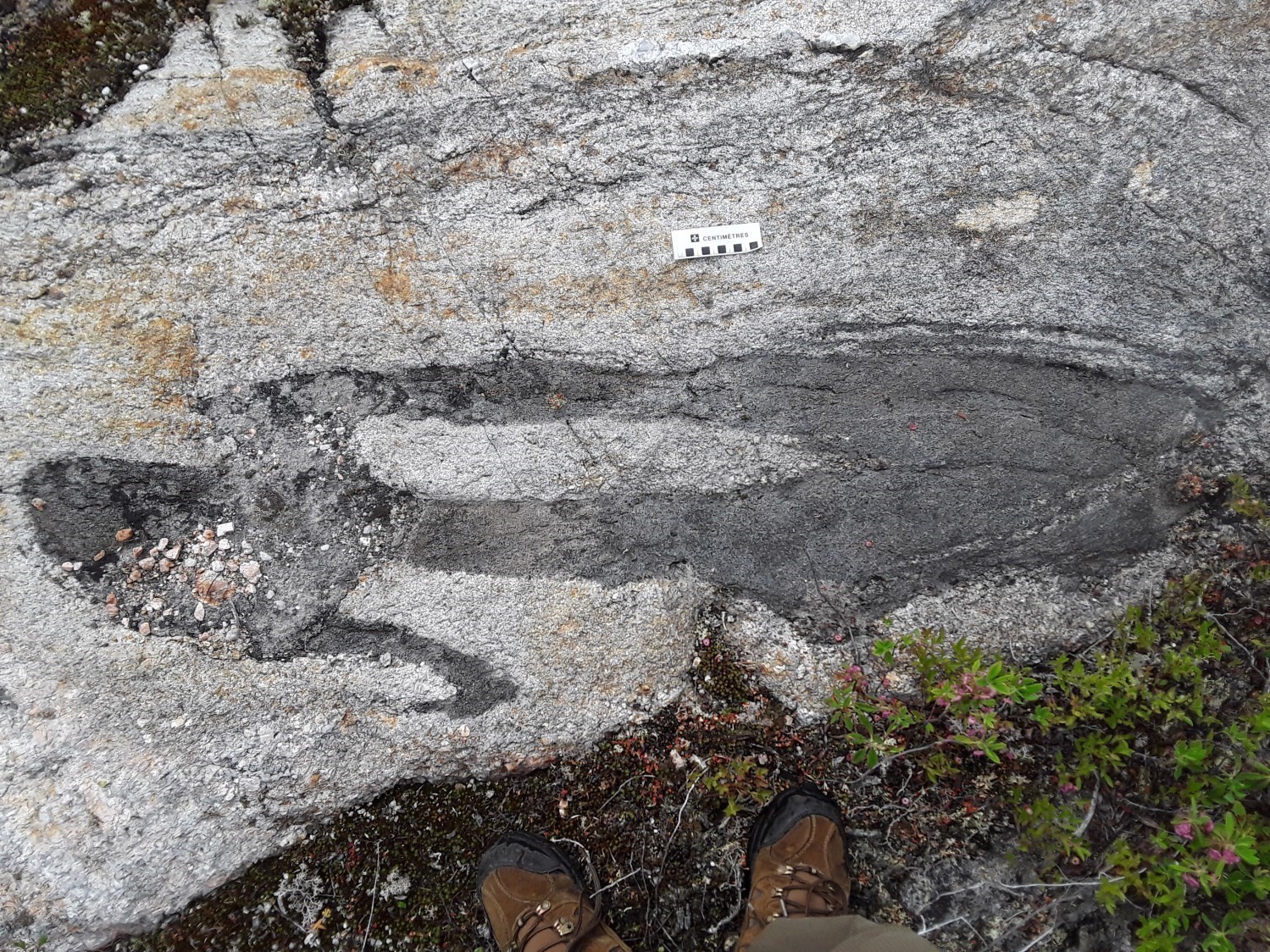
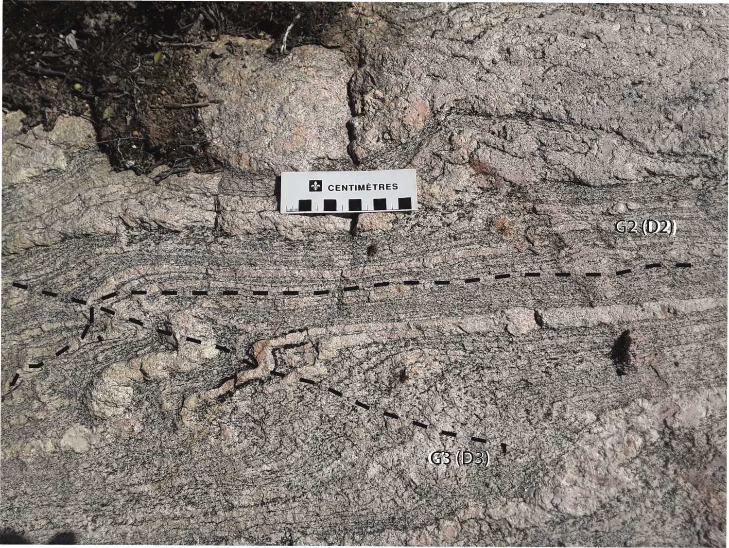 The Elsonian (Bardeau Plutonic Suite) and Elzevirian (Barrois Complex) units are the oldest rocks in the Girardville area. These units have undergone recrystallization, significant deformation and display mostly isoclinal folding (axial planes more or less parallel to the structural grain). These are mainly the result of orogeny and pre-Grenvillian and Grenvillian events (1180-989 Ma). In the mapped area, only the Barrois Complex outcrops; it displays gneissic structures and migmatitic banding that generate regional dome and basin patterns. These planar structures are attributed to D2 deformation. Indeed, primary structures of these units were transposed during an early phase of deformation (D1) and were obliterated by deformation events during the Grenvillian Orogenesis. The end result of the latter is a structural pattern having a main N-S to NNE-SSW orientation. Open folds have been observed in places in rocks of the area and correspond to D3 deformation. The area is also characterized by several faults and shear zones.
Based on the visible and interpreted lineaments pattern of aeromagnetic maps and the attitude of the rocks' planar structures (D2/G2), the Girardville area has been divided into four structural domains. These have generally more or less homogeneous planar structures; they are the Lac Rond (DSrnd), Jean-Marie (DSjme), Vertu (DSvtu) and Bois Vert (DSbvt) structural domains.
The Bois Vert Structural Domain (DSbvt) occupies the centre of the area. It is characterized mainly by the emplacement of the Bois Vert Plutonic Suite. In general, structures within the intrusion are magmatic, whereas those at the edge are characteristic of D2 deformation that follows the elliptical shape of the contact with the host rock. This is a faulted contact well circumscribed from aeromagnetic maps. In stereographic projection, the poles of foliation planes (planar fabric) are predominantly distributed in the NW and SW quadrants (a few points in the other quadrants), resulting in a main N-S to NNE-SSW orientation and a moderate eastward dip. Mineral lineations borne by planar structures are mainly concentrated in the SE quadrant and have a dip to locally oblique component.
The Jean-Marie Structural Domain (DSjme), located in the western part of the map area, exhibits a general N-S oriented structural pattern resulting from the emplacement of the Jean-Marie (mPijm) and Bolduc (mPblc) intrusive suites. These intrusions are also cut or bounded by major faults (normal and reverse) of average N-S orientation and by dextral shear zones. The dominant structural grain in this domain is oriented N-S to NNE-SSW and dips moderately either eastward or westward. It is represented mainly by tectonometamorphic mineral foliation of D2 deformation. Mineral lineations borne by these planar fabrics generally have an oblique, in places directional, component. In stereographic projection, lineations are mainly distributed in the SE quadrant (a few points in the SW quadrant) and correspond to the planes of the west-dipping foliation.
The Vertu Structural Domain (DSvtu) occupies the north-central part of the area and is dominated by the Vertu Plutonic Suite. It exhibits a mean planar fabric oriented NNW-SSE that is generally characterized by tectonometamorphic mineral foliation, magmatic foliation or mylonitic banding. In stereographic projection, the poles of foliation planes largely occupy the SW quadrant. Lineations borne by these planar structures generally have an oblique component. Note that in this domain, there are two normal faults whose orientation is subparallel to the interpreted structural pattern for this domain. It is possible that a relationship exists between the emplacement of this intrusion and these faults. Another fault, which is oriented E-W, has been mapped to the south of the intrusion and is interpreted as a thrust fault. This fault is less documented due to the limited number of outcrops.
The Lac Rond Structural Domain (DSrnd), located in the eastern and southern parts of the mapped area, is the northern continuation of the same domain recognized in sheets 32A15 and 32A16 (Moukhsil and El Bourki, 2019). It comprises mainly the Barrois Complex, the Coin Batholith, the Saint-Thomas-Didyme Suite and the Sainte-Hedwidge Intrusive Suite. The planar fabric of this domain in this area is fairly homogeneous with an average N-S orientation and a moderate eastward dip (mean foliation G2: 354°/39°). In stereographic projection, mineral lineations borne by planar fabrics in the area are distributed in a circle around the mean foliation vector and vary from a lineation having a dip to directional components.
In order to illustrate the relationships between the different lithostratigraphic units in the Girardville area, two geological sections, namely AB and CD, were made in an E-W orientation.

Metamorphism
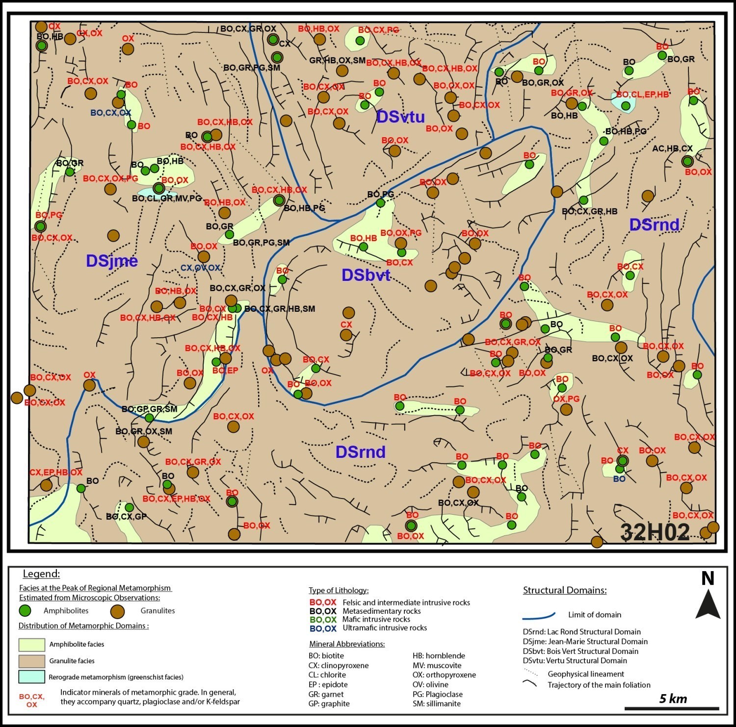
The study of the metamorphic evolution of the Girardville area was based on mineralogical and structural observations at the macroscopic and microscopic scales (157 thin and polished sections of representative samples of Mesoproterozoic units). It indicates that rocks of the area show a lot of evidence for amphibolite and granulite facies prograde metamorphism (simplified metamorphic map).
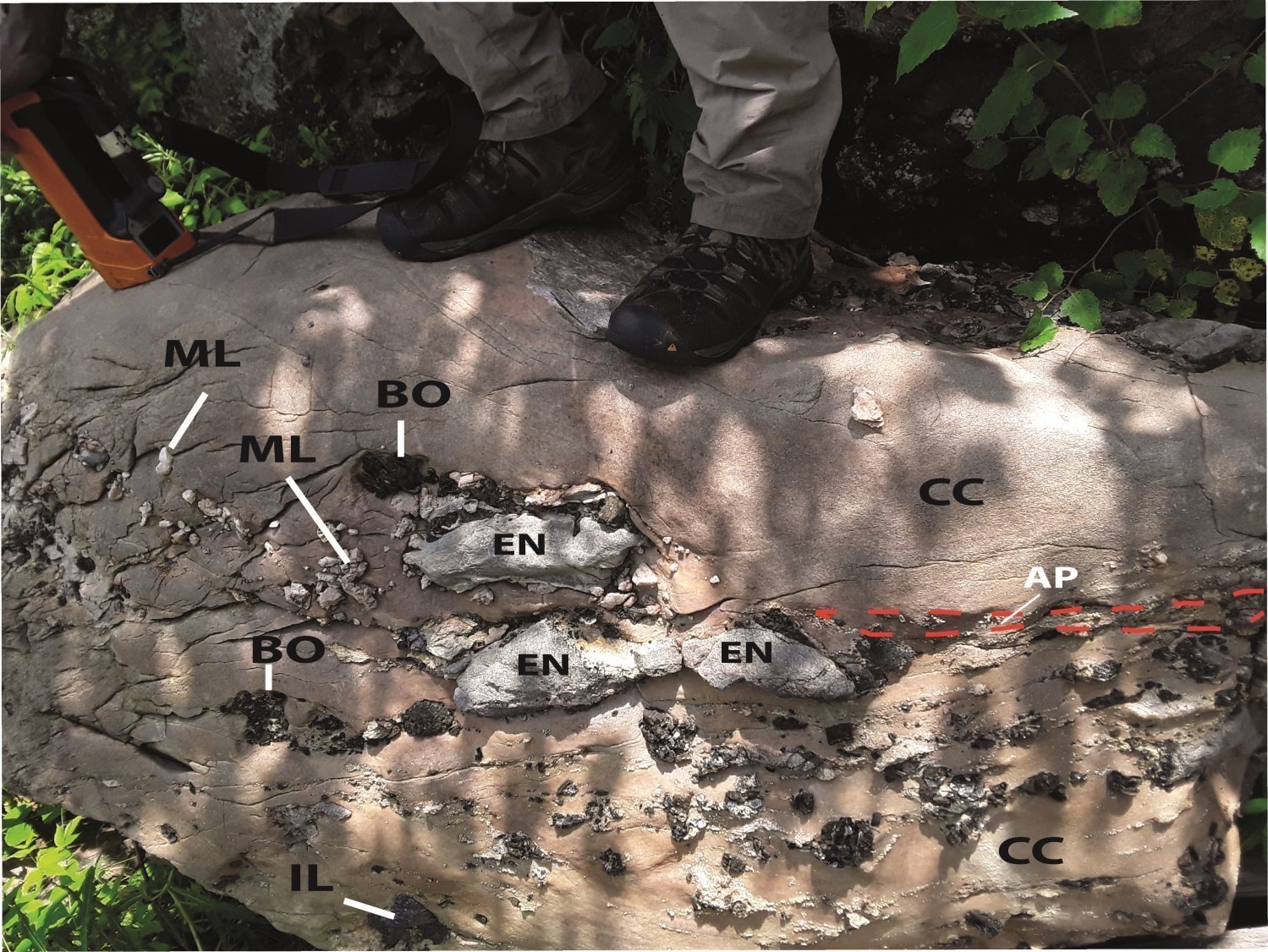
The Barrois Complex rocks, which include aluminous paragneiss (metapelite), contain biotite (BO), sillimanite (SM) and garnet (GR) parageneses indicating that this unit has been metamorphosed to the upper amphibolite facies. This complex also contains subunits of migmatitic rocks having undergone different degrees of partial melting.
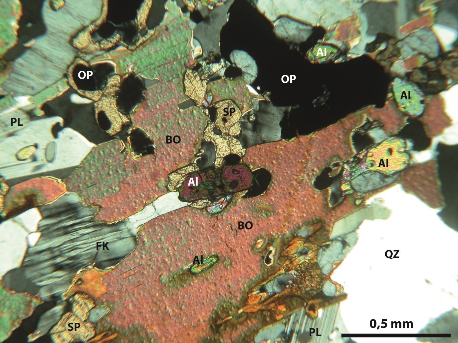
Similarly, orthopyroxene is ubiquitous in most rocks of the area at both macroscopic and microscopic (thin section) scales for several felsic, intermediate and mafic intrusions (e.g. outcrop 20-FM-2115). This indicates that these rocks were emplaced under temperature and pressure conditions equivalent to those of the granulite facies. The presence of perthitc and mesoperthitic textures (albite inclusions) in K-feldspar of felsic and intermediate intrusive rocks is also indicative of high-temperature conditions.
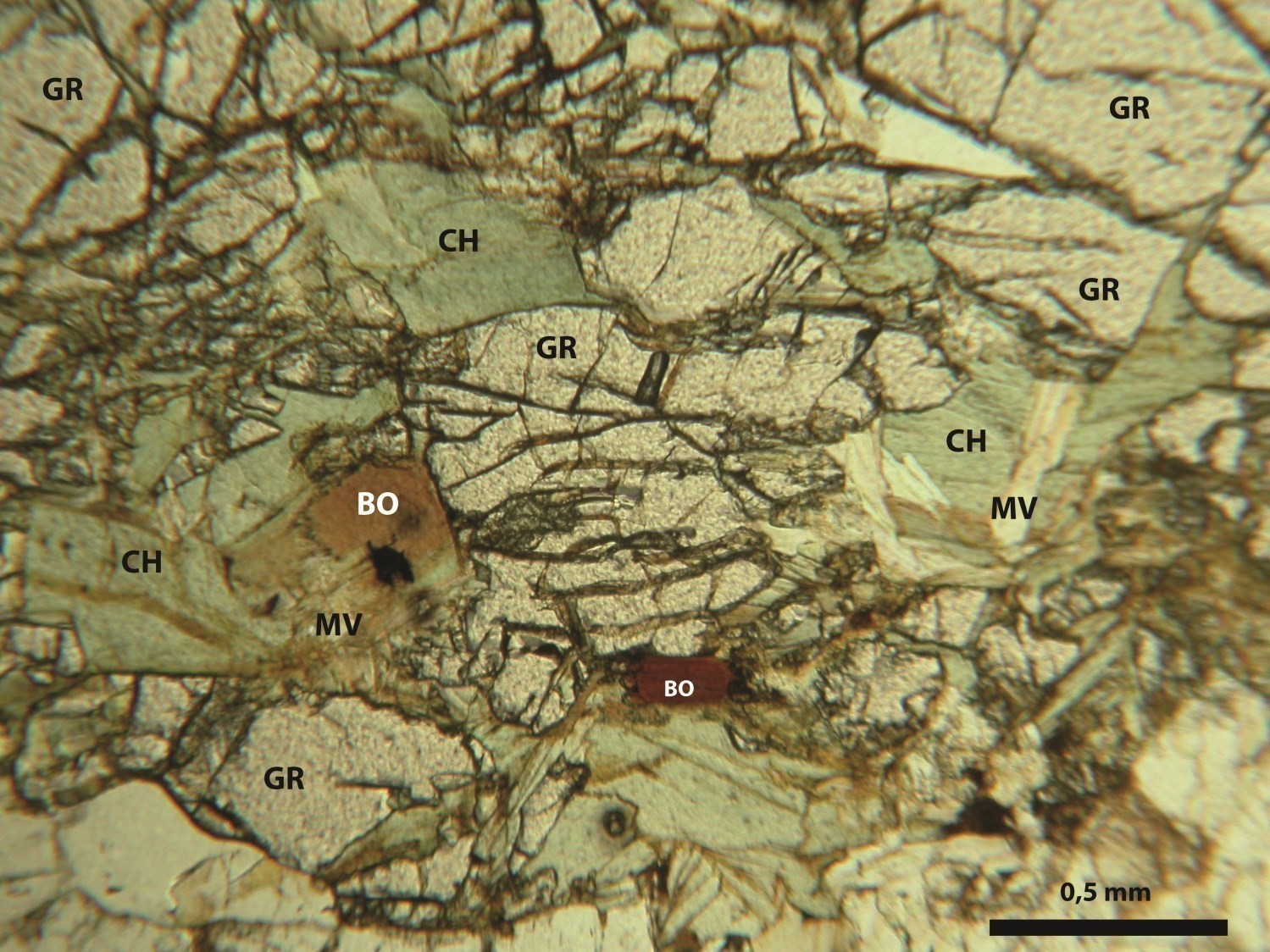
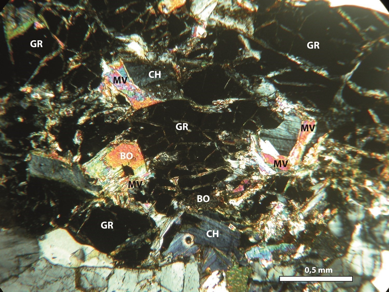 Rocks of the area also suggest lower amphibolite facies retrograde metamorphism. This is indicated by partial or total replacement of pyroxene by amphibole (uralitization). Locally, a low-grade metamorphic association has been observed in paragneiss. Garnet is associated with a biotite-chlorite-muscovite assemblage indicative of a greenschist facies metamorphism, among others, by the transformation of biotite in chlorite or partly in muscovite (outcrop 20-ME-1038).
Economic Geology
The Girardville area has several prospective zones for four types of mineralization:
- Rare earth element ± Th ± Nb ± Ta mineralization associated with granitic pegmatitic dykes, syenitic intrusive rocks, a carbonatite dyke and alkali feldspar granites;
- Magmatic Fe-Ti (± P ± V) mineralization in gabbronorites;
- Magmatic Cu-Ni mineralization in ultramafic intrusive rocks;
- Mineralization of industrial minerals (sillimanite).
The table of mineralized zones below presents the analytical results for five known mineralization zones in the area (sheet 32H02), including three new zones of metallic substances discovered in the course of our work.
| Name | Contents | Comments |
|---|---|---|
| Mineralization Associated with Granitic Pegmatites | ||
| ETRALI | 4827.88 ppm REE (G); 1230 ppm Th (G); 20.4 ppm Nb (G) | |
| Jeb | 10 561.01 ppm REE (G) | |
| Niobithor | 551 ppm Nb (G); 732 ppm Th (G); 257 ppm Y (G); 1100 ppm Zr (G); 9.8 ppm Ta (G) | |
| Mineralization of Undetermined Type | ||
| Beaudet | 1861.25 ppm REE (G) | |
| Name | Contents | Comments |
|---|---|---|
| Mineralization Associated with Carbonatites | ||
| Carbonatite de Girardville | 37 000 ppm Nb (G); 25 780 ppm Ti (G) | |
| Guérin-Plourde | Agglomerations of K-feldspar or aegirine megacrystals are found within cavities. Calcite is found as small crystals or clusters. | |
(G): Selected sample
The table of lithogeochemical analyses of metals of economic interest presents the location, description and analytical results for 64 selected samples in order to assess the economic potential of the area.
Known Mineralization in the Study Area
Girardville Prospective Zone
The Girardville prospective zone corresponds to a NNW-SSE corridor featuring enrichment in niobium-tantalum (Nb-Ta) and rare earth elements (REE). The southern part of the corridor contains the Girardville carbonatite dyke (Carbonatite de Girardville mineralized zone), oriented 350°/48°, which is 1 m to 2 m thick (outcrop 20-AM-0129). This carbonatite intrudes syenogranite of the Sainte-Hedwidge Intrusive Suite. A selected sample (20-AM-0129-C1) yielded 1539.59 ppm total REE (including 675 ppm Ce, 318 ppm La and 289 ppm Nd). The northern part of the corridor is characterized by a syenitic pegmatite dyke (Guérin-Plourde mineralized zone) hosted in granitic gneiss (outcrop 20-ME-1097). It contains K-feldspar megacrysts (microcline), grains of an acicular mineral (arfvedsonite), calcite and aegirine crystals, as well as layers of calcitic carbonatite that are 5 cm to 50 cm thick.
Unknown Mineralization Discovered During the Present Work
Two New Rare Earth Element Mineralized Zones
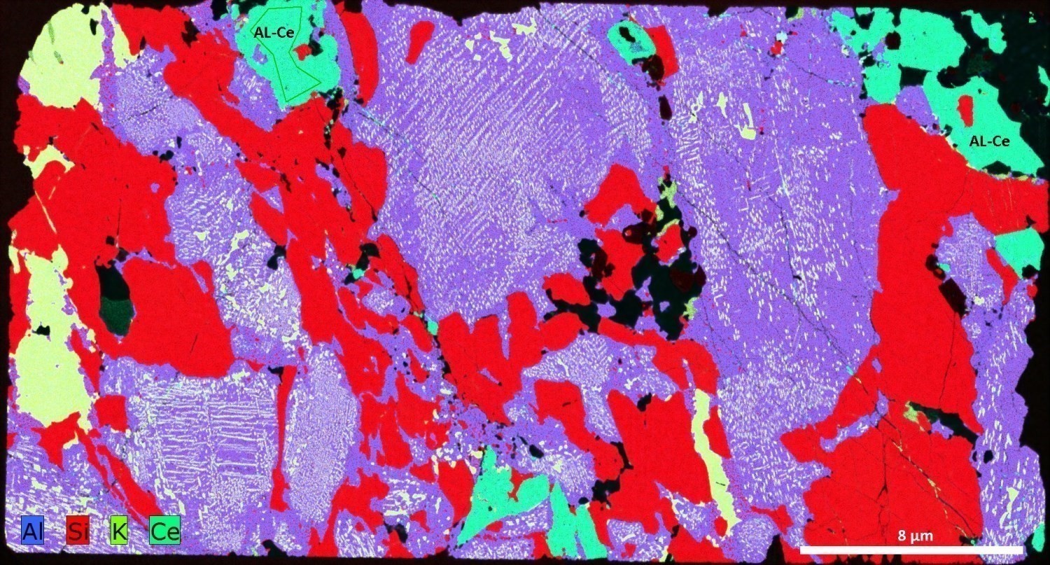
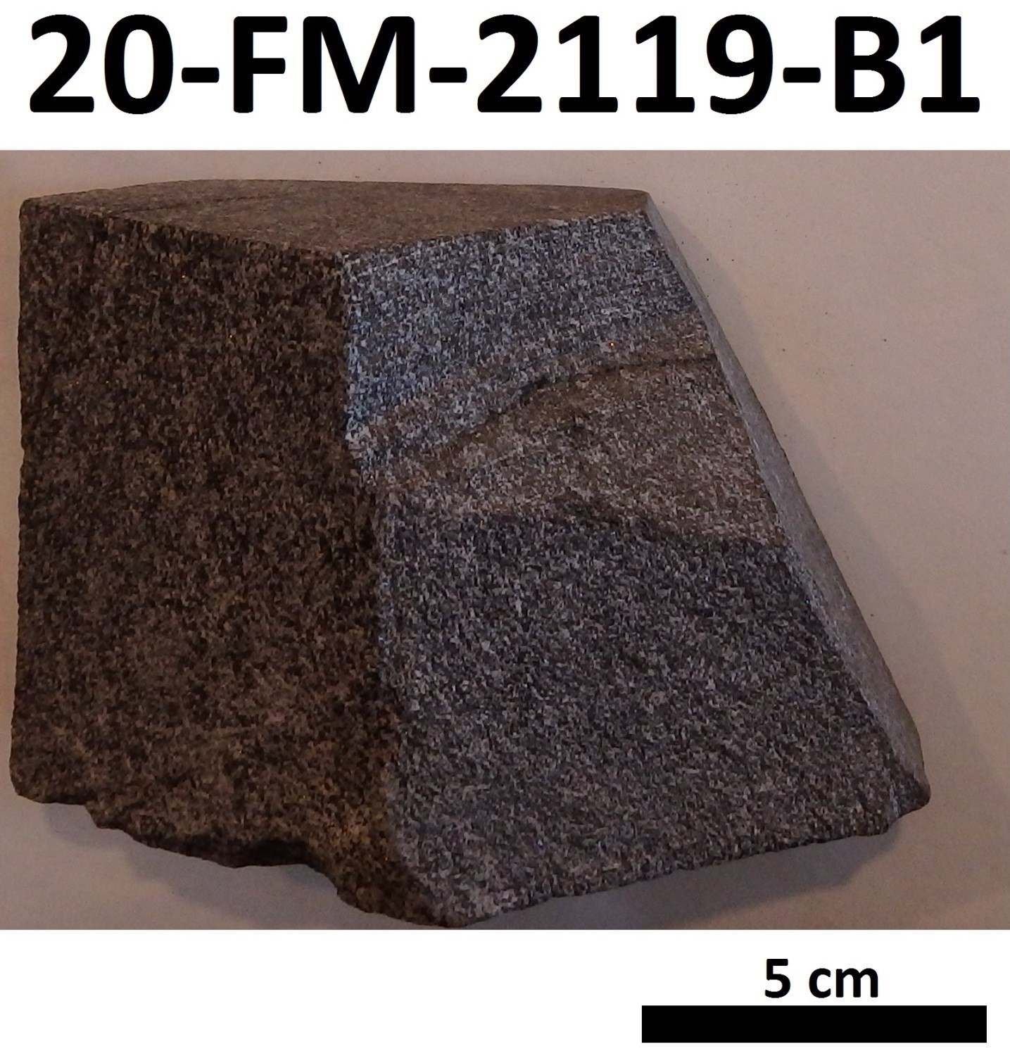 The new Beaudet mineralized zone is located at outcrop 20-FM-2119, approximately 3.2 km NE of the town of Girardville and 3.6 km SE of the known Carbonatite de Girardville mineralized zone. The mineralization is probably allanite bearing and is associated with a grey syenite dyke oriented 110°/85°. The rock is composed of orthopyroxene, clinopyroxene, apatite and biotite. This dyke cuts greenish magnetite-biotite-pyroxene syenite. A selected sample (20-FM-2119-B1) yielded 1861.25 ppm total REE (including 835 ppm Ce, 382 ppm La and 400 ppm Nd).
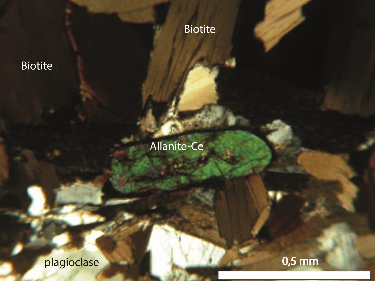
 The new Jeb mineralized zone is located ~800 m east of Roches Lake (NW part of sheet 32H02). It is found at outcrop 20-ME-1087. Mineralization is associated with a syenitic pegmatite dyke oriented 07°/49° and is 5 to 20 cm thick. The pegmatite contains quartz, K-feldspar, biotite, magnetite, allanite and some traces of thorite. This intrusion cuts foliated gabbronorite of the Jean-Marie Intrusive Suite which is composed mainly of orthopyroxene, clinopyroxene, magnetite, amphibole and biotite. Analysis of a selected sample (20-ME-1087-C1) yielded a total REE content of 10 561.01 ppm (including 5320 ppm Ce, 2710 ppm La, 1660 ppm Nd and 544 ppm Pr).
New Prospective Zones for Magmatic REE ± Th ± Nb Mineralization Associated with Granitic Pegmatite Dykes, Syenites and Alkali Feldspar Granites
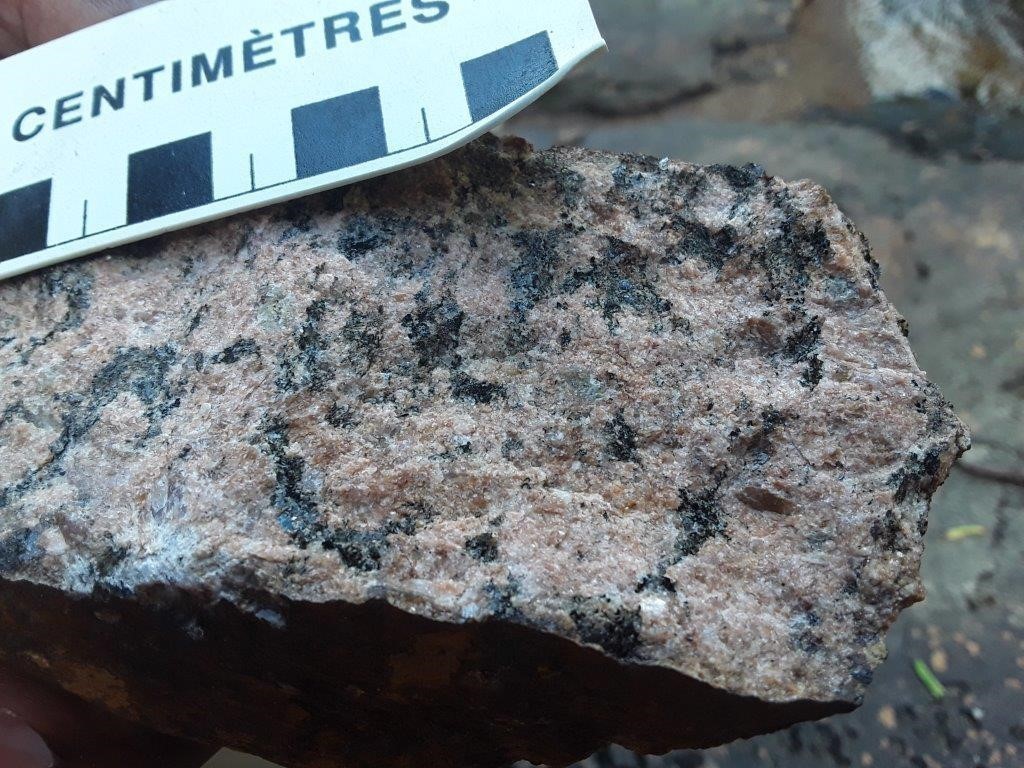
 The ETRALI prospective zone (ETRALI mineralized zone) consists of a pegmatite dyke that cuts migmatite derived from sedimentary rocks. The dyke is oriented 290°/80° and has a thickness of 5 cm to 15 cm and a minimum length of 5 m. It has a granitic composition, metaluminous (15.5% Al2O3) and enriched in potassium (5.81% K2O). It contains biotite, magnetite, allanite, monazite and thorite. A selected sample (20-AM-0041-B1) has contents of 4827.88 ppm total REE (including 2170 ppm Ce, 1020 ppm Nd and 1030 ppm La) and 1230 ppm Th. This sample also yielded 20.4 ppm Nb and 86 ppm Pb.

 The Petit prospective zone is located ~490 m west of Petit Lake, in the Bois Vert Plutonic Suite. The outcrop corresponding to this zone consists of highly magnetic, foliated (120°/57°), medium to coarse-grained quartz syenite. A selected sample (20-AM-0012-A1) contains 1479.18 ppm total REE (including 708 ppm Ce, 328 ppm La and 274 ppm Nd) and 31.2 ppm Nb.
 The Donat prospective zone consists of a medium-grained hornblende-biotite-magnetite syenogranite dyke that intrudes the Barrois Complex (mPboi4). A selected sample (20-ME-1024-A1) yielded contents of 881.13 ppm total REE (including 423 ppm Ce and 236 ppm La).
New Prospective Zone for Fe-Ti (± P ± V) Mineralization Associated with Gabbronorites

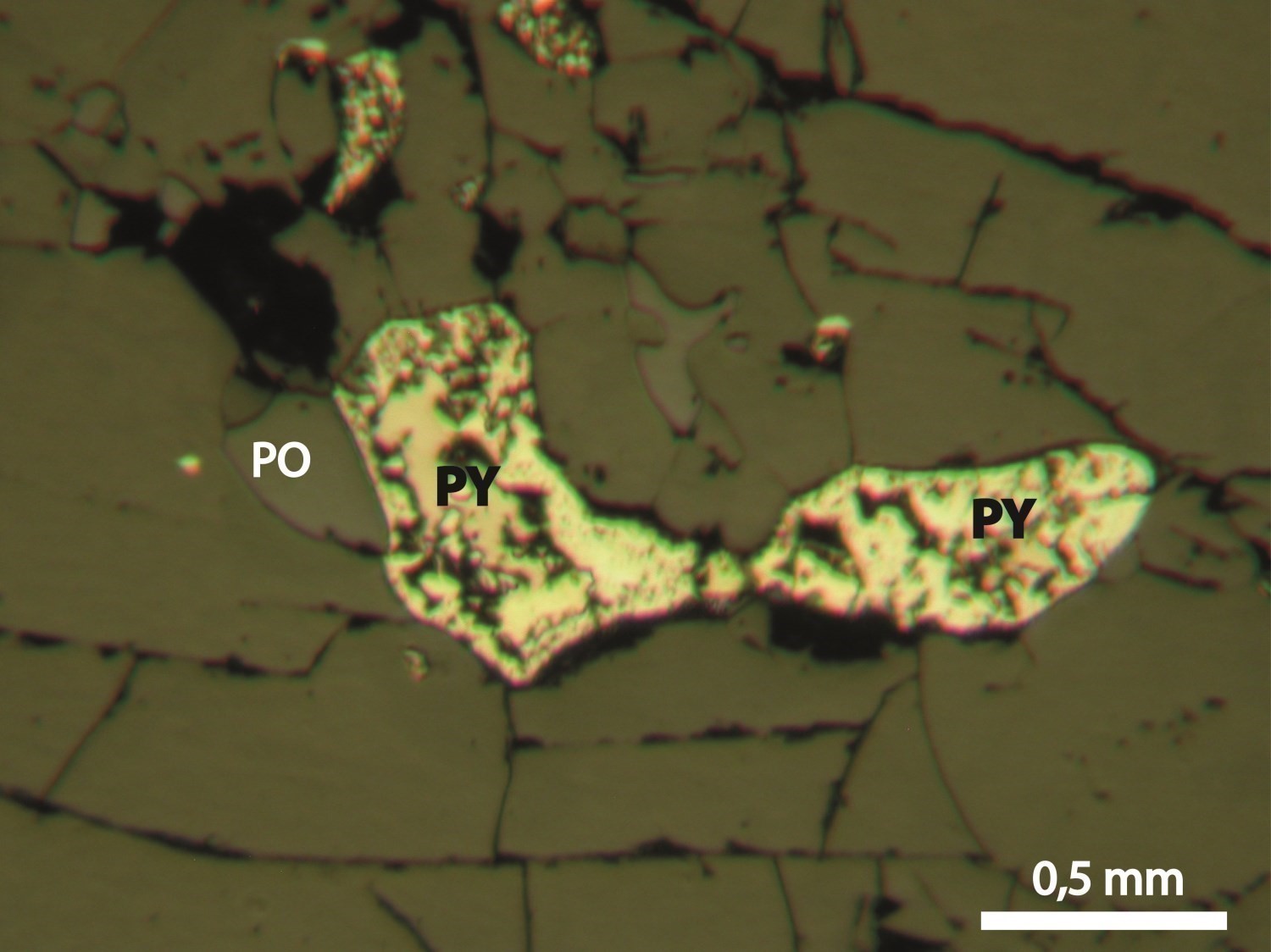
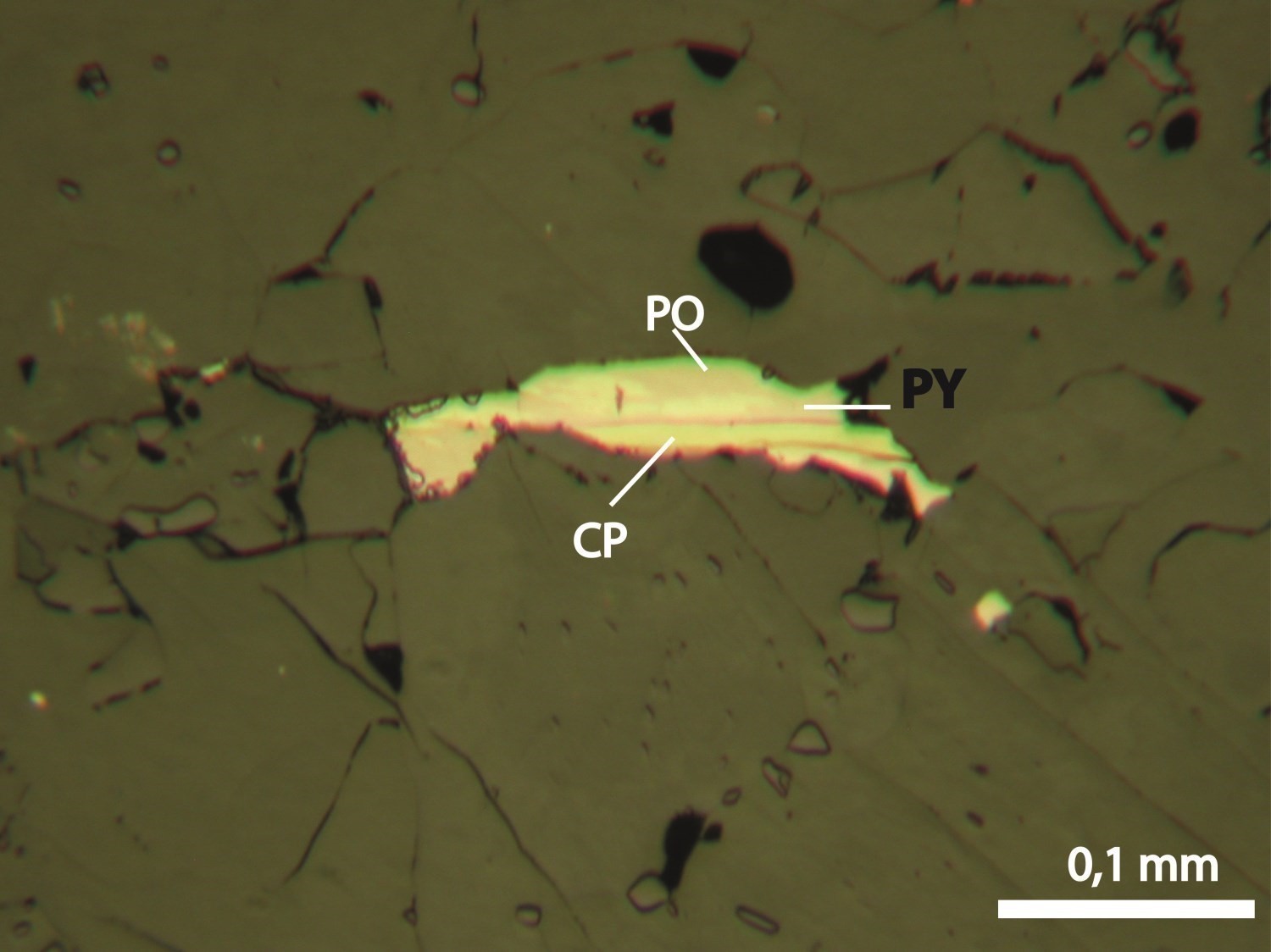
 The Croche prospective zone, located ~480 m west of Croche Lake, consists of gabbronorite. Outcrop 20-AM-0003-A consists of fine to medium-grained leucocratic gabbronorite composed of titano-magnetite, hemo-ilmenite, biotite and orthopyroxene with disseminated pyrrhotite and pyrite (<1%). Outcrop 20-AM-0005 consists of ophitic gabbronorite characterized by clusters (2-3 cm) of hemo-ilmenite, ilmenite and magnetite associated with apatite and traces of pyrite and pyrrhotite. Two selected samples yielded 3.68% TiO2, 1.33% P2O5 and 8.74% Fe (20-AM-0003-A), and 4.15% TiO2, 1.74% P2O5 and 11.1% Fe (20-AM-0005-A). Sample 20-AM-0005-A1 also contains 51.8 ppm Nb and 216 ppm Zn.

 The Pierre prospective zone consists mainly of mafic rocks (gabbronorite) with granite, monzogranite and syenite intrusions (20-FT-3040, 20-FT-3041 and 20-FT-3045) of the Bois Vert Plutonic Suite (mPbvr3). Minerals observed in gabbronorite are clinopyroxene, orthopyroxene, magnetite, hemo-ilmenite and biotite associated with ~1-2% disseminated millimetric sulphide (pyrite, pyrrhotite and chalcopyrite) grains. Three selected samples yielded 4.31% TiO2, 1.96% P2O5, 10.6% Fe and 184 ppm Zn (20-FT-3040-A1), 3.64% TiO2, 2.16% P2O5, 10% Fe and 197 ppm Zn (20-FT-3041-A1), and 3.03% TiO2, 1.92% P2O5, 9.18% Fe and 151 ppm Zn (20-FT-3045-A1).
New Prospective Zone for Ni ± Cu Mineralization in Ultramafic Intrusive Rocks
 The Jumeau Nord prospective zone is located ~750 m NW of Jumeau Nord Lake. It corresponds to outcrop 20-AM-0055, which is characterized by olivine-pyroxene (orthopyroxene and clinopyroxene) websterite (Bolduc Intrusive Suite, mPblc) containing ~2% pyrite and pyrrhotite as disseminated millimetric grains. It also contains traces of chalcopyrite and pentlandite associated with pyrrhotite (<20 μm grains). Websterite makes up 80% of the outcrop; it is associated with charnockite (20% of the outcrop). Analysis of a selected sample (20-AM-0055-A1) yielded contents of 496 ppm Ni, 71 ppm Cu, 99 ppm Co, 0.18% Cr and 52 ppm Zn.
Prospective Zones for Industrial Minerals (Sillimanite)

The Francis prospective zone is associated with two small lenses of paragneiss of the Barrois Complex (mPboi4c). Locally, these paragneiss may contain up to 30% millimetric to centimetric fibrous sillimanite being concentrated in ~1 m thick by 3 m long layers. At outcrop 20-FT-3154, this sillimanite-garnet metasedimentary rock is associated with an impure quartzite bed and thin garnetite layers (40% garnet). This prospective zone is also characterized by a weak magnetic anomaly.
Issues for Future Work
The new 1:50 000 scale geological map has greatly improved the geological knowledge of the Girardville area in terms of stratigraphic, structural and metallogenic descriptions. However, a few issues remain to be addressed: 1) the increase in Nb content from south to north in the mapped area, and 2) the source of the anomalous Zn content in lake bottom sediments.
1) Nb issue: The presence of the Girardville carbonatite and the Guérin-Plourde dyke explains the increase in Nb content in these post-Grenvillian intrusions; on the other hand, the Nb enrichment in Grenvillian syenitic intrusions is not yet explained.
2) Zn issue: The northward continuity of the Moncou prospective zone discovered in an earlier mapping project in the Normandin area (Moukhsil and El Bourki, 2020) has not been confirmed in the Girardville area. It is possible that zinc-enriched rocks are not significant in terms of volume. Instead, they are limited to subunit mPboi4c of the Barrois Complex. The latter easily erodes (marble and aluminous paragneiss) and does not outcrop much in the area.
The Ministère's next geological survey planned to the north of the studied area (sheet 32H07) might be able to explain the increase in Nb contents in Grenvillian rocks. As for zinc contents, they could be explained in the Dolbeau-Mistassini area (sheet 32H01).
| Authors | Abdelali Moukhsil, P.Geo., Ph.D. abdelali.moukhsil@mern.gouv.qc.ca Mhamed El Bourki, GIT, M.Sc. mhamed.elbourki@mern.gouv.qc.ca |
| Geochemistry | Fabien Solgadi, P.Geo., Ph.D. |
| Geophysics |
Rachid Intissar, P.Geo., M.Sc. |
| Potential assessment | Virginie Daubois, P.Geo., M.Sc. |
| Logistics | Marie-Dussault, coordinator |
| Geomatics | Sylvie Tétreault Kathleen O'Brien |
| Template and content compliance | François Leclerc, P.Geo., Ph.D. |
| Coaching/mentoring and critical review | Fabien Solgadi, P.Geo., Ph.D. |
| English version | Céline Dupuis, P.Geo., Ph.D. |
| Organization | General Direction of Géologie Québec, Ministère de l'Énergie et des Ressources naturelles, Government of Québec |
Acknowledgements:
This Geological Bulletin was made possible through the cooperation of many people who have been actively involved in the various stages of the project. We would like to thank geologists Frédéric Massei and Francis Talla Takam, as well as students Sébastien Larente-Marcotte and Johnatan Sylvain-Bravo who performed very well during their internship.
References
Publications of the Government of Québec
AUGLAND, L E., DAVID, J., PILOTE, P., LECLERC, F., GOUTIER, J., HAMMOUCHE, H., LAFRANCE, I., TALLA TAKAM, F., DESCHENES, P.-L., GUEMACHE, M.A., 2016. Datations U-Pb dans les provinces de Churchill et du Supérieur effectuées au GEOTOP en 2012-2013. MERN, GEOTOP. RP 2015-01, 43 pages.
BENOÎT, F.-W., 1961. Rapport préliminaire sur la région de Condé, comté de Roberval. MRN. RP 463, 13 pages and 1 plan.
DAVID, J., DION, C., GOUTIER, J., ROY, P., BANDYAYERA, D., LEGAULT, M., RHEAUME, P., 2006. Datations U-Pb effectuées dans la Sous-province de l'Abitibi à la suite des travaux de 2004-2005. MRNF, GEOTOP UQAM-MCGILL. RP 2006-04, 22 pages.
EL AMRANI, M., 2020. Évaluation du potentiel minéral à partir d'un levé géologique du Quaternaire dans la partie SE de la rivière Mistassini (SNRC 32H01, 32H02, 32H07 et 32H08). MERN; ET 2020-02, 14 pages.
EL AMRANI, M., FOURNIER, N., 2020. Analyse des minéraux indicateurs des sédiments glaciaires et fluvioglaciaires de la partie SE de la région de la rivière Mistassini. MERN, IOS SERVICES GEOSCIENTIFIQUES INC; DP 2019-04, 382 pages.
GOUTIER, J., 2006. Géologie de la région du lac au Goéland (32/F15). MRNF. RG 2005-05, 44 pages and 4 plans.
INTISSAR, R., BENAHMED, S., 2015. Levé magnétique aéroporté dans le secteur ouest du Lac-St-Jean, Province de Grenville. MERN, GOLDAK AIRBORNE SURVEYS. DP 2015-06, 7 pages and 2 plans.
LAURIN, A F., SHARMA, K N M., 1975. Région des rivières Mistassini, Péribonca, Saguenay (Grenville 1965-1967). MRN; RG 161, 103 pages, 10 plans.
MOORHEAD, J., PERREAULT, S., BERCLAZ, A., SHARMA, K N M., BEAUMIER, M., CADIEUX, A.-M., 2000. Kimberlites et diamants dans le nord du Québec. MRN. PRO 2000-05, 10 pages.
MOUKHSIL, A., EL BOURKI, M., 2019. Géologie de la région de Normandin, Province de Grenville, région du Saguenay–Lac-Saint-Jean, Québec, Canada. MERN. BG 2020-01, 1 plan.
PAPAPAVLOU, K., 2019. U-Pb geochronology report, Grenville 2018-2019. UQAM. MB 2019-11, 21 pages.
PAPAPAVLOU, K., 2020. U-Pb geochronology report; Grenville 2019-2020. UQAM. B 2020-09, 25 pages.
PLOURDE, Y., TREMBLAY, C., 2018. Rapport de travaux d'exploration simplifié, projet aégerine. Claims Plourde. Rapport statutaire soumis au gouvernement du Québec. GM 71002, 17 pages.
Other Publications
BÉDARD, L.P., CHOWN, E.H., 1992. The Dolodau dykes, Canada: An example of an archean carbonatite. Mineralogy and Petrology; volume 46, pages 109-121. doi.org/10.1007/BF01160181
DUPUIS, C., DAVID, E., 2013. Giant Crystals of Ilmenites and Baveno-Twinned Microclines from Girardville, Quebec, Canada, Journal of Rocks and Minerals; volume 88-5, pages 42-43. doi.org/10.1080/00357529.2013.809970
MORASSE, S., 1988. Geological setting and evolution of the Lac-Shortt gold deposit, Waswanipi, Quebec, Canada. Queen's University, Kingston, Ontario; M.Sc. thesis, 221 pages.
NADEAU, O., STEVENSON, R., JÉBRAK M., 2014. The Archean magmatic-hydrothermal system of Lac Shortt (Au-REE), Abitibi, Canada: Insights from carbonate fingerprinting. Chemical Geology; volume 387, pages 144-156. doi.org/10.1016/j.chemgeo.2014.08.021
NÉRON, A, BÉDARD, L.P., GABOURY, D., 2018. The Saint-Honoré Carbonatite REE Zone, Québec, Canada: Combined Magmatic and Hydrothermal Processes. Minerals; volume 8-397, 19 pages. doi.org/10.3390/min8090397
MOUKHSIL, A., EL BOURKI, M., 2021. Geology of the Girardville Area, Grenville Province, Saguenay–Lac-Saint-Jean Region, Quebec, Canada. MRNF; BG 2021-02, 2 plans.