


First published: 14 June 2019
Last modified:
DISCLAIMER: This English version is translated from the original French. In case of any discrepancy, the French version shall prevail.
| Author: | Clark and Globensky, 1975 |
| Age: | Upper Ordovician |
| Stratotype: | Type section described by Clark and Globensky (1975) in the Sainte-Anne River gorge, 150 to 360 m downstream of the Saint-Alban bridge |
| Type area: | Saint-Alban area (NTS sheet 31I09) |
| Geological province: | St. Lawrence Platform |
| Geological subdivision: | St. Lawrence Lowlands Platform |
| Lithology: | Limestone, shale |
| Category: | Lithostratigraphic |
| Rank: | Formation |
| Status: | Formal |
| Use: | Active |
- Trenton Group
- Tétreauville Formation
- Montréal Formation
- Neuville Formation
- Deschambault Formation
- Hull Formation
- Saint-Marc Formation
- Ouareau Formation
- Fontaine Formation
- Pont-Rouge Formation
- Mile End Formation
- Sainte-Anne Formation
- Galets Formation
- Shipshaw Formation
- Simard Formation
- Tremblay Formation
- René-Levasseur Formation
Background
Okulitch (1939) noted limestone layers of the Lower Trenton Group in a Trenton Group study of the area between Quebec City and Montreal. Clark (1959) named the lithology “Saint-Alban”. Since the term “Saint-Alban” had already been used for another formation in Gaspé, Clark and Globensky (1975) renamed the unit “Sainte-Anne Formation” in reference to the Sainte-Anne River it crosses in the Saint-Alban area (sheet 31I09).
Description

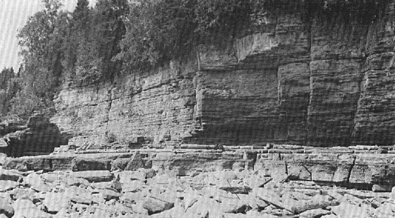
The Sainte-Anne Formation consists of dark limestone, varying from finely crystalline to dense and arranged in thin strips (Clark and Globensky, 1969; Clark and Globensky, 1973; Globensky, 1993; MNRF, 2009; Thériault, 2014). Upper beds are interstratified with soft shale. In the Sainte-Anne River gorge, 150 to 360 m downstream of the Saint-Alban bridge, Clark and Globensky (1975) described a 1.5 m horizontal limestone sequence between the underlying Leray Formation (Black River Group) and the overlying Deschambault Formation:
| Deschambault Formation | Coarse-grained crystalline limestone | … |
| Sainte-Anne Formation | Limestone in beds 50-76 cm thick separated by soft schistose partings | 0.30 m |
| Bed of limestone conglomerate in which pebbles do not exceed 8 cm diameter | ||
| Limestone in beds 50-76 cm thick separated by soft schistose partings | 0.46 m | |
| Well welded limestone | 0.76 m | |
| Leray Formation (Black River Group) | Grey-brown limestone, filled in places with very fine sand | … |
Thickness and distribution
The Sainte-Anne Formation is only 1.5 m at the type locality (Globensky, 1987; Globensky, 1993) and only outcrops along the Sainte-Anne River, north of Saint-Alban (NE corner of sheet 31I09). There, it forms a thin (<350 m wide) curved strip that extends for about 15 km.
Dating
None.
Stratigraphic Relationship(s)
The Sainte-Anne Formation overlies the Leray Formation (Black River Group), without apparent unconformity (Clark and Globensky, 1975; Globensky, 1987; Globensky, 1993). However, Okulitch (1939) mentions the presence of truncated fossils, as well as the wind origin of the formation’s sand grains. The Sainte-Anne Formation is correlated with the Pont-Rouge, Fontaine and Ouareau formations, as all units represent basal units of the Trenton Group and are in contact with the overlying Deschambault Formation (Clark, 1959; Clark and Globensky, 1973, 1975; Globensky, 1987, 1993).
Paleontology
Fossils are rare and fragmented. Clark and Globensky (1975) noted the presence of Conularia, Rafinesquina, Dalmenella, Bumastus and ostracods. The presence of Conularia sp., Paucicrura sp. and many Dalmenella justify to include this formation into the Trenton Group (Clark and Globensky, 1975; Globensky, 1993).
References
Publications Available Through SIGÉOM Examine
CLARK, T H., GLOBENSKY, Y. 1969. PORTNEUF AND PARTS OF ST-RAYMOND AND LYSTER MAP-AREAS, PORTNEUF AND LOTBINIERE COUNTIES – GEOLOGICAL REPORT. MRN. DP 051, 284 pages and 3 plans.
CLARK, T H., GLOBENSKY, Y. 1973. PORTNEUF AND PARTS OF SAINT-RAYMOND AND LYSTER MAPS ARES, PORTNEUF AND LOTBINIERE COUNTIES. MRN. RG 148(A), 112 pages and 1 plan.
CLARK, T H., GLOBENSKY, Y. 1973. REGION DE PORTNEUF ET PARTIES DE ST-RAYMOND ET DE LYSTER, COMTES DE PORTNEUF ET DE LOTBINIERE. MRN. RG 148, 117 pages and 1 plan.
CLARK, T H., GLOBENSKY, Y. 1975. REGION DE GRONDINES. MRN. RG 154, 171 pages and 1 plan.
GLOBENSKY, Y. 1987. GEOLOGIE DES BASSES-TERRES DU SAINT-LAURENT. MRN. MM 85-02, 71 pages and 1 plan.
GLOBENSKY, Y. 1993. LEXIQUE STRATIGRAPHIQUE CANADIEN – VOLUME V-B – REGION DES APPALACHES, DES BASSES-TERRES DU SAINT-LAURENT ET DES ILES DE LA MADELEINE. MRN. DV 91-23, 336 pages.
MRNF 2009. COMPILATION GÉOLOGIQUE, 31I09 – GRONDINES. In : MRNF. 2010. CARTE(S) GÉOLOGIQUE(S) DU SIGEOM – feuillet 31m. CG SIGEOM31M, 36 plans.
THERIAULT, R. 2014. GEOLOGIE DES BASSES-TERRES DU SAINT-LAURENT. MERN. DV 2014-05, 1 plan.
Other Publications
CLARK, T.H. 1959. Stratigraphy of the Trenton Group, St. Lawrence Lowlands, Quebec. Geological Association of Canada; proceedings 1959, pages 13-21.
OKULITCH, V.J. 1939. The Black River Group in the region between Montreal and Quebec. American Journal of Sciences; volume 237, pages 81-93.