


First published: 20 January 2020
Last modified:
DISCLAIMER: This English version is translated from the original French. In case of any discrepancy, the French version shall prevail.
| Author(s): | Dimroth, 1978 |
| Age: | Paleoproterozoic |
| Stratotype: | The type locality is to the west of Le Fer Lake (NTS sheet 23O06) where the formation outcrops well. |
| Type area: | Le Fer Lake area (NTS sheet 23O06) |
| Geological province: | Churchill Province |
| Geological subdivision: | New Quebec Orogen (Labrador Trough) |
| Lithology: | Shale, siltstone, sandstone, dolomite |
| Category: | Lithostratigraphic |
| Rank: | Formation |
| Status: | Formal |
| Use: | Active |
Background
Red, green, grey and black shales locally containing interbedded sandstone and dolomite were described by Harrison (1952), Frarey (1961), Frarey and Duffell (1964), Baragar (1967), Dimroth (1970a, 1971), Dimroth et al. (1970) and Harrison et al. (1972) in the southern part of the Labrador Trough, NW of Schefferville. These authors then incorporated these lithologies into the « Attikamagen Formation », which was later elevated to the rank of « subgroup » by Dimroth (1970b, 1972, 1978). Dimroth (1978) introduced the name Le Fer Formation to refer to a poorly stratified, red, green or grey, silty shale unit located west of Le Fer Lake (NTS sheet 23O06), from which it takes its name, and included it in the « Attikamagen Subgroup ». Following the change in status of the Attikamagen unit, Wardle (1982) replaced the term « Attikamagen Formation », then in use in the southern Labrador Trough, with the Le Fer Formation. Clark and Wares (2004) later redefined Dimroth’s « Attikamagen Subgroup » as the Attikamagen Group. According to Dimroth (1978), the Le Fer and Bacchus formations, which consist largely of flyschoid sedimentary rocks, form the lower part of the Attikamagen Group. Dimroth (1978) also pointed out that the Le Fer is transitional and interdigitated with adjacent formations including the Savigny and Bacchus formations. Because of the similarities between these formations, Clark and Wares (2004) proposed that the Le Fer and Bacchus formations be included in the Swampy Bay Group. In compiling sheet 24F11 (Lafrance et al., 2012), other mudrock, siltstone and sandstone sequences described by Clark (1978) south of the Koksoak River were assigned to the Le Fer Formation by virtue of their similar stratigraphic position to the sequence further south.
Description
Le Fer Formation, Undivided (pPlf): Silty Shale; Interbedded Siltstone, Sandstone and Dolomite
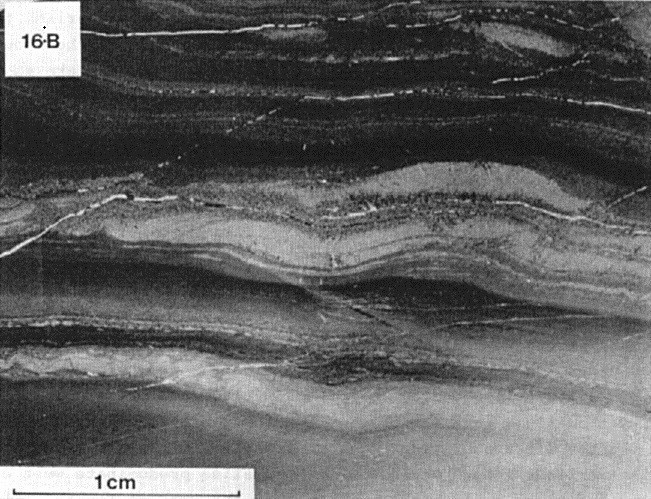
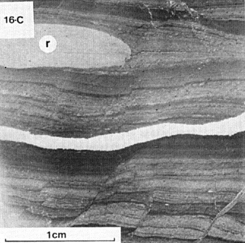
This undivided unit corresponds to the Le Fer Formation as mapped NW of Schefferville by Dimroth (1978). In this area, the Le Fer Formation is a sedimentary unit typically consisting of red, green or grey, poorly laminated silty shale (Dimroth, 1978). The transition from one colour to another is irregular and occurs over short distances. Red and/or green silty shale generally predominates in the western part of the Labrador Trough and changes towards the east to a grey, finely laminated silty shale. According to Dimroth (1978), the Le Fer shale is characterized by a relatively coarse-grained silty component, which is invariably present. Laminations are therefore poor and result from small variations in composition. However, laminations are more prominent in mottled shales where red and green borders alternate. Millimetre to centimetre-thick tabular laminations are characteristic. Dimroth (1978) also observed rare clay pebbles. On outcrops, the detailed layering is hardly visible due to minute variations in the composition of laminations. A lesser amount of carbonate is invariably present in shale (Dimroth, 1978).
Interbedded red, green, yellow or grey fine-grained sandstone and siltstone, 5 to 20 cm thick, are commonly observed in silty shale. Some interbedded medium-grained sandstone is also observed. Beds or lenses of dolomitic mudrock, schistose dolomite or dolomite, up to 30 cm thick, are also found interbedded with silty shale. These dolomite beds or lenses are generally found in the upper part of the formation (Dimroth, 1978). Dolomitic mudrock and schistose dolomite are light grey, green or red. They display millimetric to centimetric tabular laminations. Dolomitic laminae are grey and altered to brown. Crossbedding is rarely observed. Dolomite is well stratified or massive and recrystallized with chert concretions and quartz veinlets (Dimroth, 1978).
Red and green shale is interpreted as a pro-deltaic, still-water deposit of sediments from a spring to the west, while grey shale is thought to have been deposited in a deeper basin to the east (Dimroth, 1971, 1978; Clark and Wares, 2004).
Le Fer Formation 1 (pPfl1): Grey, Dark Grey, Black and Green Shale, Siltstone and Sandstone; Interbedded Quartzitic Sandstone Locally
The rocks belonging to unit pPlf1 outcrop south of the Koksoak River (Clark, 1978) and were assigned to the Le Fer Formation during compilation of sheet 24F11 (Lafrance et al., 2012). The unit consists of grey, dark grey, black or green shale, siltstone and sandstone. Sandstone and siltstone are fissile, very fine-grained, and contain local beds of coarser-grained quartzitic sandstone up to 2 m thick. Shale contains some disseminated pyrite cubes near the contact with overlying grey dolomite of the Denault Formation (pPde2) (Clark, 1978).
Thickness and Distribution
The Le Fer Formation belongs to the Howse, Mélèzes and Schefferville lithotectonic zones, as defined by Clark and Wares (2004). South of latitude 55°30’N, it forms a strip oriented NW-SE, 105 km long and up to 19 km wide. A small occurrence also occurs northwest of Cramolet Lake (sheet 23O13). According to Wardle and Bailey (1981), the thickness of the formation is estimated to be between 500 and 1000 m. The Le Fer Formation also occurs south of the Koksoak River and 1 to 2 km east of the Caniapiscau River (sheet 24F11) where it forms a strip ~14 km long parallel to the Caniapiscau River. In this area, the exposed thickness of the formation varies from ~90 to 145 m (Clark, 1978).
Dating
None.
Stratigraphic Relationship(s)
The rocks of the Le Fer Formation were deposited during the first volcano-sedimentary cycle of the Labrador Trough, between 2169 ±4 and 2142 +4/-2 Ma (T. Krogh and B. Dressler, unpublished data cited in Clark, 1984, page 4; Rohon et al., 1993; Clark and Wares, 2004). In the area between Wakuach Lake and Schefferville, the Le Fer Formation is overlying the rocks that are equivalent to the Swampy Bay Group (unit pPsw1) and underlies the Wishart and Denault formations (Dimroth et al., 1970; Dimroth, 1978). The transition from the Le Fer Formation to Swampy Bay Group equivalents was not observed by Dimroth (1978). According to him, folds generally dip towards the SSE between Wakuach and Le Fer lakes, suggesting that Swampy Bay Group equivalents underlie the Le Fer Formation. The contact between dolomite of the Denault Formation and the Le Fer Formation is generally sharp and appears to be widely interdigitated (Dimroth, 1978). South of Wakuach Lake, the Le Fer Formation gradually changes eastward to the Denault Formation (Dimroth, 1978). East of Le Fer Lake, near the Ferrum River, the Le Fer Formation is interdigitated with the adjacent Savigny and Bacchus formations (Dimroth, 1978). Dimroth (1978) also demonstrated that the Le Fer and Bacchus formations are separated by a thrust fault (Ferrum River Fault) (sheet 23O02). According to Dimroth et al. (1970), the contact between the Wishart Formation and the Le Fer Formation is an erosional unconformity. East of the Caniapiscau River (sheet 24F11), the Le Fer Formation is in sharp contact with the overlying Denault Formation. The contact between the two formations is well exposed and not interstratified (Clark, 1978).
Paleontology
Does not apply.
References
Publications Available Through SIGÉOM Examine
CLARK, T. 1978. REGION DU LAC HERODIER (NOUVEAU-QUEBEC) – RAPPORT PRELIMINAIRE. MRN. DPV 568, 48 pages and 2 plans.
CLARK, T. 1984. GEOLOGIE DE LA REGION DU LAC CAMBRIEN – TERRITOIRE DU NOUVEAU-QUEBEC. MRN. ET 83-02, 77 pages and 1 plan.
CLARK, T., WARES, R. 2004. SYNTHESE LITHOTECTONIQUE ET METALLOGENIQUE DE L’OROGENE DU NOUVEAU-QUEBEC (FOSSE DU LABRADOR). MRNFP. MM 2004-01, 182 pages and 1 plan.
DIMROTH, E. 1970. CARTES GEOLOGIQUES DU LAC ROMANET ET DU LAC CRAMOLET (FOSSE DU LABRADOR). MRN. DP 068, 3 plans.
DIMROTH, E. 1972. STRATIGRAPHY OF PART OF THE CENTRAL LABRADOR TROUGH. MRN. DP 154, 304 pages and 6 plans.
DIMROTH, E. 1978. REGION DE LA FOSSE DU LABRADOR ENTRE LES LATITUDES 54° 30′ ET 56° 30′. MRN. RG 193, 417 pages and 16 plans.
LAFRANCE, I., BANDYAYERA, D., SIMARD, M. 2012. GEOLOGIE – GORGE DU MANITOU. MRN. CG-24F11-2012-01, 1 plan.
Other Publications
BARAGAR, W R A., 1967. Wakuach Lake map-area, Quebec-Labrador (23O). Geological Survey of Canada; Memoir 344, 174 pages. http://doi.org/10.4095/123960
DIMROTH, E., 1970. Evolution of the Labrador Geosyncline. Geological Society of America Bulletin; volume 81, pages 2717-2742. http://doi.org/10.1130/0016-7606(1970)81[2717:EOTLG]2.0.CO;2
DIMROTH, E., 1971. The Attikamagen-Ferriman transition in part of the central Labrador Trough. Canadian Journal of Earth Sciences; volume 8, pages 1432-1454. http://doi.org/10.1139/e71-132
DIMROTH, E., BARAGAR, W R A, BERGERON, R, JACKSON, G D., 1970. The filling of the Circum-Ungava geosyncline. In: Symposium on Basins and Geosynclines of the Canadian Shield (A.J. Baer, editor). Geological Survey of Canada; Paper 70-40, pages 45-142. http://doi.org/10.4095/124922
FRAREY, M J., 1961. Geology, Menihek Lakes, Newfoundland and Quebec; Geological Survey of Canada; Map 1087A. http://doi.org/10.4095/124105
FRAREY, M. J., DUFFELL, S., 1964. Revised stratigraphic nomenclature for the central part of the Labrador Trough. Geological Survey of Canada; Paper 64-25, 13 pages. http://doi.org/10.4095/123909
HARRISON, J M., 1952. The Quebec-Labrador iron belt, Quebec and Newfoundland. Geological Survey of Canada; Paper 5220, 21 pages. http://doi.org/10.4095/123923
FAHRIG, W F, HARRISON, J M, HOWELL, J E., 1978. A geological cross-section of the Labrador miogeosyncline near Schefferville, Quebec. Geological Survey of Canada; paper 70-37, 40 pages. http://doi.org/10.4095/102389
ROHON, M.-L., VIALETTE, Y., CLARK, T., ROGER, G., OHNENSTETTER, D., VIDAL, PH., 1993. Aphebian mafic-ultramafic magmatism in the Labrador Trough (New Quebec): its age and the nature of its mantle source. Canadian Journal of Earth Sciences; volume 30, pages 1582-1593. http://doi.org/10.1139/e93-136
WARDLE, R.J., 1982. Geology of the south-central Labrador Trough. Government of Newfoundland and Labrador, Department of Mines and Energy, Mineral Development Division, Map 82-005. http://gis.geosurv.gov.nl.ca/geofilePDFS/ReceivedBatch58/LAB_0603.pdf
WARDLE, R J, BAILEY, D G., 1981. Early Proterozoic sequences in Labrador. In: Proterozoic Basins in Canada (F.H.A. Campbell, editor). Geological Survey of Canada; Study 81-10, pages 331-358. http://doi.org/10.4095/124192
Suggested Citation
Ministère de l’Énergie et des Ressources naturelles (MERN). Le Fer Formation. Quebec Stratigraphic Lexicon. https://gq.mines.gouv.qc.ca/lexique-stratigraphique/province-de-churchill/formation-de-le-fer_en [accessed on Day Month Year].
Contributors
|
First publication |
Charles St-Hilaire, GIT, M.Sc. charles.st-hilaire@mern.gouv.qc.ca (redaction) Mehdi A. Guemache, P. Geo., Ph.D. (redaction and coordination); Thomas Clark, P. Geo., Ph.D. (critical review); Simon Auclair, P. Geo., M.Sc. (editing); Céline Dupuis, P. Geo., Ph.D. (English version); Ricardo Escobar Moran and Nathalie Bouchard (HTML editing). |