


First published: 21 January 2020
Last modified:
DISCLAIMER: This English version is translated from the original French. In case of any discrepancy, the French version shall prevail.
| Author(s): | Dimroth, 1968 |
| Age: | Paleoproterozoic |
| Stratotype: | The type locality is to the north and east of Savigny Lake (NTS sheet 24C07) |
| Type area: | Savigny Lake area (NTS sheet 24C07) |
| Geological province: | Churchill Province |
| Geological subdivision: | New Quebec Orogen (Labrador Trough) |
| Lithology: | Mudstone, slate, siltstone, greywacke, dolomite |
| Category: | Lithostratigraphic |
| Rank: | Formation |
| Status: | Formal |
| Use: | Active |
Background
The first descriptions of these lithologies come from the work of Roscoe (1957). The name Savigny Formation was introduced by Dimroth (1968) in the Savigny Lake area to designate a sequence of finely bedded grey silty slate. Rocks of the Savigny Formation were mapped by Fahrig (1969), Dimroth (1969, 1970a, 1972, 1978), Dressler (1973, 1974, 1975, 1979) and Clark (1984).
Description
The Savigny Formation is a sedimentary unit consisting mainly of finely bedded and laminated grey to dark grey mudstone, slate and siltstone having a light grey to rusty-brown alteration patina, and graphitic black quartzitic wacke. Mudstone, slate and siltstone include rare centimetre scale interbedded wacke and grey dolomite having a light brown patina (Dimroth, 1978; Dressler, 1979). In the Savigny Lake area, black graphitic quartzitic wacke is an important unit of the formation. It is interbedded with black graphitic slate (Dimroth, 1978). Clark (1984) mentions the presence of centimetric beds of black sandstone and, at one locality, of a 15 m thick layer of medium to coarse-grained quartz sandstone. Sedimentary structures typically include lamination, crossbedding and sorting (Dimroth, 1978; Clark, 1984). Clark (1984) mentions the presence of sequences in which the grain size increases upwards. A few carbonate concretions are commonly observed in rocks of the formation (Dimroth, 1978, Chevé, 1993). Rocks of the Savigny Formation were formed in relatively calm and deep water. They are interpreted as turbidites by Dimroth (1978) and Clark (1984). In addition, Clark (1984) interpreted the sequences that increase in grain size upwards as part of seaward-progressing alluvial fans. He also mentions that these turbidites were deposited in an intermediate and distal environment. According to Clark (1984), sandstone units were deposited in channels cut into turbidite fans.
Savigny Formation 1 (pPsv1): Grey or Black sSate, Grey Siltstone and Mudstone; Rare Interbedded Wacke and Graphitic Dolomite
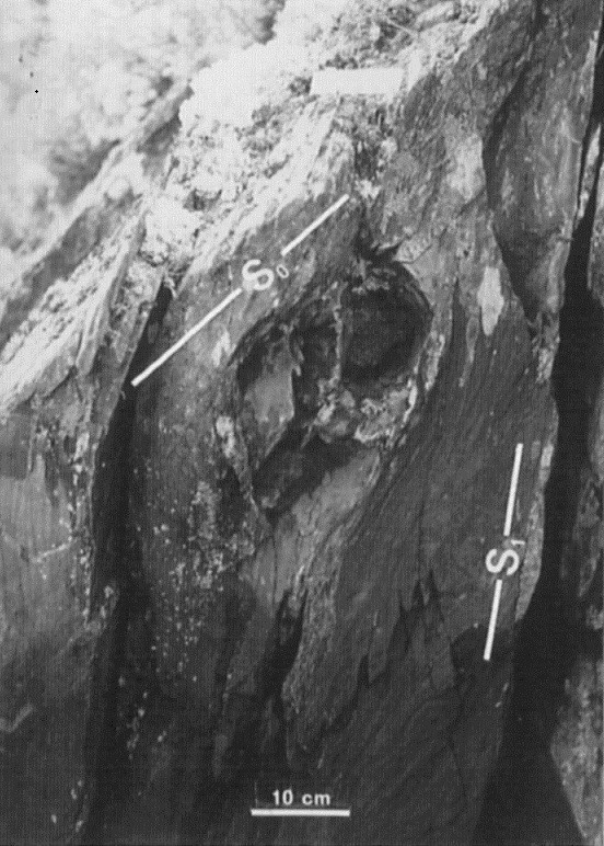
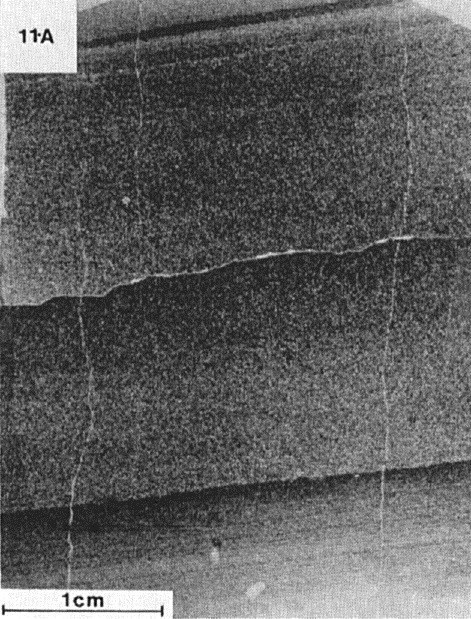
Unit pPsv1 consists of mudstone, slate and siltstone typically dark grey in fresh surface, light grey or rusty-brown in altered surface, finely bedded and laminated (Dimroth, 1969, 1978; Dressler, 1979). These rocks form centimetric to metric layers, locally interbedded with centimetric beds of wacke and grey dolomite having a light brown patina (Dimroth, 1978; Dressler, 1979). In the Doutreleau Lake area (sheet 24C10), Dressler (1979) mentions, among other things, the presence of about twenty mudstone beds (2 cm to 6 m thick, averaging 5-20 cm) interbedded with dark grey dolomite beds 2 cm to 1.2 m thick. Black graphitic dolomite beds ~2 cm thick are interbedded in mudstone and slate at the base of the Savigny Formation in the High Falls area (sheet 24C01) (Dimroth, 1978). Ankerite porphyroblasts are commonly observed (Dimroth, 1978; Chevé, 1993). Mudstone and slate generally display very regular stratification with thin, millimetre-thick parallel laminae (1-10 mm) and fine crossbedding (Dimroth, 1969, 1978; Dressler, 1979). Sorting is observed locally, while flaser-like lamination is rare (Dimroth, 1969). Siltstone occurs in thin,1 to 10 mm-thick laminae and has one cleavage, locally two (Dressler, 1979). Dolomite is usually finely bedded and recrystallized. It is arenaceous or argillaceous in places. Very thin veinlets of chalcedonic chert, a few millimetres apart, are commonly observed in dolomite. They are perpendicular to the dolomite’s stratification (Dressler, 1979).
In the Mort Lake area, west of Cambrien Lake (sheets 24C03 and 24C06), the unit consists of dark grey, fissile and laminated mudstone and siltstone, locally interbedded with thin (1 cm) black sandstone. In addition to lamination, sedimentary structures are sparse and include ripples, sorting, siltstone-mudstone clasts in sandstone beds and load prints. Disseminated pyrite is observed locally. The base of the unit is clearly visible on the shore of Cambrien Lake, overlying grey dolomite of the Pistolet Group. There, it is represented by a 1 m-thick layer of folded and crenulated, black pyritic, highly graphitic slate. Slate is overlain by very slightly deformed, locally graphitic mudstones (Clark, 1984). Clark (1984) speculated that these black slates may correlate with black slates of the Hautes-Chutes Formation.
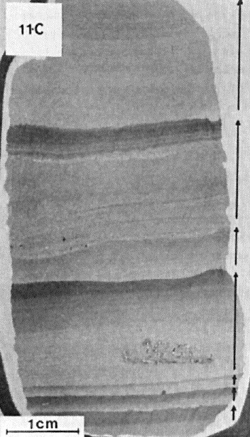
In thin sections, mudstone and slate are composed of 30 to 40% quartz fragments (silt grain size) in an argillaceous chlorite-sericite matrix (Dressler, 1979). Minor amounts of graphite are noted in places (Dressler, 1979). Siltstone is formed by angular fragments of quartz and feldspar (silt grain size) in a matrix of chlorite, sericite and some carbonate. Bedding is marked by alternating laminae enriched (50-80%) and depleted (30% or less) in silty particles (Dressler, 1979).
Savigny Formation 2 (pPsv2): Black Graphitic Slate, Locally Pyritic; Interbedded Black Graphitic Wacke
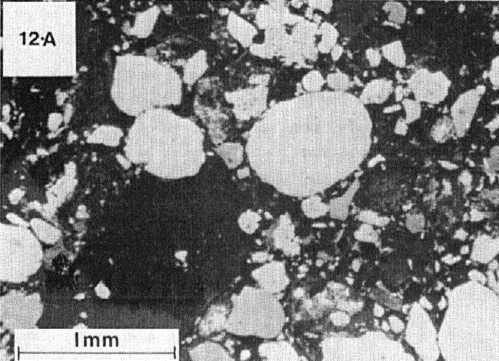
Unit pPsv2 occupies an area several hundred metres thick in the upper part of the formation to the NW and SE of Savigny Lake (Dimroth, 1978). Rocks consist of graphitic black slate and interbedded graphitic black quartzitic wacke 2 to 20 cm thick. Graphitic black slate is locally pyritic (Clark, 1984). Black quartzitic wacke is composed of rounded quartz grains and rare feldspar grains (<2 mm diameter), chert fragments, calcareous siltstone and fine-grained dolomitic sandstone, and grey slate in a matrix of graphitic black slate. Sorting is commonly observed. Cleavage planes in slates are parallel to stratification planes (Dimroth, 1969, 1978). According to (Dimroth, 1978), it is not possible to say whether the beds contain structures that could indicate flow directions.
Thickness and distribution
The Savigny Formation belongs to the Cambrien and Schefferville lithotectonic zones, as defined by Clark and Wares (2004). It outcrops well in the Savigny Lake basin (sheet 24C07) and at the High Falls of the Swampy Bay River (sheet 24C01), as well as along the Swampy Bay River (Dimroth, 1969). It is >600 m thick in the Savigny Lake area and <300 m west of Otelnuk Lake (sheet 24C01) (Dimroth, 1969, 1978). The formation gradually thins from Savigny Lake to Otelnuk Lake (Dimroth, 1978). It is also found west of Cambrien Lake in the axial part of the Rivière de la Mort Syncline (sheet 24C03), where it is estimated to be 35 m thick (Clark, 1984). East of Cambrien Lake (sheet 24C06), the formation is >45 m thick, but its total thickness may be greater than reported (Clark, 1984). The Savigny Formation was mapped by Dressler (1979) SW of Canichico Lake (sheets 24C10 and 24C15) and in the Edgar Lake area (sheet 24C10). Dressler (1979) also mapped it west of Doutreleau Lake (sheets 24C07 and 24C10), where it represents the extension of the terrain mapped by Dimroth (1978).
Dating
None.
Stratigraphic Relationship(s)
Deposition of the Savigny Formation took place between 2169 ±4 and 2142 +4/-2 Ma, i.e., during the period of deposition of first-cycle sedimentary rocks (T. Krogh and B. Dressler, unpublished data cited by Clark, 1984, page 4; Rohon et al., 1993; Clark and Wares, 2004). The Savigny Formation is older than carbonatite dykes that cut it and that belong to the Castignon Volcanic Complex, which has been dated 1880 ±2 Ma (Chevé and Machado, 1988).
In the Otelnuk Lake area, the Savigny Formation is overlying the Hautes-Chutes Formation and underlying the Otelnuc Formation (Dimroth, 1978). The lower contact of the Savigny Formation with the Hautes Chutes Formation is not visible, but the relationship between the two formations at the Swampy Bay River High Falls suggests a gradual contact (Dimroth, 1969, 1978). Dimroth (1978) suggests that the Savigny Formation can be partly correlated with the Otelnuc Formation.
In the Goethite Lake area (sheet 24C07), the Savigny Formation is unconformably overlain by the Wishart Formation (Ferriman Group) (Dimroth, 1978). At the Mort River, on the west shore of Cambrien Lake, it is overlying a dolomite unit of the Pistolet Group (Clark, 1984). South of Edgar Lake (sheet 24C10), it overlies rocks of the Uvé Formation and is overlain by rocks of the Ferriman Group (Dressler, 1979). According to Dimroth (1978), the Savigny Formation is transitional and interdigitated with the adjacent Le Fer Formation. Fragments of Savigny Formation slate are observed in breccias of the Castignon Volcanic Complex (Dimroth, 1969, 1970b, 1970c, 1978; Chevé, 1993).
Paleontology
Does not apply.
References
Publications Available Through SIGÉOM Examine
CHEVÉ, S. 1993. CADRE GÉOLOGIQUE DU COMPLEXE CARBONATITIQUE DU LAC CASTIGNON – FOSSE DU LABRADOR. MINISTÈRE DE L’ÉNERGIE ET DES RESSOURCES, QUÉBEC; MB 93-64, 100 pages and 1 plan.
CLARK, T. 1984. GÉOLOGIE DE LA RÉGION DU LAC CAMBRIEN – TERRITOIRE DU NOUVEAU-QUÉBEC; MINISTÈRE DE L’ÉNERGIE ET DES RESSOURCES; QUÉBEC; ET 83-02, 77 pages and 1 plan.
CLARK, T., WARES, R. 2004. SYNTHÈSE LITHOTECTONIQUE ET MÉTALLOGÉNIQUE DE L’OROGÈNE DU NOUVEAU-QUÉBEC (FOSSE DU LABRADOR); MINISTÈRE DE L’ÉNERGIE ET DES RESSOURCES; QUÉBEC; MM 2004-01, 182 pages and 1 plan.
DIMROTH, E. 1969. GÉOLOGIE DE LA RÉGION DU LAC CASTIGNON, TERRITOIRE DU NOUVEAU-QUÉBEC. MINISTÈRE DES RICHESSES NATURELLES, QUÉBEC; RP 571, 62 pages, 7 plans.
DIMROTH, E. 1984. CARTES GÉOLOGIQUES DU LAC ROMANET ET DU LAC CRAMOLET (FOSSE DU LABRADOR). MINISTÈRE DES RICHESSES NATURELLES, QUÉBEC; DP 068, 3 plans.
DIMROTH, E. 1972. STRATIGRAPHY OF PART OF THE CENTRAL LABRADOR TROUGH. MINISTÈRE DE L’ÉNERGIE ET DES RESSOURCES, QUÉBEC; DP 154, 304 pages and 6 plans.
DIMROTH, E. 1978. RÉGION DE LA FOSSE DU LABRADOR ENTRE LES LATITUDES 54°30′ ET 56°30′. MINISTÈRE DE RICHESSES NATURELLES, QUÉBEC; RG 193, 417 pages and 16 plans.
DRESSLER, B. 1973. GÉOLOGIE DE LA RÉGION DU LAC PATU, TERRITOIRE DU NOUVEAU-QUÉBEC. MINISTÈRE DES RICHESSES NATURELLES, QUÉBEC, RP-603, 26 pages, 1 plan.
DRESSLER, B. 1974. GEOLOGY OF THE FORT MCKENZIE, SHALE FALLS (EAST HALF), MORAINE LAKE (EAST HALF) AND LA LANDE LAKE AREAS, NEW QUEBEC TERRITORY, INTERIM REPORT. MINISTÈRE DES RICHESSES NATURELLES, QUÉBEC, DP 247, 60 pages.
DRESSLER, B. 1975. GEOLOGY OF THE FORT MCKENZIE, SHALE FALLS (EAST HALF), MORAINE LAKE (EAST HALF) AND LA LANDE LAKE AREAS, NEW QUEBEC TERRITORY, INTERIM REPORT. MINISTÈRE DES RICHESSES NATURELLES, QUÉBEC, RP 608, 32 pages, 1 plan.
DRESSLER, B. 1979. RÉGION DE LA FOSSE DU LABRADOR (56°30′ – 57°15′). MINISTÈRE DES RICHESSES NATURELLES, QUÉBEC; RG 195, 136 pages, 14 plan.
Other Publications
CHEVÉ, S.R., MACHADO, N. 1988. Reinvestigation of the Castignon Lake carbonatite complex, Labrador Trough, New Québec. Joint Annual Meeting of the Geological Association of Canada and the Mineralogical Association of Canada, St. John’s, Newfoundland; Program with Abstracts, volume 13, pages 20.
DIMROTH, E. 1968. The evolution of the central segment of the Labrador geosyncline; part I: stratigraphy, facies and paleogeography; Neues Jahrbuch fuer Geologie und Paläontologie, Abhandlungen, Stuttgart; volume 132, pages 22-54.
DIMROTH, E. 1970b. Meimechites and carbonatites of the Castignon Lake Complex, New Quebec. Neues Jahrbuch für Mineralogie, Abhandlungen; volume 112, pages 239-278.
DIMROTH, E. 1970c. Evolution of the Labrador Geosyncline. Geological Society of America Bulletin; volume 81, pages 2717-2742. http://doi.org/10.1130/0016-7606(1970)81[2717:EOTLG]2.0.CO;2
FAHRIG, W.F. 1969. Géologie Lac Cambrien, moitié ouest, Québec. Commission géologique du Canada; Carte 1223A (1:250 000). http://doi.org/10.4095/108893
ROHON, M.-L., VIALETTE, Y., CLARK, T., ROGER, G., OHNENSTETTER, D., VIDAL, P. 1993. Aphebian mafic-ultramafic magmatism in the Labrador Trough (New Quebec): its age and the nature of its mantle source. Canadian Journal of Earth Sciences; volume 30, pages 1582-1593. http://doi.org/10.1139/e93-136
ROSCOE, S.M. 1957. Cambrian Lake (east half), Quebec. Geological Survey of Canada; Paper 57–6, 16 pages. http://doi.org/10.4095/101318
Suggested Citation
Ministère de l’Énergie et des Ressources naturelles (MERN). Savigny Formation. Quebec Stratigraphic Lexicon. https://gq.mines.gouv.qc.ca/lexique-stratigraphique/province-de-churchill/formation-de-savigny_en [accessed on Day Month Year].
Contributors
First publication | Charles St-Hilaire, GIT, M.Sc. charles.st-hilaire@mern.gouv.qc.ca (redaction) Mehdi A. Guemache, P. Geo., Ph.D. (redaction and coordination); Thomas Clark, P. Geo., Ph.D. (critical review); Simon Auclair, P. Geo., M.Sc. (editing); Céline Dupuis, P. Geo., Ph.D. (English version); Ricardo Escobar Moran (HTML editing). |