


Last modified: 9 December 2022
DISCLAIMER: This English version is translated from the original French. In case of any discrepancy, the French version shall prevail.
None
| Author(s): | Buchan et al., 1993 |
| Age: | Paleoproterozoic |
| Stratotype: | B2 dyke of Buchan et al. (1993), which cuts Archean rocks in the Biscotasing village region, Ontario, located at 145 km WSW of Timmins. In the Munro Township, Ontario (NTS sheet 42E09), this dyke outcrops at the following coordinates: UTM, NAD 83, Zone 17 : 573272 m E, 5322331 m N. |
| Type area: | NE Ontario and Abitibi, Quebec. |
| Geological province: | Superior Province |
| Geological subdivision: | Abitibi, Wawa (Ontario) and Opatica subprovinces |
| Lithology: | Quartz gabbronorite |
| Category: | Lithodemic |
| Rank: | Suite |
| Status: | Formal |
| Use: | Active |
None
Background
From the beginning of geological mapping in Quebec and Ontario, geologists have identified dykes and late diabase sills (e.g., Murray et al., 1897). L’Espérance (1948) and Gill and L'Espérance (1952) noted that these intrusions, present throughout the Canadian Shield, were most likely of Keweenawian (Mesoproterozoic) age and could be classified into three categories: 1) undifferentiated or ordinary diabase; 2) quartz diabase; and 3) olivine diabase. Moore (1929) concluded that olivine diabases were consistently younger than quartz diabases. The Fahrig and West (1986) map, based on compilations and interpretation of aeromagnetic surveys, presents the distribution of diabase dyke swarms in the Canadian Shield and their chronology based on isotopic ages. On this map, NE orientated dykes of western Quebec were associated with the Preissac Swarm. Later, the paleomagnetism and geochronology work of Buchan et al. (1993) divided these dykes into two groups: the Senneterre Dykes and the Biscotasing Dykes.
Description
The Biscotasing diabase Dykes were traced from outcrop distribution and the magnetic field vertical gradient map. These mafic intrusions, oriented NNE to NE extend in a straight line over kilometers.
The thickness of the dykes varies from a few meters to 133 m. Diabase has a brown patina and a green fresh exposure. The contact with host rocks is sharp and generally corresponds to an aphanitic chill margin one to a few centimeters thick. The center of the dykes is medium-grained. The rock is massive, homogeneous and slightly deformed. Fracture networks perpendicular to the dyke orientation are recognized.
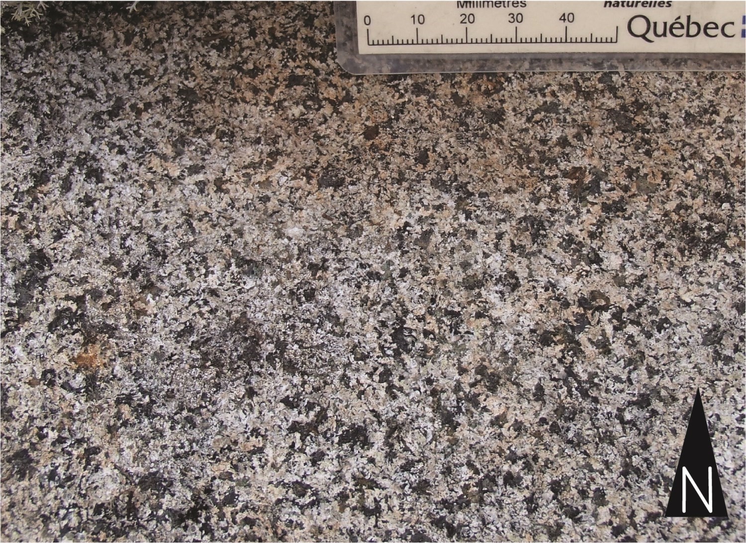 The Biscotasing Dykes consist of medium-grained gabbronorite composed of augite, plagioclase and orthopyroxene showing an intergranular to ophitic microstructure. Accessory minerals include magnetite-ilmenite (1 to 3%), quartz (1 to 4%), apatite and traces of biotite. The level of uralization and sericitization varies from low to high. Orthopyroxene is more altered (to chlorite, serpentine, amphibole) and is therefore more difficult to recognize in thin sections. In Ontario, Halls et al. (2005) report that the Hillport Dyke, one of the thickest dykes in this unit, contains plagioclase crystals up to one centimeter in length.
Thickness and distribution
The Biscotasing Dykes were recognized in an area extending from Kistingan Lake, Manitoba to Senneterre, Quebec, covering an area of 450,000 km2 (calculated from Figure 17.1 of Hamilton and Stott, 2008, excluding the Otish Mountains area). They cut Archean rocks of the Superior Province, as well as clastic rocks of the Cobalt Group of Fallon Township, Ontario (Pyke, 1972) and those north of Elliot Lake (Halls and Davis, 2004).
Dating
The age of the Biscotasing Dykes ranges from 2174.6 Ma to 2166.7 Ma. Their emplacement is contemporaneous with that of the Otish gabbroic sills (2172.2 ±1.7 Ma to 2162.5 ±6.2 Ma; Hamilton and Buchan, 2016; Milidragovic et al., 2016), the Rivière Payne Dykes (2170-2160 Ma, cited in Hamilton and Buchan, 2016) and the Montagnais Supersuite sills in the Cramolet Lake area in the Labrador Trough (pPmon; 2169 ±2 Ma; Rohon et al. 1993).
| Isotopic System | Mineral | Cristallization Age (Ma) | (+) | (-) | Reference(s) |
| U-Pb | Baddeleyite | 2170,7 | 1,1 | 1,1 | Davis et Stott, 2003; Halls et al., 2005 |
| 2167,8 | 2,2 | 2,2 | Halls et Davis, 2004 | ||
| 2171,6 | 1,2 | 1,2 | Halls et Davis, 2004 | ||
| 2174,6 | 3,2 | 3,2 | Hamilton et Stott, 2008 | ||
| 2166,7 | 1,4 | 1,4 | Buchan et al., 1993 |
Stratigraphic Relationship(s)
The Biscotasing Dykes cut Archean rocks of the Superior Province. They are locally intrusive in shear zones or major regional faults.
Paleontology
Does not apply.
References
Publications available through SIGÉOM Examine
L'ESPERANCE, R L., 1948. A STUDY OF THE DIABASE DYKES OF THE CANADIAN SHIELD. TH 0306
Other publications
BUCHAN, K.L., MORTENSEN, J.K., CARD, K.D., 1993. Northeast-trending Early Proterozoic dykes of the southern Superior Province: multiple episodes of emplacement recognized from integrated paleomagnetism and U-Pb geochronology. Canadian Journal of Earth Sciences; volume 30, pages 1286-1296. https://doi.org/10.1139/e93-110
DAVIS, D.W., STOTT, G.M., 2003. Geochronology of two Proterozoic mafic dike swarms in northwestern Ontario. In: Summary of Field Work and Other Activities 2003. Ontario Geological Survey; Open File Report 6120, pages 12-1 - 12-7. http://www.geologyontario.mndmf.gov.on.ca/mndmfiles/pub/data/imaging/OFR6120/OFR6120.pdf
FAHRIG, W.F., WEST, T.D., 1986. Diabase dykes swarms of the Canadian Shield - Essaims de dykes diabasiques du Bouclier canadien. Geological Survey of Canada; map 1627A. https://doi.org/10.4095/133917
GILL, J.E., L’ESPÉRANCE, R., 1952. Diabase Dykes in the Canadian Shield. Transactions of the Royal Society of Canada; volume XLVI, series III, section four, pages 25-36.
HALLS, H.C., DAVIS, D.W., 2004. Paleomagnetism and U–Pb geochronology of the 2.17 Ga Biscotasing dyke swarm, Ontario, Canada: evidence for vertical-axis crustal rotation across the Kapuskasing Zone. Canadian Journal of Earth Sciences; volume 41, pages 255-269. https://doi.org/10.1139/e03-093
HALLS, H.C., STOTT, G.M., DAVIS, D.W., 2005. Paleomagnetism, geochronology and geochemistry of several Proterozoic mafic dike swarms in northwestern Ontario. Ontario Geological Survey; Open File Report 6171, 59 pages.http://www.geologyontario.mndmf.gov.on.ca/mndmfiles/pub/data/imaging/OFR6171/OFR6171.pdf
HAMILTON, M.A., BUCHAN, K.L., 2016. A 2169 Ma U–Pb baddeleyite age for the Otish Gabbro, Quebec: implications for correlation of Proterozoic magmatic events and sedimentary sequences in the eastern Superior Province. Canadian Journal of Earth Sciences; volume 53, pages 119-128. https://doi.org/10.1139/cjes-2015-0131
HAMILTON, M.A., STOTT, G.M., 2008. Project Unit 04-018. The Significance of New U/Pb Baddeleyite Ages from Two Paleoproterozoic Diabase Dikes in Northern Ontario. In: Summary of Field Work and Other Activities 2008. Ontario Geological Survey; Open File Report 6226, 380 pages. http://www.geologyontario.mndmf.gov.on.ca/mndmfiles/pub/data/imaging/OFR6226/OFR6226.pdf
MILIDRAGOVIC, D., BEAUDOIN, G., HAMILTON, M.A., KING, J.J., 2016. The Paleoproterozoic Otish Gabbro suite and coeval dyke swarms of the Superior Province: Probing the ca. 2.17 Ga mantle. Precambrian Research; volume 278, pages 126–144. https://doi.org/10.1139/cjes-2015-0131
MOORE, E.S., 1929. Keweenawan Olivine Diabase of the Canadian Shield. Transactions of the Royal Society of Canada; section IV, pages 39-45.
MURRAY, A, BELL, R., BARLOW, A.E., 1897. Province of Ontario, Nipissing, Algoma and Parry Sound districts, French River sheet. Geological Survey of Canada; map 570. https://doi.org/10.4095/107355
PYKE, D.E., 1972. Geology of Fallon and Fasken Townships, District of Timiskaming. Ontario Division of Mines; GR104, 32 pages, accompanied by Map 2253. http://www.geologyontario.mndmf.gov.on.ca/mndmfiles/pub/data/imaging/R104/R104.pdf
ROHON, M.-L., VIALETTE, Y., CLARK, T., ROGER, G., OHNENSTETTER, D., VIDAL, P., 1993. Aphebian mafic–ultramafic magmatism in the Labrador Trough (New Quebec): its age and the nature of its mantle source. Canadian Journal of Earth Sciences; volume 30, pages 1582–1593. https://doi.org/10.1139/e93-136
Suggested Citation
Ministère de l’Énergie et des Ressources naturelles (MERN). Biscotasing Dykes. Quebec Stratigraphic Lexicon. https://gq.mines.gouv.qc.ca/lexique-stratigraphique/province-du-superieur/dykes-de-biscotasing_en [accessed on Day Month Year].
Contributors
|
First publication |
François Leclerc, P. Geo., Ph.D. françois.leclerc@mern.gouv.qc.ca (redaction) Marie-Andrée Vézina, géo., B.Sc. (coordination); Claude Dion, Eng., M.Sc. (critical review and editing); Céline Dupuis, P. Geo., Ph.D. (English version). |