

First published: 8 March 2021
Last modified:
DISCLAIMER: This English version is translated from the original French. In case of any discrepancy, the French version shall prevail.
| Author(s): | Dimroth, 1968 |
| Age: | Paleoproterozoic |
| Stratotype: | The type locality was first defined at Dunphy River, east of Otelnuc Lake (approximate UTM NAD83 Zone 19 coordinates: 562737 m E, 6219429 m N). A better section was later discovered between Ronsin and Romanet lakes (approximate UTM NAD83 coordinates, Zone 19: 572254 m E, 6237886 m N), and described as an additional reference section (Dimroth, 1972, 1978). |
| Type area: | Dunphy River area (NTS sheet 24C01) and Ronsin and Romanet lakes area (sheet 24B05) |
| Geological province: | Churchill Province |
| Geological subdivision: | New Quebec Orogen (Labrador Trough) / Mainly Howse and Romanet (formerly Wheeler) lithotectonic zones |
| Lithology: | Dolomite, stromatolitic dolomite, chert, siltstone, mudstone, quartzitic arenite, sandstone, shale, marble, schist, basalt, tuff |
| Category: | Lithostratigraphic |
| Rank: | Formation |
| Status: | Formal |
| Use: | Active |
Background
The first lithological descriptions of this unit come from the mapping work by Roscoe (1957), Dimroth (1964, 1965, 1966) and Baragar (1967) in the central Labrador Trough. The name Dunphy Formation was introduced by Dimroth (1968) to refer to a thick pink stromatolitic dolomite unit with typical outcrops north of the Dunphy River, east of Otelnuk Lake (NTS sheet 24B04). The unit is named after the Dunphy River (sheets 24B04 and 24C01). The original type section defined at Dunphy River did not permit observation of the lower and upper limits of the formation. A better section was later discovered in the area between Ronsin and Romanet lakes (sheet 24B05). The latter was described by Dimroth (1972, 1978) as an additional reference section. Chevé (1985) subsequently described it in more detail. The rocks of the Dunphy Formation were also mapped by Dimroth (1969, 1970a), Dressler (1973, 1979) and Clark (1986). They were subsequently studied by Kish and Tremblay-Clark (1978, 1979), Kish and Cuney (1981), Chevé (1984, 1985), Chevé et al., (1985), Schrijver et al., (1986) and by Kish (1994) in order to assess their mineral potential.
Description
The Dunphy Formation constitutes the upper unit of the Seward Group as defined by Clark and Wares (2004). It is a sedimentary unit that was deposited during the marine transgression that followed deposition of the Chakonipau Formation in the central part of a shallow basin (Dimroth, 1970b, 1972, 1978; Wardle and Bailey, 1981; Clark and Wares, 2004). It is equivalent to the Portage and Milamar formations in the western and eastern parts of the Labrador Trough, respectively (Dimroth, 1972, 1978). The type locality of the Dunphy Formation (additional reference section) is located between Ronsin and Romanet lakes (Table 1; Dimroth, 1972, 1978; Chevé, 1985).
Table 1: Characteristics of the Type Locality
| Type locality (additional reference section): Area between Ronsin and Romanet lakes (approximate UTM NAD83, Zone 19 coordinates: 572254 m E, 6237886 m N) | ||||
| Member | Thickness (m) | Description | ||
| Upper | 150 | Pink or salmon stromatolitic dolomite; locally interbedded purple mudstone | ||
| 150 | Massive pink, salmon, beige or white dolomite having grey or brownish patina, locally slightly sandy; locally interbedded purple, green or black mudstone; interbedded chert | |||
| Lower | 30 | Laminated mudstone and siltstone having a green patina, with interbedded grey dolomite having a brown patina | ||
| 100 | Laminated grey to dark grey mudstone and siltstone; lenses (30 cm thick) of grey dolomite having a brown patina; some black graphitic slate | |||
| References: Dimroth (1978); Chevé (1985); Chevé et al. (1985) | ||||
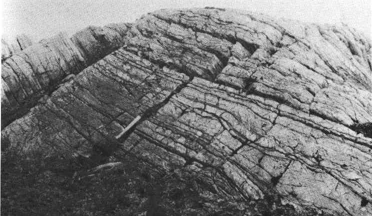
West of Romanet Lake (additional reference section), the Dunphy Formation was divided into four subunits by Chevé (1985). The lower member consists, at the base, of some graphitic black slate overlain by laminated grey to dark grey mudstone and siltstone with lenses (30 cm thick) of grey dolomite having a brown alteration patina. Towards the top, it consists of laminated mudstone and siltstone having a green alteration patina interbedded with centimetric grey dolomite having a brown alteration patina. The upper member of the Dunphy Formation consists mainly of dolomite. At the base, it is represented by massive pink, salmon, beige, grey or white dolomite having a grey or brownish alteration patina, locally sandy. Dolomite contains interbedded purple, green or black mudstone and chert. At the top, it is characterized by massive to laminated pink or salmon stromatolitic dolomite having a white patina, with locally intebedded purple mudstone. The pink colour of dolomite is due to the presence of very finely disseminated hematite in the rock (Dimroth, 1972, 1978; Chevé et al., 1985). The Dunphy dolomite has a characteristic translucent lustre (Dimroth, 1972, 1978). In this area, layers of the Dunphy Formation have been isoclinally folded and refolded.
The rocks of the Dunphy Formation were generally metamorphosed to the greenschist facies (Dimroth and Dressler, 1978; Fraser et al., 1978). Locally, dolomite was ankeritized, particularly in areas where it is highly deformed. The ankeritized rock is yellow in fresh surface and brown in altered patina (Dimroth, 1972, 1978). In places, the Dunphy dolomite has undergone more intense metamorphism. It is represented by a white marble or talc-calcite schist near gabbroic sills of the Wakuach Suite (Montagnais Supersuite) (Dimroth, 1966, 1972, 1978).
The Dunphy Formation was deposited in a coastal or shallow marine shelf environment (Dimroth, 1972, 1978; Chevé et al., 1985). According to Dimroth (1972, 1978), sediments forming the rocks at the eastern and western edges of the formation are thought to have originated in part from continental springs to the east and west of the Trough. The presence of sand grains and hematite dust in dolomite indicates that at least some of the sediments were transported by wind (Dimroth et al., 1970).
The economic potential of the Dunphy Formation lies in lode silver-lead-zinc mineralization, stratiform copper mineralization in sedimentary settings and lode copper mineralization (Clark and Wares, 2004). Laminated to massive dolomites of the Dunphy Formation, formed during the early marine transgression, are of major metallogenic importance for stratiform copper mineralization. The black slate located at the base of the formation, west of Romanet Lake, contains anomalous copper and gold contents (Chevé, 1985; Kish, 1994).
Dunphy Formation, Undivided (pPdy): Dolomite, Stromatolitic Dolomite, Chert, Siltstone, Mudstone, Quartzitic Arenite, Dolomitic Sandstone
This unit consists of pink dolomite and stromatolitic dolomite, chert, siltstone, quartzitic arenite and various dolomitic sandstones.
Dunphy Formation 1 (pPdy1): Mudstone, Siltstone, Slate, Black Slate; Interbedded Dolomite or Quartzitic Arenite
Unit pPdy1 forms the lower member of the Dunphy Formation. It was mapped in the Ronsin Lake (sheet 24B05), Yroquet Lake (sheet 24B03) and Cramolet Lake (sheet 23O13) areas (Dimroth, 1972, 1978; Chevé, 1985). It consists mainly of laminated green or grey to dark grey mudstone, siltstone and slate with interbedded centimetric (~30 cm) grey dolomite having a brown alteration patina or quartzitic arenite (Baragar, 1967; Dimroth, 1972, 1978; Chevé, 1985). In the Ronsin Lake area, a layer of black graphitic slate forms the base of the unit (Dimroth, 1972, 1978; Chevé, 1985). According to Dimroth (1972, 1978), mudstone and siltstone are similar to those of the Lace Lake Formation. The dark colour of the rocks indicates the existence of reducing conditions during sedimentation (Chevé, 1985).
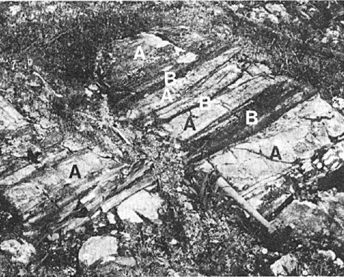
Bedding is generally well preserved in areas of little deformation and is partially or totally lost in the hinges of very tight folds. In places, interbedded dolomite was intensely folded and boudinaged due to the difference in competence with its pelitic host (Chevé, 1985). Numerous rusty brown zones (gossan) of a few decimetres to a few metres in diameter are reported by Chevé (1985). These are formed of pyrite-rich sericite schist which contains chalcocite and malachite locally.
Dunphy Formation 2 (pPdy2): Pink, Salmon, Beige, Grey or White Dolomite, Some Sandstone Locally; Pink or Salmon Stromatolitic Dolomite; Interbedded Chert; Locally Interbedded Mudstone or Siltstone; Marble Locally

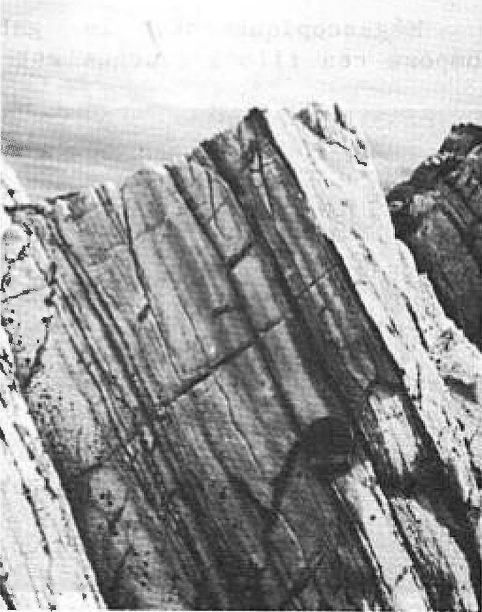
Unit pPdy2 forms the upper member of the Dunphy Formation in the Ronsin Lake area (sheet 24B05) (Dimroth, 1972, 1978; Chevé, 1985). It generally consists of pink, salmon, beige, grey or white dolomite, locally slightly sandy, and pink or salmon stromatolitic dolomite having a white alteration patina. These rocks occur in massive to finely laminated centimetric to metric layers (Dimroth, 1978; Chevé, 1985; Clark, 1986). The Dunphy dolomite has a characteristic translucent lustre (Dimroth, 1972, 1978). The pink or salmon colour of the rock is due to the presence of finely disseminated hematite (Dimroth, 1972, 1978; Clark, 1986). In the Romanet Lake area, Chevé et al. (1985) attribute this pink colour to the oxidation of white dolomite by fluid flow along late fractures. Dolomite contains fine-grained sand near the western margin of the Trough as well as on an island NW of Romanet Lake (Dimroth, 1972, 1978).
Unit pPdy2 also contains interbedded centimetric pink, grey or white chert and interbedded (2-30 cm thick) purple, green or black mudstone locally (Dimroth, 1972, 1978; Clark, 1986). It differs from unit pPdy7 in particular by the absence of sandstone and dolomitic sandstone beds.
In the Canichico Lake area (sheet 24C10) (Dressler, 1979), the Dunphy dolomite has a spotted and banded appearance marked by alternating discontinuous, translucent, white bands (1-10 mm thick) and brownish red bands. Dolomite contains minor amounts of siltstone and quartzitic arenite in the Canichico Lake area and south of latitude 56°N.
Dolomite is locally ankeritized, especially in highly deformed areas south of Ronsin Lake and NE of Otelnuk Lake (Dimroth, 1972, 1978). The rock is honey-yellow in fresh surface, dark brown in altered patina and very coarse grained in places. North of Effiat Lake (sheet 24B04), dolomite is recrystallized to white calcite-actinolite marble at the contact of a gabbro sill (Wakuach Suite). The rock is white to grey, medium grained and highly sheared. It contains stocky actinolite prisms up to 2 cm long (Dimroth, 1966, 1978).
Dunphy Formation 5 (pPdy5): White Quartzitic Arenite with Interbedded Laminated Green to Grey Siltstone
Two occurrences of unit pPdy5 are recognized at the eastern end of the Romanet River, north of Romanet Lake (sheet 24B05). They consist of finely bedded, fine-grained white quartzitic arenite with interbedded laminated green to grey siltstone (Dimroth, 1972, 1978).
Dunphy Formation 7 (pPdy7): Pink, Grey or White Dolomite, Locally Stromatolitic, Locally Ankeritic; Interbedded Chert, Grey Sandstone with Red, Brown or Grey Patina, Dolomitic Sandstone, Sandy Dolomite and Mudstone; Marble Locally
Unit pPdy7 corresponds to the upper member of the Dunphy Formation in places. It was mapped by Dimroth (1969, 1972, 1978) and Clark (1986) in the Mistamisk Lake (sheet 24C08) and Romanet River (sheet 24B05) areas, and by Dimroth (1972, 1978) and Chevé (1984) on the north shore of Dunphy Lake (sheet 24B04). This unit encompasses several features of the Dunphy Formation. It consists mainly of pink, grey or white dolomite having a grey or light pink alteration patina. Dolomite occurs in beds a few millimetres to 1 m thick and is commonly laminated. Laminae are a few centimetres thick and are marked by colour variations. In places, the dolomite is stromatolitic. Columnar stromatolites up to 3 cm wide and 25 cm high were observed locally (Clark, 1986). Dolomite commonly contains interbedded pink, grey or white chert, grey sandstone having red, brown or grey alteration patina, dolomitic sandstone having grey or brown alteration patina, sandy dolomite and laminated purple, green or grey mudstone (Chevé, 1984, Clark, 1986).
Unit pPdy7 is distinguished from unit pPdy2 by the presence of interbedded sandstone and dolomitic sandstone. The dolomite is mainly composed of carbonate, quartz, mica and chlorite. Plagioclase may be present in small amounts locally. The grain size varies from 0.01 to 0.1 mm with lenses and irregular clusters (0.5-1 mm) of quartz-rich material. Micaceous minerals are disseminated and oriented parallel to the latter. The pink colour of dolomite is due to the presence of very finely disseminated hematite (Clark, 1986).
The dolomite is locally ankeritized, particularly in highly deformed areas at the eastern end of the Romanet River. The rock is yellow in fresh surface, brown in altered patina and very coarse grained in places. SE of Mistamisk Lake, dolomite is highly fractured and hematitized due to its proximity to the Bertin Fault. Hematitization has produced variegated beige, salmon, pink and red dolomite (Clark, 1986). Unit pPdy7 dolomite is locally recrystallized to marble, notably at Villandré Lake (sheet 24B05), where it is represented by white phlogopite marble (Dimroth, 1972, 1978). Pinkish white marble was observed at one location only, that is in the Mistamisk Lake and Romanet River area (Clark, 1986).
Dunphy Formation 8 (pPdy8): Calcitic Marble, Calcosilicate Schist
Unit pPdy8 was recognized in the northern part of Otelnuk Lake (sheet 24C08). It consists of calcitic marble and calcosilicate schist.
Dunphy Formation 9 (pPdy9): Basalt, Tuffaceous Basalt
Unit pPdy9 was identified in the northern part of Otelnuk Lake (sheet 24C08). It consists of basalt and tuffaceous basalt.
Thickness and Distribution
The Dunphy Formation belongs to the allochthonous Howse and Romanet (formerly Wheeler) lithotectonic zones, as defined by Clark and Wares (2004). It extends for ~100 km on a NW-SE axis from the Morambert Lake area (sheet 23O14) to Mistamisk Lake. Equivalents of the Dunphy dolomite are recognized as far south as latitude 55°45′N (Dimroth, 1972, 1978) and at Canichico Lake (sheet 24C10) (Dressler, 1973, 1979). The thickness of the Dunphy Formation is not well known. Dimroth (1965, 1970b, 1978, page 67) suggests a thickness ranging from 370 to 610 m. In the area south of Ronsin Lake (additional reference section), Chevé et al. (1985) estimate the thickness of the formation at 430 m. In the Mistamisk Lake and Romanet River area, Clark (1986) estimates the thickness at ≥165 m.
Dating
None.
Stratigraphic Relationship(s)
The deposition of rocks of the Dunphy Formation occurred between 2169 ±2 Ma and 2142 +4/-2 Ma, during the period of deposition of first-cycle sediments (T. Krogh and B. Dressler, unpublished data cited by Clark, 1984, page 4; Rohon et al., 1993; Clark and Wares, 2004). Recently, U-Pb ages of 2166 ±4 Ma and 2171 ±2 Ma were obtained by Corrigan et al. (2020) for the beginning of the first cycle.
The Dunphy Formation conformably overlies the Chakonipau Formation and is conformably overlain by rocks of the Lace Lake Formation (Pistolet Group), which are deeper marine deposits (Dimroth, 1972, 1978; Clark and Wares, 2004). In the area between Ronsin and Romanet lakes, the base of the Dunphy Formation is represented by black slate in sharp contact with the Chakonipau Formation (Dimroth, 1972, 1978; Chevé, 1985). According to Dimroth (1964, 1978), this contact is conformable. However, the interpretation of Chevé (1985) suggests a fault contact between the Dunphy and Chakonipau formations south of Ronsin Lake. To the SE of Mistamisk Lake, a thin basalt unit occurs on top of the Chakonipau Formation, underlying the Dunphy dolomite. However, the contact is not visible (Clark, 1986). In the Mistamisk Lake area, the contact of the Dunphy Formation with the overlying Lace Lake Formation is visible in several places. This contact is gradual and is expressed by interbedded characteristic lithologies of the two units (Clark, 1986). East of Bacon Lake, SE of the type locality, Chevé (1985) indicates that the contact between the Dunphy Dolomite and the Lace Lake Formation is represented by a chert pebble dolomitic conglomerate layer (unit pPll4). South of the Romanet River, the Dunphy Formation is overlain by a quartzitic sandstone unit (pPll4) (Clark, 1986).
In the Du Chambon Lake area, a thrust fault (Du Chambon Fault) juxtaposes the Dunphy Formation and the Alder and Uvé formations (Pistolet Group) (Dimroth, 1978; Clark, 1986). South of the Romanet River, the Dunphy and Lace Lake formations structurally overlie the Romanet Formation (Swampy Bay Group) due to the presence of a major thrust fault (Dimroth, 1978; Clark, 1986). According to Clark (1986), this contact appears to be highly folded. The Dunphy Formation is also in fault contact with basalts and interbedded sedimentary rocks of the Bacchus Formation in the Mistamisk and Romanet lakes valley (Dimroth, 1978; Chevé, 1985; Clark, 1986; Clark and Wares, 2004). Polygenetic intrusive breccia clusters (Mistamisk Complex) were emplaced in the Dunphy Formation SE of Du Chambon Lake (sheet 24C08) (Clark and Wares, 2004; SIGÉOM interactive map).
Paleontology
The dolomites belonging to the Dunphy Formation locally exhibit cryptalgal and algal structures (stromatolites) (Dimroth, 1978; Chevé et al., 1985).
References
Publications Available Through SIGÉOM Examine
CHEVE, S R., 1984. INDICES MINERALISES DU LAC DUNPHY - FOSSE DU LABRADOR. MRN; DP-84-01DP-84-01, 18 pages, 1 plan.
CHEVE, S R., 1985. LES INDICES MINERALISES DU LAC ROMANET, FOSSE DU LABRADOR. I N R S-GEORESSOURCES; ET 83-13, 62 pages, 2 plans.
CLARK, T., 1984. GEOLOGIE DE LA REGION DU LAC CAMBRIEN - TERRITOIRE DU NOUVEAU-QUEBEC. MRN; ET 83-02, 77 pages, 1 plan.
CLARK, T., 1986. GEOLOGIE ET MINERALISATIONS DE LA REGION DU LAC MISTAMISK ET DE LA RIVIERE ROMANET. MRN; ET 83-22, 56 pages, 1 plan.
CLARK, T., WARES, R., 2004. SYNTHESE LITHOTECTONIQUE ET METALLOGENIQUE DE L'OROGENE DU NOUVEAU-QUEBEC (FOSSE DU LABRADOR). MRNFP; MM 2004-01, 182 pages, 1 plan.
CORRIGAN, D., SAPPIN, A.-A., HOULÉ, M.G., RAYNER, N., VAN ROOYEN, D. 2020. Corrugated Hills : les restes d’une grande province ignée d’environ 2,17 Ga dans la Fosse du Labrador. In Résumés des conférences et des photoprésentations, Québec Mines+Énergie 2019. MERN; DV 2019-01, 78 pages.
DIMROTH, E., 1964. GEOLOGIE DE LA REGION DU LAC ROMANET, NOUVEAU-QUEBEC. MRN; RP 523, 20 pages, 1 plan.
DIMROTH, E., 1964. PRELIMINARY REPORT, GEOLOGY OF ROMANET LAKE AREA, NEW QUEBEC. MRN; RP 523(A), 18 pages, 1 plan.
DIMROTH, E., 1965. GEOLOGIE DE LA REGION DU LAC OTELNUK, TERRITOIRE DU NOUVEAU-QUEBEC. MRN; RP 532, 30 pages, 1 plan.
DIMROTH, E., 1965. PRELIMINARY REPORT, GEOLOGY OF OTELNUK LAKE AREA, NEW QUEBEC TERRITORY. MRN; RP 532(A), 27 pages, 1 plan.
DIMROTH, E., 1966. GEOLOGIE DE LA REGION DU LAC DUNPHY, TERRITOIRE DU NOUVEAU-QUEBEC. MRN; RP 557, 24 pages, 1 plan.
DIMROTH, E., 1966. PRELIMINARY REPORT, GEOLOGY OF DUNPHY LAKE AREA, NEW QUEBEC TERRITORY. MRN; RP 557(A), 21 pages, 1 plan.
DIMROTH, E., 1969. GEOLOGIE DE LA REGION DU LAC CASTIGNON, TERRITOIRE DU NOUVEAU-QUEBEC. MRN; RP 571, 62 pages, 7 plans.
DIMROTH, E., 1969. PRELIMINARY REPORT, GEOLOGY OF THE CASTIGNON LAKE AREA, NEW QUEBEC TERRITORY. MRN; RP 571(A), 58 pages, 7 plans.
DIMROTH, E., 1970. CARTES GEOLOGIQUES DU LAC ROMANET ET DU LAC CRAMOLET (FOSSE DU LABRADOR). MRN; DP 068, 3 plans.
DIMROTH, E., 1972. STRATIGRAPHY OF PART OF THE CENTRAL LABRADOR TROUGH. MRN; DP 154, 304 pages, 6 plans.
DIMROTH, E., 1978. Région de la fosse du Labrador entre les latitudes 54° 30' et 56° 30'. MRN; RG 193, 417 pages, 16 plans.
DRESSLER, B., 1973. GEOLOGIE DE LA REGION DU LAC PATU, TERRITOIRE DU NOUVEAU-QUEBEC. MRN; RP 603, 26 pages, 1 plan.
DRESSLER, B., CIESIELSKI, A., 1979. Région de la fosse du Labrador. MRN; RG 195, 136 pages, 14 plans.
KISH, L., 1994. SHALES NOIRS DANS LA FOSSE DU LABRADOR, QUEBEC. MRN; MB 94-43, 16 pages.
KISH, L., TREMBLAY-CLARK, P., 1978. GEOCHIMIE ET RADIOACTIVITE DANS LA FOSSE DU LABRADOR. MRN; DPV 567, 73 pages.
KISH, L., TREMBLAY-CLARK, P., 1979. GEOCHIMIE ET RADIOACTIVITE DANS LA FOSSE DU LABRADOR. MRN; DPV 666, 33 pages.
MERN, 2020. Résumés des conférences et des photoprésentations, Québec Mines+Énergie 2019. DV 2019-01, 78 pages.
Other Publications
BARAGAR, W.R.A. 1967. Wakuach Lake map-area, Quebec-Labrador (23O). Geological Survey of Canada; Memoir 344, 174 pages. https://doi.org/10.4095/123960
CHEVÉ, S.R., SCHRIJVER, K., TASSÉ, N. 1985. Cryptalgalaminate dolomite of the Dunphy Formation, Labrador Trough: diagenetic and tectono-metamorphic evolution related to copper mineralization. Canadian Journal of Earth Sciences; volume 22, pages 1835-1857. https://doi.org/10.1139/e85-195
DIMROTH, E. 1968. The evolution of the central segment of the Labrador geosyncline; part I: stratigraphy, facies and paleogeography; Neues Jahrbuch für Geologie und Paläontologie; volume 132, pages 22-54.
DIMROTH, E. 1970b. Evolution of the Labrador Geosyncline. Geological Society of America Bulletin; volume 81, pages 2717-2742. https://doi.org/10.1130/0016-7606(1970)81[2717:EOTLG]2.0.CO;2
DIMROTH, E., DRESSLER, B. 1978. Metamorphism of the Labrador Trough. In Metamorphism in the Canadian Shield. Geological Survey of Canada; Paper 78-10, pages 215-236. https://doi.org/10.4095/104534
DIMROTH, E., BARAGAR, W.R.A., BERGERON, R., JACKSON, GD. 1970. The filling of the Circum-Ungava geosyncline. In Symposium on Basins and Geosynclines of the Canadian Shield (A.J. Baer, editor). Geological Survey of Canada; Paper 70-40, pages 45-142. https://doi.org/10.4095/124922
FRASER, J.A., HEYWOOD, W.W., MAZURSKI, M.A. 1978. Carte métamorphique du Bouclier Canadien. Geological Survey of Canada; Map 1475A. https://doi.org/10.4095/133909
KISH, L., CUNEY, M. 1981. Uraninite-albite veins from the Mistamisk valley of the Labrador Trough, Quebec. Mineralogical Magazine, volume 44, pages 471-483.
ROHON, M.-L., VIALETTE, Y., CLARK, T., ROGER, G., OHNENSTETTER, D., VIDAL, P. 1993. Aphebian mafic-ultramafic magmatism in the Labrador Trough (New Quebec): its age and the nature of its mantle source. Canadian Journal of Earth Sciences; volume 30, pages 1582-1593. https://doi.org/10.1139/e93-136
ROSCOE, S.M. 1957. Cambrian Lake (east half), New Quebec. Commission géologique du Canada; Études 57-6, 13 pages. https://doi.org/10.4095/101318
SCHRIJVER, K., BERTRAND, R., CHAGNON, A., TASSÉ, N., CHEVÉ, S.R. 1986. Fluids in cupriferous dolostones and dolomite veins, Proterozoic Dunphy Formation, Labrador Trough. Canadian Journal of Earth Sciences; volume 23, pages 1709-1723. https://doi.org/10.1139/e86-158
Suggested Citation
Ministère de l’Énergie et des Ressources naturelles (MERN). Dunphy Formation. Quebec Stratigraphic Lexicon. https://gq.mines.gouv.qc.ca/lexique-stratigraphique/province-de-churchill/formation-de-dunphy_en [accessed on Day Month Year].
Contributors
|
First publication |
Charles St-Hilaire, GIT, M.Sc. charles.st-hilaire@mern.gouv.qc.ca (redaction) Mehdi A. Guemache, P. Geo., Ph.D. (redaction and coordination); anonymous (critical review); Simon Auclair, P. Geo., M.Sc. (editing); Céline Dupuis, P. Geo., Ph.D. (English version); André Tremblay (HTML editing). |