
Geological mapping of a territory as vast as Québec's, with a surface area of nearly 1.7 million km2, is a major challenge, but one that is essential for advancing geological knowledge and stimulating research and mineral exploration. The current geological coverage is the result of the compilation of numerous works carried out mainly by government agencies (provincial and federal) and mining exploration companies. This work, carried out at various scales, has resulted in a relatively complete geological coverage at the regional level. The Geological Map of Québec presented here is the result of the synthesis and homogenization of these different regional geological maps.
Ten years after the 2012 edition, the 1:2 000 000 scale Geological Map of Québec produced by the ministère des Ressources naturelles et des Forêts (MRNF) has been updated. It incorporates the results of numerous geological surveys, compilations and syntheses carried out throughout Québec between 2012 et 2021. The high-resolution magnetic surveys conducted since 2012 have also helped refine the geological interpretation resulting from regional mapping campaigns and compilation work. Similarly, many tools have been added to the Système d’information géominière du Québec (SIGÉOM – Geomining Information System) to archive, compile, improve, correct and enhance Québec's geological data. Since 2012, the Interactive Map, the Geological Bulletin, the Stratigraphic Lexicon, the Structural Lexicon and the Geochronological Files have been added to the SIGÉOM product offering.
As with previous editions, the main objectives of the new Geological Map of Québec are to provide clients with an up-to-date picture of Québec’s geology and to highlight the associated geological data. This new version can be viewed and searched from the Interactive Map, while digital data can be downloaded free of charge from SIGÉOM.
Historical Background
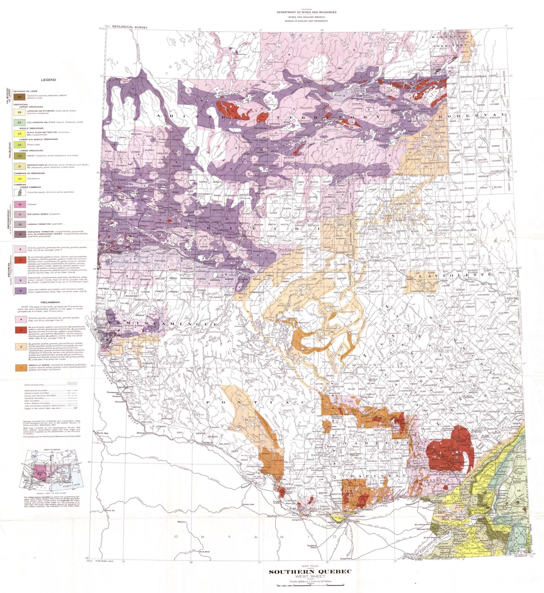
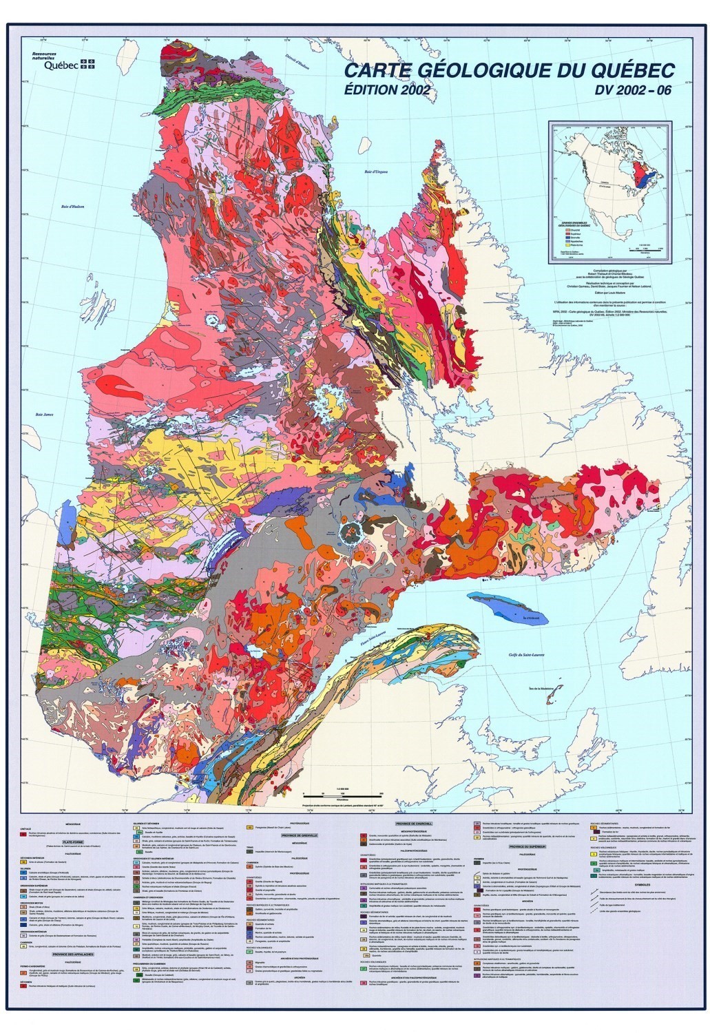
One of the first geological maps of Québec appeared in the document Esquisse géologique et minéraux utiles de la Province de Québec published in 1924 by the ministère de la Colonisation, des Mines et des Pêcheries du Québec at a scale of 100 miles to the inch (1:6 336 000). In this version, which presented the main lines and features of the province's geology, the bedrock rocks were grouped into 13 major geological units (Denis, 1924). In 1941, a series of three maps at a scale of 12 miles to the inch (1:760 320) was produced by the Department of Mines (Dresser and Denis, 1947). A new geological map was published by the Ministry of Mines (1957) along with a report on the mineral resources and industry of Québec. At that time, more than three quarters of the territory had yet to be mapped. Twenty-two years later, in 1979, the ministère de l'Énergie et des Ressources (MER) published a provisional edition of a compilation map at the 1:1 500 000 scale (Avramtchev and Marcoux, 1979). In 1985, the MER published a new map showing the result of the compilation and homogenization of the work carried out over the previous thirty years. In addition to the lithological characteristics, the legend of this map presents the main stratigraphic units of Québec (Avramtchev, 1985). This new information will also appear in subsequent editions. Thériault and Bilodeau (2001) and Thériault (2002) subsequently published two maps that integrated the results of the numerous geological surveys carried out in the meantime. Finally, Thériault and Beauséjour (2012) published an update of the 2002 edition. This new map brings significant improvements in the detail and accuracy of the geology and includes a database that can be used in geographic information systems (GIS).
Evolution of the Geological Map Québec
1924
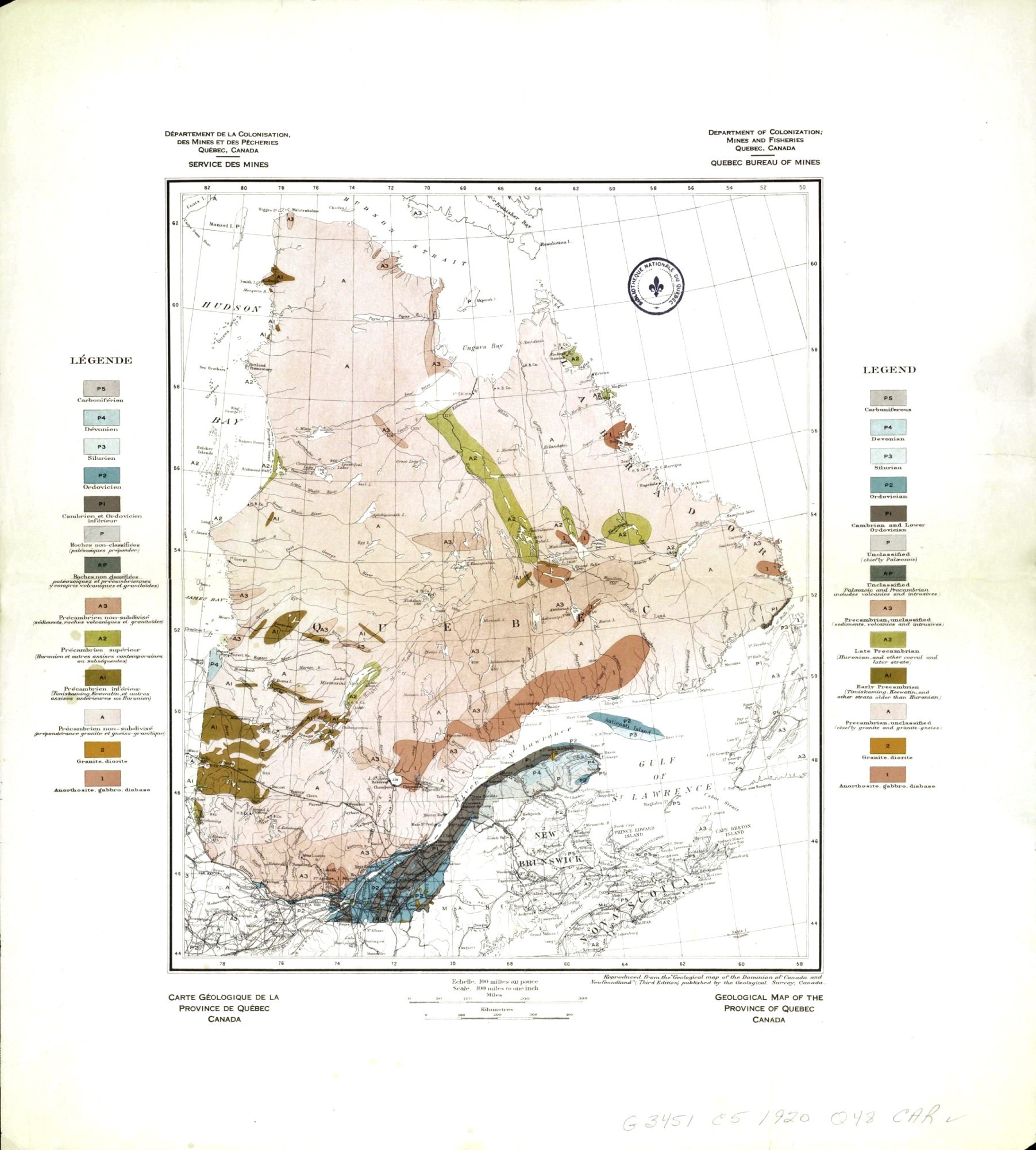
1941
1957

1985
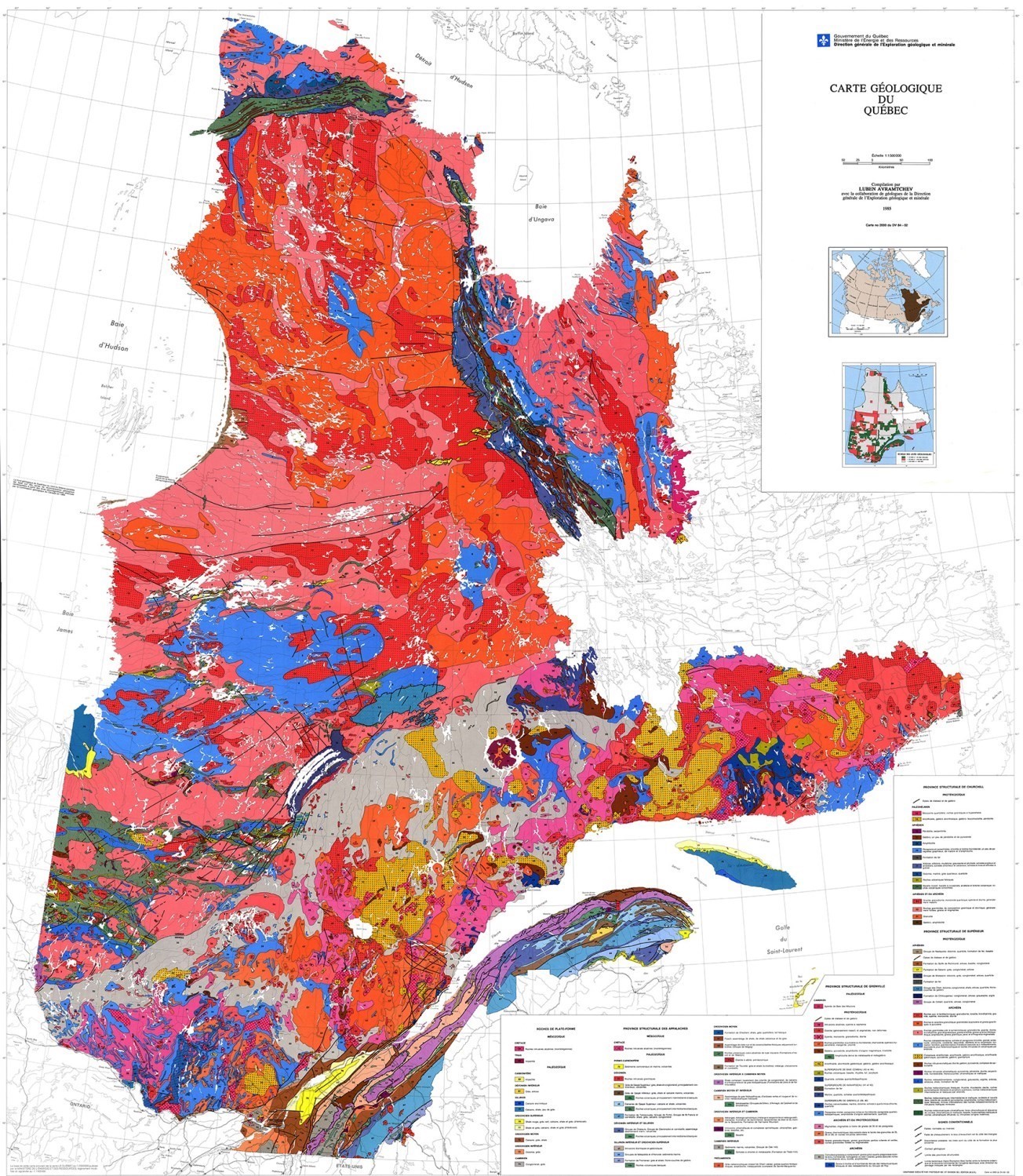
2002
2012

New Features of the 2022 Edition
The main new features of the new geological map of Québec are the following:
- The level of geological detail has been significantly improved in the James Bay area, as well as in the central Grenville Province and in the Churchill Province (central and northwestern parts of the Ungava Orogen, the Labrador Trough and the Southeastern Churchill Province).
- The location of faults and geological zones has been clarified. The position of these features is close to the one observed on a regional scale.
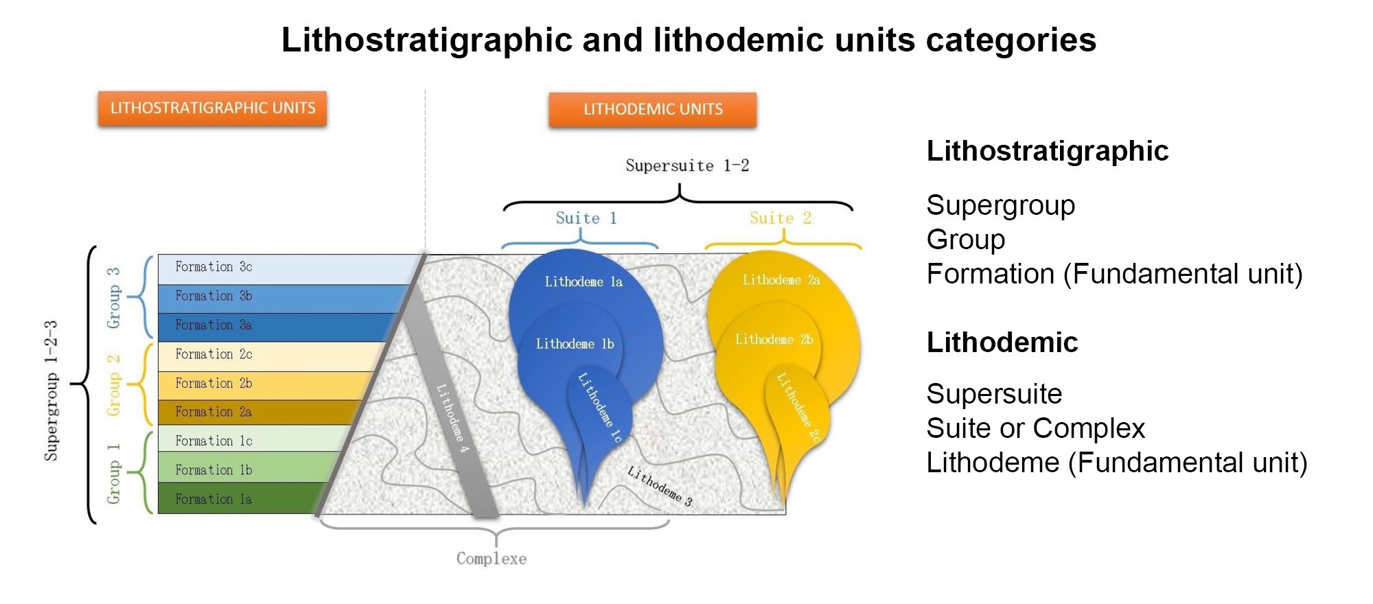
- The database attached to the geological map has been fully integrated into the SIGÉOM architecture. It comprises three layers of information: geological zones, faults and unconformity contacts. For each geological zone, the database includes the lithology, age and name of the associated stratigraphic units. Where appropriate, it also contains the names of related units to which these zones belong (see the "Database" section of this document). For faults, it includes the same information that appears in the regional geology, i.e., the name, type, position and movement of the structure.
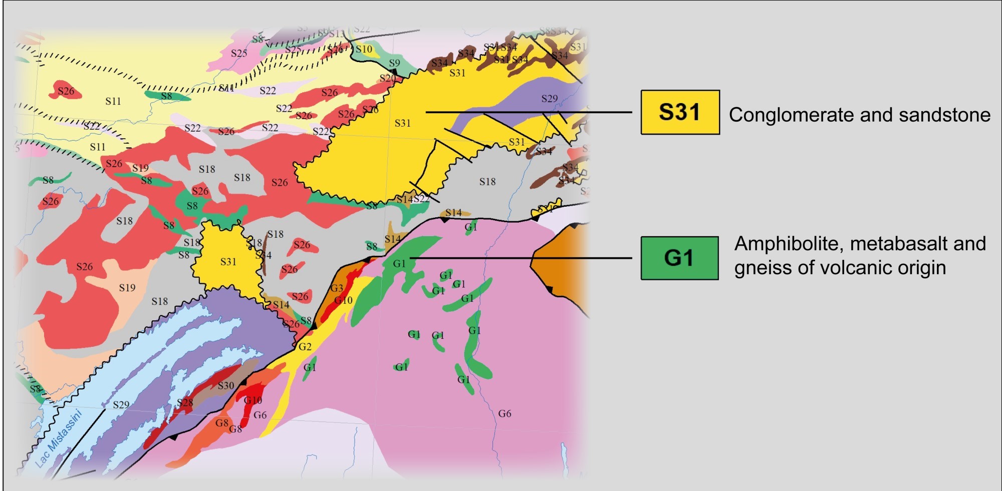
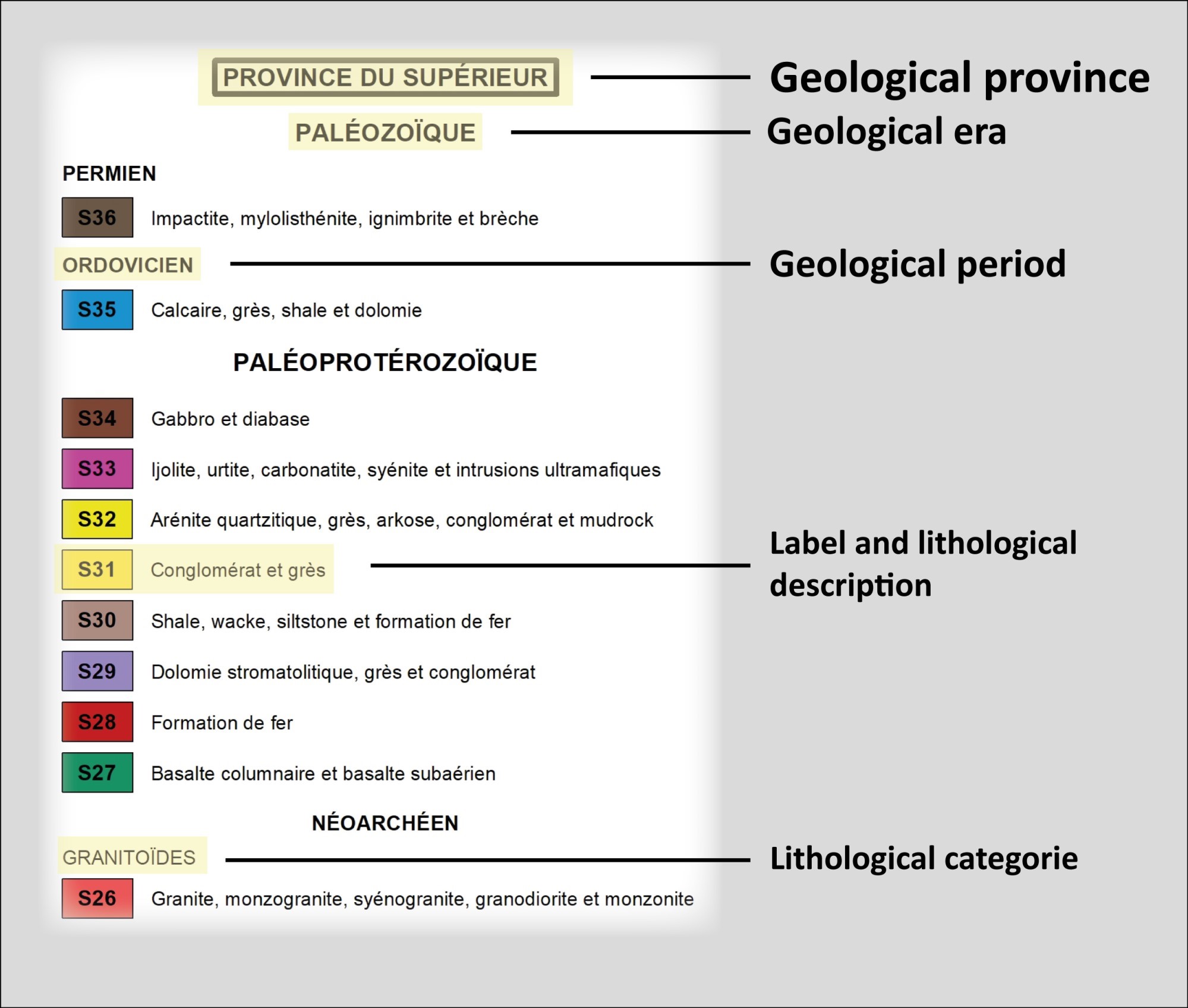
- The geological zone labels are in alphanumeric format as in the previous edition (2012). A letter represents the geological province (M: Monteregian; L: St. Lawrence Platform; H: Hudson Bay Platform; A: Appalachian Province; G: Grenville Province; Su: Southern Province; C: Churchill Province; N: Nain Province; S: Superior Province) followed by a sequential number in descending chronological order.
- The symbolization of geological features is now the same as that used for the regional geology, as presented in the Symboles et abréviations de la carte géoscientifique document (DV 2014-06).
- The geological map can be viewed from the SIGÉOM Interactive Map. Geographic information system (GIS) users can use the WEB mapping services or download the database for free from SIGÉOM.
- The Geological Map of Québec will be updated annually following the publication of geological data from surveys, syntheses or compilation work. The changes will be directly visible on the SIGÉOM Interactive Map.
Revision: Working Method
The compilation and plotting of geological zones, faults and unconformities on the new Geological Map of Québec was carried out digitally using SIGÉOM's geomatic tools. The division into geological zones or units is based mainly on lithological characteristics (rock type), but also on age, the geological province to which these entities belong and current stratigraphic knowledge. The geological data from the regional mapping campaigns and synthesis work carried out by the Ministère since 2012 is the main data source used for updating the map. Geophysical maps were used to extrapolate geological units and faults in areas where geological knowledge was limited and discontinuities in the regional geological coverage remained. The geological areas had to have a minimum size in order to be shown on the map at a scale of 1:2 000 000. Some areas that are too small are therefore not shown on the map, including some small intrusions. The diabase and gabbro dykes have not been plotted in order to facilitate the reading of the map. Each geological zone has been assigned a colour according to its main lithology in accordance with the SIGÉOM colour chart (RGB code) (DV 2014-06).
The geological map also includes the trace of the main faults and shear zones. The primary objective of this exercise was to present a broad picture of basement deformation in brittle and ductile domains at the province scale. Regional geological maps typically contain numerous faults. Only the most important faults, such as large thrust faults, shear zones and some normal faults, were selected. Over time, many of these faults have been named and described in reports. Most of these structures appear on the new geological map. Some fault traces have been extrapolated with the help of geophysics, while others stop abruptly due to the limitations of current geological knowledge. Finally, the unconformities are mainly derived from the regional-scale geological maps and have been adapted to the geological zones of the map.
The descriptive digital data of the geological map were compiled and entered in three separate layers (or attribute tables). The physical structure of the data is described in the "Database" section of this document, which includes several examples that facilitate the use and understanding of the data.
Features of the Geological Map of Québec

Image of the Geological Map
The image of the Geological Map of Québec includes several information elements: geological units, geological subdivisions, legend, metadata, scale and additional information. The image is distributed in PDF format and includes several layers that group together the various components of the map (geological zones, faults, unconformity, hydrography, etc.). These layers can be displayed or hidden in the "Layers" section of the "Browser Pane" of Adobe Acrobat Reader©.
Geological Units
Each geological map unit is identified by a colour according to its main lithology (DV 2014-06) and by a label that refers to the legend.
Legend
The geological map legend is divided into major geological units (or geological provinces). Each province is subdivided into geological eras and periods within which the different geological units are grouped. Each unit is identified by a letter representing the geological province, followed by a sequential number in descending chronological order. In some geological provinces, the geological units are also grouped into different lithological categories.
Main Geological Units of Québec
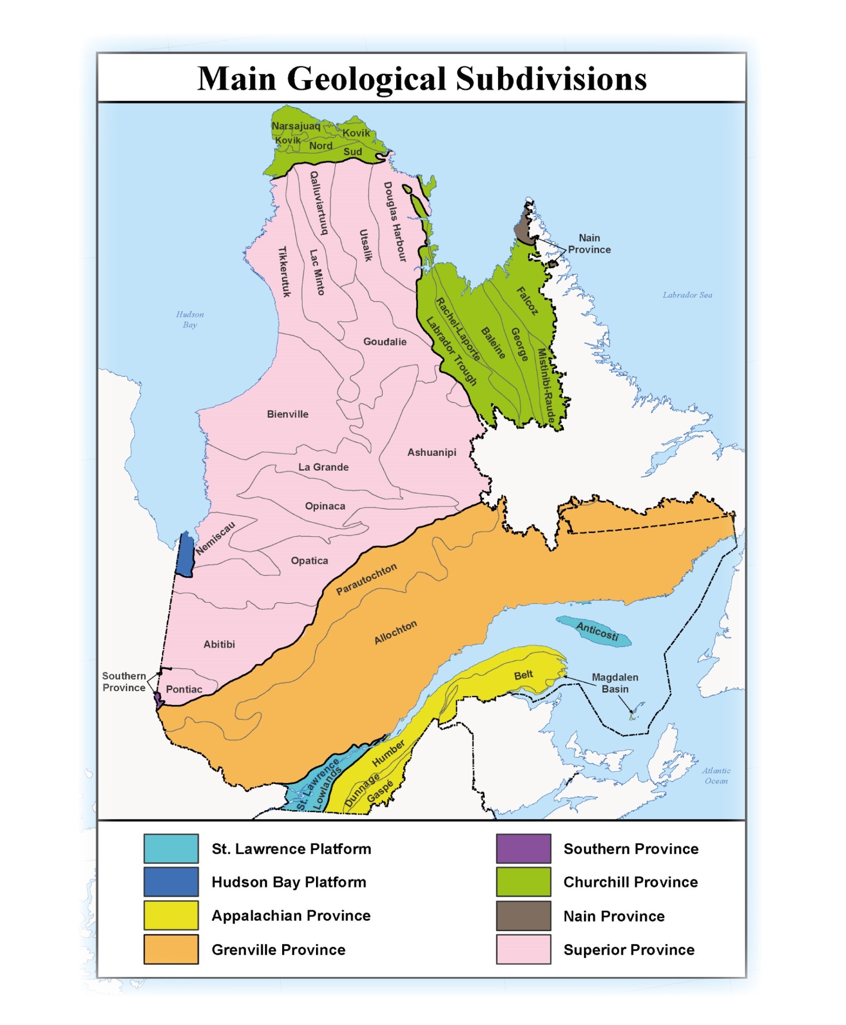
The geology of Québec is divided into nine major geological units or provinces:
- Monteregian intrusions (not shown in the title block);
- St. Lawrence Platform;
- Hudson Bay Platform;
- Appalachian Province;
- Grenville Province;
- Southern Province;
- Churchill Province;
- Nain Province;
- Superior Province.
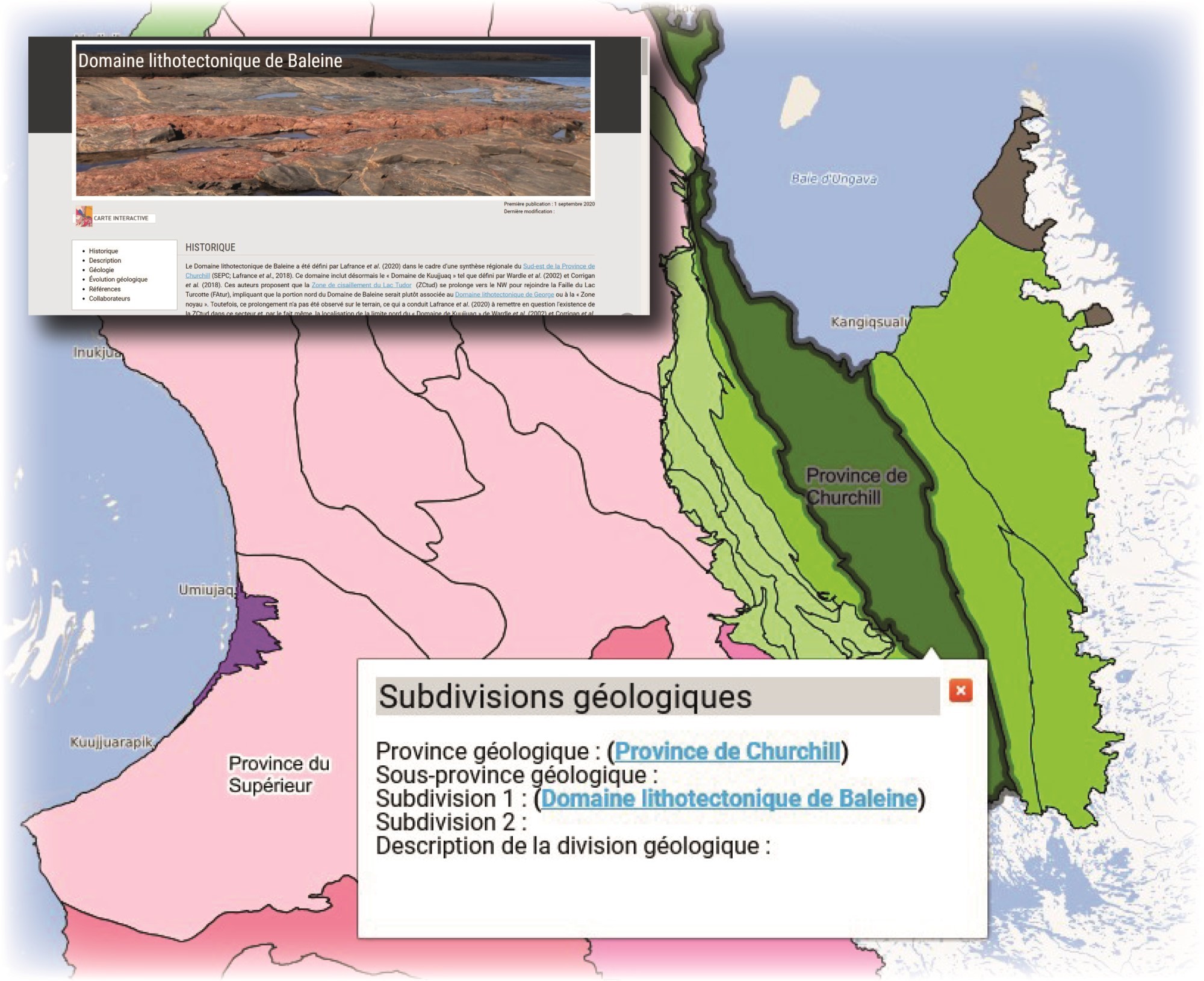 The position of the geological provinces and their main subdivisions can also be displayed on the SIGÉOM Interactive Map. This map allows you to display the boundaries more precisely and to obtain additional information by consulting the descriptive sheets available by clicking on the hyperlinks.
Database
The Geological Map of Québec database is composed of three layers or attribute tables:
- Geological zone;
- Fault;
- Contact (unconformity only).
Nomenclature and Physical Structure of Attribute Tables (FGDB)
| Name (alias) | Feature Dataset | Feature Class | Geometry |
|---|---|---|---|
| General Geological Zone | SIGEOMclass | SGM_ZONE_GEOLO_QC_SO | Polygon |
| General Fault | N/A | SGM_FAILL_REGIO_QC_LO | Line |
| GGeneral Geological Contact | N/A | SGM_CONTA_GEOLO_QC_LO | Line |
| Field Name | Description | Example |
|---|---|---|
| Legend | ||
| ZGQ_VAL_ORDRE_LEGEN | Order (or position) of the label in the legend. Allows you to sort the labels in the same order as shown in the map legend. The labels are numbered from 1 to 915 with a jump of 5 between them | 1, 5, 30, 55, 775, etc. |
| ZGQ_CODE_IDENT_ETIQU_LEGEN | Alphanumeric label identifying the geological unit. The letter identifying the geological province is followed by a sequential number in descending chronological order | L4, H3, A2, G10, etc. |
| CODE_SYMBL | Code used to symbolize the polygon. The code corresponds to a colour assigned to each unit in the legend according to its main lithology. See the colour chart in document DV 2014-06 for more details | geo141 |
| Lithology | ||
| ZGQ_DESCR | Lithological description (rock types) of the geological zone. This description is specific to the geological zone and is complementary to the description found in the map legend (example) | Tonalitic, granitic, dioritic and monzodioritic gneiss |
| ZGQ_DESCR_ANGLA | English version of the lithological description | Tonalitic, granitic, dioritic and monzodioritic gneiss |
| Stratigraphy | ||
| ZGQ_CODE_SUPER_STRAT |
Stratigraphic code indicating the age and name, where known, of a supergroup or supersuite |
|
| ZGQ_CODE_SUITE_GROUP_STRAT |
Stratigraphic code indicating the age and name, where known, of a group, suite or complex |
Example 1 Example 2 |
| CODE_ETIQU_STRAT_1 |
Stratigraphic code indicating the age and name of a formation or lithodeme |
|
|
When the formation or lithodeme is part of a group, suite or complex, the name of the higher rank unit is given in the previous field (ZGQ_CODE_SUITE_GROUP_STRAT) |
||
|
Geological age code used alone in the case of a lithological (not stratigraphic) unit (see ZGQ_CODE_REPRE field) |
||
|
Stratigraphic code indicating the age and name of a group, suite or complex in cases where the zone represents a grouping of two stratigraphic units of equal rank |
||
| ZGQ_CODE_ETIQU_STRAT_2 |
Stratigraphic code indicating the age and name of a formation or lithodemes where the zone represents a combination of two stratigraphic units of equal rank |
|
|
When formations or lithodemes are part of a group, suite or complex, the name of the higher rank unit is given in the ZGQ_CODE_SUITE_GROUP_STRAT field |
||
|
Stratigraphic code indicating the age and name of a group, suite or complex where the zone represents a grouping of three stratigraphic units of equal rank |
||
| ZGQ_CODE_ETIQU_STRAT_3 |
Stratigraphic code indicating the age and name of a formation or lithodeme where the zone represents a grouping of three stratigraphic units of equal rank |
|
|
When formations or lithodemes are part of a group, suite or complex, the name of the higher rank unit is given in the ZGQ_CODE_SUITE_GROUP_STRAT field |
||
|
Stratigraphic code indicating the age and name of a group, suite or complex where the zone represents a grouping of four stratigraphic units of equal rank |
||
| Additional Information | ||
| ZGQ_CODE_REPRE |
Code indicating whether the area is stratigraphic (stratigraphy is known) or lithological (stratigraphy is unknown and only an age code is given in the CODE_ETIQU_STRAT_1 field) Value Domain:
|
STR or Stratigraphic |
| ZGQ_COM | Comment (to add additional information if necessary) | Upper Eastmain Greenstone Belt (UEGB) |
| Other fields found in the table are system attributes or for internal use. They are part of the common architecture of the SIGÉOM attribute tables. | ||
| Field Name | Description | Example |
|---|---|---|
| FRQ_CODE_TYPE | Fault Type
Value Domain:
|
F or Fault |
| FRQ_CODE_POSIT | Fault Movement
Value Domain:
|
C or Definite |
| FRQ_CODE_MOUVE | Fault Movement
Value Domain:
|
IV or Reverse |
| FRQ_NOM | Fault name | Aiguebelle Fault |
| FRQ_NOM_ANGLA | Fault name (English) | Aiguebelle Fault |
| CODE_SYMBL |
Code used for the symbolization of the fault The symbolization code consists of the concatenation of the type (FRQ_CODE_TYPE), position (FRQ_CODE_POSIT) and movement of the fault (FRQ_CODE_MOUVE) codes |
FCIV Can be translated as follows: definite fault with reverse movement |
| FRQ_COM | Comment (to add additional information if necessary) | Late movement fault |
| Other fields found in the table are system attributes or for internal use. They are part of the common architecture of the SIGÉOM attribute tables. | ||
| Field Name | Description | Example |
|---|---|---|
| CGQ_CODE_TYPE | Type of geological contact
Value Domain:
|
DI or Unconformity N.B. Only the unconformities have been plotted on the Geological Map of Québec |
| CODE_SYMBL | Code used for the symbolization of the unconformity | CGDC |
| CGQ_NOM | Geological contact name | Field not used in the Geological Map of Québec |
| CGQ_COM | Comment | Field not used in the Geological Map of Québec |
| Other fields found in the table are system attributes or for internal use. They are part of the common architecture of the SIGÉOM attribute tables. | ||
Data files are in FGDB format (geodatabase file) from ESRI. The data are also available in Shapefile (SHP) and Geopackage (GPKG) formats. These data are available in the VECTOR DATA AND WEB SERVICES section of SIGÉOM. Data downloading is free of charge and does not require authentication. The data can also be viewed and consulted from the Interactive Map and Web mapping services. The SIGÉOM data are recorded in geographical coordinates in the NAD83 geodetic reference system based on the GRS80 ellipsoid.
Ghyslain Roy, P.geo (writing and geological compilation)
This new edition of the Geological Map of Québec is above all the result of the collaboration of all the field geologists of the ministère des Ressources naturelles et des Forêts du Québec (MRNF) who have taken part in geological surveys since 2012. As shown by their numerous works cited in the references, they are the main architects of the improvement of the geological knowledge of the Québec territory. In particular, the contribution of Daniel Bandyayera, Isabelle Lafrance and Abdelali Moukhsil are worth mentioning with regard to the revision of the geological content included in the map and legend of the Superior Province (James Bay), the Churchill Province and the central Grenville Province. We would also like to acknowledge the contribution of Claude Dion for the linguistic revision and critical reading, Kathleen O'Brien for her precious help with the technical aspects of the map, Caroline Thorn and André Tremblay for the WEB support and graphics and Simon Auclair for the translation.
AVRAMTCHEV, L., 1985. Carte géologique du Québec. MRN; DV 84-02, 2 plans.
AVRAMTCHEV, L., MARCOUX, P., 1979. Carte géologique du Québec – Édition provisoire. MER; DP 735, 1 plan.
BANDYAYERA, D., CARON-CÔTÉ, E., 2019. Géologie de la région du lac des Montagnes, sous-provinces de La Grande, de Nemiscau et d'Opatica, Eeyou Istchee Baie-James, Québec, Canada. MERN; BG 2019-03, 1 plan.
BANDYAYERA, D., CARON-CÔTÉ, E., 2021. Géologie de la région du lac Le Vilin, sous-provinces de La Grande et d'Opatica, Eeyou Istchee Baie-James, Québec, Canada. MERN; BG 2022-03, 1 plan.
BANDYAYERA, D., CARON-CÔTÉ, E., PEDREIRA PÉREZ, R., CÔTÉ-ROBERGE, M., CHARTIER-MONTREUIL, W., 2022. Synthèse géologique de la Sous-province de Nemiscau, Eeyou Istchee Baie-James, Québec, Canada. MERN; BG 2021-03, 1 plan.
BANDYAYERA, D., DAOUDENE, Y., 2017. Géologie de la région du lac Rodayer (SNRC 32K13-32K14-32N03 et 32N04-SE). MERN; RG 2017-01, 60 pages, 2 plans.
BANDYAYERA, D., DAOUDENE, Y., 2018. Géologie de la région du lac Champion, sous-provinces de La Grande et de Nemiscau, à l'est de Waskaganish, Eeyou Istchee Baie-James, Québec, Canada. MERN; BG 2018-06, 2 plans.
BANDYAYERA, D., DAOUDENE, Y., 2019. Géologie de la région du lac Nemiscau, secteur ouest de la rivière Rupert (SNRC 32N06, 32N07 et 32N11). MERN; RG 2018-03, 58 pages, 1 plan.
BEAUCHAMP, A. M., 2020. Géologie de la région du lac Cadieux, sous-provinces d'Opatica et d'Opinaca, Eeyou Istchee Baie-James, Québec, Canada. MERN; BG 2019-02, 2 plans.
BEAUCHAMP, A. M., MASSEI, F., DAOUDENE, Y., 2018. Géologie de la région de l'île Bohier, au contact entre les sous-provinces d'Opatica, d'Opinaca et le bassin d'Otish, au nord de Mistissini, Eeyou Istchee Baie-James, Québec, Canada. MERN; BG 2018-02, 2 plans.
BEAUDETTE, M., BILODEAU, C., MATHIEU, G., 2020. Géologie de la région du lac Parent, Orogène de l'Ungava, Nunavik, Québec, Canada. MERN; BG 2020-04, 1 plan.
BILODEAU, C., 2018. Géologie de la partie nord du Domaine de Rachel-Laporte, région de Kuujjuaq, Nunavik, Québec, Canada. MERN; CG-2018-07
BILODEAU, C., 2022. Géologie de la région de l'Île-du-Grand-Calumet, Province de Grenville, Outaouais, Québec, Canada. MERN; BG 2022-07, 1 plan.
BILODEAU, C., CARON-CÔTÉ, E., 2018. Géologie de la région de la rivière Arnaud, provinces du Supérieur (Minto) et de Churchill (Fosse du Labrador), secteur de Kangirsuk, Nunavik, Québec, Canada. MERN; BG 2018-04, 2 plans.
CHARETTE, B., BEAUDETTE, M., 2018. Géologie de la région du cap Wolstenholme, Orogène de l'Ungava, Province de Churchill, sud-est d'Ivujivik, Québec, Canada. MERN; BG 2018-03, 2 plans.
CHARETTE, B., LAFRANCE, I., MATHIEU, G., 2016. Géologie de la région du lac Jeannin, Québec, Canada. MERN; BG 2015-01, 1 plan.
CHARETTE, B., LAFRANCE, I., VANIER, M.-A., 2018. Domaine lithotectonique de George, sud-est de la Province de Churchill, Nunavik, Québec, Canada : synthèse de la géologie. MERN; BG 2018-11, 2 plans.
CHARETTE, B., LAFRANCE, I., VANIER, M.-A., GODET, A., 2019. Domaine lithotectonique de Mistinibi-Raude, sud-est de la Province de Churchill, Nunavik, Québec, Canada : synthèse de la géologie. MERN; BG 2019-07, 2 plans.
CLARK, T., 2021. Révision des cartes géologiques de la Fosse du Labrador à l'aide de cartes géophysiques à haute résolution et nouveau modèle paléogéographique-tectonique de sa partie centrale. MERN; ET 2021-02, 77 pages.
CÔTÉ-ROBERGE, M., CHARTIER-MONTREUIL, W., HAMEL-HÉBERT, M.-K., BANDYAYERA, D., 2021. Géologie de la région du lac Conviac, sous-provinces d'Opinaca et de La Grande, Eeyou Istchee Baie-James, Québec, Canada. MERN; BG 2022-05, 1 plan.
CÔTÉ-ROBERGE, M., GOUTIER, J., 2019. Géologie de la région du lac Casterne, sous-provinces de La Grande et d'Opinaca, Eeyou Istchee Baie-James, Québec, Canada. MERN; BG 2019-05, 2 plans.
DAOUDENE, Y., BEAUDETTE, M., 2021. Géologie de la région du lac La Trêve, Sous-province d'Abitibi, Eeyou Istchee Baie-James, Québec, Canada. MERN; BG 2022-04, 1 plan.
DENIS, T.C., 1924. Esquisse géologique et minéraux utiles de la Province de Québec.. MRN; AP 1924-01, 73 pages, 2 plans.
DENIS, T.C., DRESSER, J.A., 1946. La géologie de Québec volume II, géologie descriptive. MRN; RG 020-II, 730 pages, 4 plans.
DESCHÊNES, P.-L., ALLARD, G., GUEMACHE, M.A., 2015. Révision de la géologie de la région de la rivière Wawagosic (parties des SNRC 32D15 et 32E02).. MERN; RP 2014-04, 22 pages.
DE SOUZA, S., TREMBLAY, A., 2012. Compilation géologique des Appalaches et des Basses-Terres du Saint-Laurent, régions administratives de Chaudière-Appalaches, Capitale-Nationale et Bas-Saint-Laurent. UQAM; MB 2012-06, 5 pages, 22 plans.
EL BOURKI, M., MOUKHSIL, A., 2021. Géologie de la région de Dolbeau-Blondelas, Province de Grenville, région du Saguenay-Lac-Saint-Jean, Québec, Canada. MERN; BG 2022-02, 1 plan.
GIGON, J., GOUTIER, J., 2017. Géologie de la région du lac Richardie, municipalité d'Eeyou Istchee Baie-James. MERN; RG 2016-04, 45 pages, 2 plans.
GIGON, J., GOUTIER, J., CÔTÉ-ROBERGE, M., 2020. Géologie de la région du lac de Villaret (SNRC 33F01 et 33F08), municipalité d'Eeyou Istchee Baie-James. MERN; RG 2019-01, 42 pages, 1 plan.
GOUTIER, J., 2018. Géologie de la région du lac Ewart, sous-provinces de La Grande et d'Opinaca, à l'est de Radisson, Eeyou Istchee Baie-James, Québec, Canada. MERN; BG 2018-10, 2 plans.
GOUTIER, J., GIGON, J., 2016. Géologie – Région du lac Sakami. MERN; CG-2016-05, 1 plan.
GOUTIER, J., GIGON, J., BURNIAUX, P., DION, C., TALLA TAKAM, F., CHARTIER-MONTREUIL, W., BANDYAYERA, D., 2021. Géologie de la région du lac de la Corvette, Eeyou Istchee Baie-James. MERN; RG 2020-01, 69 pages, 1 plan.
GROULIER, P.-A., INDARES, A., DUNNING, G., MOUKHSIL, A., 2015. Géologie de la ceinture volcano-sédimentaire des Escoumins, Côte-Nord, Québec (rapport préliminaire).. MERN, Memorial University of Newfoundland and Labrador; MB 2015-09, 82 pages.
GROULIER, P.-A., INDARES, A., DUNNING, G., MOUKHSIL, A., 2016. Géologie de la ceinture volcano-sédimentaire des Escoumins, Côte-Nord, Québec.. MERN, Memorial University of Newfoundland and Labrador; MB 2016-07, 87 pages.
GUEMACHE, M.A., 2020. Synthèse géologique de la région de rivière Octave, Abitibi. MERN; RG 2018-01, 68 pages, 1 plan.
HAMMOUCHE, H., 2017. Géologie de la région du lac Cuvillier, Abitibi Nord-Est (32C15). MERN; RG 2016-02, 38 pages, 1 plan.
HAMMOUCHE, H., BURNIAUX, P., 2018. Géologie de la région du lac Joubert (SNRC 23E03, 23E04, 33H01), municipalité d'Eeyou Istchee Baie-James. MERN; RG 2018-04, 53 pages.
HAMMOUCHE, H., BURNIAUX, P., KHARIS, A.A., 2015. Géologie de la région du lac Carmoy, Baie-James.. MERN; RG 2015-02, 44 pages, 3 plans.
HAMMOUCHE, H., BURNIAUX, P., KHARIS, A.A., 2017. Géologie de la région du lac des Vœux (SNRC 33H10, 33H15 et 33H16), municipalité d’Eeyou Istchee Baie-James.. MERN, UQAT; RG 2016-01, 39 pages, 1 plan.
LAFRANCE, I., BANDYAYERA, D., BILODEAU, C., 2015. Géologie de la région du lac Henrietta (SNRC 24H). MERN; RG 2015-01, 62 pages, 1 plan.
LAFRANCE, I., CHARETTE, B., VANIER, M.-A., 2018. Sud-est de la Province de Churchill, Nunavik, Québec, Canada: synthèse de la géologie. MERN; BG 2018-12
LAFRANCE, I., SIMARD, M., BANDYAYERA, D., 2014. Géologie de la région du lac Saffray (SNRC 24F, 24G). MRN; RG 2014-02, 51 pages, 1 plan.
LAFRANCE, I., VANIER, M.-A., 2021. Domaine lithotectonique de Rachel-Laporte, sud-est de la Province de Churchill, Nunavik, Québec, Canada: synthèse de la géologie. MERN; BG 2021-01, 4 plans.
LAFRANCE, I., VANIER, M.-A., 2022. Domaine lithotectonique de Falcoz, sud-est de la Province de Churchill, Nunavik, Québec, Canada: synthèse de la géologie. MERN; BG 2022-01, 1 plan.
LAFRANCE, I., VANIER, M.-A., CHARETTE, B., 2020. Domaine lithotectonique de Baleine, sud-est de la Province de Churchill, Québec, Canada: synthèse de la géologie. MERN; BG 2020-07, 4 plans.
LECLERC, F., CARON-CÔTÉ, E., 2017. Levé géologique dans la sous-province d'Opatica au nord-est de Matagami (région du lac Amisquioumisca). MERN; BG 2017-01, 2 plans.
LECLERC, F., DAOUDENE, Y., 2021. Géologie de la région du lac des Deux Orignaux, à l'ouest de Chapais, Sous-Province de l'Abitibi, Eeyou Istchee Baie-James, Québec, Canada. MERN; BG 2021-04, 1 plan.
LECLERC, F., TALLA TAKAM, F., 2014. Géologie – Lac Charbonneau.. MERN; CG-32I04D-2014-01, 1 plan.
LECLERC, F., TALLA TAKAM, F., 2014. Géologie – Lac Chevrillon. MERN; CG-32J01A-2014-01, 1 plan.
LECLERC, F., TALLA TAKAM, F., 2014. Géologie – Lac Claude. MERN; CG-32J01C-2014-01, 1 plan.
LECLERC, F., TALLA TAKAM, F., 2014. Géologie – Lac des Canots. MERN; CG-32I04B-2014-01, 1 plan.
LECLERC, F., TALLA TAKAM, F., 2014. Géologie – Lac Lafrance. MERN; CG-32I04A-2014-01, 1 plan.
LECLERC, F., TALLA TAKAM, F., 2014. Géologie – Lac Peter. MERN; CG-32J01D-2014-01, 1 plan.
LECLERC, F., TALLA TAKAM, F., 2014. Géologie – Lac Waconichi. MERN; CG-32I04C-2014-01, 1 plan.
LECLERC, F., TALLA TAKAM, F., 2014. Géologie – Lac Waconichi. MERN; CG-32J01B-2014-01, 1 plan.
LECLERC, F., TALLA TAKAM, F., GUEMACHE, M.A., 2015. Géologie – Lac à l’Eau Jaune. MERN; CG-2015-04, 2 plans.
MASSEI, F., HAMMOUCHE, H., 2016. Géologie – Région du lac Emmanuel. MERN; CG-2016-09, 1 plan.
MATHIEU, G., BEAUDETTE, M., 2019. Géologie de la région du lac Watts, Domaine Nord, Fosse de l'Ungava, Nunavik, Québec, Canada. MERN; BG 2019-04, 1 plan.
MATHIEU, G., BILODEAU, C., 2020. Géologie de la région nord-ouest du réservoir Manicouagan (SNRC 22N06, 22N11, 22N14 et 22N10). MERN; RG 2018-05, 36 pages, 1 plan.
MATHIEU, G., LAFRANCE, I., VANIER, M.-A., 2018. Géologie de la région de pointe Le Droit, Province de Nain et sud-est de la Province de Churchill, Nunavik, Québec, Canada. MERN; BG 2018-07, 4 plans.
MINISTÈRE DES MINES, 1957. Ressources minérales et industries minérales de la Province de Québec. AP 1957-01, 81 pages, 2 plans.
MOUKHSIL, A., CÔTÉ, G., 2017. Géologie de la région de Wemotaci, Haut-Saint-Maurice (partie ouest du Grenville). MERN; RG 2017-03, 44 pages, 2 plans.
MOUKHSIL, A., CÔTÉ, G., 2018. Géologie de la région du lac Borgia, Province de Grenville, nord de La Tuque, régions de la Mauricie et du Saguenay-Lac-St-Jean, Québec, Canada. MERN; BG 2018-01, 2 plans.
MOUKHSIL, A., DAOUDENE, Y., 2019. Géologie de la région du lac des Commissaires, Province de Grenville, région du Saguenay-Lac-Saint-Jean, Québec, Canada. MERN; BG 2019-01, 1 plan.
MOUKHSIL, A., EL BOURKI, M., 2019. Géologie de la région de Normandin, Province de Grenville, région du Saguenay-Lac-Saint-Jean, Québec, Canada. MERN; BG 2020-01, 2 plans.
MOUKHSIL, A., EL BOURKI, M., 2021. Géologie de la région de Girardville, Province de Grenville, région du Saguenay - Lac-Saint-Jean, Québec, Canada. MERN; BG 2021-02, 2 plans.
MOUKHSIL, A., SOLGADI, F., BELKACIM, S., 2016. Géologie de la région de Clova, Haut-Saint-Maurice (partie ouest du Grenville). MERN, URSTM-UQAT; RG 2016-03, 52 pages, 1 plan.
MOUKHSIL, A., SOLGADI, F., BELKACIM, S., AUGLAND, L.E., DAVID, J., 2015. Géologie de la région de Parent, Haut-Saint-Maurice (partie ouest du Grenville). MERN, UQAT-URSTM, GEOTOP-UQAM-MCGILL; RG 2015-04, 62 pages, 1 plan.
MOUKHSIL, A., SOLGADI, F., BELKACIM, S., ELBASBAS, A., AUGLAND, L.E., 2014. Géologie de la région du lac Okaopeo, Côte-Nord. MERN, URSTM-UQAT, GEOTOP UQAM-MCGILL; RG 2014-03, 34 pages, 1 plan.
MOUKHSIL, A., SOLGADI, F., INDARES, A., BELKACIM, S., 2013. Géologie de la région septentrionale du réservoir aux Outardes 4, Côte-Nord. MRN, UQAT, URSTM; RG 2013-03, 33 pages, 1 plan.
MOUKHSIL, A., SOLGADI, F., JANNIN, S., GERVAIS, F., CROWLEY, J.L., AUGLAND, L.E., INDARES, A., LETOURNEAU, M., DUNNING, G., CLARK, T., GOBEIL, A., OHNENSTETTER, D., LAMOTHE, D., INTISSAR, R., BENAHMED, S., GROULIER, P. -A., 2017. Géologie, potentiel minéral et cadre géodynamique des roches de la région du réservoir Daniel-Johnson (Manicouagan), partie centrale de la Province de Grenville. MERN; MM 2017-01, 307 pages, 1 plan
PERROT, M., TREMBLAY, A., 2017. Compilation géologique – Coaticook. UQAM; CG-21E04-2016-01, 2 plans.
PERROT, M., TREMBLAY, A., 2017. Compilation géologique – La Patrie. UQAM; CG-21E06-2016-01, 2 plans.
PERROT, M., TREMBLAY, A., 2017. Compilation géologique – Lac-Mégantic. UQAM; CG-21E10-2016-01, 2 plans.
PERROT, M., TREMBLAY, A., 2017. Compilation géologique – Malvina. UQAM; CG-21E03-2016-01, 1 plan.
PERROT, M., TREMBLAY, A., 2017. Compilation géologique – Sherbrooke. UQAM; CG-21E05-2016-01, 2 plans.
PERROT, M., TREMBLAY, A., 2017. Compilation géologique – Woburn. UQAM; CG-21E07-2016-01, 2 plans.
PERROT, M., TREMBLAY, A., 2017. Compilation géologique – Warwick. UQAM; CG-21E13-2016-01, 2 plans.
PILOTE, P., 2014. Géologie – La Motte. MRN; CG-32D08B-2014-01, 1 plan.
PILOTE, P., 2015. Géologie – La Corne. MERN; CG-32C05A-2015-01, 2 plans.
PILOTE, P., 2015. Géologie – Lac De Montigny. MERN; CG-32C04C-2015-01, 2 plans.
PILOTE, P., DAIGNEAULT, R., MOORHEAD, J., 2018. Géologie de la région de Barraute Ouest, Sous-province de l'Abitibi, région de l'Abitibi-Témiscamingue, Québec, Canada. MERN; BG 2018-05, 2 plans.
PILOTE, P., LACOSTE, P., BEDEAUX, P., 2017. Géologie – Lac Fiedmont. MERN; CG-2016-15, 2 plans.
PILOTE, P., LACOSTE, P., BEDEAUX, P., 2017. Géologie – Val-Senneville. MERN; CG-2016-14, 2 plans.
PILOTE, P., LACOSTE, P., GUEMACHE, M.A., 2017. Géologie – Lac Tiblemont. MERN; CG-2016-10, 2 plans.
PILOTE, P., MARLEAU, J., 2019. Géologie de la région d'Amos, Sous-province de l'Abitibi, région de l'Abitibi-Témiscamingue, Québec, Canada. MERN; BG 2020-06, 1 plan.
PILOTE, P., MARLEAU, J., DAVID, J., 2019. Géologie de la région de Barraute, Sous-province de l'Abitibi, région de l'Abitibi-Témiscamingue, Québec, Canada. MERN; BG 2019-06, 2 plans.
SIMARD, M., PAQUETTE, L., PARENT, M., 2015. Synthèse géologique et métallogénique de la sous-province d'Ashuanipi, Province du Supérieur. MERN; MM 2015-01, 96 pages, 2 plans.
TALLA TAKAM, F., BEAUCHAMP, A.-M., 2016. Géologie – Lac Learn. MERN; CG-2016-08, 1 plan.
THÉRIAULT, R., 2002. Carte géologique du Québec, édition 2002. MRN; DV 2002-06, 8 pages, 1 plan.
THÉRIAULT, R., BEAUSÉJOUR, S., 2012. Carte géologique du Québec - édition 2012. MRN; DV 2012-06, 8 pages, 1 plan.
THÉRIAULT, R., BILODEAU, C. 2002. Carte géologique du Québec, édition 2001. MERN; DV 2001-03, 6 pages, 1 plan.
THÉRIAULT, R., DION, C., 2017. Compilation géologique de la région du lac Biencourt, Bas-Saint-Laurent. MERN; MB 2017-01, 20 pages, 1 plan.
THÉRIAULT, R., DION, C., 2017. Compilation géologique de la région du lac Etchemin. MERN; MB 2017-02, 10 pages, 1 plan.
THÉRIAULT, R., DION, C., ST-HILAIRE, C., 2016. Compilation géologique de la région du lac Mitis, Bas-Saint-Laurent. MERN; MB 2016-18, 21 pages, 1 plan.
TREMBLAY, A., PERROT, M., 2016. Compilation géologique des feuillets 31H02, 31H07, 31H08, 31H09 et 31H16, régions de l’Estrie et de la Montérégie. MERN, UQAM; MB 2016-16, 8 pages.
TREMBLAY, A., PERROT, M., 2017. Compilation géologique – Lac Memphrémagog. UQAM; CG-31H01-2016-01, 2 plans.
TREMBLAY, A., PERROT, M., MERCIER, P. E., SOUCY-DE-JOCAS, B., 2012. Géologie des régions de Scotstown et Wottonville – feuillets topographiques SNRC 21E11 et 21E12. UQAM; MB 2012-11, 39 pages, 2 plans.
VANIER, M.-A., LAFRANCE, I., 2019. Géologie de la région du lac Sirmiq, Orogène de l'Ungava, Nunavik, Québec, Canada. MERN; BG 2020-02, 2 plans.