

Geology of the Area West of Barraute, Abitibi Subprovince, Abitibi-Témiscamingue Region, Quebec, Canada
Project for sheet 32C05-200-0201
Pierre Pilote, Réal Daigneault and James Moorhead
BG 2018-05
Translated on 20 November 2018


In Essence
This field campaign consists of 1:20,000-scale mapping and compilation of the NW quarter of NTS sheet 32C05, the area west of Barraute. The geology of this region consists of Neoarchean volcanic (Kinojévis Group, Landrienne Formation), sedimentary (Caste Formation) and intrusive (late-tectonic to post-tectonic La Corne Batholith, 2681-2642 Ma, host of the North American Lithium Company lithium mine) units. The dominant structural characteristic of this region is the presence of the Destor-Porcupine-Manneville Thrust, bordered or cut by the Manneville Nord, Matissard, Aiguebelle and Abcourt faults, oriented E-W to ESE-WNW and with moderate dip (35-60°) northward. Some of these faults are spatially associated with the creation of a synvolcanic sedimentary basin. This basin, located northeast of the La Corne Batholith, is represented by polygenetic conglomerates of the Fiedmont Formation. Other faults were reactivated during the Destor-Porcupine deformation episode.
Methodology
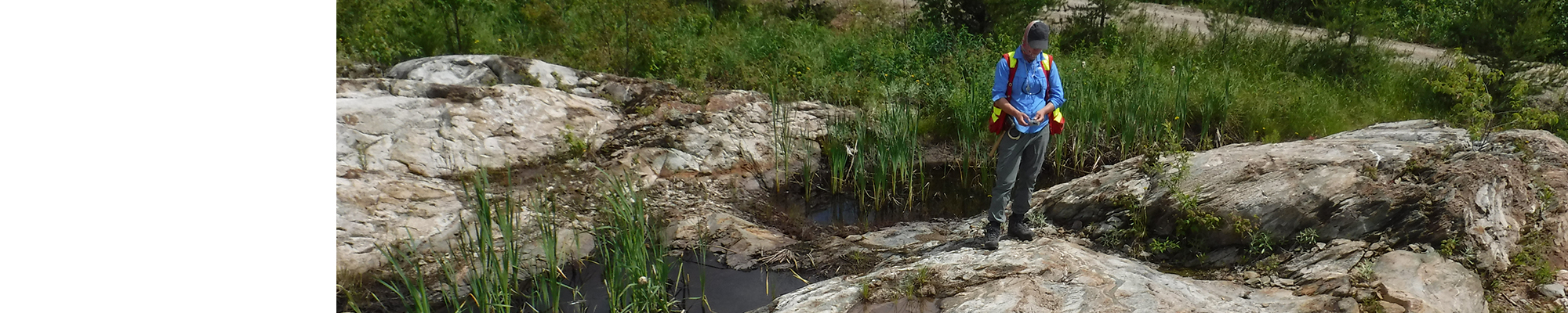
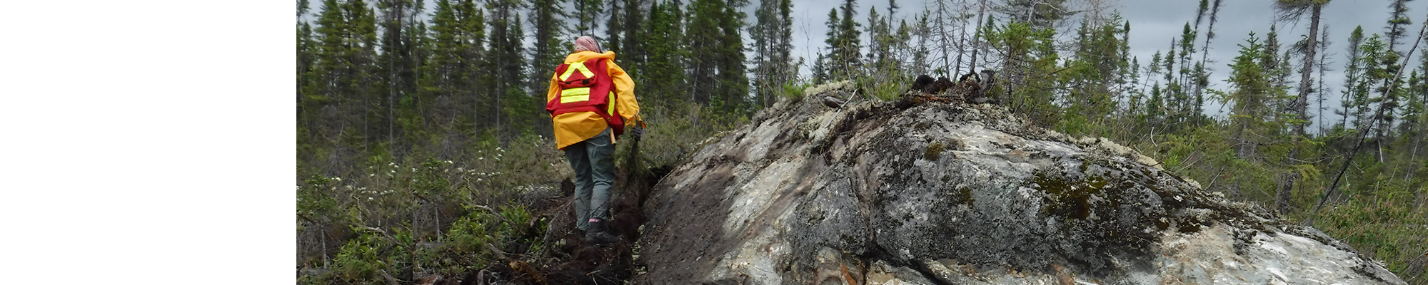
The area was mapped using the established method for surveys in forest areas served by a network of secondary roads. Geological mapping was conducted by a team of one geologist accompanied by a geologist in training between early June and late July 2017. Our work included detailed mapping of selected areas of sheet 32C05 and general compilation of previous geological mapping campaigns, as well as the work of exploration companies in the area. The proposed geological interpretations and stratigraphic correlations are based on existing and ongoing physical volcanology, geochemical data and geochronological (U-Pb on zircons). We also supported our geological interpretation on aeromagnetic maps (new data processing of DP 2008-06) and drilling data compiled in SIGÉOM.
Mapping of the study area produced and updated the information presented in the table below:
| Elements | Number |
|---|---|
| Outcrops described (“geofiches”) | 133 |
| Total lithogeochemical analyses | 66 |
| Lithogeochemical analyses of metals of economic interest | 4 |
| Geochronological analyses | 4 |
| Covered thin sections | 80 |
| Polished thin sections | - |
| Sodium cobaltinitrite stains | 5 |
| Stratigraphic units | 8 |
| Mineralization records | 15 |
Previous Work
The table below provides a list of the work done since 1929 in the study area. Also included are the references cited in the report.
| Author(s) | Type of work | Contribution |
|---|---|---|
| Bell, 1931 | Description of gold showings | Venus Gold Mine, Barraute Township |
| Beullac, 1983 | Geological mapping | Geology of the Barraute-Fiedmont Region |
| Description of mineralized showings | Metallogeny of high-tech metals in Abitibi-Témiscamingue | |
| Brown, 1957, 1958 | Geological mapping | Preliminary report on the geology of the NE quarter of Fiedmont Township |
| Daigneault, 1996 |
Description of Abitibi fault and shear zones | Abitibi Subprovince deformation corridors |
| Dawson, 1966 | Geological mapping and description of mineralized showings (GSC) | Studies of the various intrusive phases of the Preissac-La Corne Batholith |
| Doig, 1963 | Geological mapping | Geology of the SE quarter of Landrienne Township and the SW quarter of Barraute Township |
| Imreh, 1979 | Geological Association of Canada, Quebec City Congress, 1979; field guidebook | Lithostratigraphy and ultramafic rocks in the Val d'Or-Amos area |
| Imreh, 1984 | Geological mapping | Synthesis of the La Motte-Vassan trough and its southern foreland |
| Imreh, 1991 | Geological mapping | Preliminary 1:15,840 geological maps of southern Abitibi-Est - NW quarter of sheet 32C05 |
| James and Mawdsley, 1929 | Geological mapping (GSC) | Geology of the Fiedmont region, Abitibi County, Quebec |
| Geological mapping | Geology of the NW quarter of Fiedmont Township | |
| Keating, 1979 | Geophysical surveys | Compilation of Input-type electromagnetic anomalies |
| Lacoste, 1984 | Geological mapping | Geology of the Fiedmont Lake area |
| Latulippe and Ingham, 1955 | Description of mineralized showings | Lithium deposits in the La Corne region |
| Leuner, 1959 | Geological mapping | Preliminary geological report on the western half of La Motte Township |
| MER, 1984 | Geological compilation | Geoscientific compilation map of sheet 32C05 |
| MERN, 2009 | Geophysical surveys | MEGATEM-colour geophysical maps, sheet 32C05 |
| Pilote, 2015 | Geological mapping | Geology of the La Corne region |
| Sharpe, 1961 | Geological mapping | Preliminary geological report on the southern half of Figuery Township and the SW quarter of Landrienne Township |
| Tremblay, 1946, 1947, 1950a, 1950b | Geological mapping (GSC) | Geology of the La Corne and Fiedmont regions |
| Van Loan, 1959 | Geological mapping | Geological report of the southern half of Fiedmont Township |
Lithostratigraphy
The area west of Barraute (interactive map) is located in the southern part of the Abitibi Subprovince of the Superior Province (Dimroth et al., 1982; Card and Ciesielski, 1986; Calvert and Ludden, 1999; Thurston et al., 2008; Percival et al., 2012). Rocks in this area form an Archean volcano-sedimentary pile of ultramafic, mafic and felsic volcanic and volcaniclastic rocks (2727 ±2-2708 ±2 Ma; Pilote et al., 2009) separated by narrow strips of sedimentary rocks (<2691, 2688 and 2687 Ma; Feng and Kerrich, 1991; Mortensen and Card, 1993; Davis, 2002).
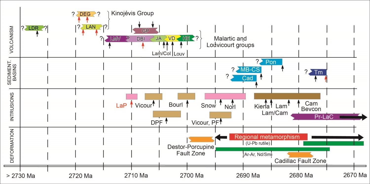
A compilation of the major zircon U-Pb geochronological datings is presented on the adjacent figure. Abbreviations are as follows: Volcanism: LDR = Landerienne Formation, DEG = Deguisier Formation, LAN = Lanaudière Formation, LMV = La Motte-Vassan Formation, DBI = Lower Dubuisson Formation, JA = Jacola Formation, VD = Val-d'Or Formation, HE = Héva Formation, GP = Piché Group, Col = Columbière Rhyolite, Lam = Lamaque Dacite, Louv = Louvicourt Dacite. Sedimentary basin: Cad = Cadillac Group, MB = Mont-Brun Formation, CS = Caste Formation, Pon = Pontiac Group, Tm = Timiskaming Group. Intrusions: LaP = La Pause Pluton, Vicour = Vicour sill, DPF = Sigma Mine feldspar porphyritic dyke (porphyritic diorite), Bourl = Bourlamaque Batolith, Snow = Snowshoe Stock, PF = Sigma Mine feldspar porphyritic dyke, Norl = Norlartic Tonalite, Kiena = Kiena Mine granodiorite, Lam = Lamaque Mine central tonalitic intrusion (Main Plug), Cam = Camflo Mine monzonite, Bevcon = Bevcon Pluton, Pr-LaC = Preissac-La Corne Plutonic Suite. Data in red are from McNicoll’s work (cited in Pilote et al., 2009). Timing of regional metamorphism remains unclear. See Pilote et al. (2009) for details.
In the area west of Barraute (geological map), there is from north to south: 1) the Deguisier Formation (nAdg), included in the Kinojévis Group (nAki); 2) the Landrienne Formation (nAla); 3) the Lanaudière Formation (nAln), also included in the Kinojévis Group; and 4) the Caste Formation (nAlc). Numerous pre-tectonic to post-tectonic intrusions with a dioritic-tonalitic to monzonitic and monzogranitic composition cut the volcanic sequence, the main one being the La Corne Batholith (nAlac). The various volcanic units are separated from each other by faults or narrow strips of kilometre-thick clastic sedimentary rocks, themselves bordered by faults. All these lithologies are cut by Proterozoic NE-SW-oriented diabase dykes.
The main regional faults are, from north to south: the Abcourt, Aiguebelle, Matissard and Manneville Nord faults (geological map). These structures, oriented E-W to NW-SE, play an important role in: (1) controlling the continuity of stratigraphic units; 2) marking the edges of younger sedimentary units; 3) distributing successive increments of regional deformation; and (4) their particular mineral potential, demonstrated, for example, by an increased density of diabase dykes and intrusions near them.
VOLCANO-SEDIMENTARY UNITS
Volcanic Rocks
The geological and stratigraphic framework of terrains north of the Manneville Nord Fault and faults associated with the Destor-Porcupine system are locally well defined through the work of Sharpe (1961) and Imreh (1979, 1984, 1991), and more recently Mueller et al. (1996), Goutier (1997), Daigneault et al. (2002, 2004) and Pilote et al. (2009) (geological map). The Destor-Porcupine system and its many branches play a fundamental role in the distribution of volcanic units. Below, the stratigraphic units are described from north to south.
The oldest rocks in the area are located in the Landrienne Formation. This formation is not assigned to any group at this time. It is bordered by longitudinal faults, the Abcourt (north side) and Aiguebelle (south side) faults, and interbedded between the Deguisier Formation to the north and the Lanaudière Formation to the south.
The Landrienne Formation consists of the following units in the area west of Barraute:
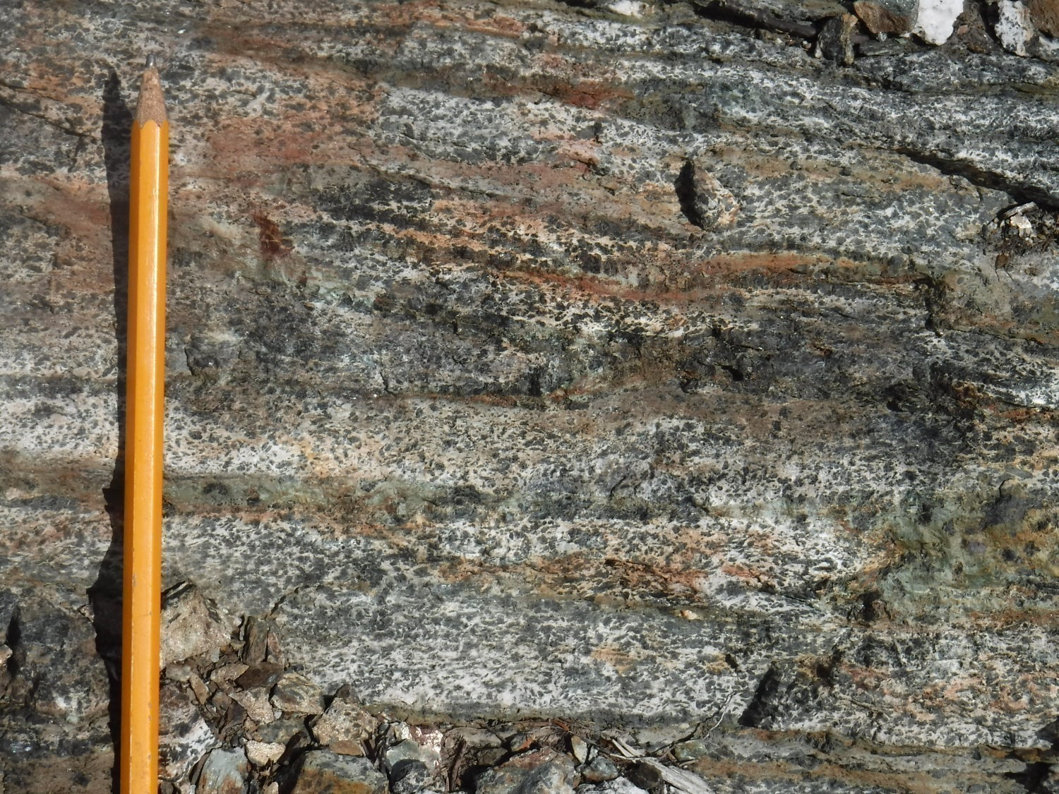
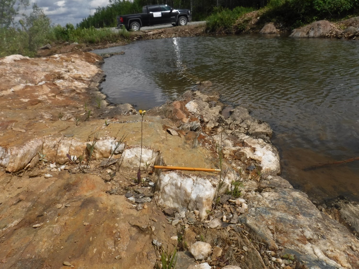
The Landrienne Formation consists of massive to pillow basalt, gabbro sill, pyrite-graphite volcaniclastics and finally intermediate to felsic volcanics (outcrop 17-PP-30). These units are repeated several times by a series of overfolds, including at least two synclinals (Figuery and Barraute) and one anticlinal (geological map). A rhyolitic unit dated by Labbé (1999) yielded a zircon U-Pb age of 2727 ±2 Ma (“Héva Nord” site). This age is significantly different from that of adjacent volcanic formations, both north and south, and can only be explained by a structural scenario involving a collage of separate lithotectonic panels.
In the Destor region (sheet 32D07-200-0201), the Kinojévis Group (Naki) was subdivided by Goutier (1997) into two formations: the Deguisier (nAdg) and Lanaudière (nAln) formations. These formations continue eastward in the La Corne area.
The Deguisier Formation (Hocq, 1977; Sanschagrin and Leduc, 1979; Goutier, 1997) forms an E-W-oriented strip that ranges from one to nearly 5 km in stratigraphic thickness (Preissac area). This formation has moderate to abrupt dip northward, with polarity commonly facing south.
The Deguisier Formation consists of the following units in the area west of Barraute:
nAdg3: Volcanics and felsic volcaniclastics
nAdg4: Andesite and intermediate to mafic volcaniclastics
nAdg5: Gabbroic sill, magnetite basalt and mafic volcaniclastics
The Deguisier Formation consists of Fe-high and Mg-high tholeiitic basalts, massive and pillowed, thin chert horizons between flows, tholeiitic lobed rhyolite and intermediate to felsic volcaniclastics (outcrop 17-PP-08), some of which have been dated 2719.4 ±1 and 2718.1 ±1.3 Ma (McNicoll, cited in Pilote et al., 2009). Its most distinctive feature is the abundance of gabbroic sills. These latter sills are more prevalent in the upper (southern) portion of the formation. To the west of the mapped area, volcanic facies and petography of lava were described in detail by Sanschagrin and Leduc (1979), Leduc (1980) and Sanschagrin (1981). Many tonalitic dykes and sills cut this formation.
The Lanaudière Formation is delimited by the Manneville Nord and Aiguebelle faults, which have shallow dip to the north (Mueller et al., 1996; Daigneault et al., 2002). They may represent subsidiary faults of the more westerly Destor-Porcupine system (Goutier, 1997; Legault et al., 2005). Goutier (1997) and Pilote et al. (2009) proposed that the Deguisier and Lanaudière formations were initially joint and subsequently separated by faults.
This formation consists of the following units in the area west of Barraute:
nAln1: Rhyolite, dacite and felsic volcaniclastics
nAln2: Basalt and mafic volcaniclastics
nAln3: Komatiite ultramafic sill, basalt and mafic volcaniclastics
nAln5: Magnesian basalt, basalt, gabbro and mafic volcaniclastics
nAln13: Sandstone, turbiditc and graphitic mudrock, black claystone
The Lanaudière Formation consists of abundant ultramafic lava, mafic to felsic volcanics (Sanschagrin and Leduc, 1979; Goutier, 1997; Pilote et al., 2009), as well as numerous intrusions of tonalitic to monzonitic composition, particularly on the first kilometre in contact with the La Corne Batholith. These units are oriented E-W and have moderate to shallow dip northward. They have polarity regularly oriented towards the south. Two of the rhyolitic complexes of this formation, which define tholeiitic suites, yielded zircon U-Pb ages of 2718.7 ±0.7 and 2716.2 ±0.8 Ma (McNicoll, cited in Pilote et al., 2009). These ages, as well as the close spatial association observed between ultramafic lava and rhyolitic complexes of this formation, point to several significant comparisons with the Kidd-Munro Assemblage (Bleeker et al., 1999; Berger, 2002; Ayer et al., 2002).
Sedimentary Rocks
The Fiedmont Formation (nAfd) is located in the central-east portion of the map, where it outcrops as a narrow strip of sedimentary rocks approximately 200 to 800 m wide and oriented E-W (geological map). This strip of sedimentary rocks is bordered on its northern contact by the Aiguebelle Fault. Sedimentary units tend to circle the La Corne Batholith and continue southeast in a N-S orientation.
This formation consists of the following units in the area west of Barraute:
nAfd2: Grauwacke and biotite schist
nAfd3: Conglomerate and conglomeratic sandstone
It contains joint-pebble conglomeratic sandstones, granitoid-fragment polygenetic conglomerates, volcanics and numerous cross-bedded sequences representative of fluviatile deposition environments. A preliminary zircon U-Pb dating gave an age of 2717 Ma (J. David, in progress). At present, considering the age and special nature of conglomerates, these sedimentary units are interpreted as characteristic of a synvolcanic event. Subsequent fieldwork will deepen these interpretations.
The Kewagama Group (nAkw) is a unit introduced by Goutier (1997) that brings together different strips of turbidite-type sedimentary rocks with several similarities. This group includes the Dufresnoy River, Mont-Brun and Caste formations. Only the latter occurs in the area west of Barraute.
nAlc: Sandstone, turbiditic and graphitc mudrock, black claystone, polygenetic conglomerate, biotite schist
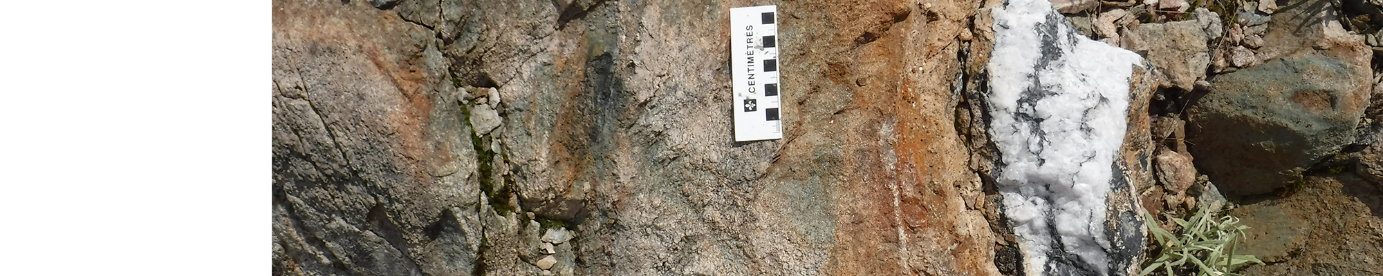
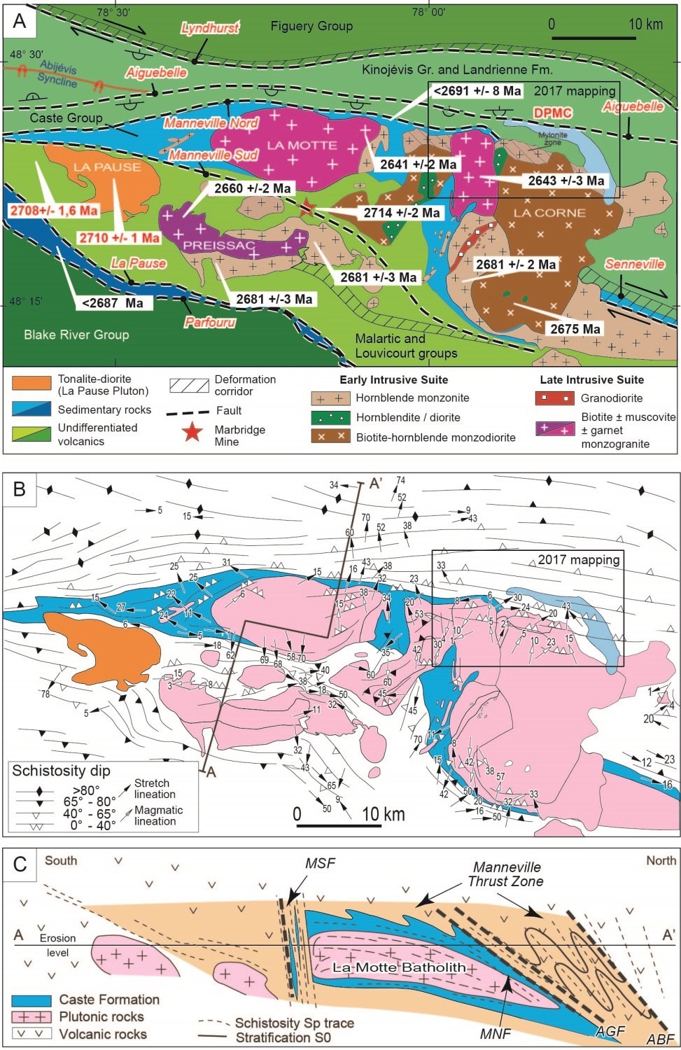
The Caste Formation forms several distinct sedimentary rock strips of varying thickness and extent, in fault contact with volcanics of the Kinojévis Group (geological map). The largest strip surrounds the La Motte and La Corne batholiths (adjacent geological map, Figures A and B). The geology was modified from Dawson (1966), Imreh (1984), Boily et al. (1990), Boily (1992), Daigneault (1996) and Pilote et al. (2009). Near the La Corne Batholith, contact metamorphism produces biotite schists. The Caste Formation sedimentary rocks are bordered on the north side by the Manneville Nord Fault and truncated to the south by the La Corne Batholith.
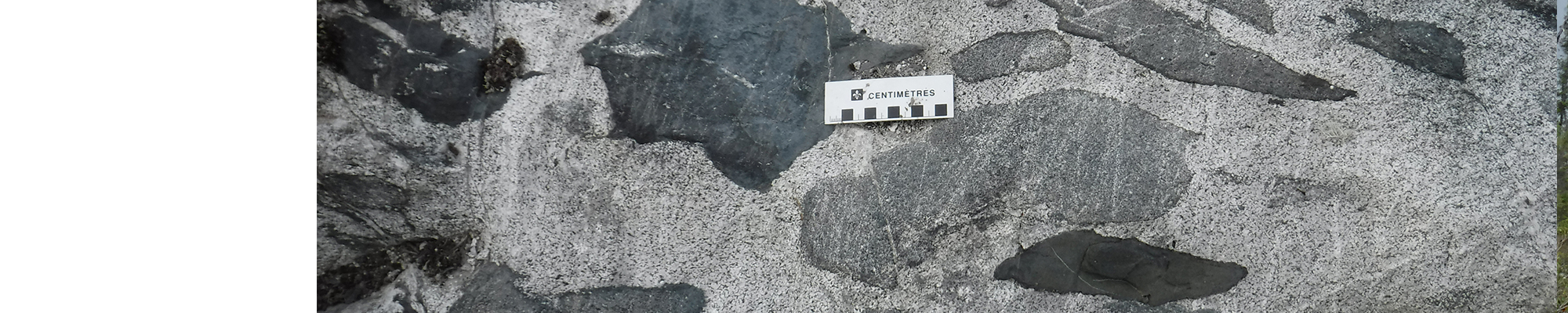
The Caste Formation (nAlc, U-Pb age <2691 ±8 Ma; Feng and Kerrich, 1991) essentially consists of alternating green to beige wacke and light green pelite, variably deformed, originally a turbiditic sequence rich in wacke and mudrock. Primary structures, including normal sorting and cross-bedding, can be identified in these rocks. Mineralogical banding is subparallel to the main schistosity and shows evidence of intense flattening and strong transposition.
INTRUSIVE UNITS
Preissac-La Corne Plutonic Suite (nAplc)
This large plutonic package consists of the Preissac, La Motte and La Corne batholiths, and large sequences of granitic pegmatites (geological map, Figure A). Various aspects of the geology of these plutons were examined by Siroonian et al. (1959), Sharpe (1961), Dawson (1966), Brett et al. (1976), Imreh (1984), Beullac and Imreh (1987), Boily et al. (1990), Boily (1992), Mulja et al. (1995a and 1995b), Daigneault (1996) and Pilote et al. (2009).
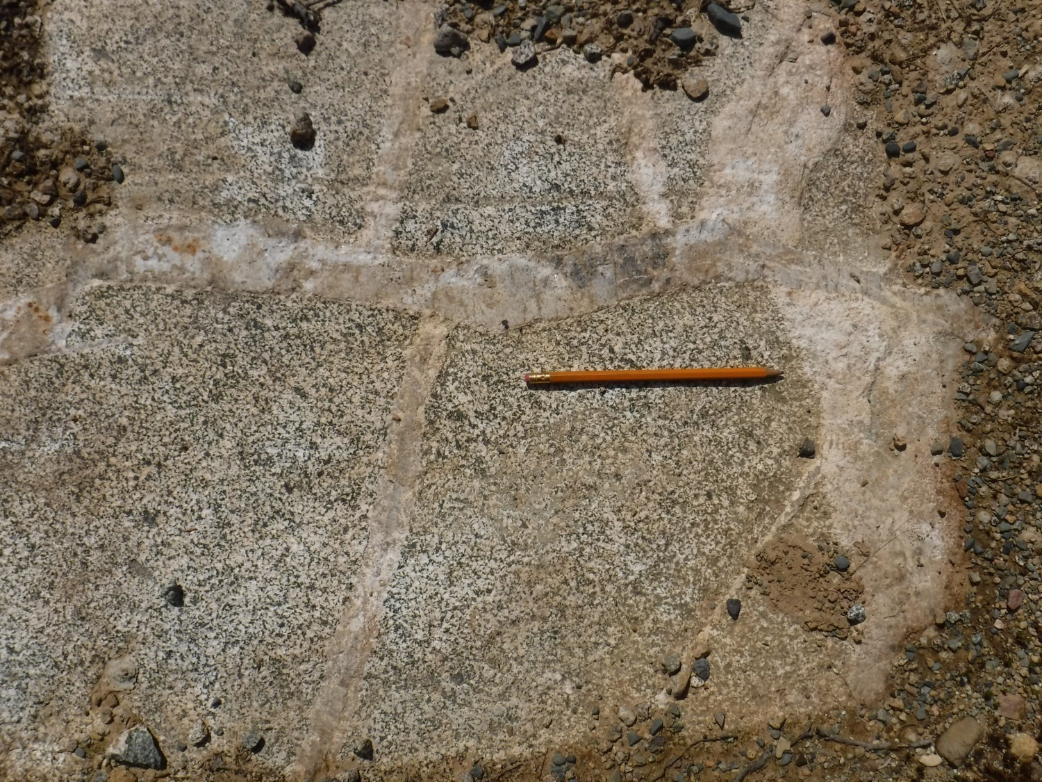
The Preissac-La Corne Plutonic Suite forms a syn-kinematic to post-kinematic complex emplaced in the Archean (2681-2643 Ma), mainly hosted in metasedimentary rocks of the Caste Formation. This suite consists of two magmatic suites: 1) an early metaluminous dioritic to granodioritic suite (2681-2660 Ma); and 2) a late peraluminous monzogranitic suite (2643 Ma). Biotite-muscovite monzogranites predominate in the La Motte Batholith and in part of the La Corne Batholith, while the Preissac Batholith is mainly composed of muscovite-garnet monzogranites. A granitic pegmatite aureole mineralized in Li, Be and Ta is associated with the monzogranitic suite and is also found in host lithologies. Several quartz-feldspar-musovite hydrothermal veins mineralized in Mo cut the musovite-garnet monzogranitic facies of the Preissac Batholith.
The area waest of Barraute includes, in its southern half, the northern portion of the La Corne Batholith (nAlac) (Dawson 1966), Danis (1985), Bourne and Danis (1987), Boily et al. (1989, 1990), Rive et al. (1990), Boily (1992, 1995), Mulja et al. (1995a, 1995b). This batholith consists of the following intrusive phases:
nAlac1: Quartz monzonite and granodiorite, fine-grained felsic intrusion and pegmatite
nAlac2: Monzogranite, monzonite and fine-grained felsic intrusion
nAlac3: Hornblende monzonite
nAlac4: Hornblendite and amphibolite
nAlac5: Monzodiorite and quartzt monzodiorite
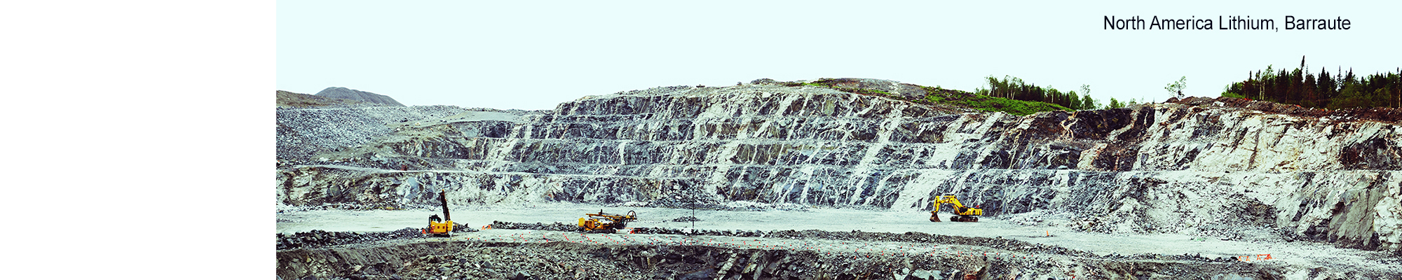
Early facies (nAlac4, nAlac3, nAlac1 and nAlac5), which are the most abundant, consist of diorite, hornblende monzonite and monzodiorite. The northern part of this batholith, facies nAlac1, is particularly rich in amphibolitized enclaves, and contains most of spodumene pegmatites in this area, including the North American Lithium Mine. This facies cuts the Fiedmont Formation conglomerates in their southeasterly extension (geological map, Figure A). The late facies (nAlac2), dated 2643 Ma (Feng and Kerrich, 1991) and located in the central-north portion of the La Corne Batholith, consists of biotite monzogranite and muscovite-biotite monzogranite.
Proterozoic Diabase Dykes
The area west of Barraute is cut by three dyke swarms, two of which are Paleoproterozoic, the Senneterre and Biscotasing dykes, and the third Mesoproterozoic Abitibi Dykes.
pPsen: Diabase dyke
pPbis: Diabase dyke
mPabi: Olivine diabase dyke
Biscotasing and Senneterre dykes are subophitic gabbro dykes oriented ENE-WSW to NE-SW. Diabase has a characteristic brown patina and green fresh surface. It is composed of plagioclase, pyroxene, olivine, chlorite and epidote. Hematite is very abundant locally. As for the Abitibi Dykes, they group olivine diabases oriented NE-SW to NNE-SSW, not metamorphosed and weakly altered. These three swarms cut the La Corne Batholith and all volcanics in the area (geological map). The position of these dykes was plotted on the geological map in large part thanks to aeromagnetic surveys (aeromagnetic map). The orientation of their palaeomagnetism as well as their U-Pb age are two of the main characteristics distinguishing these different swarms (Fahrig et al., 1986; Krogh et al., 1987; Ernst and Buchan, 1993).
Structural Geology
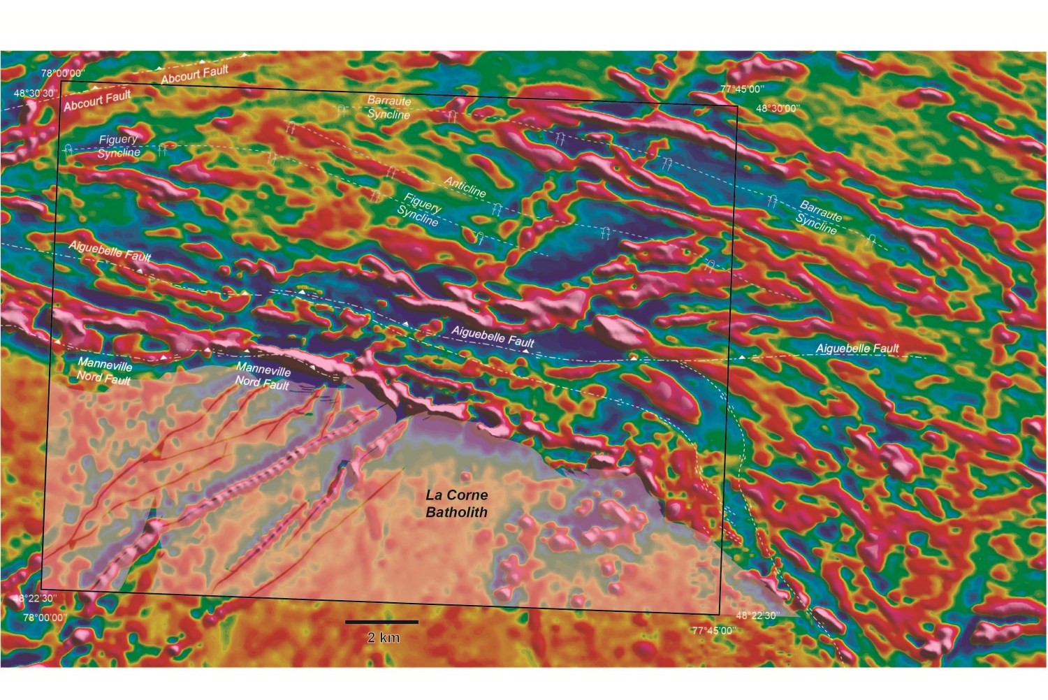
The following nomenclature has been established for the different structural elements observed in the La Corne region. The oldest regional schistosity has been designated S1. It is almost subparallel to stratification S0, except near hinges of large synclinal and anticlinal folds P1, which are clearly visible in the central part of the Landrienne Formation (geological map and aeromagnetic map). These folds' axial plane traces were defined by combining our field work with regional aeromagnetic surveys and adjacent geological maps. Thus, the Barraute Syncline trace corresponds to the westward extension of the same fold highlighted by the Beullac (1984) mapping further east. Planar elements S0 and S1 show an E-W to ESE-WNW orientation and a moderate 30 to 50° dip northward. The S1 fabric is more pronounced near large regional faults. It commonly becomes mylonitic on the edge of the La Corne Batholith. Stretch lineation associated with this schistosity is commonly abruptly plunging towards the north and NNE, almost subparallel to the S1 fabric dip (geological map, Figure B).
Manneville Thrust Zone


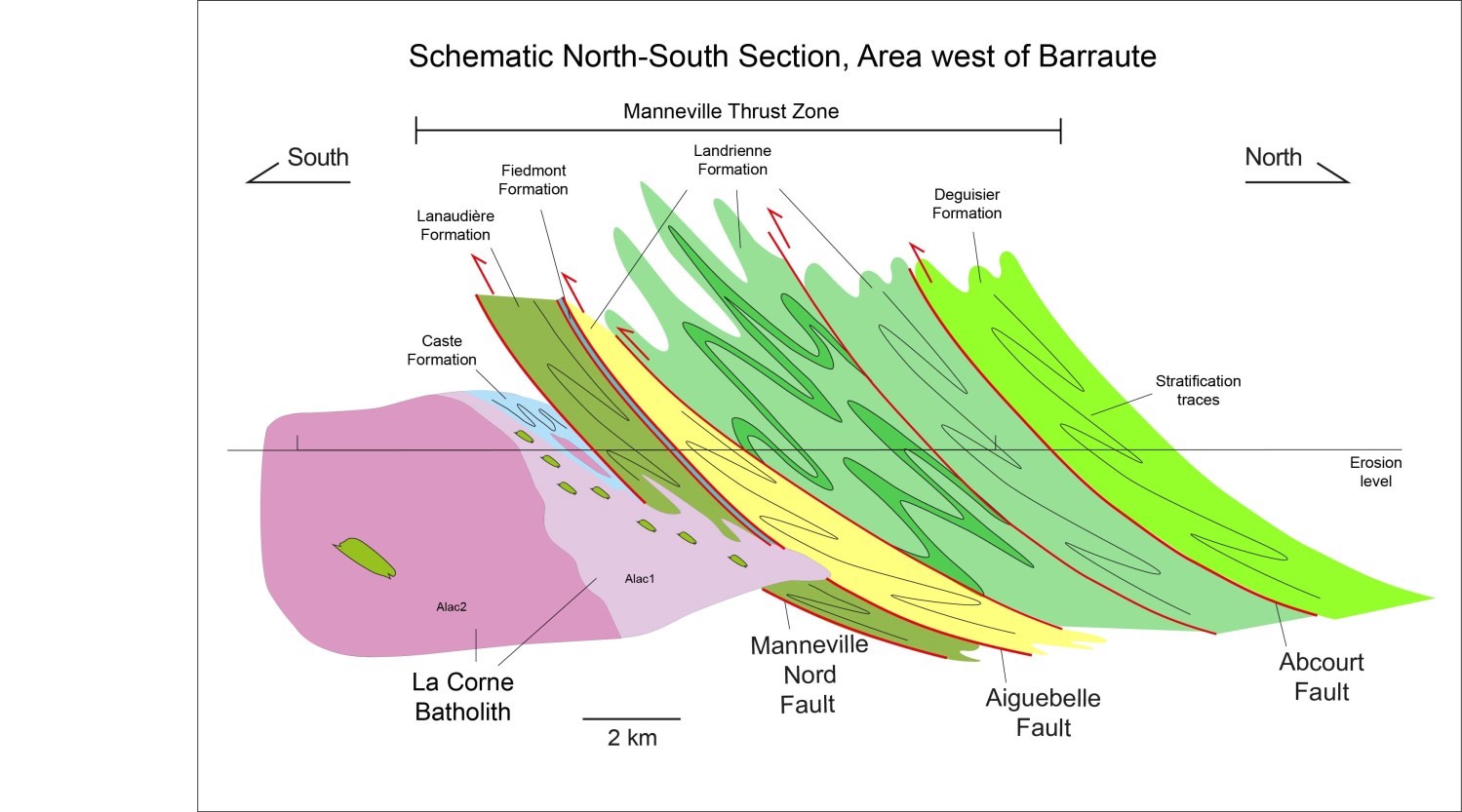
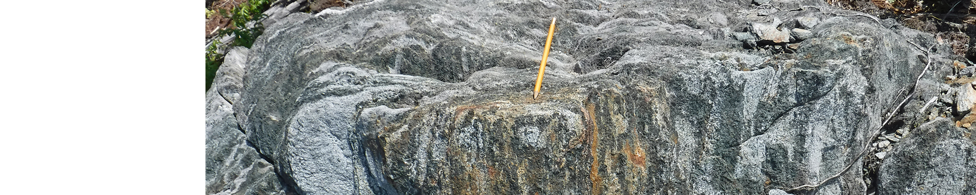
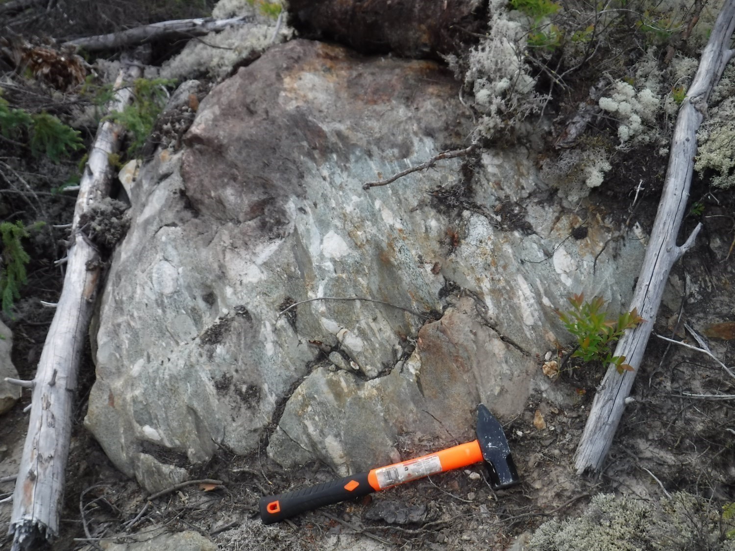
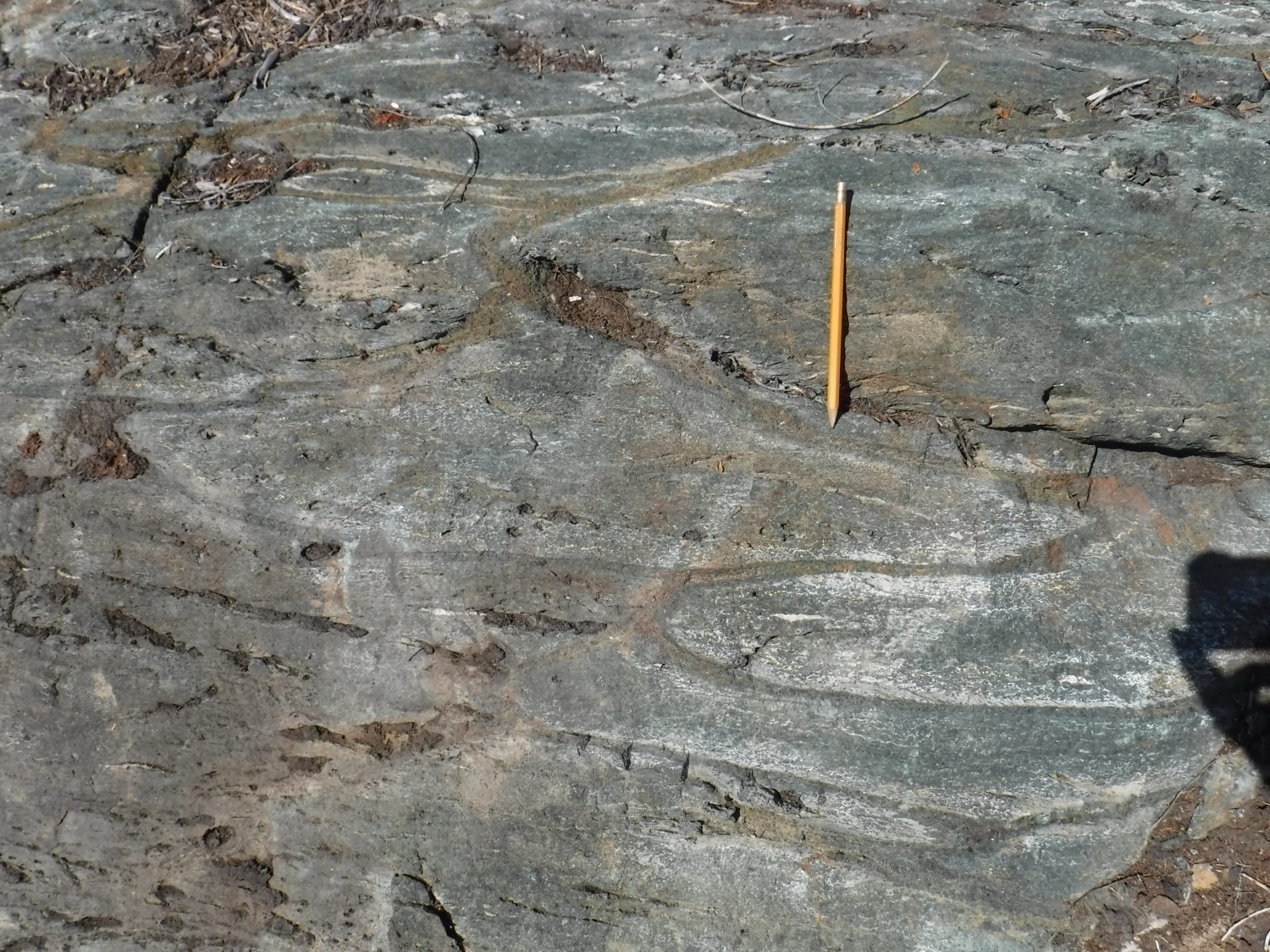
One of the most important structural elements in this region is the Manneville Trust Zone (MSZ; Daigneault et al., 2002; geological map, Figure C). This thrust zone, of regional scope, is mainly defined in the field by a S0/S1 surface with shallow dip (30° to 50°) northward. Stratification is overturned with polarities facing south, which is confirmed by pillow lava arrangement (outcrop 17-PP-77). This thrust affects the entire Kinojévis Group (outcrop 17-PP-75), the Landrienne Formation, and the Caste Formation sedimentary rocks, resulting in an apparent horizontal thickness of 2 to 6 km (geological map) for this structure. Similar geometric relationships are observed along this thrust zone over several tens of kilometres in an E-W direction (Daigneault et al., 2002). These observations are important elements in favour of an early origin of this thrust zone (Daigneault et al., 2002), where the north compartment overthrustss the south compartment (geological map, Figure C). In a westerly direction towards the Preissac area, these angular relationships are vertically displaced and obliterated in the Porcupine-Destor Deformation Zone, which then overlaps with this thrust.
Reverse Faults with Moderate to Steep Dip
Several faults oriented E-W to ESE-WNW and with moderate to steep dip cut the Manneville Sud Zone (MSZ), the most important being the Matissard, Manneville Nord (MNF), Aiguebelle (AGF) and Abcourt (ABF) faults (geological map, Figures B and C). In many cases, large lithotectonic assemblages (geological map, Figures A and B) are bordered by these faults. They are likely to represent complex imbricate zones, both in the number of faults and the lithological varieties and ages of contiguous lithotectonic ensembles.
These faults isolate separate lithological panels composed of volcanics of various origins, some folded by P1 folds with axial planes overfold southward. For example, note the imbrication of the Landrienne Formation, including a rhyolite dated 2727 ±2 Ma (Labbé, 1999), inserted between rocks of the Lanaudière (including rhyolitic units dated 2718.7 ±0.7 and 2716.2 ±0.8 Ma (Pilote et al., 2009)) and Deguisier formations. These faults are interpreted as being part of a tectonic front associated with south-verging E-W thrusts (Mueller et al., 1996, 2008; Daigneault et al., 2002). These faults have a progressively steeper dip westward; they break down the internal architecture of the Kinojévis Group and the Landrienne Formation, providing a specific structural style for each unit, depending on its initial orientation. These faults may have allowed creation of sedimentary basins (Fiedmont Formation) and facilitated intrusion of many syntectonic dykes.
The Aiguebelle Fault, inclined 75° northward, consists of a metre-thick graphitic sctructure cut by porphyritic tonalitic dykes. It was mapped using stratigraphic discontinuities and drilling data. Schistosity S1 is slightly folded, straightened and obliterated on the immediate edge of this fault, as well as near other similar late fractures.
In the field, the Manneville Nord, Matissard, Aiguebelle and Abcourt faults or certain reactivated segments may represent the easterly extension of the Destor-Porcupine gold-bearing and structural event, superimposed on the Manneville thrust. Although the general expression “Destor-Porcupine-Manneville Deformation Corridor (DPMC)” is used by some authors to describe all of these phenomena, it should be noted that the expression “DPMC” comprises two types of structures of distinct age that have succeeded to one another over time but are spatially overlaid, namely: 1) the Manneville Thrust Zone; and 2) late E-W faults that cut and cross this zone. The E-W DPMC extends nearly 350 km from Timmins, Ontario to south of Senneterre eastbound.
NE-SW Sinistral and NW-SE Dextral Faults
Smaller, later, NW and NE-oriented faults cut the major E-W faults described above. These faults have been identified or interpreted by mapping, drilling, or numerous aeromagnetic and electromagnetic surveys at different scales.
IMPORTANT STRATIGRAPHIC AND STRUCTURAL OBSERVATIONS:
- the Deguisier and Lanaudière formations are equivalent in age to the Lower Kidd-Munro Assemblage observed on the Ontario side;
- the importance of regional folds is locally significant in the case of the Landrienne Formation. This is a consideration for the optimal orientation of geophysical surveys facing stratigraphic surfaces;
- the role of E-W and ESE-WNW faults and deformation corridors and the presence of intrusive suites along certain segments;
- the regional importance of the Manneville Thrust Zone, development of a synvolcanic sedimentary basin, recovery and obliteration of more or less severe faults associated with the Porcupine-Destor Deformation Corridor, which is representative of a later major gold event, with specific alkaline intrusive suites;
- the Landrienne Formation is a unique lithotectonic slice with its own geometry and structural history incorporated into the Manneville Thrust Zone.
Metamorphism
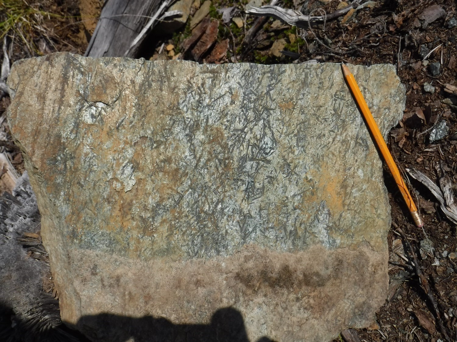
The degree of regional metamorphism, as observed in the La Corne area, moves from the amphibolite facies in the south half of the geological map (outcrops 17-PP-80 and 17-PP-81) to that of the greenschist facies in its northern half. The typical mineralogical assemblage of massive and pillowed mafic volcanics consists of albite-actinolite or light green hornblend-chlorite-epidote-quartz-carbonate. Ultramafic units are tremolitized and serpentinized (i.e., converted to talc and chlorite schist). The mineral assemblage of serpentinized ultramaphics consists, more precisely, of serpentine-magnetite-chlorite ± talc ± carbonate ± quartz (Jones, 1964; Imreh, 1984, 1991; Daigneault et al., 2002, 2004).
Economic Geology
The area west of Barraute has prospective zones for four (4) mineralization types:
- exhalative volcanogenic massive sulphide (VMS) mineralizations associated with felsic volcanism of the Landrienne Formation;
- orogenic gold mineralizations associated with the Fiedmont Formation synvolcanic sedimentary Basin;
- granitic pegmatite sequences and lithium-beryl-molybdenum mineralizations associated with the La Corne Batholith;
- orogenic gold mineralizations associated with quartz-tourmaline veins in NW-oriented shear zones.
(E) : selected sample; (R) : channel; (F) : drillhole
The table of lithogeochemical analyses of metals of economic interest provides the location, description and results of four (4) samples selected for assessing the economic potential of the region.
Prospective Zone for Exhalative Volcanogenic Massive Sulphide Mineralization
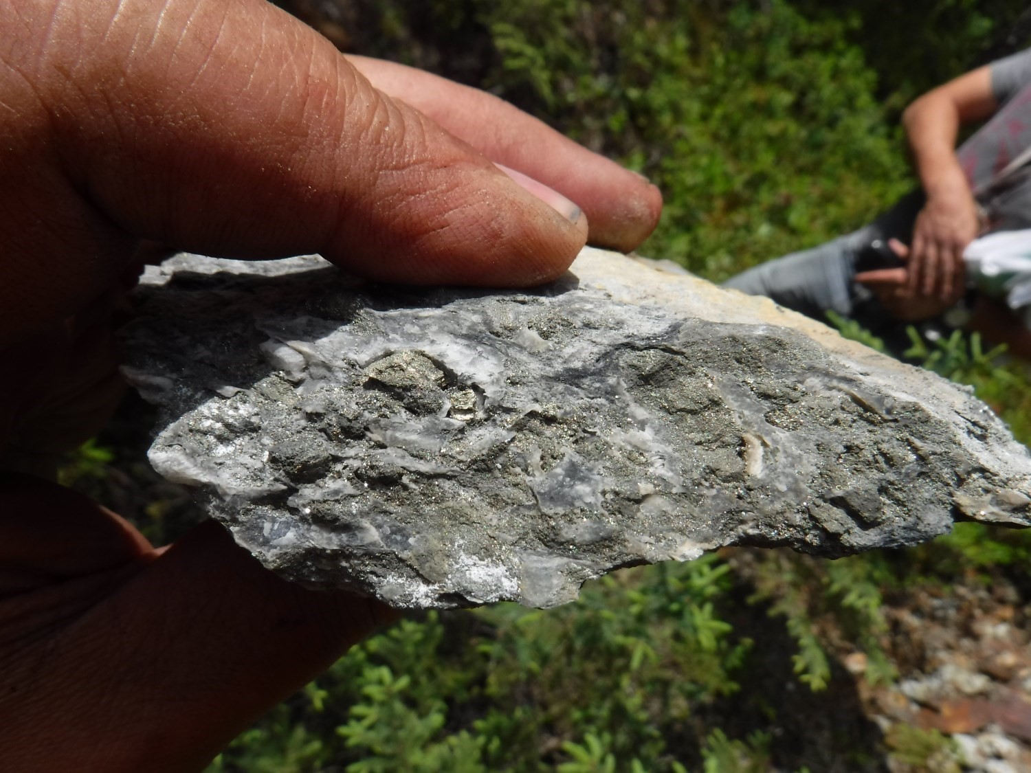
In the central part of the study area, felsic to intermediate volcanic rocks of tholeiitic affinity of the Landrienne Formation, corresponding to units nAla5, nAla7, nAla10, nAla11, nAla12, nAla13 and nAla15, are a prospective zone for volcanogenic massive sulphide mineralization. This prospective zone, part of the MSZ, includes Project 70 - Landome, Marcoland and Landrienne Sud mineralized zones. This mineralization occurs as massive to semi-massive sulphide clusters, dykes and more locally disseminations. Stratification and sschistosity are oriented E-W with a 35 to 45° dip northward. Intensity of deformation varies from moderate to intense. Beds of discontinuous sedimentary rocks containing pyrite, magnetite and graphite are common (units nAla7 and nAla13). Felsic volcanics of unit nAla5 and host of the Project 70 - Landome site yielded a zircon U-Pb age of 2727 ±2 Ma (Labbé, 1999). A 1975 Placer Dome reserve calculation on the Project 70 - Landome site indicated 251,000 tonnes at 2.48% Cu and 2.02% Zn (historical reserves not meeting the 43-101 norm).
Recognition of a New Synvolcanic Sedimentary Basin with Gold Potential Northeast of the La Corne Batholith
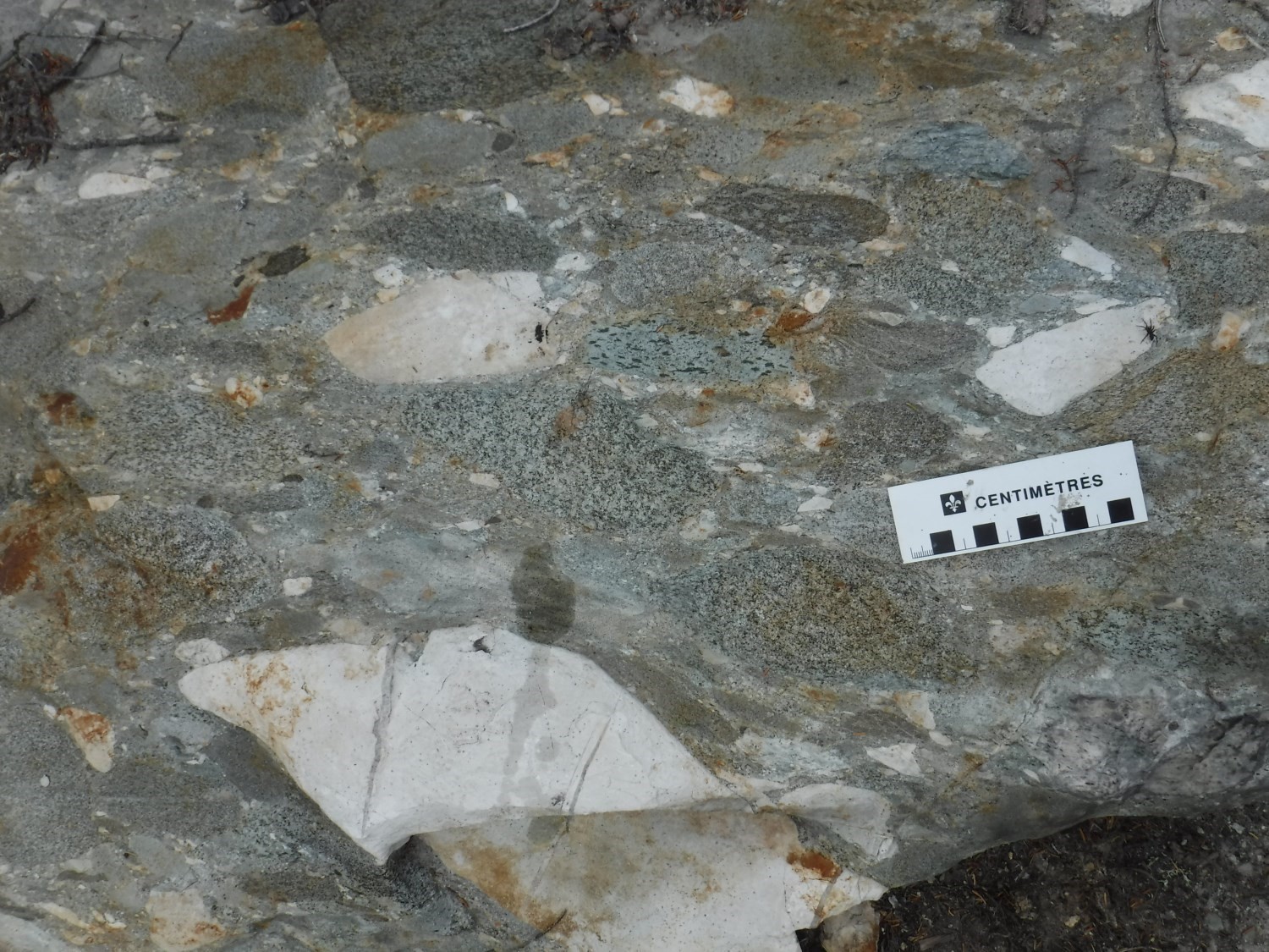
This prospective zone corresponds to a sandstone, conglomeratic sandstone and polygenetic conglomerate unit assigned to the Fiedmont Formation (nAfd). Stratification and regional schistosity are oriented E-W to NW-SE, crossing the study area from west to east. Polarities are oriented towards the SW. Conglomerates contain highly characteristic pebbles of mafic and felsic volcanic rocks and granitoids, as well as disseminated pyrite and magnetite. These lithologies show typical structures of fluviatile environments, such as cross-bedding, and are similar to Timiskaming-type sedimentary units. However, the preliminary age obtained by zircon U-Pb dating (2717 Ma; J. David, ongoing work) suggests that the formation of this basin would be more contemporary to volcanism of the Kinojévis Group. Ongoing and future work in this area and surrounding areas will attempt to clarify these points. The Fiedmont Formation is truncated to the SE by the La Corne Batholith. This sedimentary basin offers new opportunities for identification of orogenic gold mineralization due to the presence of: 1) polygenetic conglomerates; (2) significant faults that follow contacts in that basin; and 3) numerous felsic dykes cutting sedimentary units that compose this basin.
Mineralized Granitic Pegmatite Sequences in Periphery of the La Corne Batholith
This prospective zone contains various intrusive facies located on the northern periphery of the La Corne Batholith (nAlac), as well as mafic and ultramafic volcanics immediately adjacent to the Lanaudière Formation. Mineralized zones are granitic pegmatites that may contain spodumene (lithium), beryl or molybdenum. The North American Lithium Mine (former Quebec Lithium Mine), in production in 2017, is located in this prospective zone. It also includes the New Athona-2, Keyboycon, Martin-McNeely, Canadian Lithium, Augustus Exploration, Vallée Lithium, La motte-Est, Buffalo Canadian-Abitibi, Massberyl and Valor Lithium mineralized sites. The majority of these showings were discovered by surface surveying.
Extension of the Manneville Thrust Zone and Manneville Nord, Aiguebelle and Abcourt faults
The Manneville Thrust Zone and the Manneville Nord, Aiguebelle and Abcourt faults define the structural style of this area and offer potential for orogenic gold mineralization. These faults are found particularly on the edge or inside the Landrienne Formation. This prospective zone contains several orogenic gold-bearing quartz-tourmaline-pyrite veins, oriented NW-SE, with dip towards the NE (shear veins) and SW (extension veins; outcrop 17-PP-44). This zone includes the Randall-Fisher, Orbite-1 and R-90-5 mineralized zones.
| Authors | Pierre Pilote, Eng., pierre.pilote@mern.gouv.qc.ca Réal Daigneault, P.Geo., Ph. D. James Moorhead, P.Geo., M. Sc. |
| Mapping | Christelle Lambert, GIT |
| Geochemistry | Fabien Solgadi, P.Geo., Ph. D. |
| Geophysics | Rachid Intissar, P.Geo., M. Sc. |
| Logistics | Clotilde Duvergier, GIT, B. Sc. |
| Geomatics |
Julie Sauvageau Karine Allard |
| Collaboration and discussion |
Pierre Lacoste, P.Geo., M. Sc. Marie-Andrée Vézina, P.Geo. |
| In charge of deposit records | Pierre Lacoste, P.Geo., M. Sc. |
| Editing | Simon Auclair, P.Geo., M. Sc. |
| Critical review | François Leclerc, P.Geo., Ph. D. |
| English version | Céline Dupuis, P.Geo., Ph. D. |
| Organism | General direction of Géologie Québec, Ministère de l'Énergie et des Ressources naturelles, Government of Québec |
References
Publications available through Sigeom Examine
BELL, L. V., 1931. VENUS GOLD MINES, BARRAUTE TOWNSHIP, ABITIBI COUNTY, PART B. MRN; RASM 1930-B3(A), 15 pages.
BEULLAC, R., 1983. REGION DE BARRAUTE-FIEDMONT. MRN; DP-84-02, 1 map.
BEULLAC, R., IMREH, L., 1987. GEOLOGIE DU SECTEUR DE PREISSAC-LA PAUSE-CLERICY (ABITIBI). MRN; ET 86-03, 44 pages, 1 map.
BOILY, M., 1992. EXPLORATION DES METAUX DE HAUTE TECHNOLOGIE (Li, Be ET Ta) DANS LES SYSTEMES GRANITIQUES PERALUMINEUX DE LA REGION DE PREISSAC - LA CORNE (ABITIBI). MRN; ET 91-09, 32 pages, 1 map.
BOILY, M., 1995. PETROGENESE DU BATHOLITE DE PREISSAC-LACORNE : IMPLICATIONS POUR LA METALLOGENIE DES GISEMENTS DE METAUX RARES. MRN; ET 93-05, 79 pages.
BOILY, M., PILOTE, P., RAILLON, H., 1989. LA METALLOGENIE DES METAUX DE HAUTE TECHNOLOGIE EN ABITIBI-TEMISCAMINGUE. MRN; MB 89-29, 118 pages, 1 map.
BROWN, W. G., 1957. THE NORTHEAST PART OF FIEDMONT TOWNSHIP, ABITIBI-EAST COUNTY. MRN; DP 011, 50 pages, 1 map.
BROWN, W. G., 1958. PRELIMINARY REPORT ON THE NORTHEAST QUARTER OF FIEDMONT TOWNSHIP, ELECTORAL DISTRICT OF ABITIBI-EAST. MRN; RP 364(A), 13 pages, 1 map.
BRETT, P. R., JONES, R. E., LATULIPPE, M., LEUNER, W. R., 1976. CANTON DE LA MOTTE. MRN; RG 160, 164 pages, 1 map.
DAIGNEAULT, R., 1996. COULOIRS DE DEFORMATION DE LA SOUS-PROVINCE DE L'ABITIBI. MRN; MB 96-33, 140 pages.
DOIG, R., 1963. PRELIMINARY REPORT, GEOLOGY OF THE SOUTHEAST QUARTER OF LANDRIENNE TOWNSHIP AND THE SOUTHWEST QUARTER OF BARRAUTE TOWNSHIP, ABITIBI-EAST COUNTY. MRN; RP 510(A), 16 pages, 2 maps.
GOUTIER, J., 1997. GEOLOGIE DE LA REGION DE DESTOR (SNRC 32D/07). MRN; RG 96-13, 39 pages, 1 map.
HOCQ, M., 1977. DEMIE SUD DU CANTON D'AIGUEBELLE (COMTE D'ABITIBI). MRN; DPV 544, 29 pages, 1 map.
IMREH, L., 1984. SILLON DE LA MOTTE-VASSAN ET SON AVANT-PAYS MERIDIONAL: SYNTHESE VOLCANOLOGIQUE, LITHOSTRATIGRAPHIQUE ET GITOLOGIQUE. MRN; MM 82-04, 85 pages, 3 maps.
IMREH, L., 1991. NOTES ACCOMPAGNANT LES CARTES PRELIMINAIRES AU 1:15 840 DE L'ABITIBI-EST MERIDIONAL - PROJET DE GITOLOGIE PREVISIONNELLE - COUPURE 32C/05 W. MRN; MB 90-39, 18 pages, 2 maps.
JONES, R. E., 1964. NORTHWEST QUARTER OF FIEDMONT TOWNSHIP, ABITIBI-EAST COUNTIES. MRN; RG 108(A), 35 pages, 1 map.
KEATING, P., 1979. COMPILATION D'ANOMALIES ELECTROMAGNETIQUES DE TYPE INPUT. MRN; DP 728, 4 maps
LABBÉ, J.-Y., 1999. ETUDES GEOLOGIQUES DANS LA REGION D'AMOS (RECUEIL DE 4 ARTICLES). MRN; ET 98-04, 89 pages.
LACOSTE, P., 1984. GEOLOGIE DE LA REGION DU LAC FIEDMONT. MRN; DP-84-15, 1 map.
LATULIPPE, M., INGHAM, W. N., 1955. LITHIUM DEPOSITS OF THE LACORNE AREA, QUEBEC. MRN; S 023, 8 pages.
LEDUC, M. J., 1980. GEOLOGIE ET LITHOGEOCHIMIE DES MASSES BATHOLITIQUES DE LA REGION DE PREISSAC. MRN; DPV 779, 160 pages, 2 maps.
LEDUC, M. J., 1980. GEOLOGIE ET LITHOGEOCHIMIE DES MASSES BATHOLITIQUES DE LA REGION DE PREISSAC. MRN; DPV 779, 160 pages, 2 maps.
LEGAULT, M., GOUTIER, J., BEAUDOIN, G., AUCOIN, M., 2005. SYNTHESE METALLOGENIQUE DE LA FAILLE DE PORCUPINE-DESTOR, SOUS-PROVINCE DE L'ABITIBI. MRNF; ET 2005-01, 37 pages.
LEUNER, W. R., 1959. PRELIMINARY REPORT ON THE WEST HALF OF LAMOTTE TOWNSHIP, ABITIBI-EAST ELECTORAL DISTRICT. MRN; RP 405(A), 11 pages, 2 maps.
M E R, 1984. CARTE DE COMPILATION GEOSCIENTIFIQUE - 032C/05. CG 032C/05, 16 maps.
MRNF, 2009. PROGRAMME DE CONFERENCES, CONGRES ABITIBI CUIVRE 2009. MB 2009-09, 86 pages.
PILOTE, P., 2015. Géologie - La Corne. MERN; CG-32C05A-2015-01, 2 maps.
PILOTE, P., McNICOLL, V., DAIGNEAULT, R., MOORHEAD, J., 2009. Géologie et nouvelles corrélations dans la partie ouest du Groupe de Malartic et dans le Groupe de Kinojévis, Québec. In : PROGRAMME DE CONFERENCES, CONGRES ABITIBI CUIVRE 2009. MRNF; MB 2009-09, pages 55-60.
SANSCHAGRIN, Y., LEDUC, M. J., 1979. GEOLOGIE DU QUART SUD-EST DU CANTON D'AIGUEBELLE (COMTE DE ROUYN-NORANDA). MRN; DPV 676, 49 pages, 1 map.
SHARPE, J. I., 1961. PRELIMINARY REPORT ON THE SOUTH HALF OF FIGUERY AND THE SOUTHWEST QUARTER OF LANDRIENNE TOWNSHIP, ABITIBI-EAST COUNTY. MRN; RP 446(A), 15 pages, 1 map.
Other publications
AYER, J., AMELIN, Y., CORFU, F., KAMO, S., KETCHUM, J., KWOK, K., TROWELL, N.,2002. Evolution of the southern Abitibi greenstone belt based on U-Pb geochronology: autochthonous volcanic construction followed by plutonism, regional deformation and sedimentation. Precambrian Research; volume 115, pages 63-95. doi.org/10.1016/S0301-9268(02)00006-2
BERGER, B.R., 2002. Geological synthesis of the Highway 101 area, east of Matheson, Ontario. Ontario Geological Survey; Open File Report 6091, 124 pages. Source
BLEEKER, W., 1999. Structure, stratigraphy, and primary setting of the Kidd Creek volcanogenic massive sulphide deposit; a semiquantitative reconstruction. Economic Geology Monographs: volume 10, pages 71-121.
BOILY, M., WILLIAMS-JONES, A.E., MULJA, T., PILOTE, P., 1990. Rare element granitic pegmatites in the Abitibi greenstone belt: a case study of the Preissac-La Corne Batholith. In The Northwestern Quebec Polymetallic Belt : A summary of 60 years of mining exploration (Rive, M., Verpaelst, P., Gagnon, Y., Lulin, J.M., Riverin, G., Simard. A., editors). The Canadian Institute of Mining and Metallurgy; Special Volume 43, pages 299-312.
BOURNE, J., DANIS, D.1987. A proposed model for the formation of reversely zoned plutons based on a study of the La Corne Complex, Superior Province, Quebec. Canadian Journal of the Earth Sciences; volume 24, pages 2506-2520. https://doi.org/10.1139/e87-235
CALVERT, A.J., LUDDEN, J.N., 1999. Archean continental assembly in the southeastern Superior Province of Canada. Tectonics; volume 18, pages 412-429. doi.org/10.1029/1999TC900006
CARD, K.D., CIESIELSKI, A., 1986. Subdivisions of the Superior Province of the Canadian Shield. Geoscience Canada; volume 13, pages 5-13. Source
DAIGNEAULT, R., MUELLER W.U., CHOWN, E.H., 2002. Oblique Archean subduction: accretion and exhumation of an oceanic arc during dextral transpression, Southern Volcanic Zone, Abitibi Subprovince, Canada. Precambrian Research; volume 115, pages 261-290. doi.org/10.1016/S0301-9268(02)00012-8
DAIGNEAULT, R., MUELLER W.U., CHOWN, E.H., 2004. Abitibi greenstone belt plate tectonics: the diachronous history of arc development, accretion and collision. In The Precambrian Earth: Tempos and Events (Eriksson, P.G., Altermann, W., Nelson, D.R., Mueller, W.U., Catuneanu, O., editors). Developments in Precambrian Geology; volume 12, pages 88-103.
DANIS, D. 1985. Pétrologie et géochimie du batholite de La Corne, Québec. Université du Québec à Montréal; mémoire de maîtrise non publié, 81 pages.
DAVIS, D.W., 2002. U-Pb geochronology of Archean metasedimentary rocks in the Pontiac and Abitibi Subprovinces, Quebec, constraints on timing, provenance and regional tectonics. Precambrian Research,; volume 115, pages 97-117. doi.org/10.1016/S0301-9268(02)00007-4
DAWSON, R.K., 1966. A comprehensive study of the Preissac-La Corne batholith, Abitibi county, Québec. Geological Survey of Canada; Bulletin 142, 76 pages. doi.org/10.4095/101455
DIMROTH, E., IMREH, L., ROCHELEAU, M., GOULET, N., 1982. Evolution of the south-central segment of the Archean Abitibi belt, Québec. Part I: stratigraphy and paleogeographic model. Canadian Journal of Earth Sciences; volume 19, pages 1729-1758. doi.org/10.1139/e83-125.
ERNST, R.E., BUCHAN, K.L., 1993. Paleomagnetism of the Abitibi dyke swarm, southern Superior Province, and implications for the Logan Loop. Canadian Journal of Earth Sciences, volume 30, pages 1886-1897. doi.org/10.1139/e93-167
FAHRIG, W.F., GAUCHER, E.H., LAROCHELLE, A., 1986. Diabase dykes swarms of the Canadian Shield - Essaims de dykes diabasiques du Bouclier canadien. Commission géologique du Canada, carte 1627A. doi.org/10.4095/133917
FENG, R., KERRICH, R., 1991. Single zircon age constraints on the tectonic juxtaposition of the Archean Abitibi greenstone belt and Pontiac Subprovince, Quebec, Canada. Geochimica et Cosmochimica Acta; volume 55, pages 3437-3441. doi.org/10.1016/0016-7037(91)90502-V
IMREH, L., 1979. Lithostratigraphie et roches ultramafiques du secteur de Val-d’Or – Amos. Association géologique du Canada – Association minéralogique du Canada, congrès de Québec, 1979; livret-guide de l’excursion A-4, pages 1-40.
JAMES, W.F., MAWDSLEY, J.B., 1929. Fiedmont Sheet, Abitibi County, Quebec. Geological Survey of Canada; Map 206A: 1 sheet. doi.org/10.4095/107481
KROGH, T.E., CORFU, F., DAVIS, D.W., DUNNING, G.R., HEAMAN, L.M., KAMO, S.L., MACHADO, N., GREENOUGH, J.D., NAKAMURA, E., 1987. Precise U-Pb isotopic ages of diabase dykes and mafic to ultramafic rocks using trace amounts of baddeleyite and zircon. Dans: Mafic dyke swarms. Éditeurs: H.C. Halls et W.F. Fahrig. Geological Association of Canada, Special Paper 34, pages 147-152.
MORTENSEN, J.K., CARD, K.D., 1993. U-Pb age constraints for the magmatic and tectonic evolution of the Pontiac Subprovince, Quebec. Canadian Journal of Earth Sciences; volume 30, pages 1970-1980. doi.org/10.1139/e93-173
MUELLER, W.U., DAIGNEAULT, R., GABOURY, D., PEARSON, V., 2008. Effusive and explosive subaqueous volcanism in the Abitibi greenstone belt: ocean floor and subaqueous caldera volcanism. Geological Association of Canada – Mineralogical Association of Canada, Joint Annual Meeting, Québec 2008, Guidebook to Field Trip A1.
MULJA, T., WILLIAMS-JONES, A.E, WOOD, S.A., BOILY, M., 1995a. The rare element-enriched monzogranite-pegmatite-quartz vein systems in the Preissac-La Corne Batholith, Quebec, I – Geology and mineralogy. The Canadian Mineralogist; volume 33, pages 793-815. Source
MULJA, T., WILLIAMS-JONES, A.E., WOOD, S.A., BOILY, M., 1995b. The rare-element-enriched monzogranite-pegmatite-quartz vein systems in the Preissac-La Corne Batholith, Quebec, II – Geochemistry and petrogenesis. The Canadian Mineralogist; volume 33, pages 817-833. Source
PERCIVAL, J.A., SKULSKI, T., SANBORN-BARRIE, M., STOTT, G.M., LECLAIR, A.D., CORKERY, M.T., BOILY, M., 2012. Geology and tectonic evolution of the Superior province, Canada. Chapter 6. In : Tectonic styles in Canada: The Lithoprobe perspective (Éditeurs : J.A. Percival, F.A. Cook, R.M. Clowes). Geological Association of Canada; Special Paper 49, pages 321-378.
RIVE, M., PINTSON, H., LUDDEN, J.N., 1990. Characteristics of late Archean plutonic rocks from the Abitibi and Pontiac Subprovinces, Superior Province, Canada In: The Northwestern Quebec Polymetallic Belt: a summary of 60 years of mining exploration (Rive, M., Verpaelst, P., Gagnon, Y., Lulin, J.M., Riverin, G., Simard, A., editors). Canadian Institute of Mining and Metallurgy; Special volume 43, pages 65-76.
SANSCHAGRIN, Y., 1981. Étude des variations latérales et verticales des faciès dans les coulées de basaltes tholéiitiques du Groupe de Kinojévis, canton d’Aiguebelle, Abitibi. Mémoire de maîtrise non-publié, Université du Québec à Chicoutimi, Chicoutimi, Québec, 114 pages. Source
SIROONIAN, H.A., SHAW, D.M., JONES, R.E., 1959. Lithium geochemistry and the source of the spodumene pegmatites of the Preissac-La Motte-La Corne region of Western Quebec. Canadian Mineralogist; volume 6, part 3, pages 320-338. Source
THURSTON, P.C., AYER, J.A., GOUTIER, J., HAMILTON, M.A., 2008. Depositional gaps in Abitibi greenstone belt stratigraphy: a key to exploration for syngenetic mineralization. Economic Geology; volume 103, pages 1097-1134. doi.org/10.2113/gsecongeo.103.6.1097
TREMBLAY, L.P., 1946. Lacorne map-area, Abitibi County, Quebec. Geological Survey of Canada; Paper 46-13, 6 pages, 1 sheet. doi.org/10.4095/101406
TREMBLAY, L.P., 1947. Lacorne map-area, Abitibi County, Quebec. Geological Survey of Canada; Paper 47-8, 7 pages, 1 sheet. doi.org/10.4095/101402
TREMBLAY, L.P., 1950a. Fiedmont, Québec. Geological Survey of Canada; Series Map 999a, 1 sheet. doi.org/10.4095/107478
TREMBLAY, L.P., 1950b. Fiedmont map area, Abitibi county, Quebec. Geological Survey of Canada; Memoir 253, 113 pages. doi.org/10.4095/101590.
PILOTE, P., DAIGNEAULT, R., MOORHEAD, J., 2018. Geology of the Area West of Barraute, Abitibi Subprovince, Abitibi-Témiscamingue Region, Quebec, Canada. MRNF; BG 2018-05, 2 plans.