

First published: 26 April 2019
Last modified:
DISCLAIMER: This English version is translated from the original French. In case of any discrepancy, the French version shall prevail.
| Author(s): | Midra et al., 1992a |
| Age: | Neoarchean |
| Stratotype: | None |
| Type area: | Area east of Lapparent Lake (QTS sheet 32G12-200-0202) |
| Geological province: | Superior Province |
| Geological subdivision: | Abitibi Subprovince |
| Lithology: | Granodiorite |
| Category: | Lithodemic |
| Rank: | Lithodeme |
| Status: | Formal |
| Use: | Active |
- Lapparent Intrusive Suite
- Anville Pluton
- Houghton Pluton
- Est Tonalite
- Ouest Granodiorite
- Rachel Pluton
- MacIntosh Pluton
- Lapparent edge zone
- Lapparent tonalitic gneiss
- Lapparent gabbroic intrusion
Background
The granitoid mass of the Lapparent Intrusive Suite first appeared on the map of Retty and Norman (1938) and then on the map of Shaw (1940a, b), which describes it as a tonalite in its SW part. Beach (1941a, b) described it as a hornblende granodiorite to the north. Gilbert (1955) recognized the distinction between granodiorite and what would become the Hougton Pluton to the east. In 1970, Duquette described the Lapparent Pluton, to which is associated the Ouest Granodiorite, as a tonalite-diorite mass. Subsequently, the western part was identified as an undifferentiated granodiorite of the Lapparent Pluton (Sharma and Lauzière, 1986; Lamothe, 1987) or Lapparent Massif (Charbonneau et al., 1991). The Ouest Granodiorite as described in this record was defined by Midra et al. (1992a).
Chown and his team (Racicot et al., 1984; Chown et al., 1990, 1992, 2002; Bédard, 1992) further investigated the Lapparent Massif and the informal subdivisions they proposed are the most consistent with previous work. On their maps, the Ouest Granodiorite is subdivided into two separate units, the Renault pluton and a granodiorite mass not named but corresponding to the Ouest Granodiorite as described by Midra et al. (1992a). They also extended the Rachel Pluton further west, in accordance with outcrops described as tonalite by Lamothe (1982, 1987). For some unknown reason, Simard et al. (2003a, b, 2004a-c) distinguished informal units of the Lapparent Massif, now the Lapparent Intrusive Suite, on the basis of the work of the Chown team, but rather than making it a separate unit, they decided to include the Renault pluton in the Ouest Granodiorite when they defined its current boundaries in their compilation work.
Description

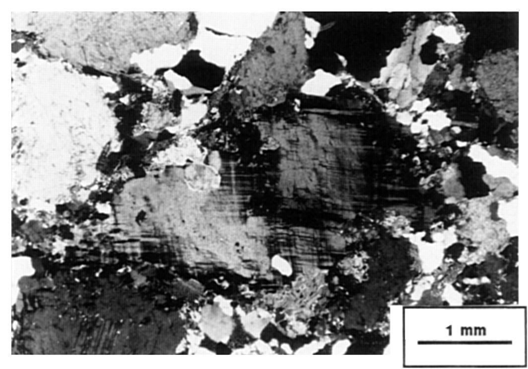
According to Midra et al. (1992a, pages 38-40): “The presence of microcline phenocrystals confers a porphyritic character to granodiorite. The rock is brownish grey in altered surface and light pink in fresh surface. In some places, granodiorite has centimetric bands rich in microcline phenocrystals. The orientation of these bands is parallel to foliation. The latter is very strong in places and is marked by the alignment of feldspars and biotite, and by the stretching of quartz. […] The Ouest Granodiorite generally has an augen texture, defined by the corroded and spindle appearance of feldspar grains. The main minerals observed are plagioclase, microcline, quartz and biotite. Accessory minerals are epidote, allanite, chlorite, muscovite, apatite and opaque minerals.”
At the NW end, Sharma and Lauzière (1986) and Charbonneau et al. (1991) describe an even-grained to porphyritic granodiorite with local pegmatite.
According to Midra et al. (1992a, pages 40-4 2): “Plagioclase forms millimetric crystals with corroded edges, giving it a spindle appearance. It locally displays K-feldspar exolution lamellae (antiperthite) and alters to sericite. Microcline occurs as phenocrystals with corroded borders such as plagioclase, or as interstitial millimetric crystals. Microcline’s twinnning is disturbed by the rock’s deformation. Where microcline and plagioclase come into contact, we note the presence of myrmekitic textures. Interstitial quartz forms stretched aggregates and has strong undulatory extinction. Crystal edges are usually sutured. Biotite occurs as zones or millimetric laths that mark the rock’s foliation. In places, it is destabilized in favour of chlorite and muscovite. Epidote occurs as euhedral crystals or aggregates and commonly rims euhedral allanite crystals; it is generally associated with biotite and opaque minerals.”
In the NW part, granodiorite may contain hornblende (Beach, 1940; Sharma and Lauzière, 1986).
The Renault pluton is an informal unit belonging to the Ouest Granodiorite, first circumscribed by Racicot et al. (1984) and then named by the Chown team (Chown et al., 1990, 1992, 2002; Bédard, 1992). The rock description of Sharma and Lauzière (1986) differs from that of Midra et al. (1992a) by the euhedral to subhedral shape of plagioclase and the presence of hornblende in addition to biotite. However, Simard et al. (2003a, b) did not retain this subdivision.
Thickness and distribution
The Ouest Granodiorite stretches 40 km to the NW, from the Gwillim Fault located 4 km NW of Rachel Lake (sheet 32G11-200-0201), to Renault Lake (sheet 32G13-200-0101). In this segment, its width varies from 2 km to 9 km. It then hooks eastward for 20 km to the Houghton Pluton ~10 km south of Trêve Lake (sheet 32G13-200-0102), where its width is <4 km. The thickest part, which is located at the far west of the unit and extends east of Renault Lake, corresponds to the Renault pluton. The current boundaries of the Ouest Granodiorite were compiled by Simard et al. (2003a, b, 2004a-c). However, these boundaries are not always reconcilable with SIGÉOM compilation outcrops, geological reports and previous scientific papers. The Ouest Granodiorite to the SE of Lapparent Lake was defined by Midra et al. (1992a) as the type area.
Dating
A U-Pb crystallization age of 2699.8 +2/-1.8 Ma was obtained in the Renault pluton (Mortensen, 1993) included in the Ouest Granodiorite by Simard et al. (2003a, b).
| Unit | Sample Numer | Isotopic System | Mineral | Crystallization Age (Ma) | (+) | (-) | Metamorphic Age (Ma) | (+) | (-) | Reference(s) |
| nAgro | RP-1 | U-Pb | Zircon | 2699.8 | 2 | 1.8 | Mortensen, 1993 | |||
| Titanite | 2681.6 | 6 | 6 | |||||||
| 2673.2 | 11.6 | 11.6 |
Stratigraphic Relationship(s)
The Ouest Granodiorite is an intrusion that cuts all volcanics of the Roy Group and adjacent units of the Lapparent Intrusive Suite. It is cut by aplite and pegmatite dykes.
According to Midra et al. (1992a, p. 38): “The Ouest Granodiorite mostly outcrops in the township of Lapparent. It is bounded to the north by tonalitic gneiss of the Lapparent Intrusive Suite and to the east by the Gwillim Fault. To the south, granodiorite changes to tonalite of the Rachel Pluton (I1D).”
Contact is marked by a series of granodiorite dykes cutting the Rachel Pluton tonalite. In contact with dykes, thin biotite plans develop. However, as noted above, the NW extension of the Ouest Granodiorite, as compiled by Simard et al. (2003a, b, 2004a-c) on the map, should be revised. According to the work of Lamothe (1987), outcrops observed at the southern edge of the unit correspond to tonalite and quartz diorite and could be associated with the Rachel Pluton. In the western part of the Ouest Granodiorite, on the north side of the Lapparent Intrusive Suite, granodiorite is in contact with the Bruneau and Blondeau formations to the north. Contact is marked by the presence of banded gneiss and by contact metamorphism forming an aureole >100 m thick (Charbonneau et al., 1988). Such granodiorite at the NW end was divided and identified as the Renault pluton (Racicot, 1984; Chown et al., 1990, 1992, 2002).
Paleontology
Does not apply.
References
Publications available through SIGÉOM Examine
CHARBONNEAU, J M., PICARD, C., DUPUIS-HEBERT, L., 1991. SYNTHESE GEOLOGIQUE DE LA REGION DE CHAPAIS-BRANSSAT (ABITIBI). MRN; MM 88-01, 202 pages, 13 plans.
DUQUETTE, G., 1970. STRATIGRAPHIE DE L’ARCHEEN ET RELATIONS METALLOGENIQUES DANS LA REGION DE CHIBOUGAMAU. MRN; ES 008, 25 pages, 1 plan.
GILBERT, J E., 1955. REGION DE BRANSSAT – DAINE, COMTE D’ABITIBI-EST. MRN; RG 064, 61 pages, 1 plan.
LAMOTHE, D., 1982. REGION DU LAC RELIQUE, DISTRICT DE CHIBOUGAMAU. MRN; DP-82-09, 2 plans.
LAMOTHE, D., 1987. GEOLOGIE DE LA REGION DU LAC RELIQUE – TERRITOIRE-DU-NOUVEAU-QUEBEC. MRN; MB 87-20, 46 pages, 2 plans.
M E R, 1983. RAPPORT D’ETAPE DES TRAVAUX EN COURS A LA DIVISION DU PRECAMBRIEN. ET 82-01, 269 pages, 2 plans.
MIDRA, R., CHOWN, E H., TAIT, L., 1992. GEOLOGIE DE LA REGION DU LAC DICKSON (BANDE CAOPATINA-DESMARAISVILLE). MRN; ET 90-01, 1 plan.
MIDRA, R., CHOWN, E H., TAIT, L., 1992. GEOLOGIE DE LA REGION DU LAC DICKSON (BANDE CAOPATINA-DESMARAISVILLE). MRN; MB 91-30, 65 pages.
MRNF, 2010. CARTE(S) GÉOLOGIQUE(S) DU SIGEOM – feuillet 32G. CG SIGEOM32G, 61 plans.
PICARD, C., 1985. GEOLOGIE DE LA REGION DU LAC INCONNU, ABITIBI-EST, QUEBEC. MRN; ET 83-16, 55 pages, 2 plans.
Other publications
BEACH, H.H., 1941a. Mechamego Lake, Abitibi Territory, Québec. Geological Survey of Canada; Map « A » 608A. doi.org/10.4095/107578
BEACH, H.H., 1941b. Michwacho Lake, Abitibi Territory, Québec. Geological Survey of Canada; Map « A » 623A. doi.org/10.4095/107645
BÉDARD, L.P., 1992. Géochimie et pétrographie du Pluton Archéen de Houghton en Abitibi nord Université du Québec à Chicoutimi; thèse de doctorat, 307 pages. constellation.uqac.ca/1446/1/1474497.pdf
CHOWN, E.H., DAIGNEAULT, R., MUELLER, W., 1990. Geological setting of the eastern extremity of the Abitibi Belt. In: Litho – Tectonic Framework and Associated Mineralization of the Eastern Extremity of the Abitibi Greenstone Belt, Quebec [Field Trip 3] (Guha, J., Chown, E.H. and Daigneault, R., editors). Geological Survey of Canada; Public File 2158, 131 pages. doi.org/10.4095/132283
CHOWN, E.H., DAIGNEAULT, R., MUELLER, W., MORTENSEN, J.K., 1992. Tectonic evolution of the Northern Volcanic Zone, Abitibi Belt, Québec. Canadian Journal of Earth Sciences, volume 29, pages 2211-2225. doi/pdf/10.1139/e92-175
CHOWN, E.H., HARRAP, R., MOUKHSIL, A., 2002. The role of granitic intrusion in the evolution of the Abitibi belt, Canada. Precambrian Research; volume 115, pages 291-310. doi.org/10.1016/S0301-9268(02)00013-X
MORTENSEN, J.K., 1993. U–Pb geochronology of the eastern Abitibi Subprovince. Part 1: Chibougamau-Matagami-Joutel region. Canadian Journal of Earth Sciences; volume 30, pages 11-22. doi.org/10.1139/e93-002
RACICOT, D., CHOWN, E.H., HANEL, T., 1984. Plutons of the Chibougamau-Desmaraisville belt: A preliminary survey. In: Chibougamau – Stratigraphy and Mineralization (Guha, J. and Chown, E.H., editors). Canadian institute of Mining and Metallurgy; Special Volume 34, pages 178-197.
RETTY, J.A., NORMAN, G.W.A., 1938. Chibougamau Sheet, West Half, Abitibi Territory, Quebec. Geological Survey of Canada; Map “A” 398A. doi.org/10.4095/108005
SHAW, G., 1940a. Lewis Lake, Abitibi Territory, Quebec. Geological Survey of Canada; Map « A » 555A. doi.org/10.4095/107574
SHAW, G., 1940b. Opawica Lake, Abitibi Territory, Quebec. Geological Survey of Canada; Map « A » 556A. doi.org/10.4095/107688
Suggested Citation
Ministère de l’Énergie et des Ressources naturelles (MERN). Ouest Granodiorite. Quebec Stratigraphic Lexicon. https://gq.mines.gouv.qc.ca/lexique-stratigraphique/province-du-superieur/granodiorite-de-ouest_en [accessed on Day Month Year].
Contributors
|
First publication |
Patrice Roy, P. Geo., M.Sc. patrice.roy@mern.gouv.qc.ca (redaction) Mehdi A. Guemache, P. Geo., Ph.D. (coordination); François Leclerc, P. Geo., Ph.D. (critical review); Mélina Langevin, B.Sc. and Simon Auclair, P. Geo., M.Sc. (editing); Céline Dupuis, P. Geo., Ph.D. (English version); Ricardo Escobar Moran (HTML editing). |