

First published: 26 April 2019
Last modified:
DISCLAIMER: This English version is translated from the original French. In case of any discrepancy, the French version shall prevail.
| Author(s): | Midra et al., 1992a |
| Age: | Neoarchean |
| Stratotype: | None |
| Type area: | MacIntosh Lake area (QTS sheet 32G11-200-0202) |
| Geological province: | Superior Province |
| Geological subdivision: | Abitibi Subprovince |
| Lithology: | Granodiorite |
| Category: | Lithodemic |
| Rank: | Lithodeme |
| Status: | Formal |
| Use: | Active |
- Lapparent Intrusive Suite
- Anville Pluton
- Houghton Pluton
- Est Tonalite
- Ouest Granodiorite
- Rachel Pluton
- MacIntosh Pluton
- Lapparent edge zone
- Lapparent tonalitic gneiss
- Lapparent gabbroic intrusion
Background
The granitoid mass of the Lapparent Intrusive Suite first appeared on the map of Retty and Norman (1938). Remick (1956, 1957) recognized different phases of the Lapparent Suite but did not differentiate them on the map. In 1970, Duquette described the Lapparent Pluton, to which the MacIntosh Pluton is associated, as a tonalite-diorite mass. Granodiorite of the MacIntosh Pluton was first identified on the map of Racicot et al. (1984). Nantel (1985) identified the pluton’s potential for dressed stone. The current pluton boundaries were defined by Midra et al. (1992a), who provided a more detailed description.
Description
According to Midra et al. (1992a):
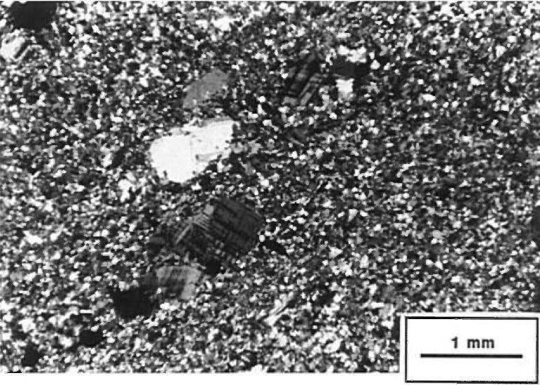
“[The MacIntosh Pluton] is whitish to reddish pink in altered surface and light pink to orange in fresh exposure. The rock is medium grained on the edge and very coarse in the core. Centimetric microcline and quartz phenocrystals give granodiorite a porphyritic appearance. Foliation in the rock is marked by the flattening of quartz grains, which are locally crenulated at the scale of the outcrop. In places, the pluton is cut by high deformation zones with a thickness of no more than one metre; the rock in this case is mylonitized. These observations suggest a late-tectonic age for the MacIntosh Pluton.
The pluton is cut in two parts by the Gwillim Fault. Only the eastern part outcrops. Hematitization that accompanies late and brittle N-E oriented faults is responsible for the reddish colour in some parts of the intrusion.
The texture is granular at the edge and quickly changes to porphyritic in the core. In high deformation zones that cut the pluton, mylonitic textures develop.
Microcline phenocrystals are centimetric and euhedral. Ovoid quartz (1.5-3 cm) is recrystallized into polycrystalline aggregates with edges of millimetric crystals being sutured. Microcline and quartz phenocrystals are embedded in a matrix composed mainly of plagioclase, microcline, quartz and epidote. Subhedral plagioclase (< 2 mm) displays twisted twinning and locally contains inclusions of epidote crystals. Microcline is millimetric and forms subhedral to euhedral crystals. Quartz, present in minor amounts, is interstitial. Epidote (clinozoisite) usually occurs as polycrystalline aggregates (2 mm) at the edges of plagioclase and in voids. Secondary minerals are chlorite, muscovite, sphene and opaque minerals.”
The MacIntosh Pluton has a uniform red colour that is particularly interesting for dressed stone (Nantel, 1985).
Thickness and distribution
Midra et al. (1992a) defined the MacIntosh Pluton around the lake of the same name, the eastern part of which represents the type area. The MacIntosh Pluton has an oval shape dissected by faults. It extends for 5 km towards the ENE along the Gwillim Fault, and is ~2 km wide.
Dating
None.
Stratigraphic Relationship(s)
The MacIntosh Pluton cuts the Est Tonalite and Lapparent tonalitic gneiss. The pluton is cut by the Gwillim Fault.
Paleontology
Does not apply.
References
Publications available through SIGÉOM Examine
DUQUETTE, G., 1970. ARCHEAN STRATIGRAPHY AND ORE RELATIONSHIPS IN THE CHIBOUGAMAU DISTRICT. MRN; ES 008(A), 23 pages, 1 plan.
DUQUETTE, G., 1970. STRATIGRAPHIE DE L’ARCHEEN ET RELATIONS METALLOGENIQUES DANS LA REGION DE CHIBOUGAMAU. MRN; ES 008, 25 pages, 1 plan.
MIDRA, R., CHOWN, E. H., TAIT, L., 1992. GEOLOGIE DE LA REGION DU LAC DICKSON (BANDE CAOPATINA-DESMARAISVILLE). MRN; ET 90-01, 1 plan.
MIDRA, R., CHOWN, E. H., TAIT, L., 1992. GEOLOGIE DE LA REGION DU LAC DICKSON (BANDE CAOPATINA-DESMARAISVILLE). MRN; MB 91-30, 65 pages.
NANTEL, S., 1985. Zones potentielles pour l’exploitation de la pierre de taille, région de Chibougamau. MRN; DP-85-04, 1 plan.
REMICK, J. H., 1956. PRELIMINARY REPORT ON THE ANVILLE – DROUET AREA, ABITIBI-EAST COUNTY. MRN; RP 322(A), 8 pages, 1 plan.
REMICK, J. H., 1956. RAPPORT PRELIMINAIRE SUR LA REGION D’ANVILLE – DROUET, COMTE D’ABITIBI-EST. MRN; RP 322, 11 pages, 1 plan.
REMICK, J. H., 1957. PRELIMINARY REPORT ON GUERCHEVILLE – LAPPARENT AREA, ABITIBI-EAST ELECTORAL DISTRICT. MRN; RP 343(A), 12 pages, 1 plan.
REMICK, J. H., 1957. RAPPORT PRELIMINAIRE SUR LA REGION DE GUERCHEVILLE – LAPPARENT, DISTRICT ELECTORAL D’ABITIBI-EST. MRN; RP 343, 15 pages, 1 plan.
Other publications
CHOWN, E.H., DAIGNEAULT, R., MUELLER, W. 1990. Geological setting of the eastern extremity of the Abitibi Belt, dans: Lithotectonic Framework and Associated Mineralization of the eastern Extremity of the Abitibi Greenstone Belt, Quebec [Field Trip 3] (éditeurs: J. Guha, E.H. Chown, R. Daigneault). Commission géologique du Canada, Dossier public 2158, 131 pages. https://doi.org/10.4095/132277
RACICOT, D., CHOWN, E.H., HANEL, T. 1984. Plutons of the Chibougamau-Desmaraisville belt: A preliminary survey, dans: Chibougamau – Stratigraphy and Mineralization, (Editeurs: J. Guha, and E.H. Chown). Canadian institute of Mining and Metallurgy; Special Volume 34, pages 178-197.
RETTY, J. A., NORMAN, G. W. H. 1938. Feuillet Chibougamau, moitié oust, territoire de l’Abitibi, Québec, Commission géologique du Canada, carte série “A” 398A, 1 carte. https://doi.org/10.4095/108005
Suggested Citation
Ministère de l’Énergie et des Ressources naturelles (MERN). MacIntosh Pluton. Quebec Stratigraphic Lexicon. http://gq.mines.gouv.qc.ca/lexique-stratigraphique/province-du-superieur/pluton-de-macintosh_en [accessed on Day Month Year].
Contributors
|
First publication |
Patrice Roy, P. Geo., M.Sc. patrice.roy@mern.gouv.qc.ca (redaction) Mehdi A. Guemache, P. Geo., Ph.D. (coordination); François Leclerc, P. Geo., Ph.D. (critical review); Mélina Langevin, B.Sc. and Simon Auclair, P. Geo., M.Sc. (editing); Céline Dupuis, P. Geo., Ph.D. (English version); André Tremblay (HTML editing). |