


Southeastern Churchill Province, Nunavik, Quebec, Canada: Geological Synthesis
Isabelle Lafrance, Benoit Charette and Marc-Antoine Vanier
BG 2018-12
Translated on 14 January 2020

Since 2009, the Ministère's work, in collaboration with its partners, the Geological Survey of Canada (GSC), Department of Mines and Energy of Newfoundland and Labrador and several universities, has identified six distinct lithotectonic domains in the Southeastern Churchill Province. Five of these domains are or will each be the subject of a Geological Bulletin and stratigraphic record. These include the Rachel-Laporte, Baleine, George (Charette et al., 2018), Mistinibi-Raude (Charette et al., 2019) and Falcoz domains. The sixth domain, the Labrador Trough, has already been synthesized (Clark and Wares, 2004). A seventh domain in the Nain Province, the Burwell, was also described during this work.
Geological Bulletins for each lithotectonic domain present different sections on lithostratigraphy (including a stratigraphic diagram), lithogeochemistry, metamorphism, structure (including a structural cross-section) and regional tectonics of the relevant domain. The main prospective environments for exploration and types of mineralization are also described. All SECP geological units now have a stratigraphic record, and large deformation zones are presented in the Structural Lexicon of Quebec.
Methodology
The Southeastern Churchill Province (SECP) was mapped using the established method for surveys in isolated areas without road access. Geological mapping at 1:250 000 scale covering most of the territory was conducted by teams of seven to eight geologists and five to eight students during the summers of 2011 to 2017 (Simard et al., 2013; Lafrance et al., 2014; 2015; 2016; Charette et al., 2016; Mathieu et al., 2018). Field checks were conducted in the southern part of the SECP in the summer of 2016 by a team of four geologists and three students. The 2017 summer mapping covered the Quebec portion of the Burwell Lithotectonic Domain, which is part of the Nain Province. The Ministère’s previous mapping work has been considered in the processing of data, including that conducted in 1998 (Verpaelst et al., 2000), 2009 and 2010 (Hammouche et al., 2011, 2012).
The synthesis produced a new, simplified geological map, subdividing the SECP into broad lithotectonic domains and updating data elements presented in the table opposite.
| Element | Approximate Number (Preliminary) |
|---|---|
| Described outcrop(“geofiche”) | 12685 |
| Total lithogeochemical analysis | 2382 |
| Lithogeochemical analysis of metals of economic interest | 833 |
| Geochronological analysis | 172 |
| Covered thin section | 2006 |
| Polished thin section | 242 |
| Sodium cobaltinitrite stain | 749 |
| Stratigraphic unit | 96 |
| Metallic mineralization record | 310 |
Previous Work
Several geological surveys have been conducted in the SECP at different scales by the Ministère. The main mapping campaigns took place in the northern and southern parts since access is easier. This work took place primarily in the 1950s and 1980s and include several master’s and doctoral theses. During the 1960s and 1970s, the Geological Survey of Canada also conducted several regional geological mapping projects, including 1:250 000-scale mapping that covered the entire SECP in Quebec and Labrador (Taylor, 1979). The complete list of this work is presented in the “Previous Work” sections of the Geological Bulletins of the different lithotectonic domains involved in this work (Rachel-Laporte, Baleine, George, Mistinibi-Raude and Falcoz).
During the 1980s, the concerted efforts of several geologists working for various geological surveys and departments across Canada resulted in the development of tectonic models for the Trans-Hudsonian Orogen (Hoffman, 1988, 1990b). This work has led to numerous papers in a special volume published by the Geological Association of Canada (1990, Special Paper 37), one of which deals specifically with the SECP. During the same period, another series of papers on the SECP was published in a special issue of Geoscience Canada (1990, Volume 17, Number 4). In the early 1990s, the completion of a deep seismic survey in Ungava Bay and the Labrador Sea (Lithoprobe Program, ECSOOT transect) coupled with work on isotopic geochemistry, geochronology and structural geology resulted in a better general interpretation of the SECP. Among other things, this work helped link the evolution of the Canadian Shield with that of Greenland. The latest interpretations of this work have been published as several papers in a full issue of the Canadian Journal of Earth Sciences (2002a, Volume 39, Number 5).
| Author(s) | Type of Work | Contribution |
|---|---|---|
| Low, 1896 | Geological reconnaissance | First geological survey work in the Southeastern Churchill Province |
| Taylor, 1979 | Large-scale regional geological mapping | First systematic geological mapping across the Churchill Province |
|
Hoffman, 1990a; James et al., 1996; James et Dunning, 2000; Van der Leeden et al., 1990; Wardle et al., 1990a, 1990b, 2002a; Wardle et van Kranendonk, 1996; Wardle and Hall, 2002; Corrigan et al., 2018 |
Compilation, geochronology, geological synthesis and geodynamic implications |
Context and geotectonic evolution of the SECP |
|
Stockwell, 1961, 1982; Hoffman, 1988, 1990b; St-Onge et al., 1998, 2009; Corrigan et al., 2009; Wardle et al., 2002b; Lewry and Collerson, 1990 |
Compilation, geochronology, geological synthesis and geodynamic implications | Characterization of the Trans-Hudsonian Orogen |
| GDS, 2009; D'Amours and Intissar, 2012a, 2012b; D'Amours and Intissar, 2013a, 2013b; Intissar et al., 2014a, 2014b; Intissar, 2018a, 2018b | Geophysical surveys | Magnetic and spectrometric aerial surveys of most of the Southeastern Churchill Province |
Geological Context

The Southeastern Churchill Province (SECP) is interpreted as a branch of the Trans-Hudsonian Orogen, a large Paleoproterozoic orogenic belt that extends from North Dakota to Greenland. This large orogenic system is part of a long period of global convergence that led to the formation of the Laurentia Craton (1.97-1.82 Ga; Hoffman, 1990a) and later to the Columbia Supercontinent (Nuna).
The Trans-Hudsonian Orogen was named by Hoffman (1981) to define the Paleoproterozoic collision between the Superior and Archean domains of the NW part of the Churchill. The type area is located in northern Manitoba and Saskatchewan and includes both external and internal zones, represented respectively by Archean continental margins and a Proterozoic juvenile crust. A broader definition has been adopted by Lewry et al. (1985) and Lewry and Collerson (1990), which includes not only Paleoproterozoic metamorphic rocks associated with this collision, but also the large metamorphic and structural imprint area affecting Archean to Paleoproterozoic Churchill rocks. This more inclusive definition has been retained in the literature. Corrigan et al. (2009) notes that it provides a better understanding of the orogenic system and the near-continuous tectonothermal imprint formed during the collision between the Superior Craton, the Reindeer Zone and a continental amalgam comprising the Slave, Rae and Hearne cratons. The latter two, limited by the Snowbird Tectonic Zone, represent the western portion of the Churchill Province.
Rocks affected by the Trans-Hudsonian Orogen are divided into three main branches (Hoffman, 1988): 1) the SW branch, west of Hudson Bay; 2) the NE branch, in the central section, north of Hudson Strait; and 3) the SE branch, south of Ungava Bay. In its centre, the Trans-Hudsonian Orogen is masked by sedimentary rocks of the Hudson Bay Paleozoic basin. The SE branch, which separates the Superior and North Atlantic cratons, is commonly interpreted as the Quebec portion of the Churchill Province (hence its SECP acronym). However, the correlation between these two parts is still under discussion (Bourlon et al., 2002; St-Onge et al., 2002; Wardle et al., 2002a). This large orogenic ensemble is also divided into three tectonic divisions by Corrigan et al. (2009): the Churchill margin (peri-Churchill), the Reindeer Zone and the Superior margin (peri-Superior). The peri-Churchill domain would have experienced progressive continental growth prior to the collision with the Superior Craton. This growth is marked by the accretion of microcontinents (Hearne, Meta Incognita/Core Zone, Sugluk) and arc terranes (La Ronge-Lynn Lake) to the Slave-Rae Craton. The Reindeer Zone includes elements that are exotic to the Churchill and Superior and present in the Manikewan Ocean: primitive to evolved oceanic arcs, back-arc basins, crust and oceanic plateaus, and Archean fragments such as the Sask Craton. These ensembles would have amalgamated with the peri-Superior domain during the final collision phase of the Trans-Hudsonian Orogen.
The SECP represents an area of this vast compression where the North Atlantic Craton (mainly exposed in Labrador and Greenland) and exotic fragments collided with the eastern margin of the Superior. This area is interpreted by several authors to be correlated with the lithologies and geological context observed on Baffin Island and in the Ungava Peninsula (St-Onge et al., 2009; Wardle et al., 2002a and references cited; correlative charter of Wardle et al., 2002b).
In Quebec, the SECP is limited by the Archean Superior Craton to the west, and by the Nain Province (North Atlantic craton and Burwell Lithotectonic Domain) and Makkovik Province to the east. Its contact with the Nain Province is partly masked by large Mesoproterozoic intrusions. The SECP is cut to the south by the Grenville Province.
Lithotectonic Subdivisions
The SECP has long been considered to have a tripartite structure (Hoffman, 1990a; van der Leeden et al., 1990; Wardle et al., 1990a) consisting of the Archean Core Zone remobilized in the Paleoproterozoic, bordered by two orogens:
- the Torngat Orogen (1.89-1.81 Ga) in the east, which corresponds to the suture between the Churchill and Nain provinces;
- the New Quebec Orogen (1.82-1.77 Ga) to the west, representing the suture between the Churchill and Superior provinces (Hoffman, 1990a).
The compression generated by these collisions is responsible for the regional NW-SE to N-S structural grain which affects most of the SECP. However, recent work of the Ministère (Verpaelst et al., 2000; Hammouche et al., 2011, 2012; Simard et al., 2013; Lafrance et al., 2014, 2015, 2016; Charette et al., 2016; Mathieu et al., 2018), the GSC (Corrigan et al., 2015a, b, 2018) and the academic community (Charette, 2016; Vanier et al., 2017, 2018; Godet et al., in preparation) reveal that this three-part representation of the SECP is inadequate.
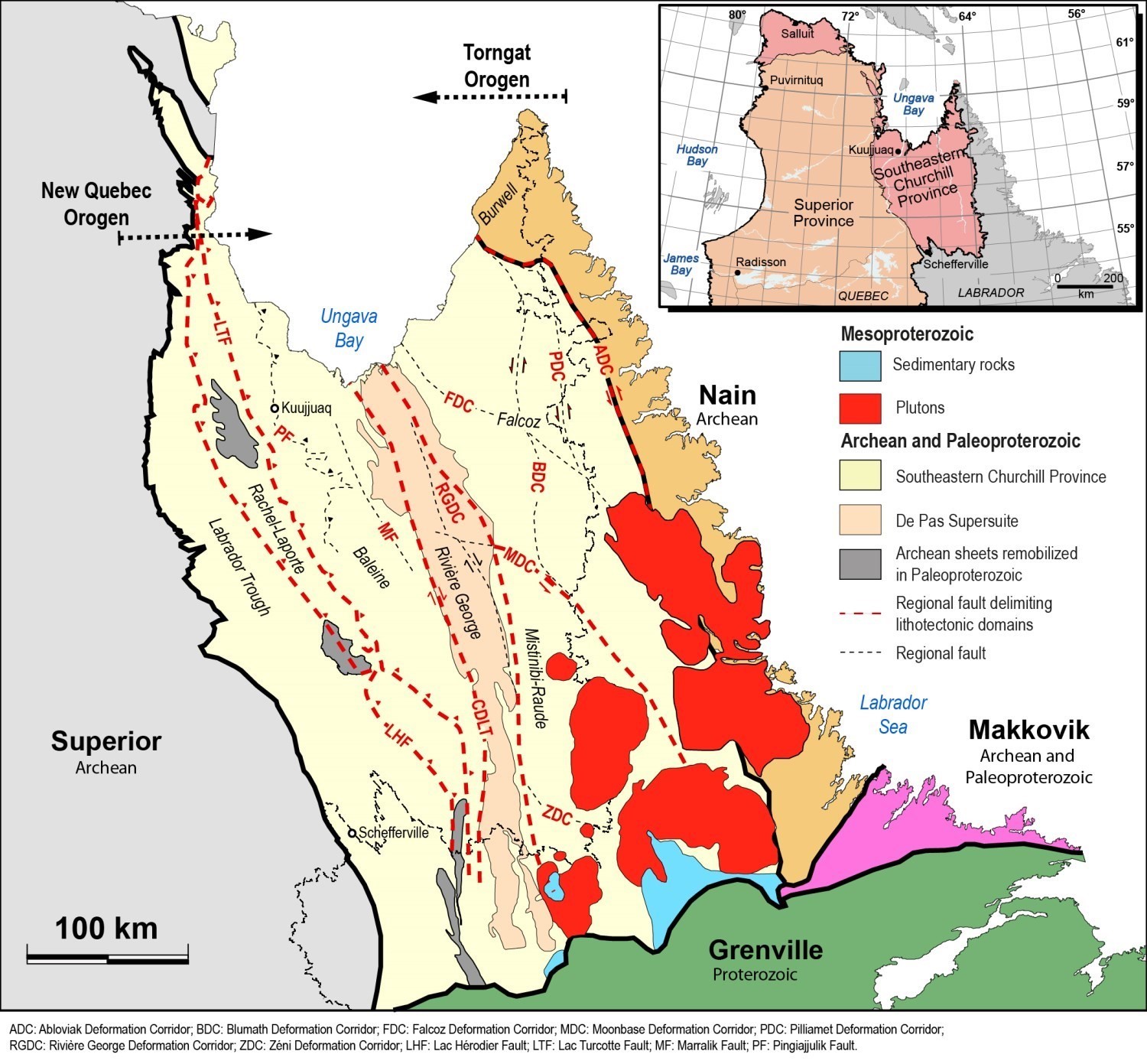
The new results propose, as part of the SECP synthesis, a division into six distinct lithotectonic domains that are, from west to east: the Labrador Trough and the Rachel-Laporte, Baleine, George, Mistinibi-Raude and Falcoz domains. The Labrador Trough has not been the subject of this bulletin because a lithotectonic and metallogenic synthesis is already available (Clark and Wares, 2004). The other five domains are described in detail in their respective Geological Bulletin.
According to Wardle et al. (2002a), the Core Zone represents an Archean microcontinent characterized by a 35 to 40 km thick crust. It is attached to a fragment of the Archean Superior Province (Kuujjuaq Domain of Wardle) separated during a period of rift opening that led to the formation of the Labrador Trough at the beginning of the Paleoproterozoic (2.17-1.89 Ga). Recent field observations, isotopic geochemistry and geochronology have defined four different lithotectonic domains forming the amalgamated Core Zone-Kuujjuaq Domain block of Wardle et al. (2002a), i.e. the Baleine, George, Mistinibi-Raude and the western part of the Falcoz Domain. These domains with distinct lithological characteristics, limited by major shear zones, also contrast by their tectonometamorphic evolution and their crystallization age range. The term “Core Zone”, used in the text below for easy reading, represents a block composed of lithotectonic domains of different origins amalgamated by tectonic processes. We believe that the boundaries of this block evolved throughout its amalgamation. In its final state, it includes all lithologies of lithotectonic domains located east of the Labrador Trough up to the Nain Province, which is represented in Quebec by the Burwell Lithotectonic Domain. It also includes the Rachel-Laporte and Falcoz domains, previously assigned to the New Quebec and Torngat orogens respectively. The terms “Torngat Orogen” and “New Quebec Orogen” are no longer used as lithotectonic divisions. Rather, we consider that the imprint of these orogeneses is not limited to domains previously included in these divisions, but continues within the different lithotectonic domains previously grouped under the term “Core Zone”.
The Torngat Orogen is the result of a series of tectonometamorphic events that took place in the Paleoproterozoic (1.89-1.81 Ga; Van Kranendonk and Ermanovics, 1990; Van Kranendonk, 1996; Wardle and Van Kranendonk, 1996; Ermanovics and Van Kranendonk, 1998; Wardle et al., 2002a; Charette, 2016). It begins with the oblique collision between the Core Zone and the Archean North Atlantic Craton, which doubles the thickness of the crust between 1890 Ma and 1850 Ma, and develops a double-verging transpressive structure characterized by a subvertical central axis (Rivers et al., 1996; Wardle et al., 2002a). This process generated upper amphibolite to granulite facies metamorphic conditions. This event is followed by strike-slip or transpressure deformation between 1845 Ma and 1822 Ma, and then by cooling allowing leucosome to crystallize around 1810 Ma. A reactivation and uplift event around 1790-1780 Ma was identified at the eastern end of the orogen (Rivers et al., 1996; Van Kranendonk, 1996). In Quebec, Verpaelst et al. (2000) limited the Torngat Orogen to an assemblage of granulitic gneiss of various origins, completely remobilized during the orogenesis and dominated by a large system of sinistral shear zones. This area now corresponds to the eastern part of the Falcoz Lithotectonic Domain. However, recent tectonometamorphic studies (Charette, 2016; Godet et al., in preparation) indicate that the tectonothermal imprint of the Torngat Orogen is not limited to granulitic rocks, but extends westward to the Baleine Lithotectonic Domain. Only the Mistinibi-Raude Domain appears to have escaped the metamorphic imprint of this orogenesis.
The amalgamated block, consisting of the Core Zone and the North Atlantic Craton, subsequently collided obliquely with the Superior Craton during the New Quebec Orogenesis. On the eastern margin of the Superior Craton, the volcano-sedimentary belt of the Labrador Trough (and its hinterland) was folded and thrust toward the WSW on the craton. It resulted is duplex structures and exposure of the Archean basement by structural domes (thick-skinned tectonics), resulting in a burial and greenschist to amphibolite facies metamorphism of volcano-sedimentary sequences of the Labrador Trough and Rachel-Laporte Domain. The eastern boundary of the New Quebec Orogen was previously marked by the Kuujjuaq Domain (also known as Kuujjuaq Terrane; Wardle et al., 1990a; Perrault and Hynes, 1990). It is now included in the Baleine Lithotectonic Domain, which extends eastward to the Lac Tudor Shear Zone. Clark and Wares (2004) standardized stratigraphic nomenclature of the Quebec portion of the Labrador Trough and divided the Kaniapiskau Supergroup, which consists of all the groups and formations of the Labrador Trough, into three cycles: two volcano-sedimentary cycles at the base overlain by a cycle of molasse-type metasedimentary rocks.
The New Quebec Orogen contrasts greatly in deformation style and metamorphic grade with the high-temperature deformed granulitic units of the Torngat Orogen. The Core Zone is dissected by large NNW-SSE to N-S mainly dextral shear zones such as the Rivière George and Lac Tudor shear zones. Approaching the Torngat Orogen, sinistral NW-SE shear zones, such as the Falcoz and Moonbase shear zones, could represent shear networks coupled with dextral shearing (Vanier et al., 2018; Vanier, 2019).
New data acquired in the SECP showed that the tectonometamorphic evolution of this geological province in the Paleoproterozoic was not simply the result of the development of orogenic belts located on both sides of the Core Zone, but that the latter was in fact a vast suprasolidus domain. Field observations, geochronology work and tectonic studies made in recent years show that the Archean gneissic basement and sedimentary cover have been migmatized in the Paleoproterozoic. In fact, evolved partial melting products have crystallization ages generally between 1820 Ma and 1810 Ma. Also, several evidence of metamorphic events before collision with the Superior Craton was found in the SECP, suggesting that the evolution of the SECP is more complex than previously thought.
| Authors |
Isabelle Lafrance, P.Geo., M.Sc. isabelle.lafrance@mern.gouv.qc.ca Marc-Antoine Vanier, Jr.Eng. in geology marc-antoine.vanier@mern.gouv.qc.ca |
| Geomatics | Julie Sauvageau |
| Linguistic revision | Simon Auclair, P.Geo., M.Sc. |
| Critical review | Patrice Roy, P.Geo., M.Sc. |
| English version | Céline Dupuis, P.Geo., Ph.D. |
| Organization | General Direction of Géologie Québec, Ministère de l'Énergie et des Ressources naturelles, Government of Québec |
Acknowledgements:
This Geological Bulletin was made possible through the cooperation of many people who have been actively involved in the various stages of the project, including geologists and students who participated in field campaigns between 2009 and 2017, professors and students who have dealt with specific and regional issues in university studies, as well as our partners at the Geological Survey of Canada, Geotop and Jack Satterly Geochronology Laboratory.
References
Publications Available Through Sigéom Examine
CHARETTE, B., LAFRANCE, I., VANIER, M.-A. 2018. DOMAINE DE GEORGE, SUD-EST DE LA PROVINCE DE CHURCHILL, NUNAVIK, QUEBEC, CANADA : SYNTHESE DE LA GEOLOGIE. MERN. BG 2018-11.
CHARETTE, B., LAFRANCE, I., VANIER, M.-A. 2019. DOMAINE DE MISTINIBI-RAUDE, SUD-EST DE LA PROVINCE DE CHURCHILL, NUNAVIK, QUEBEC, CANADA : SYNTHESE DE LA GEOLOGIE. MERN. BG 2019-07.
CLARK, T., WARES, R., 2004. SYNTHESE LITHOTECTONIQUE ET METALLOGENIQUE DE L'OROGENE DU NOUVEAU-QUEBEC (FOSSE DU LABRADOR). MRNFP; MM 2004-01, 182 pages, 1 map.
D'AMOURS, I., INTISSAR, R. 2012. LEVE MAGNETIQUE ET SPECTROMETRIQUE AEROPORTE DANS LE SECTEUR DU LAC LE MOYNE, PROVINCE DE CHURCHILL. MRNF. DP 2011-06, 8 pages and 200 plans.
D'AMOURS, I., INTISSAR, R. 2012. LEVE MAGNETIQUE ET SPECTROMETRIQUE AEROPORTE DE LA RIVIERE KOKSOAK, PROVINCE DE CHURCHILL. MRNF. DP 2011-07, 8 pages and 180 plans.
D'AMOURS, I., INTISSAR, R. 2013. LEVE MAGNETIQUE ET SPECTROMETRIQUE AEROPORTE DANS LE SECTEUR DE LA RIVIERE A LA BALEINE, PROVINCE DE CHURCHILL. MRN. DP 2013-03, 10 pages and 170 plans.
D'AMOURS, I., INTISSAR, R. 2013. LEVE MAGNETIQUE ET SPECTROMETRIQUE AEROPORTE DANS LE SECTEUR DU LAC ROMANET, PROVINCE DE CHURCHILL. MRN. DP 2013-02, 10 pages and 280 plans.
GEO DATA SOLUTIONS GDS INC, COMMISSION GEOLOGIQUE DU CAN. 2009. LEVE AEROMAGNETIQUE HAUTE RESOLUTION A L'EST DE SCHEFFERVILLE. DP 2009-04, 96 pages and 16 plans.
HAMMOUCHE, H., LEGOUIX, C., GOUTIER, J., DION, C., PETRELLA, L. 2011. GEOLOGIE DE LA REGION DU LAC BONAVENTURE. MRNF. RG 2011-03, 37 pages and 1 plan.
HAMMOUCHE, H., LEGOUIX, C., GOUTIER, J., DION, C., 2012. GEOLOGIE DE LA REGION DU LAC ZENI. MRN; RG 2012-02, 35 pages, 1 map.
INTISSAR, R. 2018a. LEVE MAGNETIQUE ET SPECTROMETRIQUE HELIPORTE DANS LE SECTEUR DE LA RIVIERE BARNOIN, EST DE LA BAIE D'UNGAVA. MERN, NOVATEM. DP 2018-02, 7 pages and 10 plans.
INTISSAR, R. 2018b. LEVE MAGNETIQUE ET SPECTROMETRIQUE HELIPORTE DANS LE SECTEUR DE LA RIVIERE GEORGE, EST DE LA BAIE D'UNGAVA. MERN, NOVATEM. DP 2018-01, 7 pages and 10 plans.
INTISSAR, R., BENAHMED, S., D'AMOURS, I. 2014a. LEVE MAGNETIQUE ET SPECTROMETRIQUE AEROPORTE DANS LE SECTEUR NORD DE LA RIVIERE GEORGE, PARTIE SUD-EST DE LA PROVINCE DE CHURCHILL. MRN. DP 2014-02, 9 pages and 160 plans.
INTISSAR, R., BENAHMED, S., D'AMOURS, I. 2014b. LEVE MAGNETIQUE ET SPECTROMETRIQUE AEROPORTE DANS LE SECTEUR SUD DE LA RIVIERE GEORGE, PARTIE SUD-EST DE LA PROVINCE DE CHURCHILL. MRN. DP 2014-01, 9 pages and 250 plans.
LAFRANCE, I., VANIER, M.-A., 2021. Domaine lithotectonique de Rachel-Laporte, sud-est de la Province de Churchill, Nunavik, Québec, Canada: synthèse de la géologie. MERN; BG 2021-01, 4 maps.
LAFRANCE, I., VANIER, M.-A., 2022. Domaine lithotectonique de Falcoz, sud-est de la Province de Churchill, Nunavik, Québec, Canada: synthèse de la géologie. MERN; BG 2022-01, 1 map.
LAFRANCE, I., BANDYAYERA, D., BILODEAU, C. 2015. GEOLOGIE DE LA REGION DU LAC HENRIETTA (SNRC 24H). MERN. RG 2015-01, 62 pages and 1 plan.
LAFRANCE, I., BANDYAYERA, D., CHARETTE, B., BILODEAU, C., DAVID, J. 2016. GEOLOGIE DE LA REGION DU LAC BRISSON (SNRC 24A). MERN. RG 2015-05, 64 pages and 1 plan.
LAFRANCE, I., SIMARD, M., BANDYAYERA, D. 2014. GEOLOGIE DE LA REGION DU LAC SAFFRAY (SNRC 24F, 24G). MRN. RG 2014-02, 51 pages and 1 plan.
LAFRANCE, I., VANIER, M.-A., CHARETTE, B., 2020. Domaine lithotectonique de Baleine, sud-est de la Province de Churchill, Québec, Canada: synthèse de la géologie. MERN; BG 2020-07, 4 maps.
MATHIEU, G., LAFRANCE, I., VANIER, M.-A., 2018. Géologie de la région de pointe Le Droit, Province de Nain et sud-est de la Province de Churchill, Nunavik, Québec, Canada. MERN; BG 2018-07, 4 maps
SIMARD, M., LAFRANCE, I., HAMMOUCHE, H., LEGOUIX, C. 2013. GEOLOGIE DE LA REGION DE KUUJJUAQ ET DE LA BAIE D'UNGAVA (SNRC 24J, 24K). MRN. RG 2013-04, 62 pages and 1 plan.
VANIER, M.-A., GODET, A., GUILMETTE, C., HARRIS, L B., CLEVEN, N.R., CHARETTE, B., LAFRANCE, I. 2018. Extrusion latérale en croûte moyenne dans le sud-est de la Province de Churchill démontrée par les interprétations géophysiques, l'analyse structurale et les pétrofabriques du quartz. UNIVERSITE LAVAL, INRS, MERN. MB 2018-12, 58 pages.
VANIER, M-.A., GUILMETTE, C., HARRIS, L., GODET, A., CLEVEN, N., CHARETTE, B., LAFRANCE, I. 2017. ANALYSE STRUCTURALE ET MICROSTRUCTURES DES ZONES DE CISAILLEMENT DE LA RIVIERE GEORGE ET DU LAC TUDOR. UNIVERSITE LAVAL, INRS, MERN. MB 2017-12, 50 pages.
VERPAELST, P., BRISEBOIS, D., PERREAULT, S., SHARMA, K.N.M., DAVID, J. 2000. GEOLOGIE DE LA REGION DE LA RIVIERE KOROC (24I) ET D'UNE PARTIE DE LA REGION D'HEBRON (14L). MRN. RG 99-08, 62 pages and 10 plans.
Other Publications
BOURLON, E., MARESCHAL, J.C., ROEST, W.R., TELMAT, H., 2002. Geophysical correlations in the Ungava Bay area: Canadian Journal of Earth Sciences; volume 39, pages 625–637. doi.org/10.1139/e01-098.
CHARETTE, B., 2016. Long-lived Anatexis in the Exhumed Middle Crust from the Torngat Orogen and Eastern Core Zone: Constraints from Geochronology, Petrochronology, and Phase Equilibria Modeling. University of Waterloo; mémoire de maîtrise, 427 pages. Source
CHARETTE, B., GODET, A., GUILMETTE, C., DAVIS, D.W., VERVOORT, J., KENDALL, B., LAFRANCE, I., BANDYAYERA, D., YAKYMCHUK, C., 2021. Long-lived anatexis in the exhumed middle crust of the Torngat Orogen: Constraints from phase equilibria modeling and garnet, zircon, and monazite geochronology. Lithos; volume 388-389, article 106022. doi.org/10.1016/j.lithos.2021.106022
CORRIGAN, D., PEHRSSON, S., WODICKA, N., DE KEMP, E., 2009. The Palaeoproterozoic Trans-Hudson Orogen; a prototype of modern accretionary processes., in Ancient orogens and modern analogues (Murphy, J.B., Keppie, J.D., and Hynes, A.J., editors). Geological Survey of Canada, Ottawa, ON, Canada, Geological Society of London, London, United Kingdom; volume 327, pages 457–479. doi.org/10.1144/SP327.19.
CORRIGAN, D., WODICKA, N., McFARLANE, C., LAFRANCE, I., VAN ROOYEN, D., BANDYAYERA, D., BILODEAU, C., 2018, Lithotectonic Framework of the Core Zone, Southeastern Churchill Province, Canada: Geoscience Canada; volume 45, pages 1–24. doi.org/10.12789/geocanj.2018.45.128.
DEWEY, J.F., BURKE, K. C., 1973. Tibetan, Variscan, and Precambrian basement reactivation: products of continental collision. The Journal of Geology; volume 81, pages 683-692. doi.org/10.1086/627920
ERMANOVICS, I., VAN KRANENDONK, M., 1998. Geology of the Archean Nain Province and Paleoproterozoic Torngat Orogen in a transect of the North River-Nutak map areas, Newfoundland (Labrador) and Quebec: Ottawa, ON, Canada. Geological Survey of Canada; Bulletin 497, pages 1-156. doi.org/10.4095/209574.
GODET, A., 2020. Styles métamorphique et tectonique au Paléoprotérozoïque : exemple du sud-est de la province du Churchill, Québec, Canada. Université Laval; thèse de doctorat, 396 pages. Source
GODET, A., GUILMETTE, C., LABROUSSE, L., DAVIS, D.W., VANIER, M.-A., LAFRANCE, I., CHARETTE, B., 2020a. Contrasting P-T-t paths reveal a metamorphic discontinuity in the New Quebec Orogen: insights into Paleoproterozoic orogenic processes. Precambrian Research; volume 342, article 105675. doi.org/10.1016/j.precamres.2020.105675
GODET, A., GUILMETTE, C., LABROUSSE, L., DAVIS, D.W., MATTHIJS, A.S., CUTTS, J.A., VANIER, M.-A., LAFRANCE, I., CHARETTE, B., 2020b. Complete metamorphic cycle and long lived anatexy in the ~2.1 Ga Mistinibi Complex, Canada. Journal of Metamorphic Geology; volume 38, pages 235-264. doi.org/10.1111/jmg.12521
GODET, A., GUILMETTE, C., LABROUSSE, L., SMITT, M.A., CUTTS, J.A., DAVIS, D.W., VANIER, M.A., 2021. Lu–Hf garnet dating and the timing of collisions: Palaeoproterozoic accretionary tectonics revealed in the Southeastern Churchill Province, Trans‐Hudson Orogen, Canada. Journal of Metamorphic Geology; volume 20. doi.org/10.1111/jmg.12599
GOULET, N., CIESIELSKI, A., 1990. The Abloviak shear zone and the NW Torngat Orogen, eastern Ungava Bay, Quebec: Geoscience Canada; volume 17, pages. 269–272. Source
HENRIQUE-PINTO, R., GUILMETTE, C.,BILODEAU, C., McNICOLL, V., 2017. Evidence for transition from a continental forearc to a collisional pro-foreland basin in the eastern Trans-Hudson Orogen: Detrital zircon provenance analysis in the Labrador Trough, Canada. Precambrian Research; volume 296, pages 181-194. doi.org/10.1016/j.precamres.2017.04.035
HENRIQUE-PINTO, R., GUILMETTE, C., BILODEAU, C., STEVENSON, R., CARVALHO, B.B., 2019. Petrography, geochemistry, and Nd isotope systematics of metaconglomerates and matrix-rich metasedimentary rocks: implications for the provenance and tectonic setting of the Labrador Trough, Canada. Canadian Journal of Earth Sciences; volume 56, pages 672-687. doi.org/10.1139/cjes-2018-0187
HOFFMAN, P.F., 1981. Autopsy of Athapuscow aulacogen: a failed arm affected by three collisions. In: Proterozoic Basins of Canada (Campbell, F.H.A., editor). Geological Survey of Canada; Paper 81-10, pages 97–102. doi.org/10.4095/109385
HOFFMAN, P.F., 1988. United Plates of America, The Birth of a Craton: Early Proterozoic Assembly and Growth of Laurentia. Annual Review of Earth and Planetary Sciences; volume 16, pages 543–603. doi.org/10.1146/annurev.ea.16.050188.002551.
HOFFMAN, P.F., 1990a. Subdivision of the Churchill Province and extent of the Trans-Hudson Orogen. In: The Early Proterozoic Trans-Hudson Orogen of North America: Lithotectonic Correlations and Evolution (Lewry, J.F. and Stauffer, M.R., editors). Geological Association of Canada; Special Paper 37, pages 15–39.
HOFFMAN, P.F. 1990b. Dynamics of the tectonic assembly of northeast Laurentia in geon 18 (1.9-1.8 Ga). Geoscience Canada; volume 17, pages 222–226.
ISNARD, H., PARENT, M., BARDOUX, M., DAVID, J., GARIÉPY, C., STEVENSON, R.K., 1998. U-Pb, Sm-Nd and Pb-Pb isotope geochemistry of the high-grade gneiss assemblages along the southern shore of Ungava Bay. In Wardle R.J., Hall, J. (editors), Eastern Canadian Shield Onshore–Offshore (ECSOOT), Transect Meeting, 1998. The University of British Columbia, Lithoprobe Secretariat; Report 68, pages 67-77.
JAMES, D.T., CONNELLY, J.N., WASTENEYS, H.A., KILFOIL, G.J., 1996. Paleoproterozoic lithotectonic divisions of the southeastern Churchill Province, western Labrador: Canadian Journal of Earth Sciences; volume 33, pages 216–230. doi.org/10.1139/e96-019.
JAMES, D.T., DUNNING, G.R., 2000. U-Pb geochronological constraints for Paleoproterozoic evolution of the core zone, southeastern Churchill Province, northeastern Laurentia: Precambrian Research; volume 103, pages 31–54. doi.org/10.1016/S0301-9268(00)00074-7.
LEWRY, J.F., COLLERSON, K.D., 1990. The Trans-Hudson Orogen: extent, subdvisions and problems., in The Early Proterozoic Trans-Hudson Orogen of North America: Lithotectonic Correlations and Evolution (Lewry, J.F., and Stauffer, M.R., editors).,Geological Association of Canada; Special Paper 37, pages 1–14.
LEWRY, J.F., SIBBALD, T.I., SCHLEDEWITZ, D.C., 1985. Variation in character of Archean rocks in the western Churchill Province and its significance. In: Evolution of Archean Supracrustal Sequences (Ayres, L.D., Thurston, P.C., Card, K.D. and Weber, W.). Geological Association of Canada; Special Paper 28, p. 239–261.
LOW, A.P., 1896. Report on explorations in the Labrador Peninsula along the East Main, Koksoak, Hamilton, Manicuagan and portions of other rivers in 1892-93-94-95. Geological Survey of Canada; volume 8, 387 pages. doi.org/10.4095/293888
PERREAULT, S., HYNES, A., 1990. Tectonic evolution of the Kuujjuaq terrane, New Quebec Orogen: Geoscience Canada; volume 17, pages. 238–240. Source
RIVERS, T., FLEMMING, M., SCOTT, D.J., CAMPBELL, L.M., GOULET, N., 1996. Torngat Orogen – a Palaeoproterozoic example of a narrow doubly vergent collisional orogen. Geological Society, London; Special Publications, volume 112, pages 117-136. doi.org/10.1144/GSL.SP.1996.112.01.07
STOCKWELL, C.H., 1961. Structural provinces, orogenies, and time classification of rocks of the Canadian Precambrian Shield. In: Age Determination by the Geological Survey of Canada (Lowdon, J.A., editor). Geological Survey of Canada; Paper 61-17, pages 108-118. doi.org/10.4095/101106
STOCKWELL, C.H., 1982. Proposals for time classification and correlation of precambrian rocks and events in Canada and adjacent areas of the Canadian Shield part 1: a time classification of precambrian rocks and events. Geological Survey of Canada; Paper 80-19, 135 pages, 6 sheets. doi.org/10.4095/109353.
ST-ONGE, M.R., SCOTT, D.J., WODICKA, N., LUCAS, S.B., WARDLE, R.J., HALL, J., 1998. Crustal architecture of the Trans-Hudson Orogen in northern Quebec and southern Baffin Island: plate margin configuration between 2.04–1.76 Ga., In Eastern Canadian Shield Onshore-Offshore Transect (ECSOOT), Report of the 1998 Transect Meeting (R.J. Wardle and J. Hall, editors). The University of British Columbia, Lithoprobe Secretariat; Report 68, pages 151-166.
ST-ONGE, M.R., SCOTT, D.J., WODICKA, N., 2002. Review of crustal architecture and evolution in the Ungava Peninsula — Baffin Island area: connection to the Lithoprobe ECSOOT transect: Canadian Journal of Earth Sciences; volume 39, pages 589–610. doi.org/10.1139/e02-022.
ST-ONGE, M.R., VAN GOOL, J.A.M., GARDE, A.A., SCOTT, D.J., 2009. Correlation of Archaean and Palaeoproterozoic units between northeastern Canada and western Greenland: constraining the pre-collisional upper plate accretionary history of the Trans-Hudson orogen: Geological Society, London; Special Publications, volume 318, pages 193–235, doi.org/10.1144/SP318.7.
TAYLOR, F.C., 1979. Reconnaissance geology of a part of the Precambrian shield, northeastern Quebec, northern Labrador and Northwest Territories. Commission géologique du Canada; Mémoires 393, 99 pages. doi.org/10.4095/124930
VAN DER LEEDEN, J., BÉLANGER, M., DANIS, D., GIRARD, R., MARTELAIN, J., LEWRY, J.F., STAUFFER, M.R., 1990. Lithotectonic domains in the high-grade terrain east of the Labrador Trough (Quebec)., in The Early Proterozoic Trans-Hudson Orogen of North America: Lithotectonic Correlations and Evolution (Lewry, J.F., and Stauffer, M.R., editors).,Geological Association of Canada; Special Paper 37, pages 371–386.
VAN KRANENDONK, M.J., ERMANOVICS, I., 1990. Structural evolution of the Hudsonian Torngat Orogen in the North River map area, Labrador; evidence for east-west transpressive collision of Nain and Rae continental blocks: Geoscience Canada; volume 17, pages 283–288. Source
WARDLE, R.J., HALL, J., 2002. Proterozoic evolution of the northeastern Canadian Shield: Lithoprobe Eastern Canadian Shield Onshore – Offshore Transect (ECSOOT), introduction and summary: Canadian Journal of Earth Sciences; volume 39, pages 563–567. doi.org/10.1139/E02-029.
WARDLE, R.J., VAN KRANENDONK, M.J., 1996. The Palaeoproterozoic southeastern Churchill Province of Labrador-Quebec, Canada; orogenic development as a consequence of oblique collision and indentation., in Precambrian crustal evolution in the North Atlantic region (Brewer, T.S., editor)., Newfoundland Department of Natural Resources, Geological Survey Branch, St. John’s, NL, Canada, Geological Society of London; Special Publications, volume 112, pages 137–153. doi.org/10.1144/GSL.SP.1996.112.01.08.
WARDLE, R.J., RYAN, B., ERMANOVICS, I., 1990a. The eastern Churchill Province, Torngat and New Quebec orogens: an overview: Geoscience Canada; volume 17, pages 217–222. Source
WARDLE, R.J., RYAN, A.B., MENGEL, F., 1990b. Labrador segment of the Trans-Hudson Orogen: Crustal development through oblique convergence and collision, in The Early Proterozoic Trans-Hudson Orogen of North America: Lithotectonic Correlations and Evolution (Lewry, J.F., and Stauffer, M.R., editors)., Geological Association of Canada; Special Paper 37, pages 353–369.
WARDLE, R.J., JAMES, D.T., SCOTT, D.J., HALL, J., 2002a. The southeastern Churchill Province: synthesis of a Paleoproterozoic transpressional orogen: Canadian Journal of Earth Sciences; volume 39, pages 639–663. doi.org/10.1139/e02-004.
WARDLE, R.J., GOWER, C.F., JAMES, D.T., ST-ONGE, M.R., SCOTT, D.J., GARDE, A.A., CULSHAW, N.G., VAN GOOL, J.A.M., CONNELLY, J.N., PERREAULT, S., HALL, J., 2002b. Correlation chart of the Proterozoic assembly of the northeastern Canadian – Greenland Shield. Canadian Journal of Earth Sciences; volume 39, page 895, doi.org/10.1139/E01-088.
LAFRANCE, I., CHARETTE, B., VANIER, M.-A., 2018. Southeastern Churchill Province, Nunavik, Quebec, Canada: Geological Synthesis. MRNF; BG 2018-12.